JKBOSE 9th Class Social Science Solutions Chapter 2 Physical Features of India
JKBOSE 9th Class Social Science Solutions Chapter 2 Physical Features of India
JKBOSE 9th Class Social Science Solutions Chapter 2 Physical Features of India
Jammu & Kashmir State Board JKBOSE 9th Class Social Science Solutions
J&K class 9th Social Science Physical Features of India Textbook Questions and Answers
MAIN POINTS
● Physiographic, Divisions—The Himalayas.
—The Northern Plains.
—The Peninsular Plateau.
● Mt. Everest—The highest peak in the world (Sagarmatha)
(Sagarmatha)—8848 metres.
● Kanchenjunga—The highest peak of Himalayas in India (8598 metres).
● Anai Mudi—The highest peak in the peninsular India.
—2965 metres high.
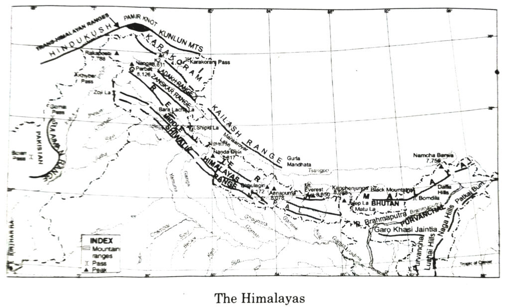
● The Himalayas—Three parallel ranges-the greater Himalayas, the lesser Himalayas and the Shiwaliks.
● Pamir Knot—The roof of the world.
● Glaciers of the Himalayas—Baltro and Siachen.
● K₂ Godwin Austin—The second highest peak of the world. (8611metres)
● Passes in Himalayas—Zoji la, Shipki la, Nathula, Bomdila.
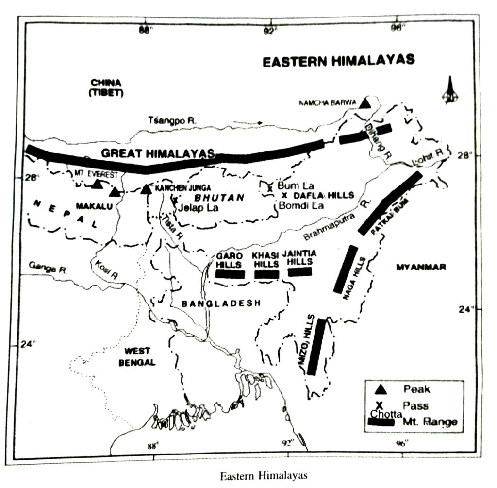
● Purvanchal—Patkoi, Naga, Lushai Hills.
● Sunderbans—Ganga Brahmaputra Delta.
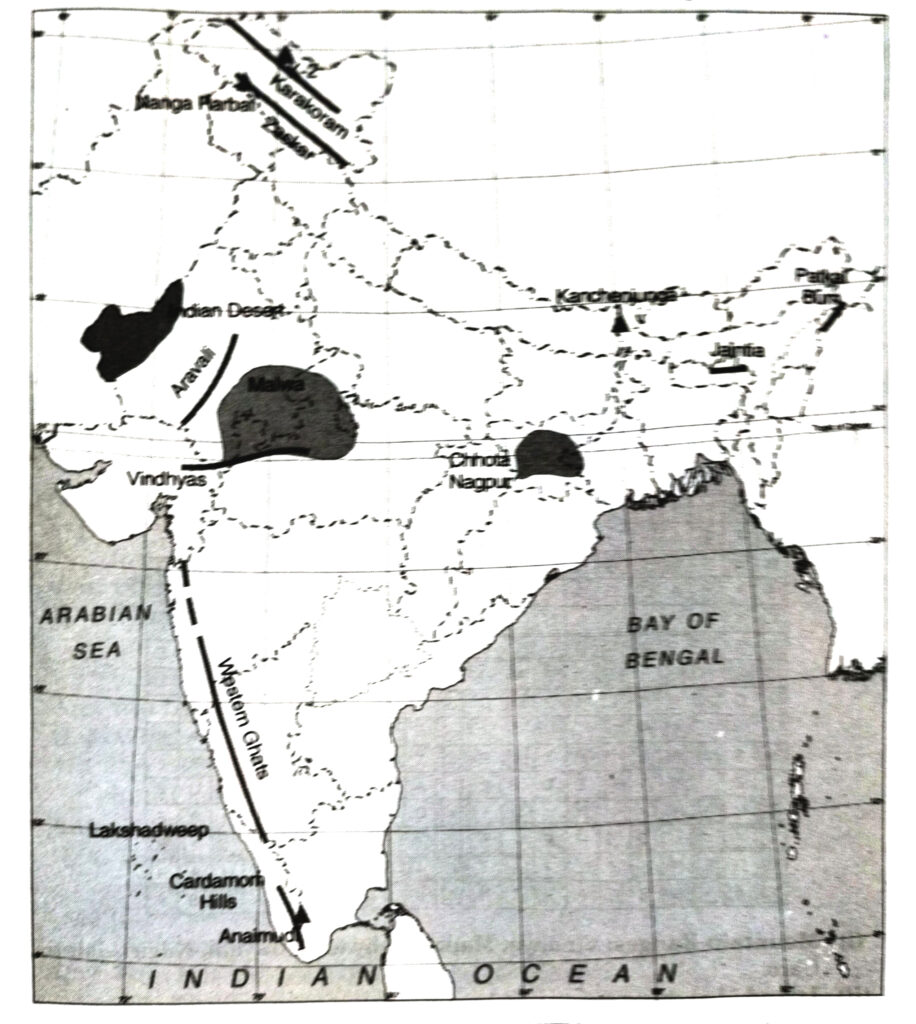
● Rift Valleys—Narmada and Tapti.
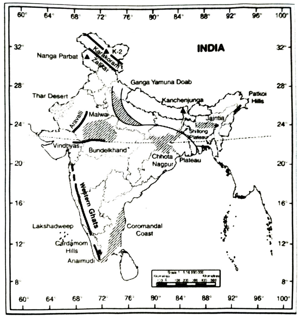
● Guru Shikhar—Highest peak in Aravallis (1722 metres).
● Central Highlands—Aravallis, Vindhyas and Satpuras.
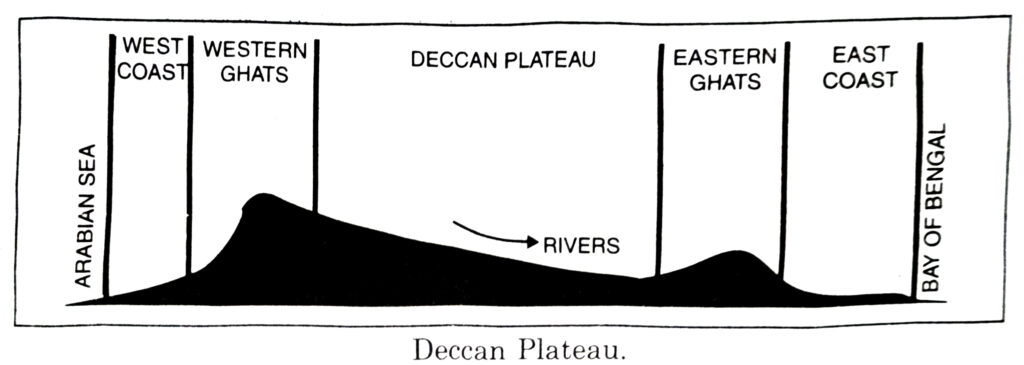
● Sahyadri—Western Ghats.
● Deccan Trap—N.W. plateau made up of lava.
● Passes in Western Ghats—Thal ghat, Bhor ghat, Pal ghat.
● Coastal Plain (West)— Konkan, Kanara, (Kannad), Malabar coast.
● Coastal Plain (East)—Coromandel, Utkal coast.
● Coral Islands—Lakshadweep islands.
● Lagoons (Lakes)—Chilka and Pulicat.
GEOGRAPHICAL TERMS
1. Terrain : Relief of the land.
2. Geological period : Period during the formation of earth.
3. Crust : The outermost part of the earth.
4. Folds : Due to compression, rocks form anticlines and synclines.
5. Faulting : Due to expansion, rocks move apart.
6. Gondwana land : A super continent which included Australia, Deccan plateau, Africa, South America.
7. Indo-Australian Plate : The tectonic plate between Indian ocean and Australia,
8. Tethys Sea : A narrow shallow depression which existed at the site of Himalayas.
9. Alluvial deposits : Deposits deposited by river.
10. Hamadri : The Great Himalayas.
11. Glacier : A river of moving ice.
12. Purvanchal : The eastern hills and mountains.
13. Khadar : The young deposits of river.
14. Bangar : The old deposits of river.
15. Thar : The great Indian desert of Rajasthan.
16. Barchans : Crescent shaped sand dunes.
17. Corals : Short lived polyps.
18. Lagoon : A shallow salty lake.
TEXTUAL QUESTIONS
Q. 1. Choose the right answer from the four alternatives given below :
(i) A landmass bounded by sea on three sides is referred to as :
(a) Coast
(b) Island
(c) Peninsula
(d) None of these
Ans.— (c) Peninsula.
(ii) Mountain ranges in the eastern part of India forming its boundary with Myanmar are collectively called :
(a) Himachal
(b) Uttarakhand
(c) Purvanchal
(d) None of these
Ans.— (c) Purvanchal.
(iii) The western coastal strip, south of Goa, is referred to as :
(a) Coromandel
(b) Konkan
(c) Kannad
(d) Northern circar
Ans.— (b) Konkan
(iv) The highest peak in the Eastern Ghats is :
(a) Anai Mudi
(b) Kanchenjunga
(c) Mahendragiri
(d) Khasi
Ans.— (c) Mahendragiri
Q. 2. Answer the following questions briefly.
(i) What is the Bhabar ?
Ans.— Bhabar is a long narrow plain along the foot hills. It is pebble studded zone (8-16 km wide).
Rivers are lost in this region.
(ii) Name the three major divisions of the Himalayas from north to south.
Ans.— The Himalayas have been uplifted by different mountain building movements. There are many parallel mountain ranges in the Himalayas. These ranges are separated from each other by longitudinal valleys called ‘Duns’. These ranges suggest different stages of folding. According to height, the different ranges are :
(a) The Great Himalayas or Inner Himalayas.
(b) The Lesser Himalayas or Middle Himalayas.
(c) The Shiwaliks or Outer Himalayas.
Karakoram ranges and Ladakh ranges are Trans-Himalayan ranges running parallel to one another. Zanskar ranges form the Great Himalayas. The lesser Himalayas in the form of Pir Panjal ranges and Dhauladhar ranges belong to middle Himalayas. The southernmost ranges of the Himalayas are known as the Shiwalik ranges.
(iii) Which plateau lies between the Aravali and the Vindhyan ranges ?
Ans.— Malwa Plateau.
(iv) Name the island group of India having coral origin.
Ans.— Lakshadweep.
Q. 3. Distinguish between
(i) Bhangar and Khadar
Ans.—
| Bhangar | Khadar |
| (a) It refers old alluvium or old soil. | (a) It refers to new alluvium or new soil. |
| (b) It contains coarse soil particles. | (b) It contains fine soil particles. |
| (c) A large part of the Northern plains are made up of this type of soil and hence, is very fertile. | (c) These are renewed every year and hence are very fertile and is ideal for intensive agriculture. |
| (d) It is dark in colour. | (d) It is light in colour. |
(ii) Western ghats and Eastern ghats.
Ans.—
| Western ghats | Eastern ghats |
| (a) The Western ghats form a continuous chain from Gulf of Khambat to Kanniyakumari. | (a) The Eastern ghats form a discontinuous chain of low hills from Odisha to Coromandel coast. |
| (b) These consist of Sahyadri, Nilgiris, Annamalai and Cardamom hills. | (b) The Eastern ghats are known by local names. |
| (c) The main passes in Western ghats are Thal ghat, Bhor ghat and Pal ghat. | (c) There are wide gaps in Eastern ghats, through which rivers flow. |
| (d) The average height is 900-1600 metres. The highest peak is Anaimudi (2,965 metres) in Kerala. | (d) The average height of Eastern ghats is 600 metres. The highest peak is Mahendragiri (1,501 metres). |
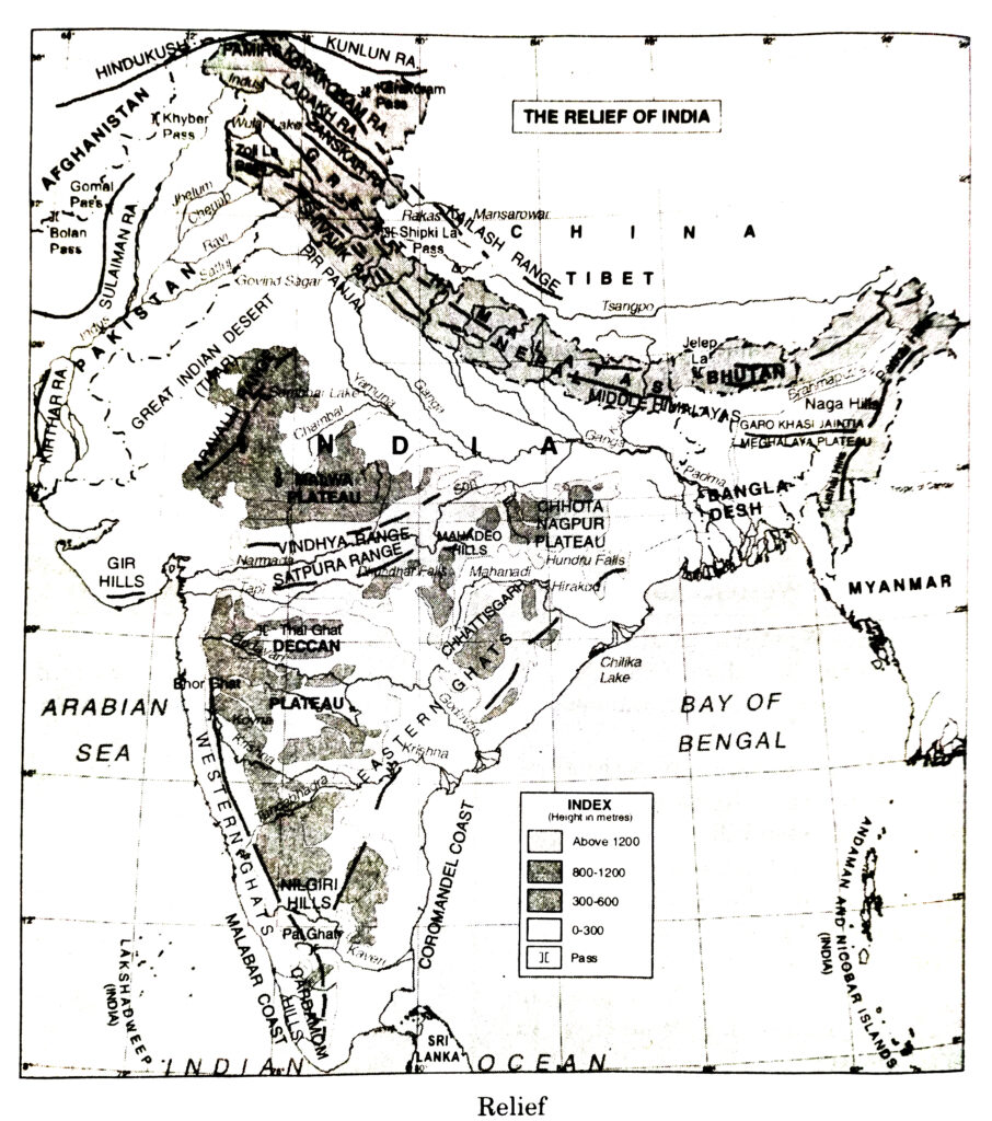
Q. 4. Which are the major physiographic divisions of India ? Contrast the relief of the Himalayan region with that of the Peninsular Plateau.
Ans.— India is a vast country where severe contrasts are found in relief. India is divided into 6 independent physiographic divisions :
(i) The Great Mountain Wall of the North; (ii) The Northern Plaina, (iii) The Great Peninsular Plateau; (iv) The Great Indian Desert; (o) The Coastal Reason, (vi) Islands.
Comparison of the geomorphological features of the Indian plateau with those of the Himalayas :
| Indian Plateau | The Himalayas |
| (a) The Indian plateau is an ancient crystalline tableland. | (a) The Himalayas are young new fold mountains. |
| (b) This plateau has been formed as a horst. | (b) These mountains have been formed due to folding by different earth movements. |
| (c) The plateau is old and well dissected. | (c) The relief features show young age of the Himalayas. |
| (d) Rift valleys are formed due to faulting. | (d) Parallel mountain ranges are formed in the Himalayan region. |
| (e) It is an old eroded crystal rock with the highest peak Anaimudi 2,695 mts. above sea level. | (e) These mountains are the loftiest mountain system of the world with the highest mountain peak Mt. Everest 8848 mts. above sea level. |
| (f) This plateau is triangular in shape. | (f) These mountains extend in an arc. |
| (g) Narrow deep river valleys are formed on the plateau. | (g) Deep gorges and U-shaped valleys are formed. |
| (h) This plateau has been lifted out of the sea in the pre-cambrian period (1600 million years ago). | (h) These have been formed out of Tethys sea in Mesozoic period (276 million years ago). |
Q. 5. Give an account of the Northern Plains of India.
Ans.— Northern Plains of India
The Great Plain extends in between the Himalayas and the Peninsular Plateau extending from Punjab Plains to Assam Valley. It is 2,400 km long and 240 to 320 km wide. Its average height is 150 metres. It covers an area of 7.5 lakh sq. km.
Division of Northern Plain
1. Bhabar and Terrai : It is a long, narrow zone along the foothills. It is a pebble studded zone. Swampy areas occur in Terai.
2. Punjab Plain : This plain has a slope in the South-West direction. It has been formed by the deposition of sediments by Ravi, Beas and Sutlej rivers. Chos (Seasonal streams) cause soil erosion in the foothills of Shiwaliks.
3. Ganga Plain : This plain has been formed by the deposition of sediments brought by the Ganga and its tributaries. It can be divided into three regionsupper Ganga plain, middle Ganga plain and the lower Ganga plain. It occupies an area of about 3.5 lakh sq. km. Sunderban Delta is formed in the lower Ganga plain. This fertile delta is the largest delta of the world.
4. Brahmaputra Plains : These plains are situated in the eastern part and are often known as Assam valley. The Brahmaputra river forms a large delta in Bangladesh. The river forms a narrow, deep gorge Dihang gorge’ which is 12,000 metres deep.
Q. 6. Write short notes on the following :
1. The Indian Desert
2. The Central Highlands
3. The Island Groups of India
Ans.— 1. The Indian Desert lies towards the western margin of the Aravallia. It is a sandy plain with the dunes. It has low rainfall of 150 mm. It has low vegetation cover and it has an arid climate.
2. The central highlands form the oldest structure of India. It is an ancient, stable, hard block formed by igneous and metamorphic rocks. It was a part of Gondwana land. The mountain ranges consist mostly of residual mountains. The plateaus consist of long narrow ridges which are storehouse of minerals.
3. There are about 550 islands in the Indian Ocean. Most of these islands are too small to be inhabited. These islands are found in the following groups.
(i) Andaman and Nicobar islands : These islands form two major groups in the Bay of Bengal. These are Andaman and Nicobar islands. These islands extend between 6° and 14° N latitudes for a distance of 500 kms and are 214 in number. The Nicobar group consists of 15 islands extending between 6°N to 10° N latitudes. Ten degree channel separates the Andaman group of islands from the Nicobar group. These islands form a Union Territory of India with Port Blair as its capital Indira Point in the Nicobar island in the southernmost point of the Indian Union. These islands form the summits of the submerged hills of the ocean floor. Barren islands and Narcondam islands, situated in north of Port Blair are volcanic islands. Barren island is the only active volcano in India which erupted on 10th April 1991.
(ii) Lakshadweep islands : These islands are situated in the Arabian Sea and lie 320 km off the coast of Kerala between 8° and 12° North latitudes. These are coral islands and some of these are ring shaped and called atolls. These are 27 in number and 17 of these are uninhabited. It is a U.T. with Kavarti as its capital. Pamban and Rameshwaram islands lie between India and Sri Lanka.
MAP SKILLS
Q. 1. On an outline map of India, show the following :
(i) Mountain and hill ranges: The Karakoram, the Zaskar, the Patkai Bum, the Jaintia, the Vindhya range, the Aravalli, and the Cardamom hills.
(ii) Peaks: K2, Kanchanjunga Nanga Parbat, Anai Mudi.
(iii) Plateaus : Chotanagpur, Malwa.
(iv) The Indian Desert, Western Ghats, Lakshadweep Islands.
PROJECT/ACTIVITY
Q. 1. Locate the peaks, passes, ranges, plateaus, hills and duns hidden in the puzzle. Try to find where these features are located. You may start your search horizontally, vertically or diagonally.
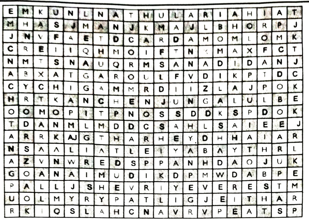
Ans.—
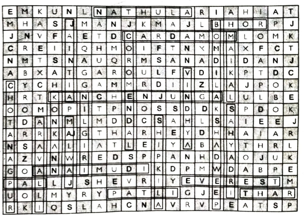
(i) Mountain Ranges : Vindhya, Maikal, Sahyadri, Aravalli, Nilgiri, Jaintia Garo.
(ii) Island : Lakshadweep.
(iii) Plateau : Chhotanagpur, Malwa.
(iv) Peaks : Kanchejunga, Everest, Animudi, Cardamom.
(v) Coast : Coromandal, Konkan,
(vi) Pass : Shipkila, Bomdi La, Nathu La,
(vii) Desert : Thar
(viii) Ghat : Bhor, Pal,
OTHER IMPORTANT QUESTIONS
Objective Type Questions
I. Multiple Choice Questions
SET-I
Choose the right answer from the four alternatives :
Q. 1. The highest peak of Himalayas in India is :
(i) Mt. Everest
(ii) Kanchenjunga
(iii) K-2
(iv) Dhaulgiri.
Ans.— (ii) Kanchenjunga.
Q. 2. The deposits of old alluvium are called :
(i) Khadar
(ii) Bangar
(iii) Bhabar
(iv) Terrai
Ans.— (ii) Bangar.
Q. 3. Which is the highest peak of southern India ?
(i) Doda Beta
(ii) Ansimudi
(iii) Mahendargiri
(iv) Kalsubai.
Ans.— (ii) Anaimudi.
Q. 4. Where is Pitli bird Sanctuary located ?
(i) Andaman islands
(ii) Nicobar islands
(iii) Lakshadweep
(iv) Maldives.
Ans.— (iii) Lakshadweep.
Q. 5. Which is a rift valley ?
(i) Ganga valley
(ii) Narmada valley
(iii) Chambal valley
(iv) Damodar valley.
Ans.— (ii) Narmada valley.
Q. 6. The Great Himalayas are also called :
(i) Siwalik
(ii) Himadri
(iii) Purvanchal
(iv) Himachal.
Ans.— (ii) Himadri.
Q. 7. Which is the longest range in Middle Himalayas ?
(i) Dhauladhar
(ii) Mahabharat
(iii) Pir Panjal
(iv) Karakoram.
Ans.— (iii) Pir Panjal.
Q. 8. The Himalayas between Sutlej and Kali Rivers is called :
(i) Panjab Himalayas
(ii) Kumaon Himalayas
(iii) Nepal Himalayas
(iv) Purvanchal.
Ans.— (ii) Kumaon Himalayas.
SET-II
Q. 1. The Himalayas have uplifted out of the :
(i) Tethys Sea
(ii) Arabian Sea
(iii) Red Sea
(iv) North
Ans.— (i) Tethys Sea.
Q. 2. The average height of Greater Himalayas is :
(i) 5,000 metres
(ii) 5.500 metres
(iii) 6,000 metres
(iv 6,500 metres
Ans.— (iii) 6,000 metres.
Q. 3. The length of Northern plain is :
(i) 2200 km
(ii) 2300 km
(iii) 2400 km
(iv) 2500 km.
Ans.— (iii) 2400 km.
Q. 4. All the streams from Himalayas disappear in :
(i) Bhabar region
(ii) Terai region
(iii) Khadar region
(iv) Bangar region.
Ans.— (i) Bhabar region.
Q. 5. Where is Dudhwa National Park located ?
(i) In Doab
(ii) In Terai
(iii) In Delta
(iv) In Bhabhar.
Ans.— (ii) In Terai.
Q. 6. Which river divides Peninsular India into two parts ?
(i) Narmada
(ii) Tapti
(iii) Mahanadi
(iv) Godavari.
Ans.— (i) Narmada.
Q. 7. Ravines or bad lands are found in :
(i) Chambal valley
(ii) Sone valley
(iii) Damodar valley
(iv) Betwa valley.
Ans.— (i) Chambal valley.
Q. 8. Where is Karbi-Anglong plateau located ?
(i) in Assam
(ii) in Meghalaya
(iii) in Mizoram
(iv) in Arunachal Pradesh.
Ans.— (ii) in Meghalaya.
Q. 9. Barchans are found in area of :
(i) Jodhpur
(ii) Jaipur
(iii) Jaisalmer
(iv) Ganganagar.
Ans.— (iii) Jaisalmer.
Q. 10. The largest salt water lake in India is :
(i) Sambhar
(ii) Chilka
(iii) Vembnad
(iv) Kolleru.
Ans.— (ii) Chilka.
II. Fill in the Blanks
1. ……… is the highest peak in the world.
2. ……… is called the roof of the world.
3. Areas of older alluvium are called …………. .
4. …………. island group of India is having coral islands.
5. ……….. valley is a rift valley.
6. ………. the lake deposits found in kashmir valley.
7. ………. are circular or …………… shaped coral reefs.
8. A delta resembles the Greek letter ……….. .
9. Land between two rivers is called
10. ………. is a bird Sanctuary located in Lakshadweep.
Ans.— 1. Mt. Everest, 2. Pamir knot, 3. Bhanger, 4. Lakshadweep, 5. Karewas, 6. Narmada, 7. Atolls, Horse-shoe, 8. Delta, 9. Doab, 10. Pitli.
III. True/False
1. Cardamom hills are located in Kerala.
2. Sunderban is the world’s smallest and slowest growing delta.
3. Peninsular India is the ancient landmass in India.
4. Himadri are the great Himalayas.
5. Anai Mudi is the highest peak in the peninsular India.
Ans.— 1. √, 2. x, 3. √, 4. √, 5. √.
Very Short Answer Type Questions
THE HIMALAYAN MOUNTAINS
Q. 1. What name was given to a super continent in ancient period ?
Ans.— Gondwana land (The oldest landmass).
Q. 2. Which is the ancient (oldest) landmass in India ?
Ans.— Peninsular India.
Q. 3. Name the sea which existed in place of the Himalayas.
Ans.— Tethys.
Q. 4. Name the lake deposits found in Kashmir valley.
Ans.— Karewas.
Q. 5. Where is K₂ peak located ?
Ans.— It is located in Karakoram mountains.
Q. 6. Name three mountain ranges beyond Himalayas.
Ans.— Karakoram, Ladakh, Kailash.
Q. 7. What is the height of the highest peak in Himalayas ?
Ans.— Mt. Everest (8848 metres).
Q. 8. What is the height of the highest peak of Himalayas located in India ?
Ans.— Kanchenjunga (8598 metres).
Q. 9. Name three Trans-Himalayan rivers.
Ans.— Indus, Sutlej, Brahmaputra.
Q. 10. Name two hill stations of Pir Panjal ranges.
Ans.— Gulmarg and Pahalgam.
NORTHERN PLAINS
Q. 1. What is a Doab ?
Ans.— Land between two rivers.
Q. 2. What name is given to joint stream of Ganga and Brahmaputra in Bangladesh ?
Ans.— Meghna.
Q. 3. Divide the western coastal plain into three sections.
Ans.— Malabar coast, Kannad coast and Konkan coast.
Q. 4. Which is the world’s largest and fastest growing delta ?
Ans.— Sunderban (Ganges delta).
Q. 5. Into which four parts the northern plain is divided ?
Ans.— Bhabar, Terai, Bhangar, Khadar.
PENINSULAR INDIA
Q. 1. Name the two broad dimensions of Peninsular plateau.
Ans.— (i) Central Highlands, (ii) Deccan Plateaus.
Q. 2. Which National park is there in Terai region ?
Ans.— Dudhwa.
Q. 3. Name three plateaus of Central Highlands.
Ans.— Malwa, Bundel Khand and Baghel Khand.
Q. 4. Name three prominent hills of N.E. hilly region.
Ans.— Garo, Khasi, Jaintia.
Q. 5. Name three passes in Western Ghats.
Ans.— Thal Ghat, Bhor Ghat, Pal Ghat.
Q. 6. Name the largest salt water lake in India.
Ans.— Chilka (Orissa).
Q. 7. Name a bird Sanctuary located in Lakshadweep, cleoul mokeoll
Ans.— Pitli.
Q. 8. Where are Cardamom Hills located ?
Ans.— In Kerala.
Q. 9. What are distributaries ?
Ans.— The deposition of silt splits the river into channels in lower course and are called distributaries.
Q. 10. What are atolls ?
Ans.— Atolls are circular or horse-shoe shaped coral reefs.
Q. 11. Define Rift Valley ?
Ans.— A rift valley is a linear shaped lowland between many highlands or mountain ranges created by the action of a geologic rift or fault.
Short Answer Type Questions
Q. 1. ‘Great Himalayas are the loftiest range in the world.’ Justify the statement giving examples of some high peaks.
Ans.— (i) Great Himalayas are the loftiest range because (i) these contain most of the eight thousander peaks’ of the world. (ii) The Mount Everest or Sagarmatha (in Nepal), the highest peak of the world is 8848 metres above sea level. (iii) Kanchenjunga (8598 metres) lies in Sikkim and is the highest peak of the Himalayas in India. (iv) Makalu (8481) in Nepal, Dhaulgiri (8172 metres) in Nepal, Naga Parbat (8126 metres) in Kashmir, Nanda Devi (7816 metres) in Uttarakhand, Namcha Barwa (7756 metres) in Arunachal Pradesh are some other important peaks of the Himalayas.
Q. 2. Name the important passes in the Himalayas. Explain their importance.
Ans.— A pass is a gap in a mountain range and provides a natural route. The Himalayas act as a physical barrier in the north, but there are some passes to cross these lofty mountains. (i) Karakoram pass lies on the Karakoram mountains and connects Kashmir. (ii) Shipki la pass lies in Himachal Pradesh and connects Tibet Himalayan road. (iii) Zoji la pass connects Srinagar and Leh (Ladakh). (iv) Nathu la pass in Sikkim connects Sikkim with Lhasa, capital of Tibet. (v) Bomdi la pass in Arunachal Pradesh serves as trade route through Chumbi Valley in Bhutan.
Q. 3. Which mountain ranges constitute the Purvanchal ?
Ans.— The Brahmaputra marks the easternmost geographical limit of the Himalayas.
The Himalayas, making a hairpin bend, extend southward. The mountains situated along the eastern boundary of India are called Purvanchal. These mountains are of medium height. These include Patkoi and Naga Hills in the north, Lushai hills in south, Mizo hills in Mizoram. These also include Garo, Khasi, Jaintia hills in Meghalaya. These mountains are less spectacular than Western Himalayas.
Q. 4. “Physiographic divisions of India are complementary to each other,” Discuss.
Ans.— India is divided into three major physiographic divisions i.e. the Himalayas, the Northern plains and the Peninsular plateau. (i) The peninsula is the core of the geology of India. It is a stable block of hard rocks around which other physiographic divisions have been formed. (ii) The plateau is a storehouse of minerals which are the base of industrialisation of India. The northward drifting of peninsular plateau led to the formation of Himalayas. (iii) The Himalayas adorn like a crown. These are the source of forest and water wealth. These enclose the Indian sub-continent, (iv) Sediments brought down from the Himalayas have been deposited to form the northern plains. (v) The Gangetic plain is the cradle of Indian civilisation. These are the Granaries of the country. (vi) The coastal regions provide sites for fishing and ports. Thus three physiographic divisions help to strengthen the forces of unity of our people.
Q. 5. What are Shiwaliks ? Write two characteristics of it.
Ans.— The southernmost ranges of the Himalayas are called Shiwaliks. These are the foothills of the Himalayas and are called outer Himalayas. These represent the latest phase of folding, (i) These are made of loose, unconsolidated river deposits. (ii) These are prone to earthquakes and landslides. (iii) Soil erosion is at its worst due to deforestation. (iv) Their average height is less than 1000 metres.
Q. 6. What is a Dun ? Give examples from the Himalayan region.
Ans.— A Dun is a narrow longitudinal valley lying in between the Shiwaliks and the lesser Himalayas. These are formed by deposition of sediments. The Dune in the Kumaon Himalayas such as Dehradun, Kothridun, Patli and Kulu and Kangro in Himachal Pradesh are well known. The Kashmir valley is a classical example of Dun valley. Kathmandu valley in Nepal is another example. These beautiful valleys are star attractions for the tourists from all over the world. The Kashmir valley is known as ‘Paradise on the earth’.
Q. 7. What are the great Himalayas ? Write main characteristics of the great Himalayas.
Ans.— The northernmost ranges of Himalayas are called great Himalayas because these have some of the highest peaks of the world. These are also called Himadri because these peaks are always covered with snow. These young fold mountains are shaped and are compared to a sword or a bow. Youthful rivers form narrow deep valleys and gorges across these ranges. These ranges show evidence of glaciation such as Karewas in Kashmir.
Q. 8. Write any four main features of the Ganga Basin.
Ans.— Ganga basin, a part of northern plains, lies at the foot of the Himalayas. It is an alluvium plain formed by the deposition of sediments brought from the Himalayas by rivers. It is a dead flat lowland. It has a gentle gradient (1/4 metres per km). It has fertile alluvial soils namely Khadar and Bangar which have led to the development of Agriculture. The Basin has been divided into many Doabs.
Q. 9. Write any four characteristics of Ganga-Brahmaputra Delta.
Ans.— A delta is a triangular piece of land formed by the deposition of sediments at the mouth of a river. (i) The Ganga-Brahmaputra Delta is the largest delta in the world. (ii) The Brahmaputra after joining the Ganga is divided into several distributaries. Due to gentle slope, the river deposits the sediments. It is the most fertile delta because it is well watered. (iii) With the development of several channels, it has developed as a classical delta. (iv) The lower part of Delta is marshy due to tides and is known as ‘Sunderbans’. (v) It is one of the fastest growing deltas as the land is advancing towards the sea because the deposition is still going on.
Q. 10. Describe the Regional division of Himalayas on the basis of boundaries of river valleys.
Ans.— Regional Division. Between the two hairpin bends, from Kashmir to Assam. The Himalayas between Indus and Brahmaputra have been divided into four parts.
(i) Assam Himalayas. Between Tista-Brahmaputra (720 km)
(ii) Nepal Himalayas. Between Kali-Tista (800 km)
(iii) Kumaon Himalayas. Between Sutlej-Kali (320 km)
(iv) Panjab Himalayas. Between Indus-Sutlej (560 km)
Q. 11. Divide Himalayas into different parts on the basis of height.
Ans.— According to height, four parallel ranges are found in the Himalayas.
(i) Trans Himalayas
(ii) Great Himalayas or Inner Himalayas
(iii) Lesser Himalayas or Middle Himalayas
(iv) Sub Himalayas or Shivaliks.
Q. 12. What do you understand by the term “Doab” ? Give five examples from the Indian sub-continent.
Ans.— Doab is a flood-plain formed in between two rivers. Doabs separate two rivers but maintain a uniform character over the whole areas. Five Doabs in Punjab maintain a physical unity of the Punjab plains. Doab is made up of two words: ‘do’ means two and ‘ab’ means water.
(i) Bist Jalandhar Doab. Between the Sutlej and the Beas.
(ii) Bari Doab. Between the Beas and the Ravi.
(iii) Rachna Doab. Between the Ravi and the Chenab.
(iv) Chaj Doab. Between the Chenab and the Jhelum.
(v) Sind Sagar Doab. Between Jhelum-Chenab and the Indus Rivers.
Q. 13. Divide Northern plains into four regions based on variations in relief.
Ans.— On the basis of relief, the Northern plain is divided into four sections :
(i) Bhabar plain. It is located in the foothills of mountains. Rivers are lost in this section.
(ii) Terai plain. South of Bhabar lies the Terai belt. The rivers reappear in this swampy and marshy region.
(iii) Bhangar plain. The flood plain formed by old alluvium is called Bhangar plain.
(iv) Khadar plain. The new young deposits of flood plain is called Khadar.
Q. 14. Divide the Eastern Coastal plain and the Western Coastal plain into different sections.
Ans.—Western Coastal Plain
(i) Konkan Coast. Mumbai to Goa.
(ii) Kannad Coast. Goa to Cochi.
(iii) Malabar Coast. Cochi to Kanyakumari.
Eastern Coastal Plain
(i) Northern Circar Coast. From West Bengal to Andhra Pradesh.
(ii) Coromandel Coast. From Andhra Pradesh to Kanyakumari.
Q. 15. Why are the Himalayas called the young fold mountains ?
Ans.— The Himalayas are called young fold mountains because they have been formed in the very recent geological period, i.e., tertiary period (About 70 million years ago). (i) These are not very old mountains. (ii) The glacial deposits (Karewas in Kashmir) and deposits of Shiwalik ranges suggest the young age of the Himalayas. (iii) The Himalayan folds have been formed during different mountain building periods. (v) It has been observed that Himalayas are still rising.
Q. 16. “All the major physical features are found in India” Do you agree ? Explain.
Ans.— Yes, we are agree with this statement due to the following reasons:
(i) India’s relief has many contrasts. The relief features in hilly areas and plains are quite different.
(ii) In hilly regions, there is rugged terrain of mountains.
(iii) In plains there are vast stretches of plains or lowland.
(iv) The desert region is covered with sand in the Western Rajasthan.
(v) Plateaus are in southern region of India while two island groups are in Bay of Bengal and Arabian Sea respectively.
In fact, India has all major physical features of the earth.
COMPARISON TYPE QUESTIONS
Q. 1. Distinguish between a Delta and an Estuary.
Ans.—
| Estuary | Delta |
| 1. An estuary is a funnel shaped channel at the mouth of a river. | 1. A delta in a triangular shaped land formed at the mouth of a river. |
| 2. An estuary is a long narrow channel. | 2. A delta resembles the Greek letter delta (D) |
| 3. Due to swift current and steep slope, deposition of sediments takes place. | 3. Due to slow speed, and gentle slope, deposition of sediments does not take place. |
| 4. Estuaries are formed where tides and currents of a delta melt. | 4. Absence of tides and currents favour the formation are strong |
| 5. Narmada and Tapti rivers make estuaries on the West coast. | 5. Ganges-Brahmaputra Delta is the biggest delta in the world. |
Q. 2. Distinguish between Western Himalayas and Eastern Himalayas.
Ans.—
| Western Himalayas | Eastern Himalayas |
| 1. The Western Himalayas extend in the states of Jammu and Kashmir and Himachal Pradesh. | 1. The Eastern Himalayas extend in the states of West Bengal, Sikkim and Arunachal Pradesh. |
| 2. These are called Kashmir Himalayas and Kumaon Hills. | 2. These are called Purvanchal and Assam Himalayas. |
| 3. These include Zaskar ranges, Karakoram mountains, Pir Panjal and Dhauladhar Hills. | 3. These include Patkoi, Naga, Lushai hills and extend upto Garo-Jaintia-Mizo hills. |
| 4. The Western Himalayas have a high altitude where K₂ (8611 metres) is the highest peak. | 4. The Eastern Himalayas have a medium altitude where Namcha Barwa (7756 metres) is the highest peak. |
| 5. These ranges have the passes of Karakoram, Shipki la, Zoji la. | 5. These ranges have the passes of Nathu la, Bomdi la. |
| 6. These ranges enclose beautiful valley of Kashmir. | 6. These ranges enclose the Brahmaputra valley. |
Q. 3. Give three points of difference between the Western coastal plain and Eastern coastal plain.
Ans.—
| Western Coastal Plain | Eastern Coastal Plain |
| 1. West Coast is a narrow alluvial plain with a width of 50-80 kms. It is uneven and wet. | 1. The Eastern Coast has a wide plain with well developed delta 80 to 120 km wide. It is level and dry. |
| 2. Beautiful lagoons are found on the Malabar Coast. | 2. The Eastern Coast has only two or three lagoons. |
| 3. The short swift rivers do not make any deltas on the Western Coast. The Tapti and Narmada make estuaries. | 3. The large rivers make wide deltas on the Eastern Coast. Mahanadi, Godavari, Krishna, Cauvery make well-developed deltas. |
| 4. Kandla, Mumbai, Marmagao, Mangalore and Cochin are major ports on West coast. | Tuticorin, Chennai, Vishakhapatnam, Paradeep and Kolkata are major ports on the East coast. |
Q. 4. Distinguish between Terai and Bhabar regions.
Ans.—
| Terai | Bhabar |
| 1. Terai is a broad long zone south of Bhabar plain. | 1. Bhabar is a long narrow plain along the foothills. |
| 2. It is a marshy damp area covered with thick forests. | 2. It is a pebble studded zone of porous beds. |
| 3. It is 20-30 km wide. | 3. It is 8-16 km wide. |
| 4. Many streams re-emerge here from the Bhabar area. | 4. Streams are lost in the region due to porous rocks. |
| 5. It is suitable for agriculture. | 5. It is unsuitable for agriculture. |
Long Answer Type Questions
Q. 1. Compare the Indo-Gangetic plain with the Deccan plateau.
Ans.—
| Deccan Plateau | Indo-Gangetic Plain |
| 1. Location. It is a triangular plateau bounded by Vindhyas, Western ghats and Eastern ghats. | 1. It is an alluvial plain stretching from Punjab to Assam valley. |
| 2. Relief. The relief of this plateau is uneven. Its average height above sea level is more than 600 metres. | 2. This is a level plain about 200 metres high above sea level. |
| 3. Climate. The climate here is hot and humid. | 3. Here the summers are hot and winters are cold. |
| 4. Crops. Jowar, Bajra, Spices and Groundnut are grown here. | 4. Rice, Wheat, Cotton and Sugarcane are mostly grown here. |
| 5. Rivers. Cauvery, Mahanadi, Godavari, Narmada and Tapti are main seasonal rivers here. | 5. Ganga, Yamuna and Brahmaputra are the main perennial rivers. |
| 6. Irrigation. Irrigation here is mainly done by Tanks. | 6. Wells, Tubewells and Canals are the main sources of irrigation here. |
| 7. Transport. Means of transport ed are rare here. | 7. A network of Railways and roads is laid here. |
| 8. Minerals. Gold and Manganese are the main minerals of this plateau. | 8. Iron, Coal and Mica are the important minerals of these plains. |
| 9. Population. The population is very thin. | 9. The population is very dense. |
| 10. Soils. Soils are made up of lava especially black soil. | 10. Alluvial soils are found. |
Q. 2. Give a brief description of the Great Peninsular Plateau.
Ans.— THE PENINSULAR PLATEAU
The Deccan Plateau is the oldest structure of India. It is the core of the geology of India. The average altitude of the plateau varies from 600 to 900 metres. Its limits are formed by the Aravallis in the North, Rajmahal Hills and Shillong plateau in the East. It was part of Gondwana land.
Division of Peninsular Plateau. A series of low hills, known as Satpura ranges between 21° N to 24° N latitudes divided the Peninsular plateau into two parts. (a) Malwa Plateau (b) Deccan Plateau.
(a) Malwa Plateau. The Malwa plateau covers a large part of central highlands. It extends from Aravallis in the West, Ganges valley in the North and East, and Vindhyas in the South. The Aravallis are residual mountains or Relict Mountains. Its highest peaks are Mt. Abu (1158 metres) and Guru Shikhar (1722 metres). This plateau includes Bundelkhand, Baghel Khand and Chambal valley.
(b) Deccan Plateau. This plateau lies South of Narmada river. It is surrounded by mountain ranges on three sides-Western Ghats, Eastern Ghats and Satpuras. Narmada and Tapti valleys are rift valleys between Satpuras and Vindhyas.
(i) Western Ghats. Western Ghats extend from Tapti valley up to Kanya Kumari for about 1500 km. It has three passes-Thal ghat, Bhor ghat and Pal ghat.
(ii) Eastern Ghats. Eastern Ghats extend for about 800 km from Mahanadi valleys upto Nilgiris. These are not continuous ranges. Rivers form wide gaps. Javadí, Shevroy and Nallamalai hills are found in the Southern part.
(iii) Nilgiris. Western ghats and Eastern ghats join together to form a knot known as Nilgiris. Anai Mudi (2698 metres) is the highest peak. Anaimalai, Palni, and Cardamom Hills are found in the southern part.
Q. 3. Name the major peaks of Himalayas (with a height of more than 8000 metres) and name the states in which these are situated.
Ans.—
| Peak | Height | Country |
| 1. Mt. Everest | 8848 metres | Tibet-Nepal border |
| 2. K₂-Godwin Austin | 8611 metres | Jammu and Kashmir |
| 3. Kanchenjunga | 8598 metres | Sikkim |
| 4. Makalu | 8481 metres | Nepal |
| 5. Dhaulagiri | 8172 metres | Nepal |
| 6. Nanga Parbat | 8126 metres | Jammu and Kashmir |
| 7. Annapurna | 8078 metres | Nepal |
Q. 4. Describe the Major Physiographic divisions of J&K state.
Ans.— The main physical divisions of our state of Jammu and Kashmir are :
Jammu (Sub-Himalayan)
(a) The outer plains
(b) The Shiwaliks
(c) The middle Himalayas
Kashmir (Sub-Himalayan)
(a) The valley
(b) The Karewas
(c) The side Valley
Kashmir (Sub-Himalayan)
(a) Karakoram Range
(b) The Ladakh Range
(c) The Zanskar Range
Jammu (Sub-Himalayan)
Ladakh (Trans-Himalayan)
1. Karakoram Range
2. The Ladakh Range
3. The Zanskar Range
(a) Outer Plains. The outer plains is an extension of Great Indian Plain and is alluvial in nature. It stretches from river Ravi to river Chenab Akhnoor, Ranbir Singh Pora, Samba and kathua are the main areas of outer pains. It is locally known as Anderwah and Bajwat. Besides, the Ravi & Chenab, the outer plains are drained by Ujh: Basantar, Tawi and Manawar Tawi rivers.
(b) The Shivaliks. The Shivaliks are commonly known as Himalayan foot hills. The Shivaliks lie to the north of Jammu between Ravi & Jhelum rivers.
(c) The Middle Himalayas. This region sprawls between river ravi in the east and Poonch in the west and continues towards Muzzafarabad in Pakistan controlled Kashmir. The middle Himalayas are dotted by small valleys. Trikuta mountains with the famous cave of Vaishno Devi is located in middle Himalayas. This area is very rich in forest resources.
The Jammu-Srinagar National Highway (293 km) has been carved out through the mid-Himalayas. IRCON has started to lay a railway tract from Udhampur to Qazigund through these mountains.
Bhaderwah and Kishtwar are the famous valleys of this region. The Pir Panjal mountains is a part of middle Himalayas. Kashmir (Sub-Himalayan) :
(a) The Valley. The Valley is girdled by mountains from all the sides. The famous mountains are Pir Panjal, Nanga Parbat, Tosh Maidan, Mahadev, Gwasbrari, Amarnath, Kazinag and Harmukh etc.
The Kashmir valley is a real paradise on earth having salubrious climate, scenic beauty, winding streams and lush green forests.
(b) The Karewas. The Karewas are lacustrine deposists and are the unique features of Kashmir Valley. Karewas are flat topped features ideal for saffron and fruit cultivation. The Karewas occupy about 50% of the total valley floor. The Karewas are flanked on one side by mountains while on the other, their gentle slopes touch the ground level or the valley floor.
(c) The side Valley. The famous side valleys of the Himalayan Kashmir are :
1. Lider valley
2. Sindh valley and
3. Lolab velley
4. Kishanganga valley.
Ladakh (Trans-Himalayan)
(a) Karakoram Range. They are black mountains with total length of 400 km. The World’s 2nd highest peak, K2 or Godwin Austin is located in this range. There are famous glaciers like Siachin, Biafo, Hirpar and Baltoro.
(b) The Ladakh Range. It lies to the south of Karakoram range between the river Indus and its famous tributary i.e. Shyok.
(c) The Zanskar Range. This range is famous for its two river valleys i.e. the Zanskar valley and Sooru valley. The area is very cold.
MAP SKILLS
TEXTUAL QUESTIONS
Q. On the outline map of India, show the following :
(i) Mountain and hill ranges : The Karakoram, the Zaskar, the Patkai Bum, the Jaintia, the Vindhya range, the Aravalli, and the Cardamom hills.
(ii) Peaks : K₂, Nanga Parbat, Anai Mudi.
(iii) Plateaus: Chhotanagpur, Malwa.
(iv) The Indian Desert, Western Ghats, Lakshadweep Islands.
PROJECT /ACTIVITY
Q. Locate the peaks, passes, ranges, plateaus hills, and details hidden in the Puzzle. Try to find where these features are located. You may start your search horizontally, vertically or diagonally.

Ans.— (i) Passes. Nathula, Bomdila, Shipkila.
(ii) Ghats. Bhor, Pal.
(iii) Hills. Garo, Khasi, Cardamom, Jaintia, Nilgiri.
(iv) Mountain Ranges. Vindhya, Maikal, Sahyadri , Aravalli.
(v) Island. Lakshadweep.
(vi) Plateau. Chhota Nagpur, Malwa.
(vii) Peaks. Kanchenjunga, Everest, Anaimudi.
(viii) Coast. Coromandal, Konkan.
Follow on Facebook page – Click Here
Google News join in – Click Here
Read More Asia News – Click Here
Read More Sports News – Click Here
Read More Crypto News – Click Here