JKBOSE 9th Class Social Science Solutions Chapter 3 Drainage
JKBOSE 9th Class Social Science Solutions Chapter 3 Drainage
JKBOSE 9th Class Social Science Solutions Chapter 3 Drainage
Jammu & Kashmir State Board JKBOSE 9th Class Social Science Solutions
J&K class 9th Social Science Drainage Textbook Questions and Answers
MAIN POINTS
● Two Drainage Systems—Rivers of Northern India.— Rivers of Peninsular India.
● Rivers Drain into two seas— (i) Bay of Bengal.—(ii) Arabian Sea.
● Rivers-a multiple resource—Basis of irrigation, water power generation, inland water transport, domestic and industrial water supply.
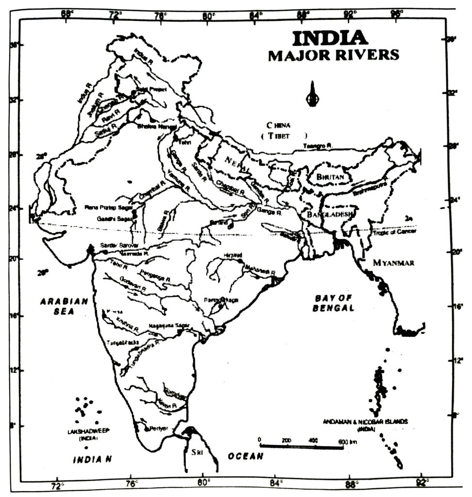
● Main Rivers of Northern India—Indus, Ganges and Brahmaputra (Perennial).
● Main Rivers of Southern India—Mahanadi, Godavari, Krishna and Cauvery (Seasonal).
● Trans-Himalayan—Indus, Sutlej, Brahmaputra Rivers
● Vindhyan Ranges— Water divide between rivers of Northern plains and Peninsular India.
● The largest delta—Sunderbans (Ganga-Brahmaputra).
● Lagoons—Pulicat and Chilka lakes.
● ‘Sorrow of Bengal’—Damodar river.
● ‘Sorrow of Bihar’—Kosi river.
● Famous waterfall—Jog Falls (271 metres).
GEOGRAPHICAL TERMS
1. Drainage : Drainage describes the river system of an area.
2. Water divide : An upland area separating two drainage basins.
3. Drainage Basin : The area drained by a single river system.
4. Perennial rivers : Rivers which have water throughout the year.
5. River system : A river alongwith the tributaries may be called a river system.
6. Lagoon : A part of sea cut off from sea sand bars to form a lake.
7. Gorge : A narrow deep opening formed by a river in its upper course,
8. Inland drainage : A drainage system in which rivers do not reach the ocean.
9. Braided river : In its lower course, when river is divided into many channels.
10. Oxbow lake : In a flood plain, a part of river is cut off to form an ox bow lain, a part of rive lake.
TEXTUAL QUESTIONS
Q. 1. Choose the right answer from the four alternatives given below :
(i) In which of the following states/union territories is the Wular lake located ?
(a) Rajasthan
(b) Uttar Pradesh
(c) Punjab
(d) Jammu and Kashmir.
Ans.— (d) Jammu and Kashmir.
(ii) The river Narmada has its source at :
(a) Satpura
(b) Brahmagiri
(c) Amarkantak
(d) Slopes of the Western Ghats.
Ans.— (c) Amarkantak.
(iii) Which one of the following lakes is a salt water lake ?
(a) Sambhar
(b) Dal
(c) Wular
(d) Gobind Sagar.
Ans.— (a) Sambhar.
(iv) Which one of the following is the longest river of the Peninsular India ?
(a) Narmada
(b) Krishna
(c) Godavari
(d) Mahanadi.
Ans.— (c) Godavari.
(v) Which one amongst the following rivers flows through a rift valley ?
(a) Mahanadi
(b) Tungabhadra
(c) Krishna
(d) Tapi.
Ans.— (d) Tapi.
Q. 2. Answer the following questions briefly
(i) What is meant by a water-divide ? Give an example.
Ans.— A raised area separating the head streams of two different river systems is called a water-shed or water-divide. In India, the Ganga river system flows eastward and drains into the Bay of Bengal, while the Indus river system flows westward and drains into the Arabian Sea. The area near Ambala with a height of 283 metres is the water divide between the Ganga and the Indus. It separates two drainage basins.
(ii) Which is the largest river basin in India ?
Ans.— The Ganga-Brahmaputra river basin is the largest in India. The Ganga river is 2,525 km. long and the Brahmaputra river is 2,900 km. long. The two rivers join together to form the largest delta of the world.
(iii) Where do the river Indus and Ganga have their origin ?
Ans.— River Indus and Ganga are Himalayan rivers.
(a) River Indus rises in Tibet near Lake Mansarovar.
(b) River Ganga rises from the Gangotari Glacier.
(iv) Name the two headstreams of the Ganga. Where do they meet to form the Ganga ?
Ans.— The head waters of the Ganga called the Bhagirathi is fed by the Gangotari Glacier and is joined by the Alaknanda at Devaprayag in Uttarakhand. The two join to form the Ganga river.
(v) Why does the Brahmaputra in its Tibetan part have less silt, despite a longer course ?
Ans.— Most of the course of the Brahmaputra lies in Tibet. It enters India in Arunachal Pradesh. The river is called Tsangpo in Tibet. Here, the volume of water of the river is less and has less silt. But in India, the river has large volume of water and more silt. The river has a braided channel in Assam.
(vi) Which two Peninsular rivers flow through a trough ?
Ans.— Narmada and Tapi.
(vii) State some economic benefits of rivers and lakes.
Ans.— Economically, rivers are very beneficial for a nation’s economy. Rivers provide us valuable resources such as alluvial soils, water for irrigation facilities, water transports in coastal regions, etc. Recreation, tourist promotion and fishing are also being developed along water fronts to gain economic benefits.
Q. 3. Below are given names of a few lakes of India. Group them under two categories natural and created by human beings.
(a) Wular
(b) Dal
(c) Nainital
(d) Bhimtal
(e) Gobind Sagar
(f) Loktak
(g) Barapani
(h) Chilika
(i) Sambhar
(j) Rana Pratap Sagar
(k) Nizam Sagar
(l) Pulicat
(m) Nagarjuna Sagar
(n) Hirakud.
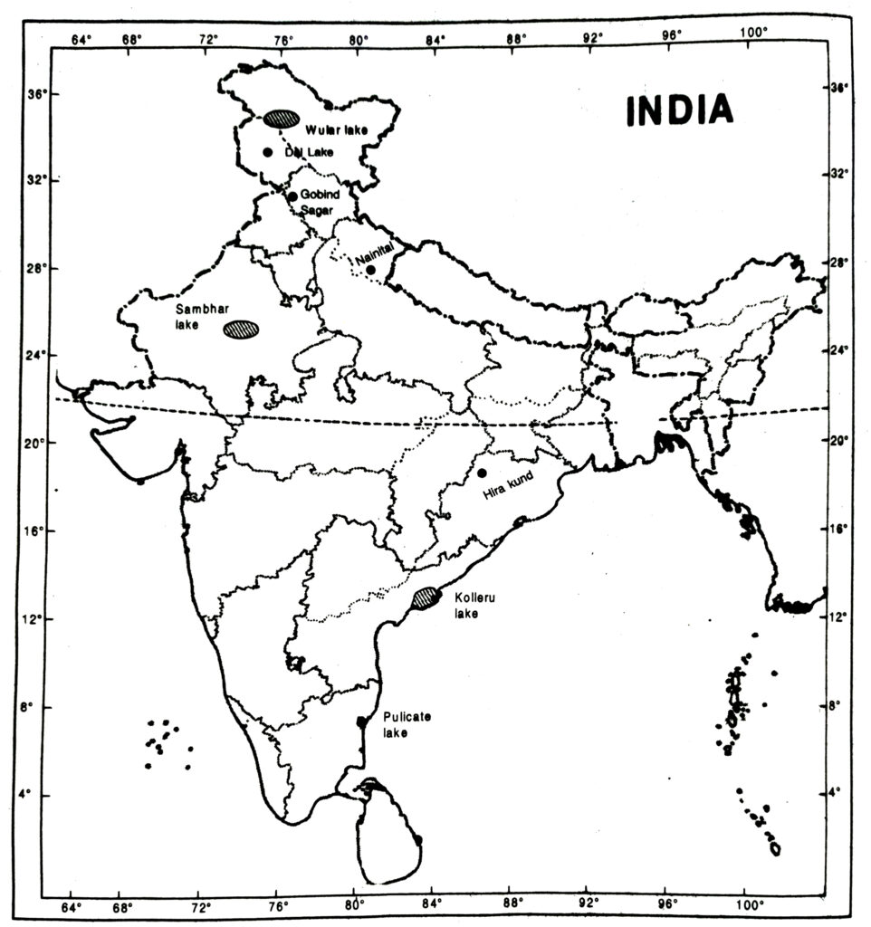
Ans.— Natural lakes : (a) Wular, (b) Dal, (c) Nainital, (d) Bhimtal, (f) Loktak, (g) Barapani, (h) Chilika, (i) Sambhar, (j) Pulicat.
Man-made lakes : (e) Gobind Sagar, (j) Rana Partap Sagar, (k) Nizam Sagar, (m) Nagarjuna Sagar,
(n) Hirakud.
Q. 4. Discuss the significant difference between the Himalayan and the Peninsular rivers.
Or
How are Peninsular rivers different from Himalayan rivers ? Give three points to distinguish.
Ans.—
| Himalayan Rivers | Rivers of the Peninsula |
| 1. These rivers rise from the snowcovered Himalayas and hence these are perennial. | 1. The Peninsular rivers are seasonal. They get supply of water from summer rainfall. |
| 2. These rivers do not have any waterfalls. Hence, these are not useful for generation of water power. | 2. These rivers make waterfalls and cataracts on the plateau. Hence, these are useful for hydro-electric projects. |
| 3. The Himalayan rivers have large basins and extensive catchment areas. Therefore, these have a large volume of water. | 3. The peninsular rivers have small basins and small catchment areas. Therefore, these do not have a large volume of water. |
| 4. These rivers flow over plains. Therefore, these are useful for irrigation and navigation. | 4. These rivers flow on rocky areas and are not used for irrigation and navigation. |
| 5. These rivers pass through deep gorges and before entering the plains have meandering courses on plains. | 5. These rivers flow through shallow river vallies and have straight courses. |
| 6. These rivers form vast alluvial plains by depositing sediments. | 6. These rivers do not bring fertile on alluvium and do not form alluvial plains. |
| 7. Many important towns have developed on the courses of these rivers. | 7. Very few towns have developed on the banks of these rivers. |
Q. 5. Compare the east flowing and the west flowing rivers of the Peninsular Plateau.
Ans.—
| East flowing Rivers | West flowing Rivers |
| 1. The Mahanadi, Godavari, Krishna, Kaveri are East flowing rivers. | 1. The Narmada and Tapi are West flowing rivers. |
| 2. These rivers form deltas on the East coast. | 2. These rivers form estuaries on the West coast. |
| 3. These rivers fall into the Bay of Bengal. | 3. These rivers fall into the Arabian Sea. |
Q. 6. Why are rivers important for the country’s economy?
Or
Explain the role of rivers in the economy of a country.
Or
Explain any three reasons of significance of rivers in the economy of a country.
Ans.— Role of Rivers in the Economy
1. Cultural Importance : Rivers have been of fundamental importance throughout human history. The areas along the banks of rivers have witnessed great cultural and economic progress since ancient times. Rivers are an integral part of our folklore and folk songs.
2. A Natural Resource : Water from the rivers is a basic natural resource, essential for human, agricultural and industrial activities.
3. Agricultural Areas : Rivers and their associated alluvial soils provide the most productive agricultural lands of the country. The Ganga, the Kaveri and other deltas have traditionally been the rice growing areas. An agriculture dependent on the variability of the monsoons, irrigation from rivers has been the backbone of the development of Indian agriculture.
4. Settlements : The valleys contain dense and concentrated settlements. Most of the large cities are located on rivers. Not only do rivers provide us with essential water supplies, but they also receive, dilute and wash away wastes from settlements.
5. Industrial Development : Industrial development has flourished along the rivers as many industrial processes rely on water – as a raw material, as a coolant and for the generation of hydroelectricity.
6. Transportation : Rivers provide primary channels of inland transportation, not only directly in the form of navigable waterways, but also indirectly through their valleys, where roads, railway lines and other routes are built.
7. Tourism : Recreation, tourist promotion and fishing are also being developed along water ways.
MAP SKILLS
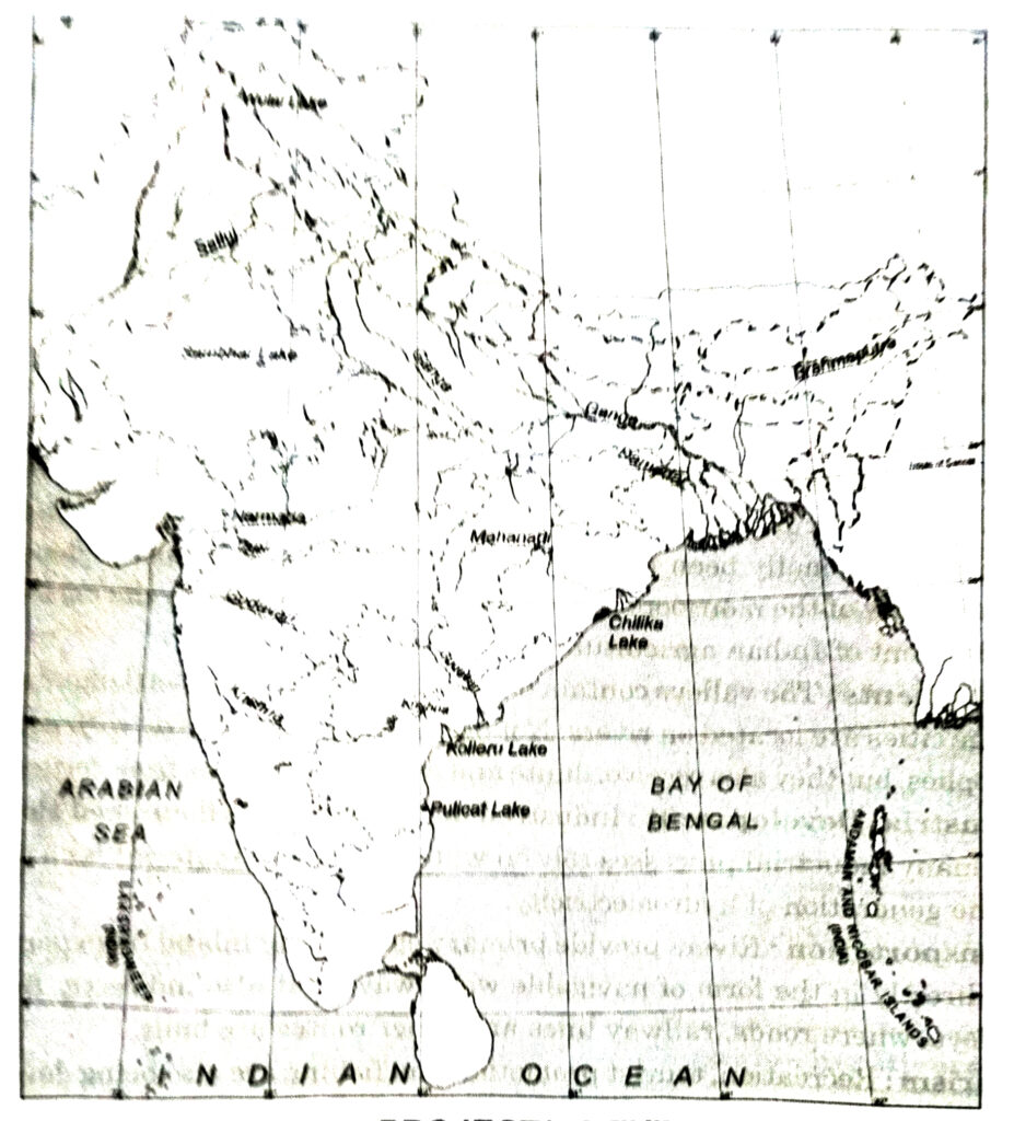
(i) On an outline map of India mark and label the following rivers: Ganga, Satluj, Damodar, Krishna, Narmada, Tapi, Mahanadi and Brahmaputra.
(ii) On an outline map of India mark and label the following lakes: Chilika, Sambhar, Wular, Pulicat, Kolleru.
Ans.—
PROJECT/ACTIVITY
Solve this crossword puzzle with the help of given clues.
Across
1. Nagarjuna Sagar is a river valley project. Name the river.
2. The longest river of India.
3. The river which originates from a place known as Beas Kund.
4. The river which rises in the Betul district of M.P. and flows westwards.
5. The river which is known as the “Sorrow” of West Bengal.
6. The river on which the reservoir for Indira Gandhi canal has been built.
7. The river whose source lies near Rohtang Pass.
8. The longest river of Peninsular India.
Down
9. A tributary of Indus originating from Himachal Pradesh.
10. The river flowing through fault, drains into the Arabian Sea.
11. Ariver of south India, which receives rain water both in summer and winter.
12. A river which flows through Ladakh, Gilgit and Pakistan.
13. An important river of the Indian desert.
14. The river which joins Chenab in Pakistan.
15. A river which rises at Yamunotri glacier.
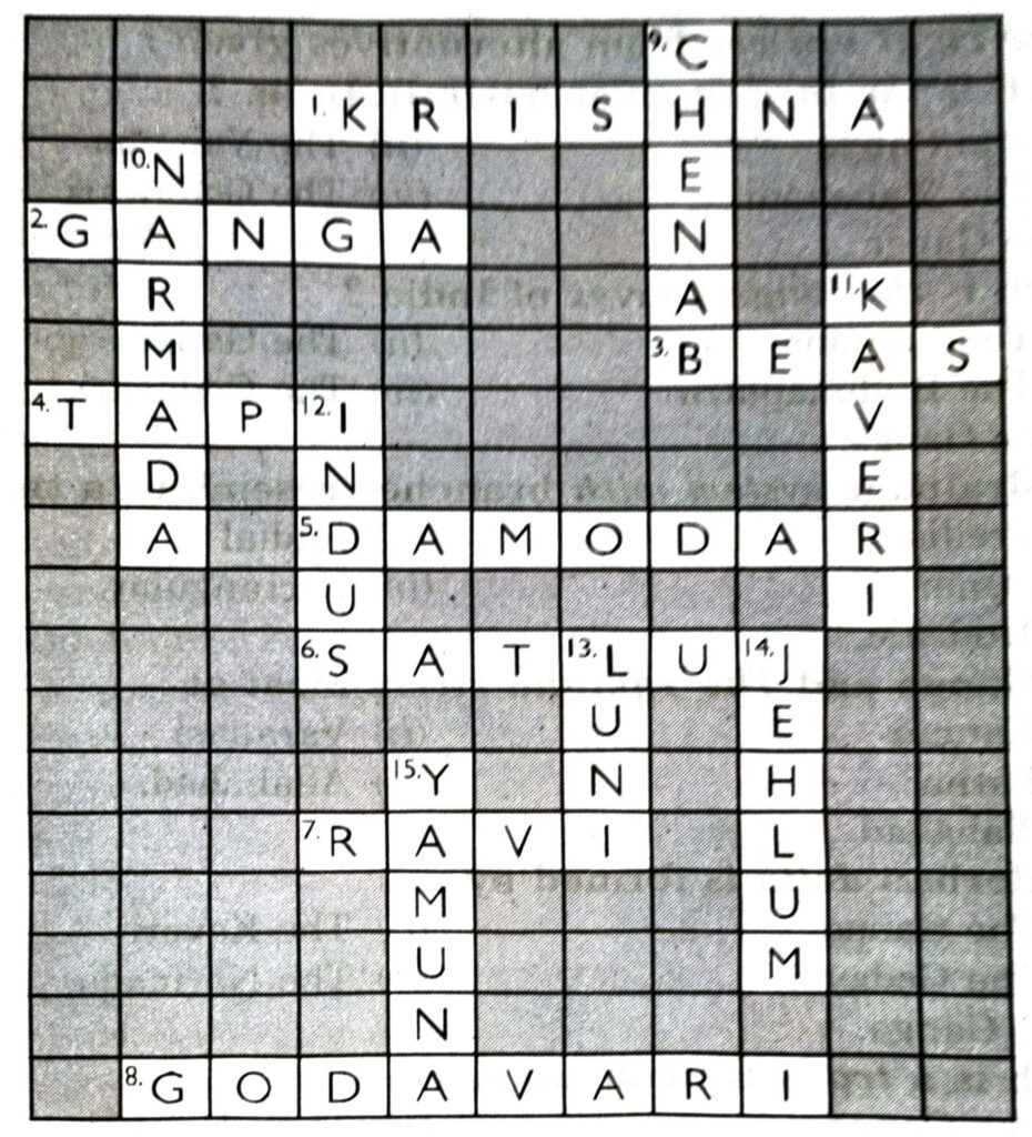
Ans.— Across: 1. Krishna; 2. Ganga; 3. Beas; 4. Tapi; 5. Damodar; 6. Satluj; 7. Ravi; 8. Godavari. Down: 9. Chenab; 10. Narmada; 11. Kavari; 12. Indus; 13. Luni; 14. Jhelum; 15. Yamuna.
OTHER IMPORTANT QUESTIONS
Objective Type Questions
l. Multiple Choice Questions
SET-I
Choose the right answer from alternatives given :
Q. 1. Which is the largest river basin in India ?
(i) The Ganga
(ii) The Yamuna
(iii) The Mahanadi
(iv) The Godawari.
Ans.— (i) The Ganga.
Q. 2. Which is the longest river of India ?
(ii) The Yamuna
(ii) The Ganga
(iii) The Brahmaputra
(iv) The Godavari.
Ans.— (ii) The Ganga.
Q. 3. The drainage system with branches resembles a tree :
(i) Trellis
(ii) Radial
(iii) Dendritic
(iv) Rectangular.
Ans.— (iii) Dendritic.
Q. 4. The Ganga and The Yamuna rivers meet at :
(i) Kanpur
(ii) Varanasi
(iii) Patna
(iv) Allahabad
Ans.— (iv) Allahabad.
Q. 5. Sunderban delta is formed by :
(i) The Ganga
(ii) The Kaveri
(iii) The Godavari
(iv) The Narmada.
Ans.— (i) The Ganga.
Q. 6. Which is a trans Himalayan river ?
(i) The Ganga
(ii) The Chambal
(ii) The Sutlej
(iv) The Beas.
Ans.— (iii) The Sutlej.
Q. 7. Which river is called Dakshin Ganga ?
(i) Mahanadi
(ii) Godavari
(iii) Krishna
(iv) Cauvery.
Ans.— (ii) Godavari.
Q. 8. Where is Dal lake located ?
(i) In Arunachal
(ii) In Kerala
(iii) In J & K
(iv) In Rajasthan.
Ans.— (iii) In J & K.
SET-II
Q. 1. The world’s largest drainage basin is :
(i) Amazon Basin
(ii) Nile Basin
(iii) Ganga Basin
(iv) Indus Basin.
Ans.— (ii) Nile Basin.
Q. 2. The river on which Bhakra Dam has been constructed :
(i) Ravi
(ii) Beas
(iii) Sutlej
(iv) Sutlej
Ans.— (iii) Sutlej.
Q. 3. Which river flows through a rift valley ?
(i) Narmada
(ii) Tapti
(iii) Godavari
(iv) Sone.
Ans.— (ii) Tapti.
Q. 4. Which river rises from Yamontri glacier ?
(i) Ganga
(ii) Yamuna
(iii) Gandak
(iv) Kosi.
Ans.— (ii) Yamuna.
Q. 5. The length of Indus River is :
(i) 2700 km
(ii) 2800 km
(iii) 2900 km
(iv) 3000 km.
Ans.— (iii) 2900 km.
Q. 6. Which is the southern tributary of Yamuna river ?
(i) Chambal
(ii) Sone
(iii) Luni
(iv) Damodar.
Ans.— (i) Chambal.
Q. 7. The length of Ganga is :
(i) 2200 km
(ii) 2400 km
(iii) 2500 km
(iv) 2600 km
Ans.— (iii) 2500 km.
II. Fill in the Blanks
1. ……… river is called sorrow of Bengal.
2. River Indus rises in ………………
3. ………. is the largest river basin in India.
4. The Ganga and Yamuna rivers meet at ………. .
5. The length of Ganga river is …………. .
6. ………. basin is the world’s largest drainage basin.
7. ……….. formed the sunderbans delta.
8. ……….. lake is a lagoon lake.
Ans.—1. Damodar, 2. Tibet, 3. The Ganga, 4. Allahabad, 5. 2500 km. 6. Nile, 7. The Ganga, 8. Chilika.
III. True/False
1. Godavari is the largest river in Peninsular India.
2. Indus treaty was formed in 1960.
3. The total length of Indus river is 3000 km.
4. K₂ peak located in Karakoram mountains.
5. Rivers which have water throughout the year are seasonal rivers.
Ans.— 1. √, 2. √, 3. x, 4. √, 5. √.
Very Short Answer Type Questions
HIMALAYAN RIVERS
Q. 1. Name the three main Himalayan river systems.
Ans.— Indus, Ganga, Brahmaputra.
Q. 2. Name two salt water lakes on the eastern coast of India.
Ans.— Chilka lake and Pulicat lake.
Q. 3. What is the length of Ganga River ?
Ans.— 2500 kms.
Q. 4. Name an area in Tibet from where three main rivers (Indus, Sutlej and Brahmaputra) rise.
Ans.— Mansarovar Lake.
Q. 5. What is the total length of Indus river ?
Ans.— 2900 km.
Q. 6. Name the water treaty between India and Pakistan.
Ans.— Indus water treaty.
Q. 7. Name the place where Yamuna joins Ganga river.
Ans.— Allahabad.
Q. 8. What name is given to Ganga-Brahmaputra Delta ?
Ans.— Sunderbans.
Q. 9. What name is given to Brahmaputra river in Tibet ?
Ans.— Tsangpo.
Q. 10. Where do the rivers Indus and Ganga have their origin.
Ans.— The river Indus rises near lake Mansarovar and the Ganga originates at the Gangotri glacier. Both of them have their origin in the Himalayas.
Q. 11. Name the place where Yamuna joins Ganga River ?
Ans.— Triveni Sangam in Allahabad is the actual confluence of rivers Yamuna & Ganga.
PENINSULAR RIVERS
Q. 12. Name a peninsular river forming an estuary.
Ans.— Narmada.
Q. 13. Name the largest river in Peninsular India.
Ans.— Godavari.
Q. 14. Name the largest fresh water lake in India.
Ans.—. Wular lake.
Q. 15. Where does the Narmada river rise ?
Ans.— Amarkantak.
Q. 16. Which river is called vridha Ganga or Dakshir Ganga ?
Ans.— Godavari River.
Q. 17. Name a lagoon lake.
Ans.— Chilka lake.
RIVERS OF J&K
Q.1. Which is the main river of J&K ?
Ans.— Indus.
Q. 2. Name three rivers of J&K.
Ans.— Jhelum, Chenab, Ravi.
Q. 3. Name two tributaries of Indus river.
Ans.— Zanskar and shyok.
Q. 4. Which rivers from India join Indus ?
Ans.— Ravi, Beas, Sutlej.
Q. 5. What is the total length of Indus river ?
Ans.— 2900 km.
Q. 6. When was Indus treaty formed ?
Ans.— In 1960.
Q. 7. Chenab is formed by which too rivers ?
Ans.— Chander-Bhagga.
Short Answer Type Questions
Q. 1. What do you mean by Trans-Himalayan rivers ? Give three examples from India.
Ans.— Trans-Himalayan river means a river rising beyond the great Himalayas. After cutting deep gorges in the great Himalayas, the river flows into Indian subcontinent. Indus, Satlej and Brahmaputra are three trans-Himalayan rivers. (i) The Indus flows parallel to great Himalayas and turns southward. (ii) Similarly, the Brahmaputra flows parallel to Himalayas in Tibet and takes a bend in Arunachal Pradesh. (iii) The Sutlej making a deep gorge flows over Punjab plains.
Q. 2. What do you mean by a drainage basin ?
Ans.— Rivers flow in the direction of slope of an area. Small streams (tributaries) flowing from different directions come together to form the main river. The main river flows into a lake a, sea or an ocean. The area drained by a single river system is called a drainage basin or river basin.
Q. 3. Why is Godavari river often referred to as ‘Dakshina Ganga’ or Vridha Ganga ?
Ans.— The Godavari is the longest of the Peninsular rivers. It has an extensive drainage basin. Its drainage basin extends through Maharashtra, Madhya Pradesh, Karnataka, Orissa and Andhra Pradesh. Because of its large size and extent, it is compared to river Ganga. It has got the same cultural significance in the peninsular India as the Ganges has in the northern plain. Therefore it is referred to as Dakshina Ganga or Vridha Ganga.
Q. 4. State four characteristics of Himalayan rivers.
Ans.—Main Characteristics. (i) These rivers have large basins. (ii) These make deep gorges. (iii) These were formed due to down cutting during period of uplift of Himalayas. (iv) These are perennial rivers as these get water from rainfall and from the melting of snow. (v) These deposit silt and sand to form plains.
Q. 5. Why are the rivers considered the lifelines of human civilisation ?
Ans.— A river is an important part of land. (i) It carries water, sediments and dissolved minerals. (ii) Estuaries are important fishing grounds. (iii) The early man developed the occupations of hunting and gathering along the river banks. (iv) Water is necessary for pastoral and agricultural activities. (v) Towns are located on the banks of rivers. These serve as waterways and means of commerce. These generate water power. These provide canal irrigation. The earliest civilisations like Indus and Egyptian settled along the banks of rivers. So rivers are called the lifelines of human civilisation.
Q. 6. What is a Lake ? How many types of lakes are there ? Give some examples.
Ans.— A lake is a body of water lying on a hollow earth’s surface. It is surrounded by land on all sides. There are two types of lakes-fresh and saline. There are two more types of lakes-natural and man-made as Wular lake, Dal lake, in Kashmir, Sambhar Salt lake in Rajasthan, Chilka lake and Pulicat lake on the eastern coasts. Many man-made lakes have been built across the rivers by constructing dams.
Q. 7. What do you know about Pollution of rivers ?
Or
Write a short note on Pollution of rivers.
Ans.— River water is used for farming, drinking, domestic and industrial uses. The demand for water is increasing due to :
(i) Growing population (ii) Urbanisation (iii) Industrialisation.
But the rivers are being polluted due to load of untreated sewage and effluents. About 20 towns along the banks of Ganga river have been suffering from water pollution. So Ganga Action Plan had been started in 1980 to clean the Ganga river.
Q. 8. Where does the river Indus rise ? Name its five important tributaries.
Ans.— The river Indus rises in Tibet at an altitude of 5180 metres near Mansarovar lake. It is a trans-Himalayan river. It flows West and NorthWestwards and reaches the Arabian Sea. Its five important tributaries are Jhelum, Chenab, Ravi, Beas and Sutlej.
Q. 9. Why do the rivers have no deltas on the Western Coast, even though they transport lot of sediments with them ?
Ans.— The Narmada and Tapti are the main rivers flowing westward on the western coast. These rivers carry a large amount of sediments with them. But these rivers do not form any delta near their mouths. These rivers form estuaries. (i) The west coasts are not marked with favourable conditions required for the formation of a delta. (ii) The lower courses of these rivers have steep slopes. (iii) The rivers have a swift current. The rivers are unable to deposit their sediments at their mouths. (iv) These rivers do not have any large tributaries to add to their sediments. (v) These rivers flow through rift valleys. Most of sediments are deposited in these troughs. Due to subsidence, deep estuaries are formed near their mouths. Thus these rivers have no deltas on the west coast due to lack of favourable physical conditions.
Q. 10. Distinguish between a Gorge and a Rift Valley.
Ans.—
| Gorgen | Rift Valley |
| 1. A gorge is a narrow, deep valley with steep walls formed by a river in hilly areas. | 1. A rift valley is a trough formed by sinking of land between two faults. |
| 2. A gorge is formed by rapid down cutting of the river bed. | 2. It is formed due to the forces of tension. |
| 3. Indus gorge, Sutlej gorge are good examples found in India. | 3. Narmada valley and Tapi valleys are rift valleys in India. |
Q. 11. Describe the Indus River System.
Ans.— (i) The Indus River System: The river Indus rises in Tibet, near Lake Mansarovar. (ii) Flowing west, it enters India in the Ladakh district of Jammu and Kashmir through a picturesque gorge. Several tributaries, the Zaskar, the Shyok Nubra and the Hunza, join it in this region. (iii) It flows through Baltistan and Gilgit and emerges from the mountains at Attock. The famous five rivers of Punjab-the Satlej, the Beas, the Ravi, the Chenab and the Jhelum enter the Indus a little above Miankot in Pakistan. Beyond this, the Indus flows southwards eventually reaching the Arabian Sea, east of Karachi. (iv) The total length of the river is about 2900 km, ranking it amongst the longest rivers of the world. (v) A little over a third of the Indus basin is located in India in the states of Jammu and Kashmir, Himachal Pradesh and the Punjab and the rest is in Pakistan.
Q. 12. Write a note on National River Conservation Plan (NRCP) and Ganga Action Plan (GAP).
Ans.— National River Conservation Plan (NRCP)
The activities of Ganga Action Plan (GAP) Phase-I, initiated in 1985, were declared closed on 31st March 2000. The Steering Committee of the National River Conservation Authority reviewed the progress of the GAP and necessary correction on the basis of lessons learnt and experiences gained from GAP Phase-I. These have been applied to the major polluted rivers of the country under the NRCP.
The Ganga Action Plan (GAP) Phase-II, has been merged with the NRCP. The expanded NRCP now covers 152 towns located along 27 interstate rivers in 16 states. Under this action plan, pollution abatement works are being taken up in 57 towns. A total of 215 schemes of pollution abatement have been sanctioned. So far, 69 schemes have been completed under this action plan. A million litre of sewage is targeted to be intercepted, diverted and treated.
Long Answer Type Questions
Q. 1. Describe the main rivers of Northern India in details.
Ans.— Drainage systems of India : India’s agricultural economy depends upon rivers. India has been often called a ‘land of rivers’. Vindhyas act as a water divide between the rivers of Northern India and the Peninsular India.
DRAINAGE SYSTEM OF NORTHERN INDIA
This drainage system extends from Punjab to Assam and is divided into three systems :
1. The Indus System
2. The Ganges System
3. The Brahmaputra System.
1. The Indus Drainage System : It is one of the world’s largest systems. The river Indus rises in Tibet near lake Mansarovar and enters India in Ladakh. It comprises the rivers of India, Jhelum, Chenab, Ravi, Sutlej and Beas. Indus, Jhelum and Chenab flow in Pakistan. .
2. The Ganga Drainage System : The Ganga is the most sacred river of India. The story of the Ganga from her source to the sea, from old times to new is the story of India’s civilisation and culture. The Ganga has its source near Gomukh glacier, near Gangotri. The Ganga is formed by two head streams namely Alaknanda and Bhagirathi. It enters the plains near Haridwar. The Yamuna meets this river at Allahabad known as Sangam.
3. The Brahmaputra System : The Brahmaputra river is the master stream of this system. It is 2880 km long. It flows parallel to the Himalayas in Tibet and is known as Tsangpo. It enters India in Arunachal Pradesh through Dihang gorge. It is known for its notorious floods and silt deposits. It joins Padma river in Bangladesh to form a large delta.
Q. 2. Describe the main rivers of Peninsular India.
Ans.— The drainage system of peninsular India :
Most of the peninsular rivers are seasonal. These flow through narrow, deep valleys. These rivers can be divided into two categories :
(i) Rivers falling into the Arabian Sea.
(ii) Rivers falling into the Bay of Bengal.
(a) Rivers falling into the Arabian Sea :
1. The Narmada : It rises from Amarkantak Plateau in Madhya Pradesh. It flows through a rift valley between the Vindhyas and Satpuras. Kapildhara falls, Marble rocks and Dhuandhar falls are important. It does not form a delta on the western coast.
2. The Tapti : It rises near Betul in Mahadeo Hills. It is 724 km long. It flows. through a rift valley. Looni, Sabarmati and Mahi are other main rivers falling into the Arabian Sea.
(b) The rivers falling into the Bay of Bengal :
1. Damodar River : The Damodar, 530 km long, rises from Chotta Nagpur plateau. On account of its floods, it is called ‘River of Sorrow’. D.V.C. Project is a multipurpose project to get benefits from this river.
2. The Mahanadi : It is 857 km long. It emerges from Amarkantak Plateau, It is a navigable river and forms a fertile delta.
3. The Godavari : It is 1440 km long and rises from the Western Ghats. It is the longest river of the Peninsula. It forms a fertile delta on the East Coast.
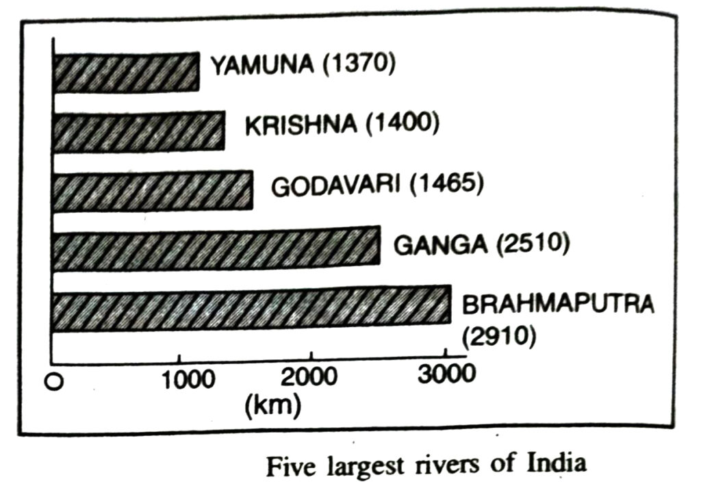
4. The Krishna : It is 1400 km long. It rises near Mahabaleshwar in Western Ghats. Its tributaries-Bhima and Tungbhadra are important.
5. The Kavery : It rises in Brahmgiri in the Coorg district. It is 800 km long. It is useful for irrigation, navigation and water power development. The famous forms a fertile delta on the East Coast.
Q. 3. Describe the different types of lakes found in India.
Ans.— LAKES :
A depression on the surface of the earth, where water collects, is known as a lake. Lakes of greater size are called the seas, like the Caspian, the Dead and the Aral seas. Lakes are of two types :
(a) Permanent, (b) Seasonal
Although most lakes are permanent, some maintain the water flow only during the wet season, like the lakes in the basins of inland drainage of semi-arid regions.
1. Glaciar Lakes : A majority of lakes are the result of the action of glaciers and ice sheets, while the others have been formed by wind, river action, and human activities. Valley glaciers and ice sheets carve out hollows and troughs on the surface of the earth, which may later fill with water to form lakes, e.g. Wular and the Dal lake in Jammu and Kashmir.
2. Lakes in arid regions : Wind deflation also produces extensive depression in arid regions. These depressions if extended below the water table, a lake would be formed e.g. Gadisar lake in Jaisalmer.
3. Ox-bow Lakes : A meandering river across a flood plain forms cut-offs that later develop into an ox-bow lake.
4. Lagoons : Spits and bars form lagoons in the coastal area, like the Chilka Lake (Orissa), the Pulicat Lake (Tamil Nadu), the Kolleru Lake (Andhra Pradesh).
5. Saline Lakes : Lakes in the region of inland drainage are sometimes seasonal, for example, the Sambhar lake in Rajasthan, which is a salt water lake.
6. Dam Lakes : The damming of the rivers for the generation of hydel power has also led to the formation of a Lake like water reservoir e.g. Guru Gobind Sagar (Bhakra Nangal Project).
Q. 4. Describe the different drainage patterns.
Ans.— The streams of an area form patterns. These drainage patterns depend upon :
(i) Relief of Area.
(ii) Structure of Area.
(iii) Climatic conditions of Area.
The streams form the following patterns :
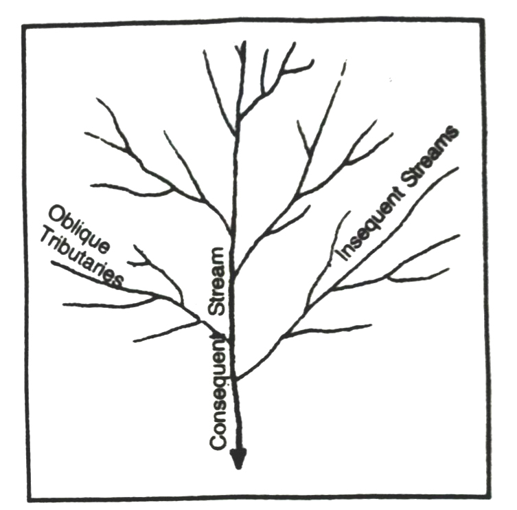
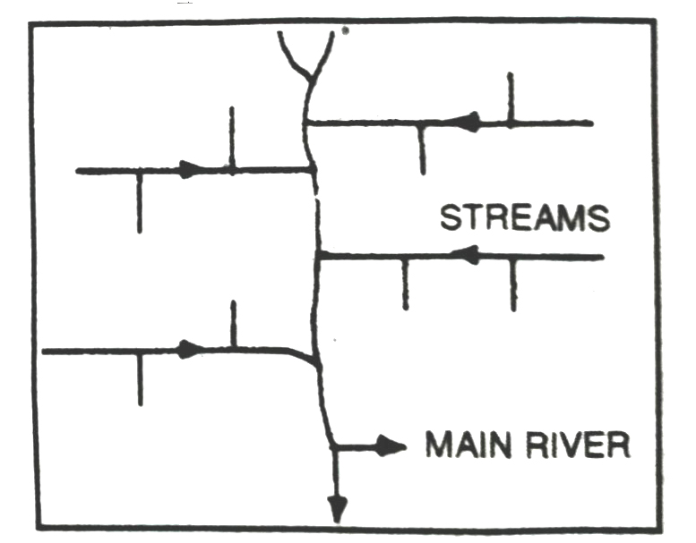
1. Dendritic pattern : It consists of a single main stream. The tributaries resemble the branches of a tree. These follow the slope of the area. Ganga river forms a dendritic pattern. The word dendritic is derived from Greek word dendron meaning tree.
2. Trellis pattern : In this the main stream is joined by short flowing streams. These streams join the main stream at right angles. It makes a rectangular pattern. Narmada river makes a Trellis pattern.
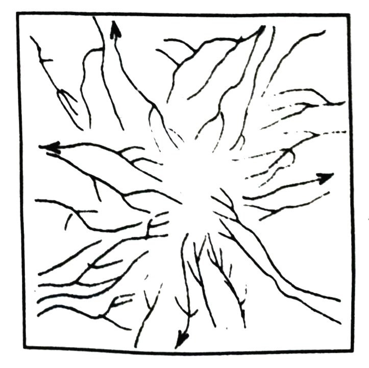
3. Radial pattern : In this, the stream flows in different directions from a central peak or dome like structure.
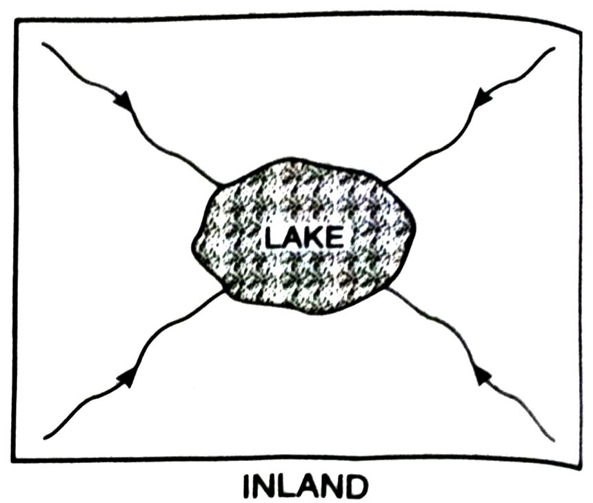
4. Inland drainage : In this pattern, the river does not reach an ocean. It falls into a lake or an inland sea. It is formed in desert at Rajasthan.
5. Rectangular pattern : It is developed on a strongly joined terrain. The drainage follows the joint patterns.
Q. 5. Describe the major rivers of J&K.
Ans.— Major rivers of J&K. The main rivers of J&K are Indus, Jhelum and Chenab.
The Indus River System
The river Indus rises in Tibet near lake Mansarovar. Flowing west, it enters India in the Ladakh, district of Jammu and Kashmir. It forms a picture show gorge in this part. Four main tributaries join it in Kashmir region.
(i) The Zanskar
(ii) The Nubra
(iii) The Shyok
(iv) The Hunza.
The indus flows through a gorge in Gilgit and emerges from the mountains at attock.
Other Tributries :
The Satlej, Beas, the Ravi, the Chenab and Jhelum join together to enter the Indus near Mithaukot in Pakistan. It has total length of 2900 km. The Indus is one of the longest rivers over the world. A little over a third of Indus Basin is in the territory of J&K and state Himachal Pradesh, the Punjab and rest in Pakistan.
The River Jehlum
The Jehlum (Vyeth in Kashmiri and Vitasta in Sanskrit) is the main waterway of valley of Kashmir. It rises from a spring called Verinag in Pir Panjal range. It flows to a distance of about 25 km upto Khanabal like a nallah and then is joined by various tributaries like Sandran, the Bringa, Vishew the Kokernag and the Achabal streams. River Lidder is also one other important tributary of the river Jehlum. The city Srinagar is situated on the banks of river Jehlum. At Baramula it enters through a Gorge and leaves the territory of India and enters Pakistan.
The River Chenab. The river Chenab is formed of two main streams the Chandra and the Bhaga. They rise in Lahul (HP) and is called Chanderbhaga before entering the territory of J&K. It enters J&K through Paddar region in Kishtwar. The total length of Chenab in J&K is about 118 km. Its basin spreads over an area of about 26755 sq. km. It drains the districts of Kishatwar Doday Ramban, Reasi and Jammu.
MAP SKILLS
Q. 1. On an outline map of India mark and label the following rivers :
(i) Ganga
(ii) Satluj
(iii) Damodar
(iv) Krishna
(v) Narmada
(vi) Tapi
Ans.—
Q. 2. On an outline map of India mark and label the following lakes :
(i) Sambhar (ii) Wular (iii) Pulicat (iv) Kolleru (v) Dal (vi) Hira kund (vii) Nainital (viii) Gobined Sagar
Ans.—
PROJECT/ACTIVITY
Across
1. Nagarjuna Sagar is a river valley project. Name the river.
Ans.— Krishna.
2. The longest river of India.
Ans.— The Ganga.
3. The river which originates from a place knwon as Beas Kund.
Ans.— The Beas.
4. The river which rises in the Betul district of M.P. and flows westwards.
Ans.— The Tappti.
5. The river which is known as the “Sorrow” of Bihar.
Ans.— The Kosi.
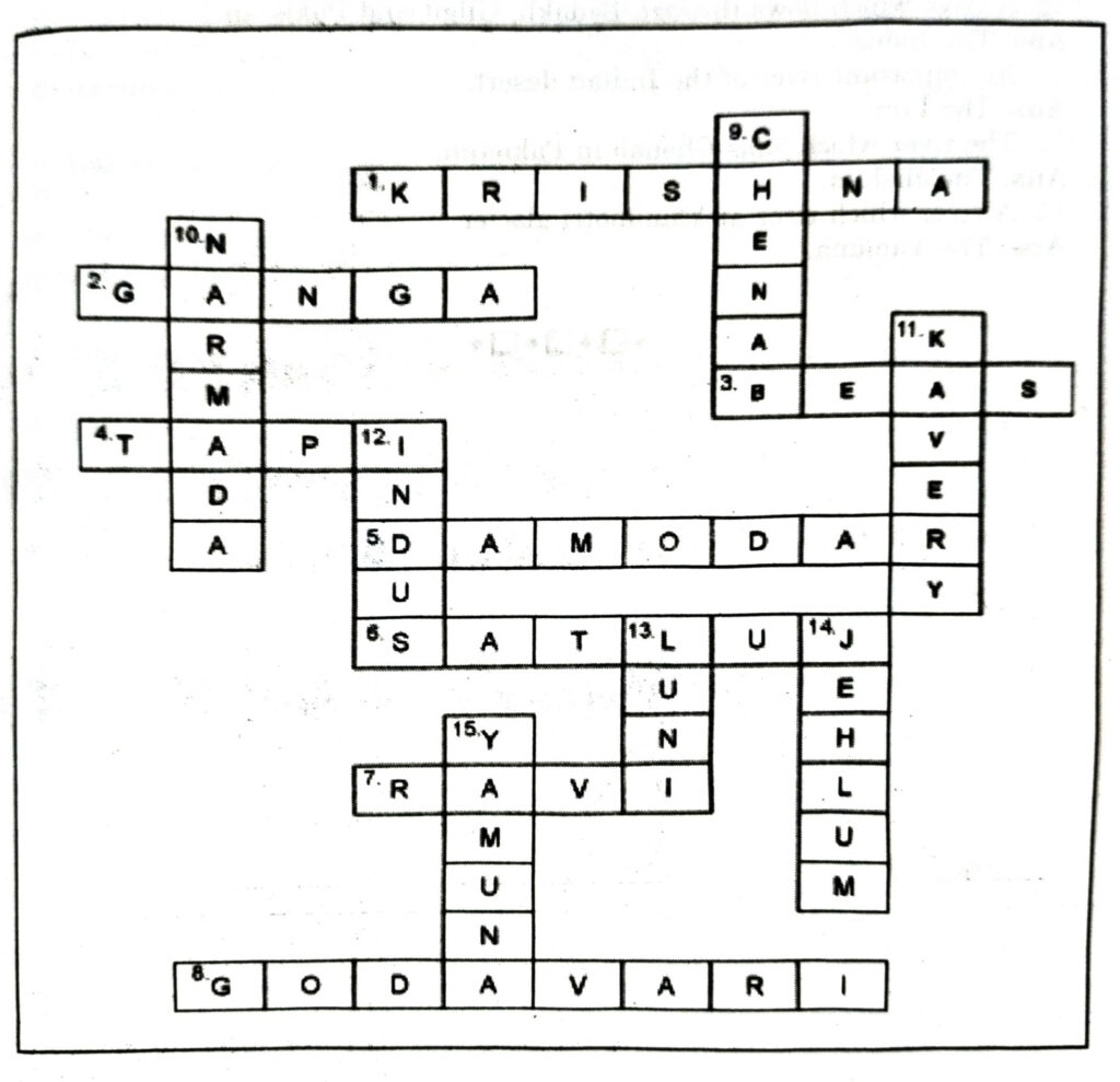
6. The river on which the reservoir for Indira Gandhi canal has been built.
Ans.— The Satlej.
7. The river whose source lies near Rohtang Pass.
Ans.— The Ravi.
8. The longest river of Peninsular India.
Ans.— The Godavari.
Down
9. A tributary of Indus originating from Himachal Pradesh.
Ans.— The Chenab.
10. The river flowing through fault, drains into the Arabian Sea.
Ans.— The Narmada. idaust
11. A river of south India, which receives rain water both in summer and winter.
Ans.— The Kaveri.
12. A river which flows through Ladakh, Gilgit and Pakistan.
Ans.— The Indus.
13. An important river of the Indian desert.
Ans.— The Luni.
14. The river which joins Chenab in Pakistan.
Ans.— The Jhelum.
15. A river which rises at Yamunotri glacier.
Ans.— The Yamuna.
Follow on Facebook page – Click Here
Google News join in – Click Here
Read More Asia News – Click Here
Read More Sports News – Click Here
Read More Crypto News – Click Here