JKBOSE 9th Class Social Science Solutions Chapter 4 Climate
JKBOSE 9th Class Social Science Solutions Chapter 4 Climate
JKBOSE 9th Class Social Science Solutions Chapter 4 Climate
Jammu & Kashmir State Board JKBOSE 9th Class Social Science Solutions
J&K class 9th Social Science Climate Textbook Questions and Answers
MAIN POINTS
● Climate of India—Tropical Monsoon type.
● Highest Temperatures—Barmer (Rajasthan) 50°C.
● Lowest Temperatures—Kargil (Ladakh)-45°C.
● Rainiest place—Mawsynram -1140 cms annual rainfall.
● Indian Ocean—Storehouse of moisture for monsoons.
● The Himalayas—A climatic divide.
● Jet Stream—A fast blowing wind at a high altitude.
● Monsoon—Derived from Arabic word ‘Mausim’.
● Seasons in India—Cold, Hot, Rainy and Retreating Monsoons.
● Western Disturbances—Cyclones from Mediterranean Sea. Give rainfall in N.W. India in winter.
● Mango Showers—Pre-monsoon rainfall around Karnataka.
● Kal Baisakh—Local thunder storms in Bengal and Assam.
● South-West Monsoons—1st June Date of onset in Kerala. Arabian Sea Branch and Bay of Bengal Branch.
● Rain Shadow Areas—Deccan Plateau, N.W. Kashmir, Shillong Plateau.
● North-East Monsoons—Retreating Monsoons (OctoberNovember).
—Give rainfall on the East coast
GEOGRAPHICAL TERMS
1. Climate : Climate is the sum total of weather conditions over a large area for a long time.
2. Weather : Weather is actual atmospheric conditions of a place for a short period.
3. Monsoons : Monsoons are seasonal winds.
4. Tropical zone : The area between the equator and the tropics.
5. Jet stream : Jet stream is a high velocity wind blowing in upper air.
6. Loo : Loo is hot dry wind blowing in summer.
7. Cyclones : An area of low pressure surrounded by high pressure.
8. Western disturbances : Shallow cyclones blowing over N.W. India during winter.
9. Rain Shadow : Dry area on the leeward slope.
10. Burst of Monsoons : The sudden on-set of Monsoons.
11. Mango Showers : Pre-monsoonal rainfall in Karnataka.
12. Kal Baisakh : Local thunder storms in Bengal and Assam.
13. Mawsynram : The rainiest place of the world.
14. Coriolis force : A force which deflects winds.
15. ITCZ : Inter Tropical Convergence Zone.
TEXTUAL QUESTIONS
Q. 1. Choose the correct answer from the four alternatives given below.
(i) Which one of the following places receives the highest rainfall in the world ?
(a) Silchar
(b) Mawsynram
(c) Cherrapunji
(d) Guwahati
Ans.— (b) Mawsynram.
(ii) The wind blowing in the northern plains in summer is known as :
(a) Kaal Baisakhi
(b) Loo
(c) Trade winds
(d) None of these
Ans.— (b) Loo.
(iii) Which one of the following causes rainfall during winters in north western part of India ?
(a) Cyclonic depression
(b) Retreating Monsoons
(c) Western disturbances
(d) Southwest Monsoons
Ans.— (c) Western disturbances.
(iv) Monsoon arrives in India approximately in :
(a) Early May
(b) Early July
(c) Early June
(d) Early August
Ans.— (c) Early June.
(v) Which one of the following characterises the cold weather season in India ?
(a) Warm days and warm nights and
(b) Warm days and cold nights
(c) Cool days and cold nights
(d) Cold days and warm nights
Ans.— (c) Cool days and cold nights.
Q. 2. Answer the following questions briefly.
(i) What are the controls affecting the climate of India ?
Ans.— The climate of India is affected by the following geographical factors :
(a) Monsoon winds : India’s climate is controlled by the monsoon winds. In summers, monsoons are onshore winds. These winds cause most of the rainfall in the sub-continent. In winters, the monsoon winds blow from land to sea as N.E. Monsoons. These are dry winds.
(b) Extent of the country : India is a vast country. The northern part lies in the temperate region and experiences hot summers and cool winters. The southern nearer to the equator and has a hot season throughout the year.
(c) Location of the Himalayas : The Himalayas act as a climatic barrier. This mountain wall protects India from the cold winds of Central Asia from entering India during winter. The Himalayas check the onshore S.W. Monsoons and prevent escaping the sub-continent, thus causing rainfall.
(d) The Indian Ocean : India lies at the head of the Indian Ocean. S.W. Monsoons originate from this ocean in summer and cause rainfall over most of the country. Cyclones also originate over this ocean.
(e) The Western disturbances : The western disturbances (cyclones) originate from the Mediterranean Sea and enter India in winter. These provide rainfall in the N.W. parts of India in winter.
(f) Distance from the sea : The coastal areas experience maritime climate. These areas have equable climate. But the areas in the interior experience extreme or continental type of climate such as N.W. India.
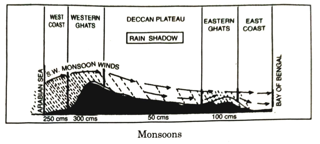
(g) Relief of the land : Relief influences the distribution of temperature and rainfall in India. Mountainous areas have low temperature. The windward slopes such as Western Ghats receive heavy rainfall while the leeward slopes (Deccan Plateau) lie in the Rain-shadow and are dry.
(ii) Why does India have a monsoon type of climate ?
Ans.— The Indian Sub-continent extends from 8° North to 37° North latitudes. So, it has a tropical location. The Himalayas provide an enclosed character to the sub-continent. The Indian Ocean in the South gives it a hot monsoon climate. As result, India has essentially a tropical monsoon climate. The Tropic of Cancer divides the country into two halves. The northern half lies in the temperate zone while the southern half lies in the tropical zone. Hence, India has high temperatures throughout the year and most of the rain takes place in summer.
(iii) Which part of India does experience the highest diurnal range of temperature and why ?
Ans.— The Thar desert has high diurnal or daily range of temperature. The difference between the daily maximum and daily minimum temperature is large. The sandy soils become heated during the day and cool down during the night.
(iv) Which winds account for rainfall along the Malabar Coast ?
Ans.— Malabar coast lies on the West Coast, facing the Western Ghats. The Arabian Sea branch of the monsoons are onshore moisture-laden winds and cause heavy rainfall on the western slopes of the Western Ghats and the West Coast. S.W. Monsoon winds first strike the Malabar coast causing heavy rainfall called a ‘monsoon burst’.
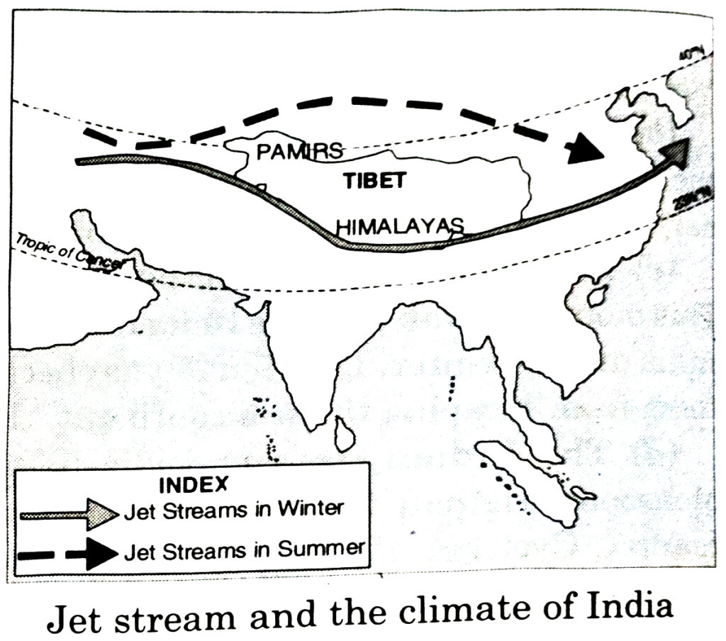
(v) What are Jet streams and how do they affect the climate of India ?
Ans.— Jet streams are fast flowing winds blowing in a narrow zone in the upper atmosphere. The Himalayas divide the jet streams into two parts. The westerly jet streams (27°-30° N) blows over the south of the Himalayas during the winter season. The easterly jet streams develop at about 14°N in summer. It is believed to be responsible for the sudden outbreak of monsoons in Northern India. It causes widespread storms, thunder and rainfall over India in just 8 to 10 days.
(vi) Define monsoons. What do you understand by ‘break’ in monsoon ?
Ans.— Monsoons are seasonal winds. These change their directions with the season. Monsoon starts all of a sudden and is called the break in monsoons.
(vii) Why is the monsoon considered a unifying bond ?
Ans.— There is a great diversity in climatic conditions of India due to differences in relief features.
Examples : (a) Due to monsoon winds, India has a monsoon type of climate throughout the country. (b) The whole country is influenced by the same order of seasons. (c) The monsoonal rhythm of seasons is a great unifying force in India. (d) Monsoons control the atmospheric conditions of the country. Throughout the country, the summers are wet and the winters dry due to onshore winds. The distribution of rainfall is uneven. (e) Agriculture depends upon monsoonal rainfall resulting in a subsistence agriculture. Agriculture in India is a gamble in monsoons. The folk songs like Kajari of Bhojpur and Malhar of Braj are associated with monsoonal rains. (g) Thus, monsoons provide a natural base for a uniformity throughout the country.
Q. 3. Why does the rainfall decrease from the east to the west in Northern India ?
Ans.— The Bay of Bengal branch of monsoons move from east to west. These move up the Ganga Valley along the Himalayas. As these winds move westward, these become drier and cause less rainfall. Kolkata gets an annual rainfall of 162 cm, Patna 102 cm, Allahabad 91 cm and Delhi gets 56 cm of rainfall.
Q .4. Give reasons as to why.
1. Seasonal reversal of wind direction takes place over the Indian subcontinent.
Ans.— Mechanism of Monsoons
The N.E. trade winds are replaced by the monsoons. The S.E. trade winds of the southern hemisphere after crossing the equator become S.W. monsoons. The dry and hot winds are replaced by wet monsoons during the summer seasons. The mechanism of the monsoon is from temperature, through pressure and winds to rainfall.
Due to high temperatures, a low pressure develops over the North-West part of India. This is basically responsible for the reversal of wind direction and rise of S.W. monsoons. Thus, it was originally thought that monsoons have a thermal origin and these are surface winds. But nowadays, the meteorological data has proved that upper air winds and currents also play an important role in the mechanism of monsoons. The jet streams also affect the mechanism of monsoons.
The eastern branch of jet streams is believed to be responsible for the sudden break of monsoons and cause heavy rainfall.
2. The bulk of rainfall in India is concentrated over a few months.
Ans.— The bulk of rainfall in India is received during the four months of the rainy season, i.e., June, July, August and September. This is the period of SouthWest monsoons blowing from sea to land. These sea to land winds are the rain giver, as these moisture-laden winds are onshore winds. The tropical cyclones add to the amount of rainfall. Easterly tropical jet streams, too, help in rains during this period.
3. The Tamil Nadu coast receives winter rainfall.
Ans.— The Konkan Coast faces the onshore S.W. monsoons during summer. These moisture-laden winds cause heavy rainfall (more than 300 cms). But these winds do not give much rainfall on the Coromandel Coast as it lies in the rain shadow area of the Western Ghats. The Coromandel Coast receives winter rainfall from N.E. monsoons, but on the Konkan Coast, these winds are offshore and do not give any rainfall. Thus, Coromandel Coast gets rainfall in both the seasons, but the total amount is less than that of Konkan Coast. Total rainfall in Chennai is 128 cms, but it is 180 cms at Mumbai.
Tamil Nadu gets most rain from North-East monsoons in October and November. These winds after picking up moisture from the Bay of Bengal give more rain on the East Coast. Thus, Tamil Nadu gets most rain in winter when the fury of monsoons is over in most parts of the country.
4. The delta region of the eastern coast is frequently struck by cyclones.
Ans.— Tropical cyclones are depressions originating over the Bay of Bengal. These tropical cyclones are often very destructive. They cause heavy rains. These cyclones strike West Bengal and Bangladesh (Ganga Delta). These cross the eastern coast and affect the states of Odisha, Andhra Pradesh, Tamil Nadu and Kerala. The thickly populated deltas of Mahanadi, Godavari, Krishna and Kaveri are their targets.
5. Parts of Rajasthan, Gujarat and the Leeward side of the Western Ghats are drought prone.
Ans.— The western part of Rajasthan is a desert. It gets an annual rainfall of less than 20 cms. This is due to the following reasons :
(a) Rajasthan is under the influence of the S.W. summer monsoons. The Aravallis system lies parallel to the direction of S.W. monsoons coming from the Arabian Sea. These low mountain system is unable to check these winds. So, western Rajasthan is practically dry. The southern parts get some rainfall.
(b) This area lies at a great distance from the Bay of Bengal. The Bay of Bengal monsoons become dry and lose their moisture when they reach Rajasthan.
(c) This area is away from the Himalayan region. So it does not come under the influence of monsoons, giving rain in the sub-Himalayan region.
(d) Gujarat has high variability of rainfall. So it is a drought prone area.
(e) The leeward slopes of Western Ghats is in rain shadow area.
Q. 5. Describe the regional variations in the climatic conditions of India with the help of suitable examples.
Ans.— Due to the vast size of India, many regional variations in climatic conditions are found. But due to the influence of monsoons, India has a broad unity of Monsoon type of climate having the same rhythm of season. Many factors like location, altitude, distance from the sea, general relief produce regional variations in pattern of winds, temperature and rainfall. The examples given below illustrate the climatic differences :
1. Temperature : Barmer (Rajasthan) has recorded the highest day temperatures of 50°C in summer, and 15°C at night, while hilly regions like Gulmarg (Kashmir) have a day temperature of 20°C in June. The winter temperatures at Dras and Kargil (Leh) drops as low as −45°C, on the other hand Chennai may record only 20°C in December. The annual range of temperature is about 12°C at Cochin while it is about 40°C in Punjab. Coastal regions have almost uniform temperatures throughout the year.
2. Rainfall : The striking differences are found in rainfall pattern. Mawsynram (Meghalaya) with an annual rainfall of 1140 cm is the rainiest place in the world, while Jaisalmer (Rajasthan) rarely gets more than 12 cm of annual rainfall and Leh gets only 10 cm rainfall. The Western coastal plain gets rain-storms while the Coromandel coast remains dry. When the Brahmaputra valley is submerged in floods, it brings drought in Bihar.
3. Monsoons : The dates of onset and withdrawal of monsoons differ in various parts. The west coast gets monsoons in the first week of June, while the interior parts like Punjab receive monsoons by the first week of July.
4. Seasons : The southern parts of the country have uniformly high temperatures throughout the year. There is no winter season in the south. On the other hand, seasonal extremes are found in the north. In summer, a heat wave is produced, called Loo whereas, a cold wave is felt in winter.
Q. 6. Discuss the mechanism of monsoons.
Ans.— Currently, the mechanism of the monsoon is a widely-studied subject globally. In the Indian subcontinent, the mountain barriers to the north guide the flow of the monsoon winds. The Western Ghats, too, play a similar role. To understand the mechanism of the monsoons. Certain factors are responsible for the cause of the wind-reversal.
(i) The less heat around the Arabian Sea is caused due to intensive heating during the premonsoon months.
(ii) The northernmost position of Inter-Tropical Convergence Zone (ITCZ) in summer, also known as the monsoon-trough during the monsoon season.
(iii) High Pressure on the Indian Ocean. The intensity and position of this highpressure area over the Indian ocean affects the Indian Monsoon.
(iv) The Tibetan high-level plateau gets intensely heated during summer, which results in strong vertical air currents and the formation of high pressure over the plateau at about a kilometre above the sea level.
(v) The movement of the westerly jet streams to the north of the Himalayas and the presence of the tropical easterly jet streams over the Indian peninsula during summer.
Q. 7. Give an account of weather conditions and characteristics of the cold seasons.
Ans.— The Cold Season : The cold season lasts from January to February.
1. Temperature : The sun is overhead at the Tropic of Capricorn. The Indian sub-continent has winter season. January is the coldest month. The southern parts have warm conditions (20°C) while low temperatures (10°C) are found in N.W. India and the Trans-Himalayan region of Jammu and Kashmir, which are the coldest parts of India. The minimum temp. of -40°C are recorded at Dras or Kargil (Ladakh).
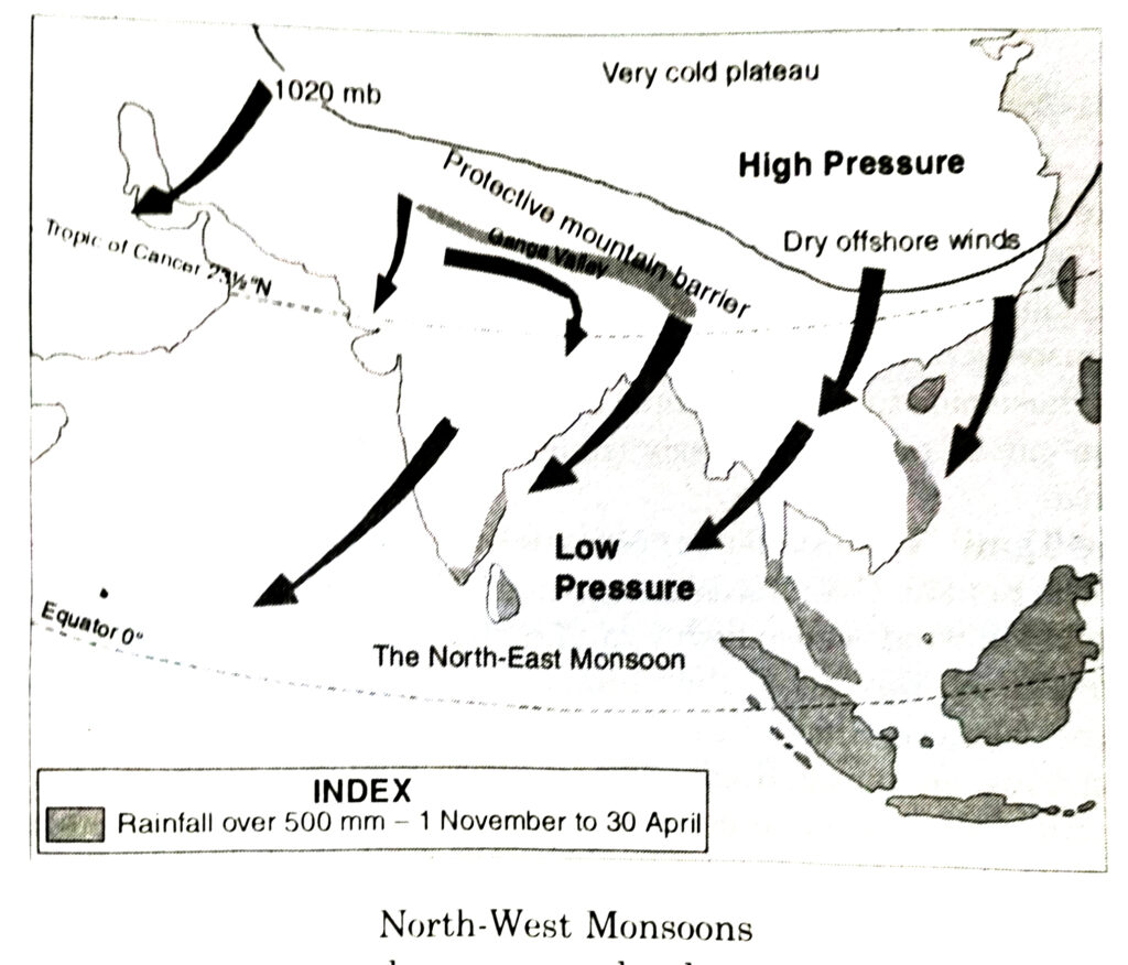
2. Pressure and Winds : High pressure developes over N.W. part, while a low pressure exists over the Indian Ocean. As a result, winds blow from land to sea.
3. Rainfall : The N.E. Monsoons being offshore winds are dry. But these winds pick up some moisture while crossing the Bay of Bengal and deliver rain to the S.E. coast of India. Some cyclones from the Mediterranean Sea cause rainfall (10-20 cm) on the Northern Plains. Leh receives snowfall.
Q. 8. Give the characteristics and effects of the monsoon rainfall in India.
Ans.— Characteristics of rainfall in India. The average annual rainfall in India is about 110 cms. It is estimated that more than 85% of this rainfall is received in summer. The main characteristics of summer rainfall are as follows :
1. Monsoonal rainfall : Most of the rain is received from the S.W. summer monsoons during the period mid-June to mid-September. It is seašonal rainfall.
2. Uncertain rainfall : Summer rainfall is quite uncertain. Some times monsoons start early resulting in floods. Often the onset of monsoons is delayed resulting in drought. The early or late retreat of monsoons also results in severe droughts.
3. Unequal distribution : The rainfall is unevenly distributed over the country. About 10% of the country gets more than 200 cm of rain while 25% of the country gets less than 75 cm of rain.
4. Heavy rainfall : Indian rainfall is heavy. It is often said that “It pours, it never rains in India.”
5. Relief rainfall : The amount of rainfall is determined by the presence of mountains. High mountains force monsoons to rise and cause rainfall. 6. No continuity of rainfall : Summer rain is characterised by breaks or dry spells.
7. Variable rainfall : Most of the areas have variable rainfall, as much as 30 cm plus or minus. Due to variability in areas of low rain, famines are formed.
MAP SKILL
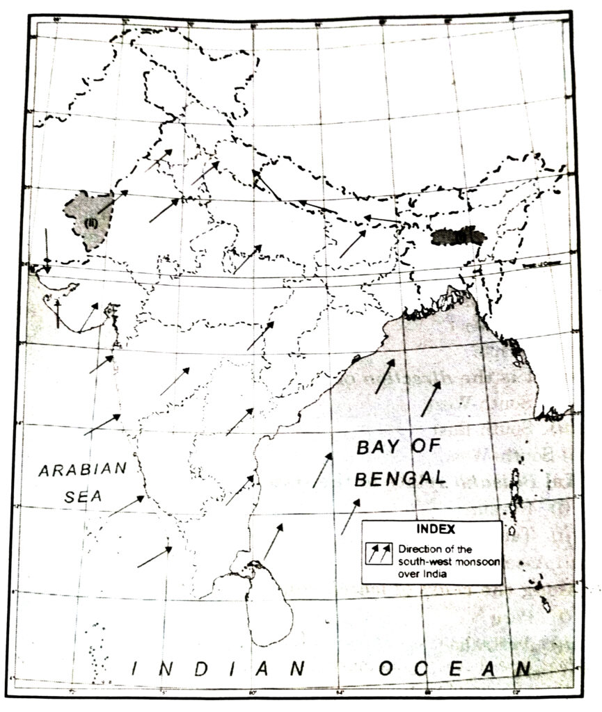
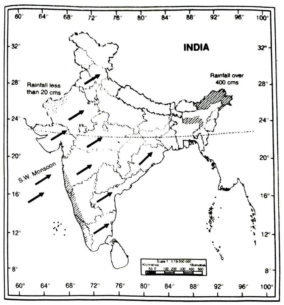
Q.1. On an outline map of India, show the following.
(i) Areas receiving rainfall over 400 cm.
(ii) Areas receiving less than 20 cm of rainfall.
(iii) The direction of the south-west monsoon over India.
Ans.—
PROJECT/ACTIVITY
(i) Find out which songs, dances, festivals and special food preparations are associated with certain seasons in your region. Do they have some commonality with other regions of India ?
Ans.— Try it yourself.
(ii) Collect photographs of typical rural houses, and clothing of people from different regions of India. Examine whether they reflect any relationship with the climatic condition and relief of the area.
Ans.— Try it yourself.
OTHER IMPORTANT QUESTIONS
Objective Type Questions
I. Multiple Choice Questions
SET-I
Choose the right answer from four alternatives given :
Q. 1. Which is the coldest place in India ?
(i) Srinagar
(ii) Shimla
(iii) Drass
(iv) Shillong.
Ans.— (iii) Drass.
Q. 2. Which is the hottest place in India ?
(i) Nagpur
(ii) Bangalore
(iii) Barmer
(iv) Kanpur.
Ans.— (iii) Barmer.
Q. 3. What is the direction of summer monsoons ?
(i) South-West
(ii) North-west
(iii) South-East
(iv) North-west
Ans.— (i) South-West.
Q. 4. Kal Baisakh relate to the state :
(i) Kerala
(ii) Assam
(iii) Tamil Nadu
(iv) Punjab.
Ans.— (ii) Assam.
Q. 5. Along the coast of which country, EL NINO flows ?
(i) Peru
(ii) South Africa
(iii) Australia
(iv) Europe.
Ans.— (i) Peru.
Q. 6. Which type of rainfall occurs in winter in N.W. plains of India ?
(i) Convectional
(ii) Relief
(iii) Cyclonic
(iv) Pre-monsoon.
Ans.— (iii) Cyclonic.
Q. 7. Winter cyclonic rainfall helps the growth of crop :
(i) Rice
(ii) Maize
(iii) Wheat
(iv) Cotton.
Ans.— (iii) Wheat.
Q. 8. Pre-monsoon rainfall is called in Karnataka ?
(i) Cyclonic
(ii) Kal Baisakh
(iii) Loo
(iv) Mango-showers
Ans.— (iv) Mango-showers.
Q. 9. Which station gets most of rainfall as snowfall ?
(i) Amritsar
(ii) Shimla
(iii) Leh
(iv) Kolkata
Ans.— (iii) Leh.
Q. 10. Which state suffers from Loo ?
(i) Madhya Pradesh
(ii) Tamil Nadu
(iii) Punjab
(iv) Gujarat.
Ans.— (iii) Punjab.
SET-II
Q. 1. What is the maximum temperature at Pehalgam in Summer ?
(i) 10°C
(ii) 15°C
(iii) 20°C
(iv) 25°C.
Ans.— (iii) 20°C
Q. 2. What is the minimum temperature at Drass in winter ?
(i) -10°C
(ii) -20°C
(iii) -35°C
(iv) -45°C.
Ans.— (iv) -45°C.
Q. 3. Most of India receives rainfall during months of :
(i) June to September
(ii) July to October
(iii) August to November
(iv) September to December.
Ans.— (i) June to September.
Q. 4. The rainfall is Ganga plains decreases from :
(i) East to West
(ii) West to East
(iii) North to South
(iv) South to North.
Ans.— (i) East to West.
Q. 5. In summer, a low pressure area develops over :
(i) N.W. India
(ii) Ocean
(iii) Eastern India
(iv) Over Southern India.
Ans.— (i) N.W. India.
Q. 6. Western Jet Stream belows over latitudes :
(i) 25-28° N
(ii) 26º-29°N
(iii) 27°-30°N
(iv) 28º-31°N
Ans.— (iii) 27°-30°N.
II. Fill in the Blanks
1. Monsoons are ……….. winds.
2. ……… is the wind blowing in the northern plains in summers.
3. …………. force deflects winds.
4. …………. is a high velocity wind blowing in upper air.
5. ………….. is the coldest place in J&K.
6. ………….. is called Pre-monsoon rainfall in Karnataka.
7. ………….. is a place in India records the highest rainfall in the world.
8. Jet stream blow at height of …………… .
Ans.— 1. Seasonal, 2. Loo, 3. Coriolis, 4. Jet stream, 5. Drass, 6. Mango shower, 7. Mawsynram, 8. 12000 metres.
III. True/False
1. Indian Ocean is called storehouse of moisture for monsoons.
2. Ladakh lies in rain shadow of Himalaya.
3. Barmer is the coolest place in India.
4. Cyclonic rainfall helps the growth by wheat crop.
5. Punjab state suffers from loo.
Ans.— 1. √, 2. √, 3. x, 4. √, 5. √.
Very Short Answer Type Questions
Q. 1. Name the elements of weather and climate.
Ans.— (1) Temperature (2) Atmospheric Pressure (3) Winds (4) Humidity (5) Precipitation.
Q. 2. What type of climate is found in India ?
Ans.— Tropical monsoon climate.
Q. 3. From which word is the term monsoon derived ?
Ans.— From Arabic word ‘Mausim.’
Q. 4. Which parallel of latitude passes through the middle of India ?
Ans.— Tropic of Cancer (231/2N).
Q. 5. Name the two climate zones formed by tropic of cancer.
Ans.— Tropical and sub-tropical.
Q. 6. Name the hottest place in India.
Ans.— Barmer (50°C) in Rajasthan.
Q. 7. Name the coldest place in India.
Ans.— Dras (- 45°C) (Jammu and Kashmir).
Q. 8. Which place in India records the highest rainfall in the world ?
Ans.— Mawsynram (Meghalaya).
Q. 9. Which part receives rainfall in winter due to western disturbances ?
Ans.— N.W. part of India.
Q. 10. Which part receives rainfall in winter due to North-East monsoons ?
Ans.— Tamil Nadu.
Q. 11. Which winds give most of rainfall in India ?
Ans.— South-west monsoons.
Q. 12. What are Jet Streams ?
Ans.— High velocity winds in upper air.
Q. 13. What do you mean by ‘Loo’ ?
Ans.— Hot dusty winds in summer.
Q. 14. What is meant by monsoon burst or breaking of monsoons?
Ans.— Sudden approach of S.W. monsoons.
Q. 15. Name a rain shadow area in India.
Ans.— Deccan Plateau.
Q. 16. What is the direction of summer monsoons ?
Ans.— South-West.
Q. 17. What is the direction of winter monsoons ?
Ans.— North-East.
Q. 18. Name the State which is the first to receive S.W. Monsoons.
Ans.— Kerala.
Q. 19. Which States experience Norwesters or Kal Baisakhi ?
Ans.— West Bengal and Assam.
Q. 20. Name a type of Pre-monsoon Rainfall.
Ans.— Mango-showers.
Q. 21. Name an area getting rainfall in both the seasons.
Ans.— Tamilnadu.
Q. 22. What is climate ?
Ans.— Average weather for a long time.
Q. 23. Name the coastal states struck by tropical cyclones.
Ans.— Tamilnadu, Andhra Pradesh, West Bengal and Orissa.
Q. 24. What is meant by Rain Shadow ?
Ans.— The leeward dry slope of a mountain.
Q. 25. Why most of the world’s deserts are located on the western margins of continents in the sub-tropics ?
Ans.— Due to cold currents on their coast.
Q. 26. What is Coriolis force ?
Ans.— A deflective force caused by Rotation.
Q. 27. Where are Jet streams located ?
Ans.— Over 27°-30° North latitude.
Q. 28. What name is given to winter rainfall in North-West plains ?
Ans.— Mahawat.
Q. 29. When do monsoons withdraw from Northern India ?
Ans.— By mid October.
Q. 30. What do you mean by Kal Baisakhi ?
Ans.— Violent Thunderstorms-calamity of the month of Baisakhi.
Q. 31. Expand ENSO.
Ans.— El Nino Southern Oscillations.
Q. 32. When is monsoon completely withdrawn from India ?
Ans.— By December.
Q. 33. Which deltas are struck by cyclones from Bay of Bengal ?
Ans.— Godavari, Krishna and Kaveri deltas.
Q. 34. Which region has high variability of rainfall ?
Ans.— Gujarat.
Q. 35. Why do S.E. Trades (South of Equator) become S.W. Monsoons after crossing equator ?
Ans.— Due to Ferral’s Law, these turn to the right.
Q. 36. At which height, does jet stream blow ?
Ans.— At 12000 metres.
Q. 37. What is the speed of Jet Stream ?
Ans.— 110 km per hour in summer and 184 km per hour in winter.
Short Answer Type Questions
Q. 1. What does the word ‘Monsoon’ imply ?
Ans.— The word ‘Monsoon’ is said to be derived from the Arabic word ‘Mausim’ meaning season. This word was first applied to the winds blowing over the Arabian Sea. Monsoon winds are those seasonal or periodic winds which change their direction with the season. These winds blow from sea to land for six months during summer and from land to sea for six months during winter.
Q. 2. Name the four seasons of India. Mention their months also.
Ans.— The meteorologists divide the calendar year into four main seasons as recognised in Indian weather.
(i) The Cold weather season—December to February
(ii) The Hot weather season—March to May
(iii) The Rainy season—June to September
(iv) The season of Retreating Monsoons—October to November.
Q. 3. Kanyakumari is the first to receive the S.W. monsoons and the last to see it retreat.
Ans.— The onset of monsoons begins on different dates in summer. These winds start at Thiruvananthapuram on Ist June, because Thiruvananthapuram lies nearer to Indian Ocean. Delhi an inland town and monsoons reach there on 25th June. So due to late arrival of monsoons, rains begin much later in Delhi.
Q. 4. Tamil Nadu coastal region receives most of the rain in winter. Why ?
Ans.— Tamil Nadu lies on the Coromandel Coast on the eastern coastal plain. This region receives rainfall in winter as well as summer. It receives most of the rainfall in winter.
(i) In summer, Tamil Nadu remains dry as this plain lies in the rain shadow of Western Ghats.
(ii) In winter N.E. Monsoons pick up moisture as these cross Bay of Bengal. These retreating monsoons are on-shore winds in Tamil Nadu plain. The Eastern Ghat forces these winds to give moderate rainfall in this area.
Q. 5. What do you understand by the term ‘Loo’ ?
Ans.— ‘Loo’ is a local wind. It is a very hot and dry wind which blows during the day time in Northern India. Loo increases the day temperatures ranging between 40° C to 50°C. The hot and dry winds are unbearable. These result in heat wave causing many deaths.
Q. 6. ‘Mawsynram receives the highest amount of rainfall in the world.’ Why ?
Ans.— Mawsynram is the rainiest place of the world with an average annual rainfall of 1140 cms. It is located on the southern slopes of Khasi Hills (Meghalaya) at a height of 1500 metres above sea level. This place is enclosed by hills on three sides. The relief features give this place a funnel shaped location. The Bay of Bengal of monsoons is trapped in these hills. These winds try to get out of it. These are forced to rise again and again resulting heavy rainfall.
Q. 7. Punjab and Haryana also receive rain in winter. Why ?
Ans.— Western disturbances are low pressure systems which originate in West Asia and the regions near Mediterranean Sea. These travel Eastwards across Iran and Pakistan and reach India during the winter season. These are active in winter in Northern India. On an average, four or five such depressions visit India each month. These give rainfall in areas of J&K, Punjab, Himachal Pradesh, Haryana and Rajasthan. The amount of rainfall decreases towards the East. This rainfall (20 mm-50mm) is useful for rabi crops especially wheat. In colder parts of Himachal Pradesh and J & K, these cyclones provide snowfall.
Q. 8. Rainfall decreases as one travels up the Ganges Valley. Why ?
Ans.— A branch of Summer Monsoon from Bay of Bengal moves up the Ganges Valley. It moves westwards along the Himalayas. The lower Ganges Valley receives the rainfall first, and the upper Ganges Valley later on. Kolkata has an annual rainfall of 162 cms. As the Branch of monsoons moves westward. It gets drier and drier. So it gives less rainfall. Patna gets 102 cms of rainfall, Allahabad 91 cms, Delhi gets 56 cms of rainfall.
Q. 9. Describe the distribution of rainfall in India.
Ans.—Distribution of rainfall
The average annual rainfall of India is 110 cms. Regional variations in the distribution are found due to differences in relief of the country. Rainfall is unevenly distributed throughout the country. India can be divided into the following rainfall regions :
1. Areas of Heavy Rainfall : These areas get more than 200 cms of annual rainfall. These include Western Coast and Western Ghats, Sub-Himalayas, and the N.E. Parts of India.
2. Areas of Moderate Rainfall : These areas get annual rainfall of 100-200 cms. These include West Bengal, Orissa, Bihar, Jharkhand, Eastern parts of U.P. and Madhya Pradesh, coastal plains of Tamil Nadu.
3. Areas of Low Rainfall : These areas experience an annual rainfall of 50-100 cms. These include Western part of U.P. Haryana, Punjab, Gujarat, Peninsular plateau and Eastern Rajasthan.
4. Areas of Scanty Rainfall : These areas get less than 50 cms of annual rainfall. These include Ladakh, S.W. Punjab, Southern Haryana, Western Rajasthan , Kutchh and Thar Desert.
Q. 10. Write two characteristics of Mango-showers and Kal Baisakh.
Ans.— (i) Mango-showers are actually pre-Monsoon showers. These are common in Kerala and coastal areas of Karnataka in the months of March and April.
(ii) These are locally known as Mango-showers because these help in the early ripening of mangoes. These are local storms which develop due to high temperatures.
Kal-baisakhs are local thunder storms experienced in the month of Baisakh (April) in West Bengal and Assam. The North-Westerly and Northerly winds which blow in the N.E. part of India cause very sharp showers in this region. These winds are called Norwesters. These cause evening thunder storms which
cause havoc in these parts. The word Kal-baisakh is local name for these storms. It means Kal = calamity, Baisakh month of Baisakh (calamity of the month of Baisakh).
Q. 11. Leh has moderate precipitation almost throughout the year. Give reasons.
Ans.— Leh (Ladakh) is located north of Great Himalayas. It gets rainfall as well as snowfall throughout the year due to height and northern cold winds. Annual rainfall is only 10 cms. Winter cyclones also give snowfall. Summer has less rainfall because it lies in rain shadow.
Q. 12. ‘Monsoons are called seasonal winds’. Why ?
Ans.— Monsoons are called seasonal winds as :
(i) They reverse their direction according to seasons particularly in summer and winter.
(ii) Great uncertainty is associated with these winds and are therefore seasonal in nature.
(iii) In summer they blow in south-west direction, while as in winter they blow in North-East directions.
Q. 13. India would have been an arid land or desert, if there had been no phenomena of Monsoons’. Explain it giving four points.
Ans.— Monsoons are the rain giver in India. India’s climate, (temperature and Rain fall) depend entirely on Monsoons. India would have been arid like west Asia, had there been no Monsoons. The winds would have become dry till these reached the western parts (like Rajasthan). Without Monsoons, there would not have been any dense forests in India. It would have the desert vegetation like bushes and shrubs because the prevailing winds would have arose from land which remained dry. Monsoons are wet as they pick up moisture from the Indian Ocean.
Q. 14. Describe how the location and relief are important factors in determining the climate to India.
Or
“In India most of the rainfall is of relief type.” Discuss.
Ans.— Orographic features play an important part in the distribution of rainfall in India. The amount of rainfall in an area is determined by the location of the mountains. On the whole it may be called relief rainfall in India. (i) In the mountainous areas of Khasi and Jaintia hills annual rainfall exceeds 1000 cm. (ii) In the Ganga Valley, the amount of rainfall goes on decreasing from east to west. (iii) The onshore winds cause heavy rainfall on the windward slopes; but the rain shadow areas remain dry. Garo and Khasi hills get more than 1000 cm of annual rainfall, but the amount drops to 200 cm over Shillong Plateau and Brahmaputra Valley lying in the rain shadow region. The Malabar Coast and the Western Ghats get more than 300 cm of rainfall, but the Deccan Plateau lies in the rain shadow of the Western Ghats and remains dry (60 cm rainfall). In Rajasthan, the Aravalli system lies parallel to the direction of the S.W. monsoons and is unable to force these winds shed their moisture. So Rajasthan remains practically dry.
COMPARISON TYPE QUESTIONS
Q. 1. Distinguish between equable and extreme climates.
Ans.—
| Equable climate | Extreme climate |
| 1. This climate is neither too hot in summer nor too cold in winter. | 1. In this climate summers are very hot and winters are very cold. |
| 2. The annual and daily range of temperature is low. | 2. The annual and daily range of temperature is very high. |
| 3. This climate is generally found in coastal areas and is called maritime climate. | 3. This climate is generally found in inland areas and called continental or extreme climate. |
| 4. The rainfall is moderate and well-distributed throughout the year. | 4. The rainfall is low and is limited to summer season. |
| 5. Mumbai has an equable climate. | 5. Delhi has an extreme type of climate. |
Q. 2. Distinguish between Rainfall and Precipitation.
Ans.—
| Rainfall | Precipitation |
| 1. Rainfall a type of precipitation when moisture falls on the earth in the form of drops of water. | 1. It is the collective name given to different forms of release of moisture after condensation. |
| 2. Three types of rainfall occur on the basis of origin (a) convectional (b) orographic (c) frontal | 2. Precipitation has two forms (a) liquid (b) solid. |
| 3. Rainfall is caused due to cooling of saturated air. | 3. Precipitation takes place when the condensation takes place below dew point. |
| 4. When water droplets heavy, they fall as rain drops through the clouds. | 4. Rainfall, snow, hail are the common forms of precipitation. |
Q. 3. Distinguish between N.E. Monsoons and Retreating monsoons.
Ans.—
| North East Monsoons | Retreating Monsoons |
| 1. These winds blow from land to sea from December to February. | 1. These winds blow from land to sea from October to November. |
| 2. During winter, low pressure over Northern plains is replaced by high pressure. The winds become North-Westerly and finally North-Easterly over Bay of Bengal. | 2. This is a transition period from hot rainy season to dry winter. The low pressure becomes weaker and Monsoons begin to retreat from Northern plains with reversed direction. |
| 3. These winds after crossing Bay of Bengal, pick up moisture give rainfall on the East Coast. | 3. This period experiences October heat with the result depressions are formed over Bay of Bengal which give rainfall on the east coast. |
| 4. These winds are dry over most of the parts of the country. | 4. These are light and variable winds and are dry. |
Long Answer Type Questions
Q. 1. What are the Monsoons ? How are these caused ? Describe briefly the Summer Monsoons.
Ans.— Monsoons : The word monsoon is derived from the Arabic word ‘mausim’ which means season. These monsoon winds are seasonal winds. The term was first used for the monsoon winds blowing over the Arabian Sea. In this wind wind direction according to seasons. In summer, system there is a reversal of monsoons blow from sea to land and in winter monsoons blow from land to sea.
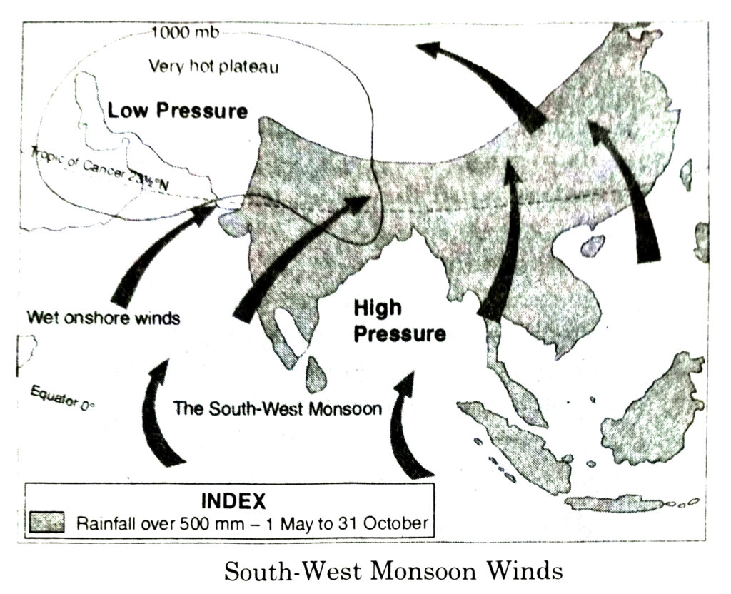
The Summer Monsoons : During the months of May and June rays of the sun are vertical on the Tropic of Cancer. So it is very hot in the northern plains of India. The air is heated, gets lighter and starts moving upward. All this results in the low pressure area in north-western India but the atmospheric pressure is comparatively high over the Indian Ocean. The winds always move from an area of high pressure towards an area of low pressure. Therefore, the winds begin to blow from the Indian Ocean towards the northern plains of India. These winds enter India from two different directions.
(1) Bay of Bengal branch.
(2) The Arabian Sea Branch.
1. Bay of Bengal branch of the Monsoons : The Bay of Bengal Monsoons enter India from two different directions.
One of its branches passes through Bangladesh and reaches Meghalaya where these strike against the Khasi, Garo and Jaintia hills, move upward and cause heavy rainfall. Mawsynram here receives the heaviest rainfall in the world.
2. The Arabian Sea Monsoons : The Arabian Sea Monsoons enter India from the three directions :
Its main branch strikes against the Western Ghats. As they are moisture laden they cause heavy rain on the western coast and the western slopes of the Western Ghats. After crossing the Western Ghats they become devoid of moisture,
Q. 2. Examine the significance of Monsoons in agriculture of India.
Or
“Indian budget is a gamble on Monsoons”. Discuss.
Ans.— Significance of Monsoons in agriculture
(i) India is essentially an agricultural country. Indian agriculture and economy is dependent on S.W. summer monsoons. Indian agriculture is the backbone or pivot of Indian economy. It has been rightly said, ‘Indian budget is a gamble on monsoons’.
(ii) Indian rainfall is seasonal. The summer crops or kharif crops depend on monsoons.
(iii) The failure of summer monsoons results in famines and food shortage. If monsoons fail, there is a lock-out in agriculture industry’.
(iv) Most of the foodgrains like rice, jowar, maize etc. grown as kharif crops depend on rainfall. Good rains have resulted in bumper crops.
(v) The amount of rainfall determines the cropping pattern. Rice, Sugarcane, Tea, Jute etc. are grown in areas with over 200 cms of rain. Dry areas have crops like millets, pulses, oil seeds, etc.
(vi) The uniform distribution of rain results in multiple cropping. (vii) Uncertain and variable rainfall requires the use of irrigation. The winter crops like wheat depend on irrigation.
(viii) Thus the agricultural rhythm of crops depend on rainfall. It has been often said, “The rain becomes the blood of life and agriculture is closely wedded to the monsoon.”
Q. 3. Describe the climatic conditions which prevail over India during different seasons.
Ans.— Seasons :
(A) Seasons of N.E. Monsoons.
(i) The Cold Season. December to February
(ii) The Hot Season. March to May
(B) Season of S.W. Monsoons
(iii) The Rainy Season. June to September
(iv) The season of Retreating Monsoon. October to November
1. The Cold Season : The cold season lasts from December to February.
(a) Temperature : The sun is overhead at Tropic of Capricorn. The Indian sub-continent has winter season. January is the coldest month. The southern parts have warm conditions (20°C) while low temperatures (10°C) are found in N.W. India.
(b) Pressure and Winds : High pressure is developed over N.W. part while a low pressure exists over Indian Ocean with the result winds blow from land to sea. The out-blowing winds are Westerly in Northern plains and North Easterly over the rest of the country.
(c) Rainfal : The N.E. Monsoons are off-shore winds and are dry. But these winds pick up some moisture while crossing Bay of Bengal and give rain to S.E. coast of India. Some cyclones from Mediterranean Sea also bring a small amount of rain (10 to 20 cms.) to Northern plains. Night Frost is common in the N.W. parts.
2. The Hot Season : The hot season lasts from March to May.
(a) Temperature : As the sun’s rays fall vertical over Tropic of Cancer, the temperature begins to rise’. The average temperature is above 30°C; the maximum temperature rises to 50°C in Barmer (Rajasthan). The daily range of temperature rises in inland areas.
(b) Pressure and Winds : Intense heat results in the developement of low pressure over N.W. India and Pakistan. A high pressure exists over Indian Ocean. S.W. Monsoons begin to blow from sea to land. ‘Norwesters’ and ‘Loo’ blow over Northern plains.
(c) Rainfall : Some areas receive convectional rainfall. The west coast also starts receiving rainfall. Most of the country is dry in the pre-Monsoon period.
3. The Rainy Season : The rainy season lasts from June to September.
(a) Temperature : The sun shines vertical over Tropic of Cancer. The temperatures are more than 30°C. With the onset of monsoon there is a drop in temperature (5° to 10°C) with the result, July is not the hottest month.
(b) Pressure and Winds : S.W. Monsoons blow from sea to land with a ‘burst’ on the West coast. It blows in two currents.
(i) The Arabian Sea Current. (ii) The Bay of Bengal Current.
(c) Rainfall : S.W. Monsoons are rain giver as most of the sub-continent gets rainfall in this season. The Arabian sea branch gives heavy rainfall on the West Coast, but Deccan plateau lies in rain shadow of Western Ghats. The Bay of Bengal branch gives heavy rainfall in Eastern Himalayas. The rainfall goes on decreasing up the Ganges valley with the decrease in moisture. Rajasthan is practically a desert.
4. The Season of Retreating Monsoon : S.W. Monsoons begin to withdraw from the sub-continent during the first week of October. The sun begins to move towards equator. There is a decrease in temperature. Hot and sticky weather is found. Some tropical cyclones are developed which give heavy rainfall in coastal areas. Cool weather begins in N.W. India, but the Southern parts have an equable climate.
Q. 4. Divide J&K into climate divisions. Describe the climate of each.
Ans.— CLIMATE OF J&K : The Climate J&K is mainly controlled by the factors like latitude, altitude, and distance from the sea, prevailing winds and relief. Keeping in view that the influence of above mentioned factors, the climate of J&K can be divided into the following climatic zones.
1. Sub Tropical Jammu,
2. Temperate Kashmir,
3. Arctic-Ladakh.
1. Jammu Division : Barring the highlands areas of Bhaderwah, Kishtwar, Gool Gulab Garh, Poonch Parts of Rajouri and Banihal, the rest of Jammu division experience a sub tropical type of climate. Jammu regions experience the following four seasons :
(i) The cold weather season: Mid Nov. to Mid March.
(ii) The hot weather season: Mid March to Mid June.
(iii) The South-West Monsoon season: Mid June to Mid September.
(iv) The retreating Monsoon season: Mid September to Mid November.
The mean monthly temperature in Jammu city reaches well above 20°C. June the hottest month recording a mean monthly temperature of about 31.6°C. The dry and hot wind often blows in the afternoon during summer season and the wind locally known Loo. January is the coldest month in the plains of Jammu in which average monthly temperatures reach around 13°C. The occurrence of frost fog and mist is quite frequent in the morning hours of winter season.
The month of July and August are the wettest months recording an average monthly rainfall of about 275 and 250mm respectively.
2. Climate of Kashmir Division : The valley of Kashmir along with some hilly areas of Jammu experiences temperate climate. The distinctive features of climate of Kashmir are :
(i) Mild summers
(ii) Vigorous and severe winters with snow and rain
(iii) A muggy and oppressive weather in July and August and
(iv) The most pleasant spring.
July is the hottest month in which maximum temperature may shoot upto 35°C at Srinagar. Janaury is the coldest month which is locally known as period of Chille-Kalan (40 days of intense cold). Rainfall occurs from mid July to mid September and heavy rainfall occurs during winter season.
3. Climate of Ladakh Territory.
Ladakh experiences a very cold and a very dry climate. A cold desert condition prevails in this region. The climate is often characterized by great experiences of heat and cold, with excessive dryness.
Ladakh receives a little amount of precipitation throughout the year. Precipitation is mainly in the form of snowfall, January is the coldest month in Ladakh, the lowest surface temperature -40°C was recorded at Dras in 1986.
MAP SKILL
Q. On the outline map of India, show the following (i) Areas receiving rainfall over 400 cms (ii) Areas receiving rainfall less than 20 cms (iii) areas of law rainfall in J & K.
Ans.—
QUESTIONS BASED ON MAPS AND DIAGRAMS
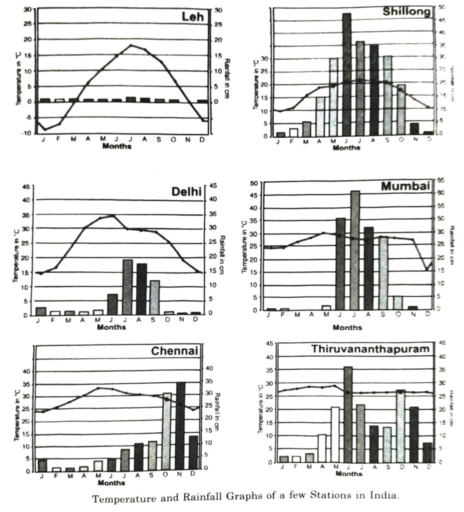
(i) Name the place having the highest annual range of temperature.
Ans.— Leh.
(ii) Name the place having the lowest annual range of temperature.
Ans.— Thiruvananthapuram.
(iii) Which place has the highest annual rainfall ?
Ans.— Shillong-225 cms.
(iv) Which place has the lowest annual rainfall ?
Ans.— Leh.
(v) Name the place having more rainfall in October-November.
Ans.— Chennai.
(vi) Name the place receiving almost all the rain from S.W. Monsoons.
Ans.— Mumbai.
(vii) Name the place having relatively extreme temperature and where rainfall is concentrated between June and September.
Ans.— Delhi.
Follow on Facebook page – Click Here
Google News join in – Click Here
Read More Asia News – Click Here
Read More Sports News – Click Here
Read More Crypto News – Click Here