WBBSE 10th Class Social Science Solutions Geography & Environment Chapter 1 Exogenetic Processes and Resultant Landforms
West Bengal Board 10th Class Social Science Solutions Geography & Environment Chapter 1 Exogenetic Processes and Resultant Landforms
WBBSE 10th Class Geography & Environment Solutions
TOPIC – 1
Exogenetic Process and the Works of Rivers
Long Answer Type Questions
1. Describe the various landforms formed due to erosional works of rivers.
Ans. The river performs three activities in its course of flow-erosion, transportation and deposition. The landforms formed due to erosional works of a river are-
- Canyons: The canyons are formed in the mountainous regions of arid climatic regions. The rivers which flow through these valleys are generally snowfed. They have high erosive powers due to great velocity. Downcutting of the valleys is prolonged while sidecutting is negligible, as there is no rainfall in this region and no tributaries meet the main river. E.g.- Grand Canyon of river Colorado.
- Gorges: In humid mountainous regions, the rivers flow with great velocity and have great erosive power. Downcutting of the rivers make the valleys very deep. At the same time, sidecutting of the valleys occur due to weathering, mass wasting and other activities. Thus, the valleys become wider, and look like the letter ‘V’. Example-Valley of river Kali in Nepal.
- Waterfalls: In the course of the river, if hard and soft rock beds lie alternately, the soft rocks get eroded very fast and the hard rocks stand out. This leads the water of the river to fall from a considerable height over a steep slope. Thus, a waterfall is formed. Example-The Angel waterfalls in the course of river Churun in Venezuela is the highest waterfalls of the world.
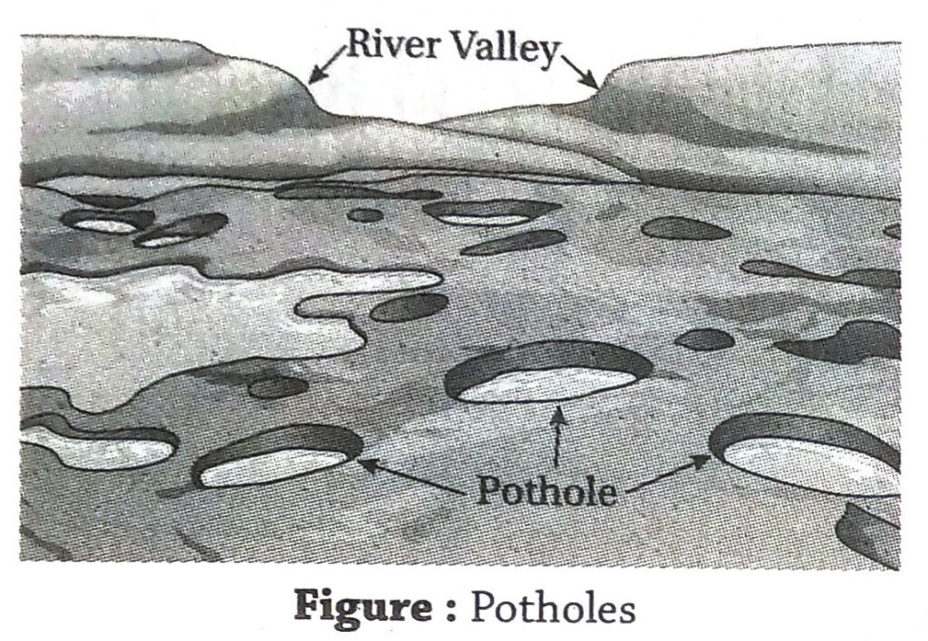
- Potholes: As the river flows, the rocks and boulders carried along with the water rub against the floor of the river bed and cause formation of small depressions due to abrasion. These are known as potholes. Example-Numerous potholes are present on the bed of river Tista.
- Plunge pools: As the water falls from a height with great velocity, the rock beds at the base of the waterfalls get eroded, and huge depressions are formed there. These are formed due to abrasion and the plunging of the water and hence they are called plunge pools. Plunge pools are potholes of bigger dimension.
- Interlocking spurs: In mountainous regions, the hard rocks or mountain ridges may lie in such a way that the river has to take frequent turns to avoid these obstructions while flowing. The river erodes the foothills of these mountains to curve out its own path of flow. A distant view at the landscape looks as if the mountains are inter- woven or are inter-locked. Such mountains are known as interlocking spurs.
- Truncated spur: A truncated spur is a blunt-ended, sloping ridge which descends towards a valley. Its abrupt termination is normally due to erosion by glaciers and rivers. Example-Truncated spurs are seen in the valleys of the rivers Tista, Torsa, Mahananda, etc.
2. Describe the various landforms formed due to the depositional works of rivers.
Ans. The various landforms formed due to depositional works of rivers are-
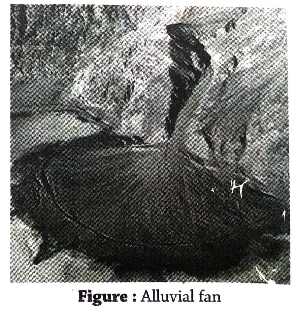
- Alluvial cone and alluvial fan: As the rivers emerge from the mountains, they erode heavily and flow with great speed. However, when they leave their mountainous course and enter the plains, they suddenly lose their speed. Thus, the carrying capacity of the river is reduced considerably. Hence, it deposits huge amount of rocks, pebbles, sand, silt, clay, etc. at the foothills of the mountains. These depositions look like a cone, and are called alluvial cones. If the cones spread wider, they are called alluvial fans. Example-Such alluvial cones and fans are present at the foothills of the Himalayas in the course of different tributaries of river Ganga.
- Sand bars and islands: In the middle course, the river is unable to flow with great velocity. Hence, it cannot carry the huge amount of load brought down from the mountains, and starts depositing them on the river bed. These depositions accumulate day after day and form sand bars or river islands. The rivers thus bifurcate at regions when it encouters such a sand bar along the flow. Such bifurcated channels are known as braided channels. Example-The Majuli island in the Brahmaputra river is the largest river island in India.
- Flood plains: In the middle course, the valleys of the river are wide, but less deep. During the rainy season, when the water volume in the channel increases, the river floods the adjacent areas. The silt, clay and. mud present in the river water also flow out and spread over the area. When the flood recedes, a part of the flood water flows back into the river and some percolates down to recharge the underground watertable. However, the silt and clay remain spread over the region. These silt deposits accumulated over the years form flood plains.
- Natural levees: On the plains, the silt, clay and sand particles flowing out of the river channel during floods get accumulated and compacted on the banks of the river. These. naturally forming accumulations rise in height forming a narrow belt of ridges and these are known as natural levees. Natural levees act as natural embankments and help in checking floods
- Delta: In the lower course of the river, the slope of the land becomes so negligible that the river cannot carry its load any further. It deposits the load gradually the near the mouth. These continued depositions eventually form small islands, encountering which the river channel bifurcates into several distributaries before meeting the sea. The islands formed resembles a triangle or the Greek alphabet ‘Δ’. Hence, the region is called a delta.
3. Discuss the favourable conditions for delta formation.
Ans. The conditions favourable for formation. of a delta are-
- The rate of deposition of silt and other materials by the river and its distributaries must be more than the rate of removal of the deposition by the sea waves.
- The rivers should have a long course and should have a number of tributaries, so that the eroded materials brought down altogether is sufficient for the development of a delta.
- The river should not be turbulent and speedy near the mouth, so that silt can easily deposit there.
- The continental shelf where the river meets the sea should be wide and gentle in slope, so that the sediments brought down can easily deposit there. A steep slope of the continental shelf will wash down the sediments into the deep sea and hinder delta formation.
- Deltas are easily formed if the prevailing wind direction in the region is opposite to that of the direction of the river.
- Deltas are formed easily in regions where the sea is a little enclosed with land rather than in regions with open seas.
- Almost stable condition (not subjected to any rejuvenation or submergence) of the sea coast and oceanic bottom will allow the deposits to settle down.
- Finer sediments will get carried away in suspension deeper into the sea. Very coarse and large size sediments would settle at the river bed. So, medium sized sediments are the most suited for delta formation.
4. How has the change in climate influenced the islands of Lohachara, New Moore and Ghoramara?
Ans. Climatic changes have endangered the existence of the islands of the Sundarbans to a great extent. Global warming has caused the melting of ice caps and glaciers to such an extent that, the sea level has risen considerably. This has led to the submergence of numerous small islands. The large islands of Lohachara, New Moore and Ghoramara have also faced submergence and have been named as ‘vanishing islands’. Numerous villages and agricultural fields have submerged, and thousands of people have become ‘climatic refugees’.
- Lohachara island: The Lohachara island existed in the Sundarban region near the mouth of the river Hooghly. In 2006, the island was submerged completely. In 2009, it started re-appeared, but presently it lies submerged.
- New Moore island: The New Moore island lies 2 km from the mouth of the river Hariyabhanga. It is a part of the Ganga- Brahmaputra delta region. In 1970, the island was submerged as an aftermath of the super cyclone ‘Bhola’. In 1974, the size of the island was 2500 sq.m according to satellite images. However, at present it lies completely under water as a submerged bar or bank.
- Ghoramara island: The Ghoramara island lies 92 km south of Kolkata, north of the Sagar Islands at the mouth of river Hooghli and east of the mouth of river Haldi in the Bay of Bengal. This is an island of the Sundarban region. In 1951, the size of the island was 38.23sq. km, but by 2011, the size reduced to a mere 4.37sq.km. Experts predict that the island will totally disappear due to submergence in the near future.
Short Explanatory Answer Type Questions
1. Mention the extent of the different courses of river Ganga.
Ans. The extent of the three courses of river Ganga are-
| Course of river |
Extent |
| Upper course |
From Gomukh in Gangotri glacier in Uttarakhand to Haridwar in Uttarakhand. |
| Middle course |
From Haridwar in Uttarakhand to Rajmahal hills in Jharkhand. |
| Lower course |
From Rajmahal hills in Jharkhand to the mouth of the river in Bay of Bengal. |
2. Discuss the various types of erosion.
Ans. Erosion by rivers can be divided into two types-chemical erosion and mechanical erosion, which further involves various methods.
1. Chemical Erosion
- Solution: This process involves the dissolution of soluble materials. The soluble materials are removed from their parent rocks by the processes of disintegration and decomposition. The removed materials mixes with the running water.
2. Mechanical Erosion
- Force of water: In the river valleys, the loose rocks may fall off the walls of the valleys due to continuous hitting of water, and may get carried away to distant places with the flowing water.
- Attrition: The rock fragments already broken away from the valley walls or river bed strike against each other and break into smaller fragments in this process. These fragments are carried with the water in suspension and transported down the channel.
- Abrasion: This process involves the removal of loosened rock materials from the valley walls and floors with the help of the tools of erosion. The rock fragments carried by the river collide and scratch against the river valley and erode materials from there, thus deepening and widening the valley.
- Hydraulic action: The bubbles created in the river water in the course of flow may burst together and produce sound waves, which can gradually break down the rock fragments into smaller parts. Solution: This process involves the dissolution of soluble materials.The soluble materials are removed from their parent rocks by the processes of disintegration and
3. On which factors does the carrying capacity of a river depend?
Ans. The carrying capacity of a river depends upon the following factors-
| Factor controlling carrying capacity |
Description |
| Volume of water |
Carrying capacity increases if the volume of water present in the river increases. |
| Velocity of the river |
Carrying capacity is mostly dependent on velocity of the river and slope of the land. According to the Sixth Power Law, if the velocity of the river is doubled, its carrying capacity is increased by 26 = 64 times. |
| Size and volume of load |
Carrying capacity depends on the size and volume of load being carried. If the size of the materials is small and the volume is less the carrying capacity increases and vice versa. |
4. Under which conditions does the river deposit its load?
Ans. A river deposits its load under thefollowing situations-
- Volume of water: Depositions occur when the volume of water in the river reduces. Volume of water reduces in the following situations- 1 When the river enters a region of low rainfall. 2 During period of droughts. 3 In dry seasons 4 In limestone or sandstone regions where water percolates down.
- Reduced slope: The velocity of the river reduces if it flows over a land with gentle slope and thus the reduced velocity enhances the deposition process.
- Bed load: If the amount of sediment carried by the river increases, as in the case of the middle and lower course of the river, the flow of the river becomes sluggish and thus it deposits much of its bed load to reduce the amount of sediment being carried.
5. What do you mean by river capture?
Ans. Streams emerging from two different sides of a water divide erode headwards. But, the rate of erosion depends on several factors(chanel gradient, stream velocity, etc.) and thus one stream becomes stronger than the other.The stronger stream erodes faster and greater. With the passage of time, the water divide is eroded off by the stronger stream and the two different flows become one, flowing in one particular direction. In other words, the discharge of the weaker stream unites with the discharge of the stronger stream, the former becoming the latter’s tributary. The river capturing the course of the other stream is known as the captor stream, while the part of the stream that has been divested of its course is known as the captured stream.
6. Mention the effects of the global climatic change on the active part of the Ganga-Padma-Meghna delta?
Ans. The effects of the global climatic change on the active part of the Ganga-Padma-Meghna delta are-
- Rise in temperature: During the period from 1980 to 2017, the temperature of water of the rivers of the Sundarban region has risen by 0.5°C per decade. This rise in temperature has caused great harm to the mangrove ecosystem.
- Cyclones and monsoon wind: The global climatic change has increased the frequency of the cyclones occuring in and hitting the Sundarbans. Clearing the mangrove forests to make way for human settlement has magnified the impact of the cyclones in this region.
- Rise in sea level: The global rise in temperature is causing the ice caps to melt at the poles. This in turn, is leading to the rise in sea level, posing a great threat to many islands and island nations of the world. Several islands of the Sunderbans are facing a similar danger. Example-Lohachara, South Talpatti.
- Increase in salinity: The rise in sea level is causing the water and soil of the Sundarbans to become saline. This is affecting agriculture, drinking water of the region, etc.
7. How are waterfalls formed in the course of a river?
Ans. When water of a river plunges from a higher elevation to a lower elevation, it is known as a waterfall.
In the course of a river, if hard and soft rock beds lie alternately horizontally one above the other, or diagonally, the harder rocks are less eroded and softer rocks are highly eroded by the river. This gradually gives rise to a steep slope over which the river plunges downwards. A waterfall may also be formed at a knick point along the course of the river where there is a sudden change of elevation in the longitudinal course.
Example-The famous Niagara falls lying along the course of Niagara river in the USA.
8. Explain why the river’s main work in the lower course is deposition.
Ans. In the lower course of the river, the slope of the land, over which the river flows is negligible. As a result, the flow becomes sluggish. Also, the amount of bed load carried in this course is huge.The river loses all its erosional and transportational capacities. Thus, the huge amounts of load brought down from the upper and middle course, get deposited along the lower course of the river. The depositional features seen here are flood plains, natural levees, deltas, etc.
9. Why do the rivers mainly cause erosion in their mountainous course?
Ans. The rivers mainly cause erosion in their mountainous course because-
- The mountainous regions have rugged terrain and steep slope, which increases the velocity of the flowing water.
- The valley walls and floors get highly eroded by the methods of hydraulic action, abrasion and attrition.
- The amount of sediment transported by the river in this course is much less and thus the erosive power of the rivers is more.
10. How is a delta formed in the lower course of a river?
Or, Explain why delta is formed at the mouth of a river.
Ans. In the lower course of the river, the slope of the land becomes negligible. Thus, the river loses its velocity and carrying capacity. The huge amount of sand, silt, clay, etc., brought down from the mountains is deposited in this region. The saline water at the mouth of the river where it meets the sea helps these deposited materials to get compacted. Thus, new islands are formed in the lower course of the river over a vast region from these deposited sediments. These islands are known as deltas. It must be noted that, the rate of deposition of sediments must exceed its removal rate by the sea waves as one of the factors affecting delta formation.E.g.- The largest delta of the world has formed at the mouth of the rivers Ganga-Brahmaputra.
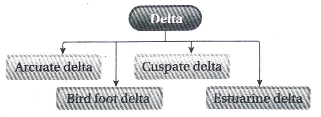
11. Classify deltas.
Ans. The deltas can be classified into four types according to their shapes-
- The deltas that look like an arc of a circle or a bow at the region or side that meets the sea, are known as arcuate deltas. E.g.-The deltas formed by the river Ganga, Nile, Po, Rhine, Hwang Ho, etc. are arcuate deltas.
- The deltas that resemble the foot of a bird pointing towards the sea, i.e., finer materials are deposited towards the sea are known as bird foot deltas. E.g.-The delta formed by the river Mississippi-Missourie.
- The deltas that are vaguely V shaped with curved sides are known as cuspate deltas. E.g.-The delta formed by the river Ebro.
- The deltas formed due to filling of the estuaries of the rivers are known as estuarine deltas. E.g.-The delta formed by the river Rhine.
12. How are oxbow lakes formed?
Ans. Oxbow lakes are formed mostly at the end of the middle course and beginning of the lower course of a river.
The curvatures of the meander loops of the river are enhanced due to continued lateral erosion by the rivers in their middle course. Thus, the two ends of the individual meander loops gradually come closer and their mouth is clogged by the sediments deposited by the river. The meander loop is eventually abandoned as the river.straightens its course. Thus, the water in the abandoned loop forms an oxbow lake.
Numerous oxbow lakes are seen along the course of river Ganga and its tributaries.
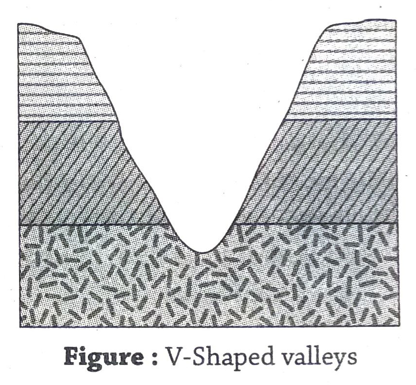
13. Why are ‘V’ shaped valleys formed in the upper course of a river?
Ans. The section of the river flowing through the mountainous region is known the upper course of a river. The shape of the river valley formed in this region due to downcutting is like a ‘V’. The causes of formation of the ‘V’ shaped valleys are-
- Slope of land: The slope of land is steep in mountainous regions. This causes the river to flow with great velocity. The high velocity of the river and the rock fragments carried with it collide with the river bed and cause more downcutting than sidecutting of the valleys. This makes the river valley narrow but deep.
- Heavy rainfall and weathering: In mountainous regions that receive heavy rainfall, the rate of weathering by mechanical and chemical processes is high. The dissolving of certain minerals (like limestone) and mass wasting removes huge amounts of rock debris from the region. This makes the river valleys deep ‘V’ shaped and gradually the valleys start becoming wide due to lateral erosion also.
- Others: Sometimes, landslides in river valleys that are very steep, cause them to widen and become ‘V’ shaped. Meeting of tributaries with the main river also makes the valleys ‘V’ shaped.
14. How are flood plains formed?
Ans. Flood plains are formed in the middle course of the river due to deposition of silt.
In the middle course of the river, when the volume of water suddenly increases due to heavy rainfall or due to snow-melt water draining into the river in the upper course, the excess water flows out of the river channel towards the adjacent plains on both sides of the river banks. Huge amount of sand, silt and clay flow out with this water and spread all over the area during times of flood. When the flood water recedes, some of the water flows back into the river, while some percolates underground.The silt and clay spread over the area form a thin layer of soil over the area. When this process continues year after year, the region develops into a new landform called a flood plain. Large flood plains are seen on both the banks of river Ganga and river Brahmaputra.
15. How do waterfalls move backward?
Ans. The plunging of water of a river from a height downwards, forms a waterfall. Such difference in height within the river course occurs due to presence of hard rock beds alternated with soft rock beds. As the water plunges from a height, it creates a plunge pool at the foot of the waterfall. This plunge pool increases in dimension over the time and the rocks of the wall seem to hang over a hollow. After a period of time this hanging wall collapses, thus the waterfall seems to move backwards, towards its source.
Example-The backward movement of the Chitrakoot waterfalls on river Indravati can be clearly understood.
16. How are the Sundarbans being affected by the climatic changes?
Ans. The climatic changes all over the world are also affecting the Sundarbans in the following ways-
- Due to the increased rate of global warming, the temperature of the earth will increase by 2-4°C by 2050. The amount of ice that will be melted due to this rise in temperature will increase the level of sea water. If the sea level rises by 1m, most of the islands in the Sundarbans would submerge. A few already have.
- The rise in sea level, is also turning the rivers nol of this region saline. This in turn, is affecting the plants and animals of the region.
- Saline soil is affecting the agriculture of the region and causing shortage of food.
- Increase in temperature is causing frequent cyclonic storms in this region.
17. What is the role of a river as a part of the water cycle?
Ans. The rivers help in the circulation of rainwater from one place to another. The rivers helps to prevent the rainwater from remaining arrested in a particular region.
The water present on the earth surface and in the atmosphere circulates through the hydrological cycle. The sun evaporates huge amount of water from the rivers, lakes, oceans and other waterbodies. The water vapour thus created, concentrates and forms clouds. These clouds cause snowfall and rainfall. The water coming. from the rain or melting of snow accumulates and flows down the slope of the mountains as rivers. The water in the rivers once again evaporate and forms vapour. A part of it also percolates down and recharges the underground watertable. Rest of the water flows into the ocean. This is how the river plays its important role in the water or the hydrological cycle.
18. Why are oxbow lakes formed in deltaic regions?
Ans. The oxbow lakes are formed in deltaic regions due to the following reasons-
- Meandering rivers: The slope of the land becomes negligible in the deltaic region. Thus, the river cannot flow with great velocity, and takes a turn wherever it is obstructed.
- Erosion at the curves of meanders: As the river starts meandering, erosion occurs at the concave side and deposition occurs at the convex side.
- Increase in the curve of the meanders: As the processes of erosion and deposition occur simultaneously in a meander, the curvature increases, and the two ends of the curve come very close to each other. As the ends of a curve of a meander come very close to each other, the curved part is cut off due to deposition from the main flow and the river continues to flow in a straight path. The enclosed body of stagnant water thus left behind becomes an oxbow lake.
19. What are constructive deltas and destructive deltas?
Ans. Constructive deltas: The rivers bring down huge amounts of sand, silt and clay from the upper course and deposit over vast areas to form a delta at its mouth. The size of the delta goes on increasing as more and more deposits are brought in. This is called a constructive delta. Constructive deltas can be of two types-1. Tongue-shaped (e.g.-delta of river Nile). 2. Bird foot shaped (e.g.-delta of river Mississippi).
Destructive deltas: The deltas which go on changing their shapes and sizes due to the action of waves and tides, are called destructive deltas. E.g.-Delta formed by river Rhone is highly a wave dominated delta.
20. Why do floods occur frequently in the lower course of the river?
Ans. The lower course of the river is frequently flooded due to the following reasons-
- The river contains huge volume of water in this course. However, the slope of the land is so negligible that the water cannot flow with great velocity towards the sea.
- The maximum of the load brought down by the river is deposited in this region. Thus, the depth of the river channel gradually decreases. During the rainy season, as the volume of water in the channel in the upper course increases the lower course cannot hold the huge volume of water, hence the banks on either sides get flooded.
21. Why is the degradation process called a destructive process?
Ans. Degradation is the process by which the higher landforms are lowered by erosion, mass wasting and denudation so as to attain an equilibrium position or a graded profile. Since, the original landforms are eroded and lowered by the process of degradation, it is considered as a destructive process.
22. Why is vertical erosion or downcutting of river valleys in the upper course more prominent compared to lateral erosion or sidecutting?
Ans. The level of downcutting or vertical erosion of river valleys in the upper course is more prominent compared to sidecutting or lateral erosion because the river flows over a steep slope in the upper course, hence has high velocity.Also, the river carries a huge amount of rocks and pebbles in this stage, which act as tools of erosion.
Thus, the valleys are deepened due to abrasion by the tools of erosion and the force of the flowing water.
23. Why are islands and sand bars created in the middle and lower course of a river?
Ans. Islands and sand bars are formed in the middle and lower course of the river because of the following reasons-
- The speed of the river reduces in the middle course as it leaves the mountainous region and enters the plains. Owing to gentle slope of the land and increased bed load the carrying capacity of the river reduces considerably.
- Depositions start occurring on the river bed. As more and more depositions occur, the sand bars grow bigger in size and rise out of the water as islands.
24. Why have numerous islands and sand bars formed on the river Brahmaputra?
Ans. Numerous islands and sand bars have formed on the river Brahmaputra because-
- The course of the river Brahmaputra flowing through Assam is the middle course. Hence, the river flows with less velocity.
- The load brought down by the river gets deposited on the river bed and creates sand bars.
- Numerous tributaries join the river Brahmaputra and contribute huge amount of water as well as eroded materials. Thus, more sand bars are formed and each of them grows larger in size. Example-Majuli island has been formed in a similar way.
25. How is landform levelled by the process of gradation?
Ans. Gradation is the process of levelling of rugged and uneven land into a smooth and even landform. It is the combined outcome of the process of degradation and aggradation. A graded profile is one in which no further erosion or deposition takes place.
Gradation is the combination of both degradation and aggradation. The high hills and rugged topography are lowered and levelled due to erosion by wind, water, snow,etc. This is known as degradation. By the process of aggradation, the low lying regions, the depressions and gaps are filled up by the deposition of eroded materials brought down by rivers, glaciers or wind. Degradation and aggradation processes go on continuing unless the graded profile is attained.
Short Answer Type Questions
1. What do you mean by a river?
Ans. A natural flowing body of water from the uplands to the lowlands under the gravitational force following the slope is known as a river. It originates in the mountains, hills or plateaus and drains into seas, lakes or other waterbodies. A river maybe both snow-fed or rain-fed. E.g. rivers Ganga, Brahmaputra, Yamuna, etc.
2. What do you mean by tributaries and distributaries? Give examples.
Ans. Tributaries: The smaller streams of water from the nearby areas that join the main river are called tributaries. Tributaries contribute their water as well as eroded materials to the main flow. E.g. Yamuna is the most important tributary of river Ganga. Distributaries: The small streams branching out from the main river near its mouth in order to distribute its excessive bedload are called distributaries. The load deposited by the distributaries over a vast region form the delta, e.g. Bhagirathi-Hooghli is an important distributary of the river Ganga.
3. What is an ideal river? Give example.
Ans. The river which exhibits all the three courses, i.e., the upper, middle, and lower course prominently is called an ideal river. The river generally erodes in the upper or mountain course, transports in the middle course and deposits in the lower or delta course. The middle and the lower courses are spread over vast areas. An ideal river doesn’t change its course frequently. Example-River Ganga is an ideal river.
4. How can the course of a river be divided based on the work done?
Ans. A river performs three activities right from its source to its mouth. The river course can be divided into three parts based on its work done. They are as follows-
- Upper course, marked mostly by the erosional work of the river.
- Middle course, marked mostly by the transportational work of the river.
- Lower course, marked mostly by the depositional work of the river.
5. What is the sixth power law?
Ans. The velocity of the stream(river) is one of the major factors on which its carrying or transportation capacity depends. A law to establish their relationship is known as the sixth power law, propounded by G.K. Gilbert. It states that, the transportation power of the streams is proportional to the sixth power of its velocity. In other words, if the stream velocity is doubled, the transportational power of the stream increases 64times. This law can be expressed in the following manner- Transportation power a (stream velocity)6
6. What is a water divide?
Ans. The elevated land acting as a boundary between two river systems is known as a water divide. The water flowing from each side of the water divide flows into each seperate body of water. The height of the water divide ranges from a slight elevation on a plain land to a crest on a mountain range.
7. What is a catchment area?
Ans. A catchment area or a drainage basin is an entire area that collects the rainwater and contributes it to a channel. The shape of a drainage basin determines how rapidly will the run-off reach the main river and the outlet.In case of circular basins the run-off reaches quickly as compared to the elongated basins.
8. What is a river valley?
Ans. The valley carved out by the river due to excessive downcutting and sidecutting along its course is known as a river valley. The shape and dimension of such valleys vary in each course of the river. V-shaped valleys are formed by the river in its youth stage or upper course while, flat valleys are formed when the river reaches its mature stage in its middle course.
9. What are gorges?
Ans. The narrow steep-sided valleys formed in the mountainous regions due to heavy downcutting by the rivers are known as gorges. These valleys are V-shaped valleys. Here, vertical erosion by the rivers is more prevalent than lateral erosion. Example-Kali Gandaki gorge is a famous gorge in the Himalayas.
10. What are potholes?
Ans. In the upper course of the river, holes and depressions formed in the beds of the river valleys by the rock fragments and boulders brought down by the rivers are called potholes. Potholes are formed when the rocks get caught in the whirling water, moving in a circular manner and drill the rocky beds of the valleys to form small holes. These holes gradually becomes bigger by the repetition of the same mechanism.
11. What are meanders?
Ans. The bends in the longitudinal course of the river are called meanders. Meanders have been named after the River Meander in Turkey because it flows through several bends. Once the river emerges onto the plains it loses speed due to the gentle slope of the land. The slightest of obstruction in the course forces the river to flow through various bends. Each of these bends has two types of slope. The side where the river strikes has a concave slope and is subjected to severe erosion. The other side is characterised by a convex slope where all the eroded materials are deposited.Thus, meanders are a result of both erosion and deposition.
12. What are interlocking spurs?
Ans. In a mountainous region, the mountain ridges obstruct the flow of the river in such a way that the river has to erode the foothills and take frequent turns in order to avoid the ridges. From a distance, it appears that the ridges have been interwoven and the river has disappeared into the ridges. Such series of mountain ridges are known as interlocking spurs.
13. What is a cascade?
Ans. A series of step-like waterfalls that originate when the river flows over an area with alternating bands of hard and soft rock beds is known as a cascade.E.g. Jonha waterfalls in Ranchi, Jharkhand.
14. What is a canyon?
Ans. Canyons are formed when the river flows through a dry, rainless region where the rate of lateral erosion is far less than the rate of vertical erosion. Prolonged downcutting by the rivers through the soft rocks form long and narrow steep sided valleys. These valleys formed resemble the shape of the letter ‘I’ and are known as canyons. Example-Grand Canyon.
15. What do you mean by the base level of erosion?
Ans. The limit of maximum downward erosion by a river is known as the base level of erosion. The base level of erosion can be further divided into grand base level, temporary base level and local base level. The sea level becomes the grand base level beyond which no dryland can further erode. There may also be a temporary base level of a river course depending on the presence of lakes or beds of hard and soft rocks along the course.The local base level of erosion on the other hand depends on the confluence of the tributary stream with the main stream.
16. What are endogenetic forces?
Ans. The forces that act from within the earth are called endogenetic forces. These forces cause two types of movement in the earth, namely, vertical movement and horizontal movement. These movements give birth to various relief features such as plateaus, plains, lakes, folds, faults, etc. Volcanic eruptions and earthquakes are also a result of endogenetic forces.
17. What are exogenetic forces?
Ans. The forces which act on the surface of the earth externally and cause changes in landforms, are called exogenetic forces. These forces are also known as denudational forces. Exogenetic forces are constantly engaged in destruction of relief features which have been formed due to the endogenetic forces. Rivers, glaciers, winds, underground water, sea waves, are some exogenetic forces that work to change the landforms on the earth’s surface.
18. What do you mean by gradation?
Ans. The process of acquiring a smooth and graded profile of landform that lies in equilibrium is called gradation. Gradation includes three processes. The higher landforms are eroded and smoothened in the first phase. In the second phase, the eroded materials are transported by the agents of erosion. In the third phase, the eroded materials are deposited in lowlands or depressions to obtain a graded profile. Thus, gradation helps to eliminate the vertical irregularities of relief on the surface of the earth.
19. What is degradation?
Ans. The process of lowering of height of a landform by different exogenetic forces is known as degradation. It is a destructive force. Weathering, mass wasting and erosion are the processes that cause degradation.
20. What is aggradation?
Ans. The process of increasing the height of a landform by deposition of materials eroded from elsewhere, is known as aggradation. It is a constructive process. Aggradation leads to the formation of alluvial fans and cones, flood plains, etc.
21. Mention a few instances in which humans and animals act as agents of erosion.
Ans. At times, human beings and animals also act as active agents of erosion. Mining, constructional and agricultural activities cause widespread localised erosion. Burrowing animals such as rabbits, beavers also act as agents of erosion.
22. What are peneplains?
Ans. The featureless plains dotted with small undulations formed at the end of the cycle of erosion by rivers are known as peneplains. The river erodes the high landforms over a considerable period of time and lower them. The soft rocks are eroded away faster and the hard rocks stand out on the surface as they are eroded less. These hard rocks standing out as highlands on a plain surface are known as monadnocks. E.g.- The Chotanagpur region is a peneplain, and the Pareshnath and Panchet hills lie as monadnocks.
23. Which is the middle course of a river?
Ans. The river emerges onto the plains from its mountainous or upper course and henceforth this course of the river on the plains is known as its middle course. All along this course the speed of the river reduces comparatively but the volume of the water carried inceases. Transportation of the eroded materials from the upper course is the main activity of the river in this course. Deposition of the eroded materials is also partially seen along this course. Example-The course of the river Ganga between Haridwar and Rajmahal hills is its middle course.
24. Which is the lower course or delta course of a river?
Ans. The course of the river flowing through the plains when reaches near its mouth is known as its lower course. The speed of the river in this course is vastly reduced due to the gentle slope of the land. The flow also becomes sluggish due to the huge amount of sediment that is carried with the water as bed load. This leads to the deposition of the sediments near the mouth forming deltas. Example-The portion of the river Ganga, lying between Rajmahal hills to the mouth in the Bay of Bengal is known as the lower course of the river.
25. What is Plunge Pool?
Ans. In mountainous regions, waterfalls are created where the river drops from a considerable height with great velocity. Small depressions or hollows known as potholes are created at the base of the waterfalls due to pounding of rock fragments brought down by the water. These potholes gradually grow bigger in size to form Plunge Pools.
26. Why is the Lohachara island submerging?
Ans. The Lohachara island at the mouth of the river Hooghli is gradually submerging because-1. The sea level is rising. 2. Severe cyclonic storms are hitting the area frequently. 3. The mangrove forests are being cut down and thus the coasts are being exposed to erosion.
27. What do you know about the South Talpatti island?
Ans. The South Talpatti island is also known as New Moore island existed 2 km away from the mouth of the river Hariyabhanga in the Sunderbans. The cardinal location of the island was 21°37’00″N and 89°08’30″S. The island emerged as an aftermath of the Bhola cyclone in 1970. According to satellite images, the island was about 2500 sq.km in area. The island is currently submerged due to the rise in the sea level as reasoned by scientists.
28. What is the current condition of the Ghoramara island?
Ans. The Ghoramara island lies 92 km south of Kolkata, north of the Sagar islands at the mouth of river Hooghli and east of the mouth of river Haldi in the Bay of Bengal. This is an island of the Sundarban region. In 1951, the size of the island was 38.23sq. km, but by 2011, the size reduced to a mere 4.37sq.km. Experts predict that the island will totally dissapear due to submergence in the near future.
29. What do you mean by rejuvenation?
Ans. Rejuvenation means acceleration of the erosive work of the rivers due to various factors. This lengthens the period for the cycle of erosion of the rivers. A river may be rejuvenated due to earth movements that cause upliftment or depression of land, substantial fall in the sea level, river capture, etc. Landforms created due to rejuvenation of rivers include knick points, valley in valley topography, incised meanders, paired terraces, etc.
30. What is a knick point?
Ans. After the rejuvenation of a river, the point lying between the old slope and the new slope is known as the knick point. Waterfalls are formed at the knick points as the difference in the level of the old slope and the new slope creates a considerable difference in height for the water to jump.The knick point gets eroded gradually with time and matches the graded profile of the region.
31. What do you mean by abrasion?
Ans. Abrasion or corrasion is a type of erosion. The natural agents of erosion like rivers, glacier and wind bring down rock fragments, pebbles, sand and stones along with them that rub against the rock beds on the surface of the earth. This is known as the process of abrasion. Thus, the surface is polished and eroded fast by the removal of loosened materials.
32. What are rapids?
Ans. Waterfalls of smaller dimensions are known as rapids. They are usually found upstream from the main falls or are even found independently. Example-Rapids are seen in the mountainous course of many Himalayan rivers.
Multiple Choice Type Questions [MCQ type]
Write the correct answer from the given alternatives
1. Which among the following exogenic forces is responsible for the changes in landform in the humid regions receiving adequate rainfall?
A. Glacier
B. Wind
C. River
D. Solar Energy
Ans. C
2. The longest river in the world is-
A. Mississippi-Missouri
B. Nile
C. Yangtze Kiang
D. Ganga
Ans. B
3. ‘Knick point’ of a river is seen in case of-
A. Oxbow Lakes
B. Flood plains
C. Waterfalls
D. Alluvial Cones
Ans. C
4. Alluvial cones are formed in the rivers in the-
A. Upper course
B. Delta region
C. Transition between upper and middle course
D. Transition between middle and lower course
Ans. C
5. The river valleys created in the dry regions due to downcutting of soft rocks are called-
A. Gorges
B. Canyons
C. Hanging valleys
D. Crevasses
Ans. B
6. The steps formed on the sides of the river in case of rejuvenation of the landscape-
A. River terraces
B. Natural levees
C. Moraines
D. Interlocking spurs
Ans. A
7. The very deep and narrow ‘V’-shaped valleys are called-
A. Gorges
B. Canyons
C. Interlocking spurs
D. Plunge pools
Ans. A
8. Potholes are created by the erosional work of-
A. Rivers
B. Wind
C. Glaciers
D. Waves
Ans. A
9. Alluvial fans form near the-
A. Higher slopes of mountains
B. Foothills of mountains
C. Delta region
D. Middle course of the river
Ans. B
10. Small rivers that meet the main river are called-
A. Distributaries
B. Tributaries
C. Non-perennial rivers
D. Perennial rivers
Ans. B
11. The largest river basin of the world in terms of area is the-
A. Ganga basin
B. Congo basin
C. Amazon basin
D. Nile basin
Ans. C
12. The unit for measuring the volume of water flowing through a certain part of a river is said to be 1 cusec, when the volume of water flowing through is-
A. 1 cubic meter
B. 1 cubic foot
C. 1 cubic inch
D. 1 cubic centimeter
Ans. B
13. The largest riverine island of the world is-
A. Mariana Islands
B. Marajo
C. Sagar Islands
D. Majuli
Ans. B
14. The saltation process of a river leads to-
A. Erosion of materials
B. Transportation of materials
C. Deposition of materials
D. Sedimentation of materials
Ans. B
15. When the speed of the river increases by two times, its carrying capacity inceases by-
A. 7times
B. 2times
C. 3times
D. 64times
Ans. D
16. The waterfalls of smaller dimension are called-
A. Cataracts
B. Cascades
C. Rapids
D. Caprock falls
Ans. C
17. An example of an exogenetic process of landform formation is-
A. Vulcanicity
B. Rising of fold mountains
C. Formation of block mountains
D. Erosion by rivers
Ans. D
18. All exogenetic processes lead to-
A. Gradation
B. Accumulation
C. Degradation
D. Aggradation
Ans. A
19. The main cause of submergence of the islands of Sundarbans is-
A. Heavy rainfall
B. Cyclones
C. Rise in sea level
D. Floods
Ans. C
20. The delta at the mouth of River Nile on the basis of its shape is a /an-
A. Abandoned delta
B. Arcuate delta
C. Truncated delta
D. Bird foot delta
Ans. B
21. The sediment depositions on the convex side of meanders are called-
A. Pool
B. Pointbars
C. Plunge pool
D. Flood plains
Ans. B
22. Which among the following is not an island of the Sundarbans?
A. Ghoramara
B. Purbasha
C. Majuli
D. Lohachara
Ans. C
23. The process by which natural agents reshape the existing landscape over the earth’s surface is known as-
A. Exogenetic process
B. Endogenetic process
C. Orogenetic process
D. Epeirogenetic process
Ans. A
24. An invisible island of the world is-
A. Ghoramora
B. Sagar Islands
C. Sandeshkhali
D. Nayachar
Ans. A
25. The altitude of a lowland increases by-
A. Aggradation process
B. Degradation process
C. Abrasion process
D. Denudation process
Ans. A
Fill in the blanks with suitable words
1. A fault lying across the river in a mountainous region gives rise to a ………
Ans. Waterfall
2. ……… are created due to erosion by rivers in the mountainous or upper course.
Ans. Gorges/Canyons
3. In the upper course of a river, downcutting of valleys mainly occur due to ……..
Ans. Abrasion
4. Cliffs present in the course of a river form large waterfalls called ………
Ans. Cataracts
5. The longest river of the world is river ………
Ans. Nile
6. The largest river of the world in terms of volume of water is river ………
Ans. Amazon
7. The islands of New Moore and Ghoramara have submerged due to ………
Ans. Rise in the sea level
8. An example of an endogenetic process of landform formation is ………..
Ans. Plate movement
9. Erosion by rivers and glaciers is an ………. process of creating landforms.
Ans. Exogenetic
10. Two important works in exogenetic processes are erosion and ……..
Ans. Deposition
Answer in one or two words
1. How far does the upper course of river Ganga lie?
Ans. Gomukh to Haridwar.
2. On which course of the river depositional activities are the least?
Ans. Upper or mountainous course.
3. What is the curved flowing path of a river called?
Ans. Meander.
4. What is the depositional feature of a river looking like a fan called?
Ans. Alluvial fan.
5. Name the type of lake which is formed by being cut off from the river in its middle course.
Ans. Oxbow lake.
6. Name the place where the river meets the sea.
Ans. Estuary.
7. What is the sediment carried by the river called?
Ans. Bed load.
8. Name the process of erosion in which air bubbles trapped in small spaces implode to erode rocks.
Ans. Cavitation.
9. Which is the world’s longest estuary?
Ans. Gulf of Ob (at the mouth of River Ob).
10. What are the exogenetic forces also known as?
Ans. Destructive forces.
11. Which is the largest drainage basin of the world in terms of area?
Ans. Amazon drainage basin.
12. What is the cause behind the gradual submergence of the islands of Ghoramara, Lohachara, etc.?
Ans. Rise in sea level.
13. What is a river with all its courses well defined called?
Ans. Ideal river.
14. What are the valleys carved out by rivers called?
Ans. River valleys.
15. Name two islands of the Sundarbans that are on the verge of submergence.
Ans. Suparibhanga and Kapasgadi.
16. Who was the first to use the term ‘grade’ in geology?
Ans. Geologist Gilbert.
17. Who propounded the concept of gradation in geology?
Ans. Geologists Chamberlain and Salisbury.
18. Name the main source of energy for the exogenetic processes.
Ans. Sun.
19. What is the process of removal of weathered rocks to other places called?
Ans. Erosion.
TOPIC 2
Works of Glaciers
Long Answer Type Questions
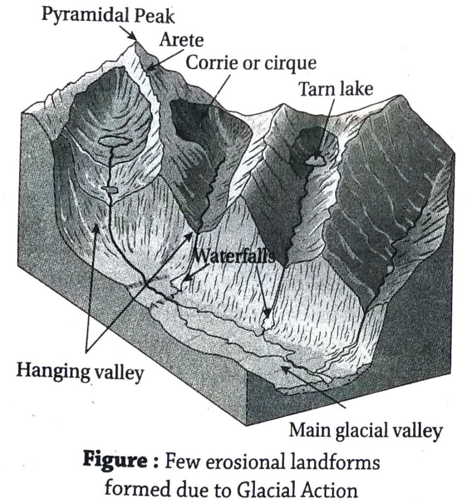
1. Describe a few landforms formed due to erosional works of glaciers.
Ans. The glaciers erodes the valley or region through which it flows and forms several landforms. A few of them are as follows-
- Cirque: The glacier erodes by the processes of plucking and abrasion. At the source of the glacier, the mountain wall is eroded heavily and the landform thus formed looks like a huge armchair. This is known as a cirque.Rock basins formed at the floor of the cirques gets filled up with water after deglaciation and are known as cirque lakes or tarn lakes. Cirques, are known by different names at different places. Cirques can be divided into three parts- 1 Steep wall at the back, 2 Semi-circular depression in the middle, 3 Threshold or hunch at the lower part. The cirques may get filled with snow-melt water and form lakes. Example-Such landforms are seen in the glacial regions of the Himalayas, Alps, etc.
- Arete: In the snow-covered mountainous region, two or more glaciers can originate from different slopes of a single mountain. Thus a number of cirques will be formed in the same mountain. Due to headward erosion, the cirques may get deeper, and the portion between two adjacent cirques lie like a steep, sharp narrow wall. This is called an arete. If the mountain has three or more aretes, if forms a pyramidal peak. The tip or peak of such a pyramidal peak is called a horn. E.g. – The Matterhorn peak.
- Hanging valleys: In a glaciated region, the main or trunk glacier carries a greater volume of ice than the tributary glaciers. Thus the main glacier has greater erosive power than the smaller tributary glaciers. Hence, the main glacier forms deeper valleys and the tributary glaciers form comparatively less deep valleys. These are not visible as long as the ice cover remains. When the glaciers melt or recede, the small valleys are found to be hanging over the huge deep valleys, due to different rates of erosion during their formation. Such valleys are called hanging valleys.
- U-shaped valley: In a mountain glacier, the glacier descends from the cirque and flows through the valley. The intensity of side erosion or lateral erosion is almost same as the intensity of vertical erosion of the glacial valley by the processes of abrasion and plucking. Thus, the valley developed looks like the letter ‘U’. These valleys are called U-shaped valleys.
- Fjord: In regions where the mountain glaciers meet the coast directly, the valleys may be eroded so deep that the base or bed of the valley may lie lower than the sea level. When the ice melts or recedes these depressions get filled up with sea water. Such regions look like valleys that have been submerged in ocean water, while the ridges stand out. These submerged valleys are known as fjords. Such a coast is known as a fjord coast. Examples of fjords are seen in Norway and Finland.
- Roches mountonnee: In the path of a glacier, if a hard rock stands like an obstruction, the glacier rides over it while crossing it. In this process the side over which it rides, gets smoothened and polished by the rocks and pebbles, embedded in the glacier. On the other side, over which the glacier descends, the rocks and pebbles are plucked out from the wall as the glacier moves. Thus one side of the rock mass is smooth while the other is rough and uneven. This rock feature forms a roches mountonnee.
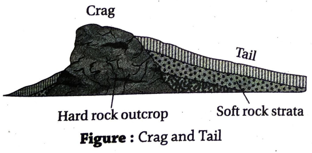
- Crag and tail: Along the path of the glacier if there lies a volcanic rock it projects above the ground as a resistant rock. These volcanic rocks offer resistance to the flow of ice and thus the side facing the direction of flow becomes steep due to erosion. This is known as crag.The other side being sheltered by the ice becomes elongated and has gentle slope.This elongated side is known as tail.
- Glacial stairways: When the glaciers descend from very high mountains into valleys, they develop steps or stairs along the walls of the valleys through the processes of abrasion and plucking. The steps may develop due to unequal distribution of load in the glacier or alternate alignment of hard and soft rock beds. These steps are known as glacial stairways. Further, small depressions formed in these steps get filled up with snowmelt water, later. These depressions are known as paternoster lakes.
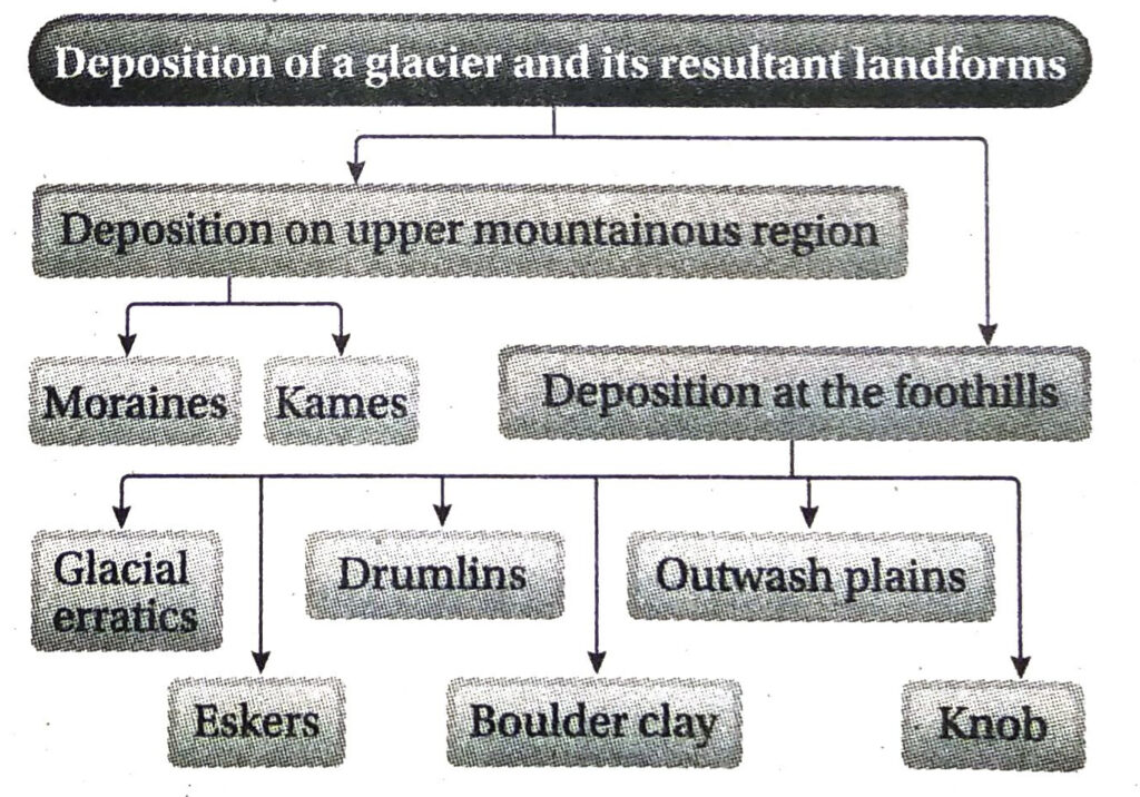
2. Describe a few landforms formed bythe depositional works of glaciers.
Ans. The depositional works of glaciers can be broadly classified into two parts-
1. Depositional landforms in higher altitudes:
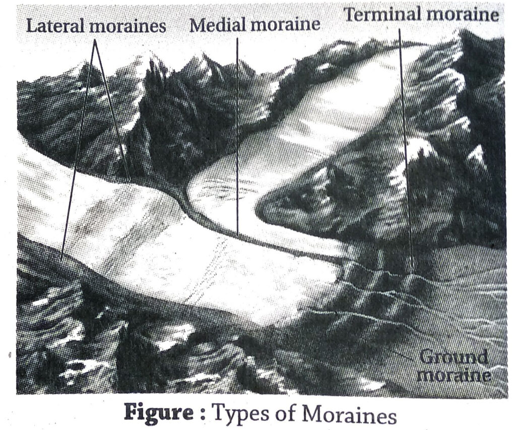
- Moraines: The debris of rocks and pebbles that the glaciers carry as they flow through the valleys, get deposited in parts along the sides, bed or at the end of the glaciers. These are known as moraines. They are named side moraines or lateral moraines, medial moraines and end or terminal moraines based on their locational aspect.
- Kames: At the end of the glacier, as the ice melts, the rocks, pebbles, sand and gravel brought down by the glacier gets accumulated and deposited in triangular shapes, resembling deltas of rivers. They are called kames. Narrow flat topped terrace like ridges are called kame terraces.
2. Depositional landforms in lower altitudes:
- Glacial erratics: The glaciers bring down rocks and boulders along with them in their course. When they melt, these rocks and boulders may get carried to distant places with the snow-melt water, and get deposited there. These rocks have no similarities with the local rocks of that region. Such rocks are called glacial erratics.
- Eskers: The rocks, sand, clay, pebbles, etc. brought down by glaciers may get deposited like low ridges at the foothills of the mountains. They may be curved and branched. These ridges are called eskers. E.g.- Punkaharju esker in Finland.
- Drumlins: When boulder clay is deposited in large heaps that look like inverted boats, they are known as drumlins. A number of drumlins lying in a region look like a ‘basket of eggs topography’.
1
- Boulder clay: The accumulation of sand, clay, rocks and boulders at the base of the valley after the glacier melts is known as boulder clay.
- Outwash plains: At the end moraine, where the glacier melts and gives rise to the river, the rocks, pebbles, clay and sand brought down by the glacier are carried as bed load by the river water and spread over extensive areas. The plains thus formed are called outwash plains. The big chunks of hard ice that come along with the rock debris, make depressions, on the ground. These are called kettles. When the hard ice melts, these depressions get filled up with water and form kettle lakes.
- Knobs: Rocks and pebbles brought down by glaciers and carried along with flowing water are deposited on the outwash plains like domes or low hillocks, they are called knobs.
Short Explanatory Answer Type Questions
1. What do you understand by a glacier?
Ans. The high altitude and high latitude regions receive snowfall instead of rainfall. This snow is very soft and forms a layer over the earth’s surface. As the volume of snow increases, the lower layers of snow start getting compacted into hard ice due to pressure from the upper layers. When the volume of the ice becomes huge and the weight becomes too heavy, it starts moving downwards along the slope of the land due to gravitational pull. Such a moving body of ice is known as a glacier. As the glacier moves downwards, the lower layers receive friction from the valley bed and walls and melt a little. This works as a lubricant to help the glacier move easily.
2. How does the glacier erode?
Ans. The glacier erodes generally by two methods-1. Plucking and 2. Abrasion.
- Plucking: The moving glacier exerts pressure on the walls and bed of the glacial valley and pulls out pieces of rocks from there. This process is known as plucking.
- Abrasion: The rocks and boulders present in the glaciers hit against each other and against the walls and beds of the glacial valleys. Thus, the valleys are eroded, widened and smoothened. This method of erosion is called abrasion.
3. Classify the glaciers.
Ans. The glaciers can be broadly classified into three types-
- Continental glaciers: The glaciers that lie like sheets of ice over vast regions of the continent are called continental glaciers. Such glaciers are present in Antarctica (almost 85% of the region), Greenland, Iceland. Characteristics: [i] These glaciers spread from the centre towards all directions. They look like the back of a tortoise. [ii] Ice present at the end or margin of the glacier is not very thin. [iii] Continental glaciers create ice shelves. [iv] These glaciers were formed in the Quaternary Period. [v] E.g.- Ross Ice Shelf in. Antarctica.
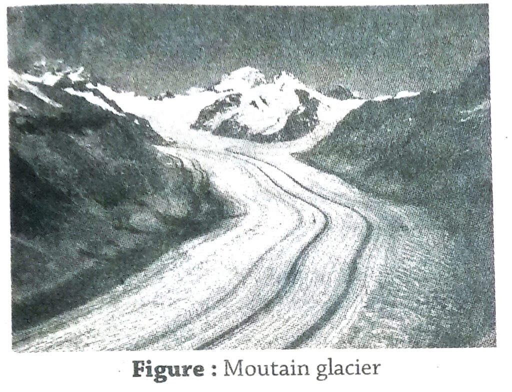
- Mountain or valley glaciers: The glaciers that come down from very high mountains through the valleys are called mountain glaciers or valley glaciers. Characteristics: [i] The length of these glaciers ranges from a few kilometres to 2000 kilometres [ii] Most of the rivers rise from the valley glaciers. [iii] These glaciers develop faults and cracks on the surface, known as crevasses. E.g.- The Zemu and the Kanchenjunga glacier in Sikkim.
- Piedmont glaciers: The glaciers formed at the foothills of mountains due to coalescence of several mountain or valley glaciers are called piedmont glaciers. Characteristics: [i] These glaciers are generally smaller in size. [ii] The round portion in front of these glaciers is known as ‘lobe’. [iii] These glaciers are only found in the colder regions and not in the tropical and temperate regions. [iv] E.g.- Malaspina glacier in Alaska.
4. Name the longest and fastest glaciers of the world and the largest glacier of India.
Ans. Longest glacier of the world: Lambert glacier in Antarctica. It is about 400 km long.
Fastest glacier of the world: Jakobshavn glacier in Greenland. It moves for about 40m per day.
Largest glacier of India: Siachen glacier in Karakoram range. It is 76 km long. It is located in the eastern Karakoram range of the Himalayas.
5. Why are waterfalls formed from hanging valleys?
Ans. In hilly regions through which glaciers flow, the main glacier being longer, wider and more extensive erodes much more than the small tributary glaciers. Thus, the valley of main glacier is deeper than the valleys of the small tributary glaciers. When the ice melts, the small glacial valleys seem to hang over the main valley due to difference in height. The rivers formed due to melting of the glaciers flow through these glacial valleys. The water pouring in from the tributary glacial valleys into the main valley jumps downwards due to difference in elevation, thus creating waterfalls. Example-Vasudhara waterfalls near Badrinath.
The rivers flowing through this region gradually erode the glacial valleys and try to reduce the slope of land.
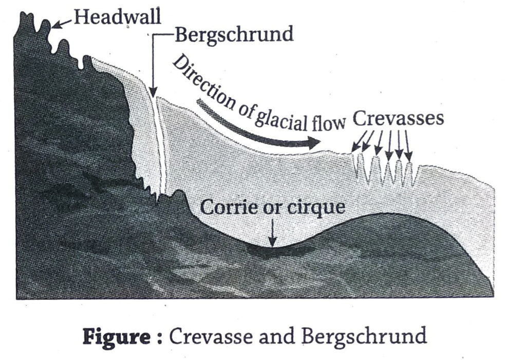
6. How are crevasses and bergschrunds formed?
Ans. In high mountainous regions, where heavy snowfall occurs, the ice gets compacted gradually and gives rise to glaciers. Several erosional and depositional features are formed in glaciers.
Bergschrund: At the source of the glacier, where the corrie is formed, the ice seems to tear
apart from the headwall of the corrie as the glacier begins to flow. This creates a long, narrow and deep fault or trench near the wall of the corrie in the snow. This is know as the bergschrund.
Crevasses: As the glacier advances, it crosses many types of slopes on its way. This may create several cracks on the surface of the glacier which are comparatively shallow. These are known as crevasses.
Both bergschrunds and crevasses remain covered with a thin film of fresh snow. Thus, they can be of great danger to mountaineers.
7. What are varves?
Ans. Varves are circular deposits of sediments found in the glacial lakes. Each varve has two layers of deposits. The light coloured sandy deposits and the dark coloured silt deposits. In the summer reason, when the snow melts and the speed of the glacial melt water is greater, the heavy sediments are deposited, while the lighter ones are carried in suspension. As the winter sets in, the rate of melting is lowered and also there is less melt water flowing. As a result, the sediments in suspension are also deposited. Every year a new set of sediments are deposited in different circles. Enumerating the number of circles help to calculate the age of the lake.
8. How is an ideal glacier formed?
Ans. An ideal glacier is formed by the following processes-
- Sublimation: The ice crystals directly change into vapour by this process.
- Crystallisation: The small crystals of snow are broken and compacted into large crystals to form ice. This ice serves as the source of a glacier.
- Melting: Sometimes the ice melts partially into water, and sometimes the water crystallises into ice. These processes lead to the formation of glaciers.
- Regelation: This is the phenomenon of melting of ice under high pressure and freezing again when the pressure is reduced. This influences the structure of the ice crystals and lead to the formation of glaciers.
- Compaction: As more and more snowfall occurs, the lower layers of snow get compacted into ice. This helps in formation of glaciers.
9. What are moraines? Classify the moraines.
Ans. The glaciers erode materials from the walls and beds of the valleys as they flow downwards. These rock debris are deposited along the sides, end or ground of the glacial valley as glacial till or deposits in the form of ridges. These are known as moraines.
Classification: The moraines can be generally divided into four types based on their locational aspect.
- Moraines deposited along the sides of the glacier are called side moraines or lateral moraines.
- Two lateral moraines meet to form the medial moraine. They are found on top and on the inner side of an existing glacier.
- The end moraine or terminal moraine is formed due to depositions at the end of the glacier, where it starts to melt.
- The moraine deposited on the base or on the floor of the valley is called ground moraine.
10. Why do rivers carve out ‘I’ or ‘V’ shaped valleys while glaciers carve out ‘U’ shaped valleys?
Ans. The rivers have great speed in the mountainous region. The intensity of downcutting is more than the intensity of sidecutting. Thus, gorges and canyons are formed. When the river flows through dry regions the valley carved out are ‘I’ shaped and while flowing through the wet regions the shape of the valleys resemble the letter ‘V’.
In case of glaciers, the intensity of sidecutting of valleys is similar to that of downcutting. Rocks are broken and removed by the process of plucking and abrasion. Thus, the shape of the valley formed resembles the letter ‘U’.
11. Mention the importance of glaciers as a source of sweet and fresh drinking water.
Ans. A glacier is not only a frozen river of ice. It also influences the landform, climate and environment of the glacial region. It can be considered as a reserve for fresh water present in the frozen form. About 97.20% of the water present on the earth’s surface is salty and unfit for use. The rest 2.80% of water is fresh. Out of this share, about 0.0001% of the water flows through rivers, 0.9999% lies as underground water, and 1% remains frozen as ice. This means that about 75% of usable fresh water is trapped in the glaciers. Out of this about 90% or more lie in Antarctica. Rivers like Ganga, Yamuna, Indus and Brahmaputra rise from the glaciers. Thus, the glaciers in the high mountains are important in being reserves of freshwater in frozen form.
12. Why are the roches moutonnees smooth on one side and rough on the other?
Ans. In a glaciated region, if a large boulder, or rock comes in the way of the glacier, the side over which the glacier moves forward is smoothened and polished by the process of abrasion. The opposite side over which the glacier descends, is plucked and eroded and weathered. Thus, one slope of the roches moutonnees is smooth while the opposite side is rough, uneven and plucked.
13. How are glacial strairways formed?
Ans. When the glaciers descend from very high mountains into valleys, they develop steps or stairs along the walls of the valleys through the processes of abrasion and plucking. The steps may develop due to unequal distribution of load in the glacier or alternate alignment of hard and soft rock beds. These steps are known as glacial stairways.
Short Answer Type Questions
1. What is the snowline?
Ans. Huge snowfall occurs in the high altitudes as well as polar regions. The imaginary line above which the snow never melts totally or below which the snow starts melting is called the snowline. Snowline marks the beginning of the permafrost region. In low or middle latitudes, the snowline may exist at 5000-6000m altitude. But in polar regions, it lies at the sea level itself.
2. Classify the glaciers.
Ans. Glaciers can be generally classified into two categories-1. mountain or valley glaciers and 2. continental glaciers. H.W. Ahlmann further classified glaciers into 3. broad categories and 11 subtypes based on their thermal and morphological characteristics. The three broad categories are- (1) Mountain or valley glaciers, (2) Continental glaciers, (3) Piedmont glaciers.
3. What are mountain or valley glaciers?
Ans. The glaciers that flow through the valleys in the high mountainous regions are called valley or mountain glaciers. E.g.- Gangotri glacier in the Garhwal Himalayas, Zemu glacier in the Sikkim Darjeeling Himalayas.
4. What are continental glaciers? Give examples.
Ans. When the extensive areas of the continent remain covered with snow, irrespective of high or low altitude, they are known as continental glaciers. Example-The snow cover of Greenland and Antarctica are called continental glaciers.
5. What are piedmont glaciers?
Ans. The glaciers formed due to coalescence of several mountains or valley glaciers at the foothills of the mountains, are called
piedmont glaciers. Example-Malaspina glacier of Alaska.
6. What are avalanches?
Ans. In snow covered mountainous and glacial regions, sometimes huge volumes of ice may slide down mountain slopes due to its large weight and gravitational pull. These are called avalanches. They can be so powerful at times, that they may cause earthquakes and devastate forests or habitations coming in their way.
7. What is iceberg?
Ans. The huge blocks of ice that float on the oceans are called icebergs. In higher latitudes, generally, huge blocks of ice break away from the continental glaciers and float in the adjacent oceans. They move towards lower latitudes with the help of ocean
currents. Only 1/9 th part of an iceberg floats above water. The rest remain submerged. The famous ship Titanic was wrecked in its first voyage due to its collision with a huge iceberg.
8. What are end moraines?
Ans. Terminal or end moraines are depositions of glacial till due to ablation of ice brought down by the glaciers. These moraines are deposited at the snouts. They are horse-shoe shaped and have concave slopes.
9. What are eskers?
Ans. Eskers are depositional landforms found in the lowlands or foothills of the mountains or valley glaciers. When the debris (rocks, pebbles, stone, etc.) brought down by glaciers get deposited like low lying ridges (about 15m in height) with branches, they are called eskers.
10. What are pyramidal peaks?
Ans. At the source of the mountain glaciers, deep armchair-like depressions are formed on the walls of the mountains due to erosion. These are called cirques or corries. The steep narrow wall between two adjacent cirques or corries are known as aretes. If
there are three or more cirques on the different faces of the mountain, the aretes meet at a steep and sharp point or peak. This is called a pyramidal peak. Example-Matterhorn peak is a famous pyramidalpeak in the Alps.
11. What do you mean by boulder clay?
Ans. In a mountainous or valley glacier, the glacier brings a huge volume of debris along with the snow to the lower reaches. As the glaciers melts, these debris are deposited in various forms on the lowlands. The sand, clay and boulders deposited together is known as boulder clay.
12. What are drumlins?
Ans. When the rocks, sand and clay brought down by the glaciers get deposited into dome-like features that look like inverted boats, they are called drumlins. An area covered with drumlins is also called basket of eggs topography.
13. What is a glacial erratic?
Ans. In a glacial region, when big rocks are carried to far away distances along with the snow and is deposited there after the glacier melts, the rocks are known as glacial erratics. These rocks are found to have no similarity with the local rocks. Example-Glacial erratics are seen in the high mountainous regions of Pahelgaon in Kashmir.
14. What is a glacier? Name the glaciers that are sources of the river Ganga and Yamuna.
Ans. Aglacier is a mass or river of ice moving slowly under the impact of gravity. In high altitudes and polar regions, where heavy snowfall occurs, glaciers are formed due to the accumulation of snow above the snowline.
The river Ganga risers from the Gangotri glacier and the river Yamuna rises from the Yamunotri glacier.
15. What is an ice shelf?
Ans. The thick layer of hard ice that remains attached to the land at one end and seems to float on the ocean like an extended shelf is known as an ice shelf. E.g.-Ross and Ronne-Filchner ice shelves of Antarctica.
16. What do you mean by ‘basket of eggs topography’?
Ans. When the rocks, pebbles, sand and clay brought down by the glacier get deposited on the lowland like inverted boats, the topography looks like a number of eggs spread over the land. These are known as drumlins and the topography is known as ‘basket of eggs topography’. Example-Such groups of drumlins are seen in Ireland and Scotland.
17. What do you mean by ice sheet?
Ans. Glaciers are classified into valley glaciers, piedmont glaciers and continental glaciers. Out of these, the continental glaciers are in fact extensive ice sheets. In the polar regions, vast areas are covered with thick layers of ice like a sheet or cover. Thus, they are known as ice sheets. Example-Greenland and Antarctica are the most extensive ice sheets.
18. What is a U-shaped valley?
Ans. U-shaped valley is the most common erosional landform of a glacier. The glacier being a solid mass of ice also comprises rocks, stones and pebbles. It erodes the valley while moving downwards under the impact of gravity. The valley thus carved out resembles the letter ‘U’ as the rate of downcutting and sidecutting by the glaciers is almost equal.
19. What is a fjord?
Ans. In higher latitudes, the glaciers descending from the coastal mountains erode the valleys in such a way that the base of the valleys are lowered even below the sea level. When the glaciers recede or melt, these low regions get filled with ocean water, and the valleys seem to remain submerged. Such valleys that are formed by glacial erosion, but filled up with ocean water are called fjords and the coast thus formed is known as a fjord coast. Example- Fjord coasts are seen in Norway, Sweden, USA, etc.
20. What is a corrie or cirque?
Ans. In a mountainous region, at the source of a glacier, the wall of the mountain develops a depression due to abrasion and plucking of rocks as the huge volume of ice starts moving downwards. This depression resembling the shape of an armchair is known as a corrie or a cirque.
21. How is an arete formed?
Ans. In a mountainous region, at the source of a glacier, the wall of the mountain develops a depression due to abrasion and plucking of rocks as the glacier starts flowing downwards. Such a semi-circular armchair shaped depression is known as a cirque. When two or more such cirques lie back to back on the same mountain, the steep, narrow wall between them is known as an arete. Aretes are sharpened peaks resembling the shape of saw-teeth.
22. What is a kame?
Ans. At the edge or near retreating ice sheets the rocks, stones, pebbles, sand, clay etc., brought down by the glacier accumulate in dumps like triangular deltas. These are known as kames.
23. What are paternoster lakes?
Ans. In high mountainous areas, the glacial valleys seem to develop a number of steps or stairs through the processes of abrasion or plucking. Further, several depressions or hollows are created on these steps or stairs due to glacial erosion. These depressions later get filled with water when the glacier melts. These are known as paternoster lakes.
24. What are knobs and kettles?
Ans. Knobs: The rocks and pebbles brought down by glacial erosion flow down along with the rivers and spread on the outwash plains. If these materials accumulate like small domes on the plainlands, they are called knobs.
Kettles: The big chunks of ice that flow down with the glacier-melt rivers, spread on the outwash plains and create hollows or depressions. These are called kettles. The hollows get filled with water as the ice chunks melt, and thus form kettle lakes. E.g.- ‘Knob and Kettle’ topography is seen in many regions in northern Europe.
25. What is the speed of glaciers?
Ans. The glaciers move very slowly. Speed of the glaciers depend upon the slope of land, volume of ice, seasonal variations, gravitational pull, etc. Example-The glaciers of the Alps mountains move at an average speed of 5.5 cm per day. The Himalayan glaciers move at a speed of 2.5-7.5 cm per day.
26. Why does the end of a glacier look like a tongue?
Ans. In a valley glacier, the middle part of the body of ice moves forward faster as it experiences friction solely from the valley base. On the other hand, the sides of the glacier experiences friction from the base as well as the valley walls. Thus, the rate of movement of glacial ice decreases from the centre towards the edge.This causes the end of the glacier to look like a tongue. This is also known as glacial snout.
27. What is a firn?
Ans. In cold regions, where temperatures drop below the freezing point, snowfall occurs instead of rainfall. The snow falls like feathers of birds and spread over the ground to form an ice field. Increased volume of snow gets compacted under pressure of the overlying snow. This partially compacted granular snow is known as firn, which is the intermediate stage between snow and glacial ice.
28. What are roche mountonnees?
Ans. In a mountainous region, due to erosional works of glaciers, large assymetrical domes with smooth and steep walls may be formed. These landforms are known as roche mountonnees. Example-Several roche mountonnees are seen in the glaciated valleys of the Kashmir Himalayas.
Multiple Choice Type Questions [MCQ type]
Write the correct answer from the given alternatives
1. The depositional landform near the end moraine looking like a triangle is called a-
A. Alluvial fan
B. Kame
C. Delta
D. Flood plain
Ans. B
2. The line above which snow never melts in the high altitudes is called –
A. Snowline
B. Glacier
C. Iceberg
D. Blow out
Ans. A
3. Glacial valleys lying near sea coasts are called-
A. U-shaped valleys
B. Hanging valleys
C. Fjords
D. Corries
Ans. C
4. Hanging valleys lead to the formation of-
A. Waterfalls
B. Avalanches
C. Gorges
D. Crevasses
Ans. A
5. The material deposits brought down by glaciers are called-
A. Kettles
B. Moraines
C. Gorges
D. Hummocks
Ans. B
6. The shape of the glacial valleys resemble the letter-
A. I
B. U
C. V
D. K
Ans. B
7. Roches moutonnees are formed due to erosion by-
A. Rivers
B. Wind
C. Waves
D. Glaciers
Ans. D
8. A huge dome-shaped landform with steep but smooth slopes formed by glacial erosion is called-
A. Roche moutonnees
B. Glacial grooves
C. Fjords
D. Bergschrunds
Ans. A
9. The uneven steps created due to glacial erosion in the glacial valleys are called-
A. Glacial stairways
B. Tarns
C. Roches moutonnées
D. Nunataks
Ans. A
10. The small hollows or depressions created by glacial erosion are called-
A. Glacial grooves
B. Tarns
C. Paternoster lake
D. Crag and Tail
Ans. A
11. ……… part of an iceberg floats above the water surface-
A. 8/9
B. 2/9
C. 1/9
D. 9
Ans. C
12. Glaciers flow under the influence of the-
A. Weight of the snow
B. Coriolis force
C. Gravitational pull
D. Slope of the land
Ans. C
13. Continental glaciers are seen in-
A. Himalayas
B. Alps
C. Andes
D. Antarctica
Ans. D
14. The landform between two adjacent cirques is called-
A. Roches moutonnee
B. Arete
C. Pyramid peak
D. Esker
Ans. B
15. …….. is an example of an pyramidal peak-
A. Mont Blanc
B. Matterhorn
C. Mt. Abu
D. Kanchenjunga
Ans. B
16. Cirques are known as in Wales-
A. Corries
B. Kar
C. Cwm
D. Botn
Ans. A
17. The deepest fjord of the world is-
A. Drygalski fjord
B. Geiranger fjord
C. Sogne fjord
D. King Oscar fjord
Ans. C
18. The huge blocks of ice floating in oceans are called-
A. Ice caps
B. Icebergs
C. Ice field
D. Ice shelf
Ans. B
19. The cracks on the surface of glaciers are called-
A. Bergschrunds
B. Glacial stairways
C. Crevasses
D. Moraines
Ans. C
20. Deep cracks on the surface of the mountain glacier are called-
A. Nunatak
B. Crevasse
C. Arete
D. Cirque
Ans. B
Very Short Answer Type Questions
Fill in the blanks with suitable words
1. Eskers are depositions of glacial debris comprising sand and gravel looking like low ………
Ans. Ridges
2. The longest glacier of the world is ……….. in Antarctica.
Ans. Lambert
3. One of the largest valley glaciers of the world is ………
Ans. Beardmore glacier
4. The largest glacier of India is …………
Ans. Siachen
5. Glacier is a slow moving mass or ………… of ice formed on the mountains or near the poles due to the accumulation of snow.
Ans. River
6. Fjords are seen in the ……….. latitudes in the coastal regions.
Ans. Higher
7. The tongue-like extension of the glacier is known as the ………..
Ans. Snout
8. U-shaped glacial valleys are also called ………..
Ans. Glacial troughs
9. The snow-less peaks in an ice covered region are called ……….
Ans. Nunataks
10. Aretes are formed by the process of ……….
Ans. Abrasion
11. Drumlins look like ……….
Ans. Inverted boats
12. The limit below which snow starts melting is called ………
Ans. Snowline
13. ………. moraines are formed by depositions of glacial sediments on the floor of the glacial valleys.
Ans. Ground
14. Esker is a ……….. landform formed by glacier.
Ans. Depositional
15. Horizontal and parallel cracks or fractures found on the surface of a glacier are called ………..
Ans. Crevasse
Answer in one or two words
1. How does a landform comprising of several drumlins look like?
Ans. Basket of eggs topography.
2. What kind of a glacier is Siachen in India?
Ans. Mountain or valley glacier.
3. Where are roches moutonnees found in India?
Ans. Glaciated valleys of Kashmir.
4. What kind of a peak is Mt. Makalu in Nepal?
Ans. Pyramidal peak.
5. What are the debris brought down by glaciers called?
Ans. Moraines.
6. Name the type of moraine formed due to depositions of sediments along the internal margins of two glaciers?
Ans. Medial moraine.
7. What are compaction of granular snow called?
Ans. Firn.
8. Which continent has the maximum number of glaciers?
Ans. Antarctica.
9. Name the largest valley glacier of the world.
Ans. Lambart.
TOPIC – 3
Works of Winds
Long Answer Type Questions
1. Describe some of the landforms formed by wind erosion.
Ans. The work of wind can be most prominently seen in the hot dry desert regions. The landforms formed by erosional activities of wind are-
- Ventifact: In desert regions, when the windward side of a rock becomes smooth and polished due to abrasion caused by wind blowing from a single direction, it is called a ventifact. The other faces of the rock remain rough and unpolished.
- Dreikanter: In desert regions, if wind direction changes with change in seasons, abrasion polishes all the faces of the rocks at different times of the year from different directions. Thus, rocks with three polished and smoothened sides are formed. Such a rock is called a dreikanter.
- Mushroom rock: In desert regions, the effect of abrasion is more actively felt at the lower heights than the upper heights. In a rock mass composed of soft rock beds at the bottom and harder rocks at the top, the lower rock beds are eroded faster than the upper beds due to abrasion. Thus, the landform formed has a narrow base and a flat broad top. This resembles a mushroom, and is known as a mushroom rock.
- Zeugen: In desert regions where soft and hard rock beds lie parallel to the earth’s surface, the soft rocks are eroded and hollows are formed. The hard rocks lie above them like caps. Thus, a landform created with broader base than the top resembling a capped inkpot is known as a zeugen.
- Yardang: In desert regions, if hard and soft rock beds lie parallel to each other in alternate strips, the soft rocks get eroded very fast due to abrasion. The hard rocks are less eroded, and lie as hanging ridges stretching parallel to each other seperated by grooves. Such a feature is known as a yardang.
- Furrow: In desert regions, high velocity winds carry rock fragments and pebbles along with it, that work as tools of erosion. When these rock fragments hit against the large standing rocks, they form long narrow grooves on the rocks due to erosion. These narrow long grooves formed on the standing rocks are known as furrows.
- Millet seeds sand: In desert regions, as wind blows over the rocky surface, the rock fragments hit against each other and break down into smaller fragments that resemble the seeds of millets. These small fragments are thus called millet seeds sand. Formation of the millet seeds sand leads to the formation of sand particles due to further erosion.
- Blow outs: The speedy winds in desert regions often blow out or deflate sand particles from a region. Thus, a number of small or big depressions are formed known as blow outs or depression hollows. These are known as ‘dhand’ in Rajasthan. The dhands may get filled with water to form salt water lakes called playa lakes.
- Pavements: These are extensive stretch of stony surfaces formed in the desert due to the deflation of the wind. Pavements consists of angular or rounded rocky fragments in a matrix of finer sand, silt and clay sized materials. They are locally known by various names at various places. In the Sahara desert they are known as reg or hammada.
2. Describe some of the depositional landforms formed by wind action.
Ans. The depositional landforms formed by wind action are as follows-
- Dunes: In sandy deserts, if the winds carrying huge amounts of sand are obstructed by presence of trees, plants, rocks or bushes, the wind loses speed which leads to the deposition of sand. Gradually, the sand accumulates into large heaps and forms sand dunes.
Dunes are classified into the following types-
- Barchans: The barchan is a transverse sand dune that is found in the desert region. It stands across the direction of wind. It looks like a crescent moon. The middle part of the barchan can be 15-30m high. It has two horns on either sides which move forward as the wind blows.
- Seif dunes: Longitudinal dunes parallel to the direction of wind form the seif dunes, Barchans gradually transform into seif dunes when the sand from the central portion gets eroded away and the two horns form two seperate dunes.
- Star dunes: In the desert regions, winds blows from different directions during different times of the year. Thus, dunes are formed in different directions. Star dunes are formed by variable winds. They grow vertically and do not migrate laterally. A star dune has multiple slip faces, a central peak and three or more arms extending radially.
- Aklé dunes: A number of barchans lying side by side like a chain form aklé dunes. They look like a long serpentine ridge. The front part of the curve of the aklé dunes is called linguoid, and the rear part is known as the barchanoid.
- Transverse dunes: Elongated dunes lying at right angles to the direction of prevailing wind are known as transverse dunes. These dunes have a steep leeward side and a gently sloping windward side.They appear as wave like features.
- Parabolic dunes: These dunes develop in the partially stabilised sandy terrains and form a U shape. Parabolic dunes have a convex nose which migrates downwind. They are longer and narrower than barchans and are always associated with blow outs.
- Loess plain: Loess plain is composed of the yellowish soil particles that are blown by the wind from the deserts and deposited elsewhere. The loess plain contains particles that are very fine textured and rich in quartz silt, clay and carbonate minerals. The soil particles do not have any similarity with the rocks and soil present in the region where they have been deposited.
- Ripple marks: These are wave like small scale depositional features formed by wind action. They can be of two types- transverse ripples and longitudinal ripples.
3. Write about the processes of wind action in a desert.
Ans. The work of the wind is most prominent in the desert regions. Wind performs three actions in the desert regions-erosion, transportation and deposition.
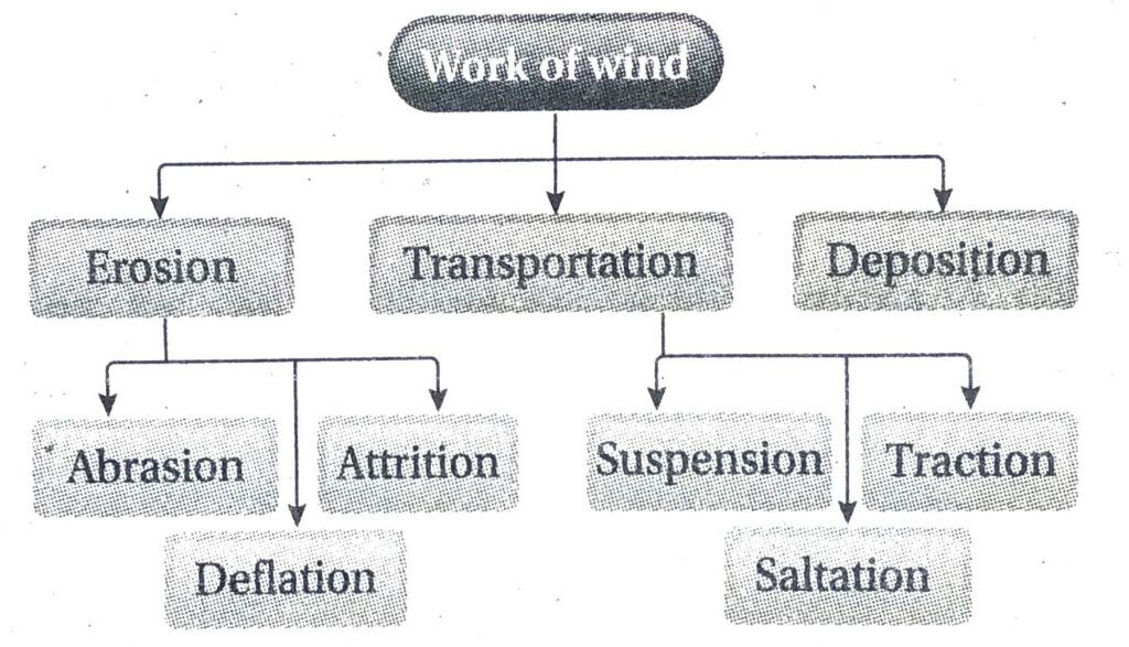
- Erosion: Wind carries out erosion by the following processes-
- Abrasion: The wind carries particles of rocks, pebbles, sand, etc., of different sizes along with it as it blows. These particles collide with the landforms on the earth’s surface and create scratch marks, hollows and furrows. Erosion by this process is called abrasion. Landforms formed due to abrasion are-mushroom rocks, yardang, zeugen, ventifact, dreikantar, etc.
- Deflation: In the process of deflation, the wind blows away sand and smaller rock particles from one place to another. Landforms formed by deflation are-blow outs, pavements, etc.
- Attrition: The rock fragments, pebbles, etc., present in the blowing wind collide with each other and break into smaller fragments and finally convert into sand particles. The process of this breaking down of rock fragment into fine particles of sand due to their collision with each other is known as attrition.
- Transportation: Wind transports the broken rock fragments and other finer particles by the following methods-
- Suspension: The small and light particles of sand and dust remain suspended in the air and are thus transported to long distances by wind.
- Saltation: The medium-sized particles of rock fragments are heavy and cannot be transported in suspension. Even if lifted by the wind, they are carried to shorter distances and dropped on the ground wherever the wind is obstructed.
- Creeping: The larger particles of rock fragments cannot be lifted by the wind due to heavy weight. They are dragged along the surface while the wind blows. This method of transportation is known as creeping.
- Deposition: Any hindrance in the form of trees, bushes, rocky boulders, etc., in the path of the blowing wind may affect the velocity of the wind. As a result, the sand and broken rocky fragments being carried to distances are dropped wherever they are obstructed. These sand accumulations grow in dimension and form several depositional features. Example-Various sand dunes, loess plains, etc.
4. Why are the deserts of the world facing severe expansion? Suggest remedial measures to prevent this.
Ans. At present, the deserts of the world are facing severe expansion.
The reasons leading to such an event are as follows-
- Migration of dunes: Migration or shifting of sand dunes cause the expansion of deserts. Dune migration is harmful as vast regions of agricultural field, grazing land, human settlement, etc., are buried under huge heaps of sand.
- Overgrazing: The areas adjacent to the desert receive more rainfall than the desert regions. Thus, it leads to the growth of grasslands. In the absence of agricultural activities the people of the desert region take to cattle rearing. Over grazing of animals on these grasslands turn these adjacent areas also into deserts.
- Rampant cutting down of trees: Indiscriminate felling of trees in the areas adjacent to the desert regions, leads to the expansion of deserts.
- Unscientific methods of cultivation: Following unscientific methods of cultivation in the areas adjacent to the deserts affects the fertility of these regions. As a result, the adjacent areas are also turned into deserts.
- Drought: Areas adjacent to the deserts when affected by frequent droughts, turn into deserts. The watertable in these regions is severely lowered and the vegetation also stands affected.
- Global warming: Worldwide increase of temperature due to global warming has affected the temperature, amount of rainfall received, etc., of the regions adjacent to the desert. Decreased amount of rainfall received and high temperatures are turning the adjacent areas into a desert.
Measures to prevent expansion of deserts are as follows-
- Afforestation: Planting of trees suitable to the desert environment along the margins of the desert and in the areas adjacent to the desert.
- Controlled grazing: Overgrazing should be checked in the areas adjacent to the deserts.
- Other sources of fuel: Use of wood as a source of fuel should be reduced. Alternative sources of fuel should be looked for.
- Scientific methods of cultivation: To carry out agricultural activities in the desert regions drought resistant crops should be grown using modern methods of irrigation.
- Conservation and judicious use of water: Rainwater harvesting should be extensively practised in the areas adjacent to the desert to mitigate the problem of water shortage. Judicious use of water should also be promoted.
Short Explanatory Answer Type Questions
1. Write down the characteristics of barchans.
Ans. The dunes formed transverse to the direction of the blowing wind in the shape of a crescent, is known as a barchan.
Characteristics:
The characteristics of barchans are listed below-
- The windward slope of the barchan is gentle and convex while the leeward slope is steep and concave.
- The edges of the barchan look like two horns on either side of the crescent.
- Barkhans are usually 15-30m high. Some barkhans may be as high as 200m.
- A number of barkhans may develop like a chain in plain region in the desert. However, they are all temporary and may shift with the change in wind direction.
- Barchans advance on a regular basis at a constant rate when the sand supply is adequate.
2. Write the characteristics of seif dunes.
Ans. The long, narrow sand dunes formed parallel to the direction of wind in a desert region, are called seif dunes.
Characteristics:
- Seif dunes can be few kilometers long and few hundred metres high.
- A number of seif dunes may be formed parallel to each other.
- Sometimes, due to very speedy winds, the middle portion of the barchans may get eroded or blown away, and the horns at the edges of the barchans may get transformed into seif dunes.
- The gap between two adjacent seif dunes is a called corridor. Wind blows at a great speed through these corridors.
- The top of the seif dunes are sharp and are like saw-teeth.
3. Why is the work of wind predominant in the desert regions?
Ans. The work of wind is predominant in the desert regions because of the following reasons-
- Range of temperature: The diurnal and annual ranges of temperature are high in deserts. Thus, the rocks are broken down into small particles and finally into sand by the various mechanical methods of weathering. These small particles are light and are easily lifted by the wind. The wind erodes materials as well as deposits them at other places.
- Lack of rainfall: Lack of rainfall results in fewer trees or plants in the deserts. Thus, there is no obstruction for the winds to blow and they cause erosion and deposition of materials. Thus, lack of vegetation cover in deserts make the winds more active and powerful.
4. What is a loess plain?
Ans. The yellowish fine sandy particles blown off from the desert regions and deposited elsewhere are known as loess. The particles of loess are fine textured and rich in quartz silt,clay and carbonate minerals.
The fine textured soil particles are blown away from the deserts and the outwash plains and deposited at distant regions, forming a new landform known as a loess plain. Example-In central Asia, every year, heavy amount of sandy soil is eroded from the Gobi desert by the north-east monsoon winds. They are deposited in the Hwang Ho river valley of northern China. This
forms a loess plain. The depth of the plainland thus formed is 30-200m. Examples of other loess plains are-loess plain formed in the southern region of Israel by blowing of the soil from the Sahara desert region of Africa; loess plain formed in the Mississippi-Missourie river basin in USA, etc.
5. Differentiate between yardang and barchan.
Ans. The differences between yardang and barchan are as follows-
6. Describe three landforms formed due to deflation of wind.
Ans. The landforms formed by deflation of wind are-
- Deflation hollows: In desert regions, due to high wind speed, sand being continuously removed from a place creates several small and big hollows or depressions on the ground. These are called deflation hollows or blow outs. In Rajasthan they are locally known as Dhand.
- Oasis: At times the depressions formed due to the deflation action of the wind become so deep that their depth reach the underground watertable. As a result, the sand over there becomes a little moist and due to the presence of water, few trees and plants grow around the region. Such a landscape is known as an oasis.
- Desert Pavements: These are extensive stretch of stony surfaces formed in the desert due to the deflation of the wind. Pavements consists of angular or rounded rocky fragments in a matrix of finer sand, silt and clay sized materials. They are locally known by various names at various places. In the Sahara desert they are known as reg or hammada.
7. Where is the erosional action of wind most predominant?
Ans. In arid regions of the world where the rainfall received is less than 25cm, growth of natural vegetation is negligible or almost absent the erosional action of the wind is most predominant.The land surface remains open and uncovered. There are almost no obstruction to the blowing wind. Hence the winds blow at a great speed. Also, the high diurnal range of temperature leads to the disintegration of rocks. These rock fragments are carried with the wind further eroding the landscape by the process of abrasion.
8. Why is the action of wind also active in the coastal regions?
Ans. Action of wind is highly active in the coastal regions because-
- Extensive coastline: The sea breeze blowing over the open seas come towards the land and blow away the sand from the coast. Thus, the open and extensive coastline assist in the erosional and depositional works of the wind.
- Sea waves: The sea waves splash against the coast continuously, and tend to break the rocks and stones into tiny particles, that can be easily blown away by the wind.
- Deposition of sand: The sand present along the coast can be blown away, carried and deposited elsewhere, when the winds are obstructed and lose speed. These landforms are called sand dunes. Example-Such dunes can be seen in Digha and Contai region of West Bengal.
9. How is sand formed in the deserts?
Ans. In the desert regions, the diurnal and annual ranges of temperature are very high. This enhances weathering by mechanical methods, where the large rocks are gradually broken down into small rock fragments. Also, abrasion of rocks leads to further break down of rocks into sand particles. Lack of rainfall helps to speed up the whole process. Thus, sand is formed in the deserts.
Short Answer Type Questions
1. What are wadis?
Ans. The small, shallow dry river valleys found in the deserts are called wadis. The wadis remain dry for most of the time, and get filled at times of suden rain in the desert. They often shift from one position to another or get lost in the sand. Eg.- Wadi Al-Batin of Saudi Arabia is a famous wadi.
2. What do you mean by a pediment?
Ans. In desert regions, the winds are the strongest agent of erosion. The small rocks, pebbles, sand particles etc., that blow with the wind help in eroding large boulders or mountains to low landforms. A pediment is
a plain formed at the foothills of mountains in a desert by the joint action of erosion and deposition by wind as well as flowing water. It remains covered with rocks and boulders.
3. What are dunes?
Ans. In deserts, the winds are very strong and can lift and carry large amounts of sand as they blow. But if the winds are obstructed by trees, rocks, boulders, bushes, hillocks, etc., they lose speed and drop the sand at the place of obstruction. Thus, the sand gets accumulated as high dumps over long stretches of land. These landforms are known as sand dunes. Dunes also form due to the presence of a dominant direction in which the wind blows.
4. What is a barchan?
Ans. The barchan is a transerve sand dune that is found in the desert region. It stands across the direction of wind. It looks like a crescent moon. The middle part of the barchan can be 15-30m high. It has two horns on either side which move forward as the wind blows.
5. What is a hammada?
Ans. Hard rocky sand free surface in a desert is known as a hammada. It is formed when the sand has been blown away by winds.
6. Where are sand dunes found?
Ans. Sand dunes are found in regions that have huge accumulations of sand, some thorny bushes acting as obstructions and vast open lands. Such conditions are found in hot dry desert regions and coastal regions.
7. What is a gara?
Ans. In a desert region, the wind is the most active agent of erosion. The wind erodes mainly by the process of abrasion, where the rocks and pebbles carried by the wind collide against the lower parts or base of a high boulder or a hill. The soft rocks at the base get eroded faster and the hard rocks on the top remain as it is. Thus, the landform develops a narrow base and a broad top. This looks like a mushroom and thus is known as a mushroom rock. Such mushroom rocks are known as gara in the Sahara region.
8. What is loess?
Or, Define Loess.
Ans. Loess are the the yellowish soil particles that are blown by the wind from the deserts and deposited elsewhere. Loess contains particles that are very fine textured and rich in quartz silt, clay and carbonate minerals. The soil particles do not have any similarity with the rocks and soil present in the region where they have been deposited. The plains formed of the loess deposits are called loess plains.
9. What is an oasis?
Ans. In desert regions, a huge depression may be created due to blowing away of sand by the wind regularly. The depression becomes so deep that the surface of the region reaches the level of underground watertable. Thus, water is easily available here, and the soil remains moist. This region is known as the oasis, as the availability of water helps in the growth of trees around the depression and makes this region look green. An oasis is like a garden in the desert region.
10. What are ventifact and dreikanter?
Ans. Ventifact: In a desert region, if wind blows from one direction, the large rocks are polished on one side (the side facing the wind) by the process of abrasion, while the other sides remain uneven and rough. Such a rock is known as a ventifact.
Dreikanter: If wind blows from different directions, all the faces of the rocks standing out are polished by the process of abrasion. Thus, a landform with three polished faces is formed. This is known as dreikanter.
11. What is a dhrian?
Ans. In desert region, due to change in the direction of, winds, the sand dunes shift from one place to the other. These moving or shifting dunes are called ‘dhrians’ in the desert region of Rajasthan.
12. What are seif dunes?
Ans. ‘Seif’ means sword in Arabic. The long and narrow dunes like swords formed in the deserts are called seif dunes.
The seif dunes are formed in sandy deserts parallel to the direction of the wind. These are practically the longitudinal dunes. According to scientist Bagnold, the barchans in the desert region get gradually converted to seif dunes.
13. What are blowouts or deflation hollows?
Or, How are the “deflation hollows” formed?
Ans. Blowouts or deflation hollows are sandy depressions found in the desert regions. They are formed by the removal of sand from a region by wind. They are commonly found in arid regions or coastal regions where there is sufficient sand cover. Example-Qattara Depression, Egypt.
14. What do you mean by playa lakes?
Ans. The salt water lakes found in desert regions are called playa lakes. They are known as ‘dhand’ in Rajasthan and ‘shatts’ in Sahara. The ephemeral streams that originate from the surrounding mountains drain into these lakes. The non-perennial rivers of the desert region may also drain into these playa lakes.
15. What is a bajada?
Ans. The gently sloping plain land lying between the pediment and the playa in a desert region is called a bajada. It may be formed at the foothills of mountains by accumulation of clay, silt and pebbles. The alluvial cones formed at the foothills of mountains in a fluvio aeolian environment may join with each other and form a bajada.
16. Why does abrasion occur at a height of few metres above the earth’s surface?
Ans. Abrasion is the process in which the rock pieces, pebbles and sand blown by the wind rub against or collide against the rocky hills or walls on the earth surface and thus erode them. Abrasion occurs only till a few metres above the ground because the large rock pieces cannot be lifted too high above the ground by the winds. The presence of erosive tools carried by the wind is maximum at the lower columns of air than at a height.
17. What are star dunes?
Ans. In the desert regions, winds blows from different directions during different times of the year. Thus, dunes are formed in different directions. Star dunes are formed by variable winds. They grow vertically and do not migrate laterally. A star dune has multiple slip faces, a central peak and three or more arms extending radially.
18. What do you mean by gassi?
Ans. The seif dunes lie parallel to one another and the gap or passage between two adjacent seif dunes is called a corridor. These corridors are devoid of sand and lie as pavements or vast stony plains in the desert. These are called reg. Such reg or corridors between parallel dunes are known as gassi in Sahara, Africa. These corridors are used as caravan paths for travelling through the deserts.
19. What do you mean by erg?
Ans. The vast stretches in the desert made up of sand accumulations are known as ergs. Ergs are formed where the wind is most active and the amount of sand present is huge. These depressions of wind accumulations were formerly filled with alluvium.
20. Name some deserts of the mid-latitudes.
Ans. Some deserts of the mid-latitudes are-Gobi, Taklamakan and the desert of Turkestan in Asia, the Colorado desert in North America, etc. The number of deserts in mid-latitudes is more than the number of deserts in low latitudes.
21. Name some deserts of the low latitudes.
Ans. The low latitude deserts are found within 20°-30° latitudes in both the hemispheres. These deserts have developed on the western margins of the continents. E.g.- Sahara, Kalahari in Africa; Arabian desert, Baluchistan desert and Thar desert in Asia; Soneran in North America, the Great Australian desert in Australia, etc.
22. What is an adobe?
Ans. In North America, loess deposits are found in the valleys of the Mississippi and Missourie rivers. The scientists believe that, this landform had been formed in the Pleistocene Age when sand from the moraines and outwash plains were blown off and deposited here. These loess deposits are known as adobe in North America. Loess is extensively found in Nebraska, Illinois, lowa, etc.
Multiple Choice Type Questions [MCQ type]
1. The shifting dunes of Rajasthan are locally known as-
A. Dhrian
B. Dhand
C. Barchan
D. Seif
Ans. A
2. Cresentic dunes are called-
A. Seif
B. Barchan
C. Loess
D. Blow out
Ans. B
3. Pediments are formed by the …….. work of wind and temporary streams-
A. Erosional
B. Transportational
C. Depositional
D. Erosional and depositional
Ans. A
4. Salty water is found in-
A. Playa lakes
B. Oxbow lakes
C. Corrie lakes
D. Crater lakes
Ans. A
5. The hard rocks standing like domes or hills in a desert are called-
A. Mushroom rocks
B. Inselbergs.
C. Yardangs
D. Bajada
Ans. B
6. The dunes lying parallel to the direction of wind are called-
A. Barchans
B. Longitudinal dunes
C. Tranverse dunes
D. Whaleback dunes
Ans. B
7. A landform formed by depositional work of winds is-
A. Flood plains
B. Loess plains
C. Outwash plains
D. Delta
Ans. B
8. ‘Gara’ is formed by the action of-
A. River
B. Glacier
C. Wind
D. Waves
Ans. C
9. The depressions created by blowing away of sand in the Marusthali region of Rajasthan are locally called-
A. Dhand
B. Oasis
C. Reg
D. Hammada
Ans. A
10. Barchans get gradually converted to-
A. Akle dunes
B. Seif dunes
C. Gara
D. Wadi
Ans. B
11. The works of wind are together known as-
A. Aeolian processes
B. Fluvial processes
C. Glacial processes
D. Fluvioglacial processes
Ans. A
12. Marusthali means-
A. Land of the dead
B. Rainshadow region
C. A land of heavy rainfall
D. Land of Camels
Ans. A
13. The rock with as many as eight abraded faces is called a-
A. Dreikanter
B. Yardang
C. Zweikanter
D. Ventifact
Ans. D
14. Mesas are eroded further to form-
A. Zeugen
B. Butte
C. Inselberg
D. Yardang
Ans. B
15. The dras dunes resemble the shape of a-
A. Whaleback
B. Parabola
C. Star
D. Barchan
Ans. A
16. The dry river valleys of the deserts are called-
A. Bajada
B. Playa
C. Gassi
D. Wadi
Ans. D
17. Loess plains are known as …….. in France ……..
A. Limon
B. Adobe
C. Hwangtu
D. Löss
Ans. A
18. Yardangs are seen in ………. regions …….
A. Amid
B. Wet
C. Temperate
D. Frigid
Ans. A
19. The dome-shaped low hills present in the peneplain regions are called-
A. Monadnocks
B. Gara
C. Yardang
D.Till
Ans. A
20. Rocky sand free bare surfaces are called-
A. Hammada
B. Bajada
C. Playa
D. Dhrian
Ans. A
Fill in the blanks with suitable words
1. Loess comes from a German word meaning ……….
Ans. Loose materials
2. In desert regions, ………. are formed due to the presence of rocks in a tabular form.
Ans. Zeugen
3. The rock covered plain formed at the foothills of mountains in desert regions due to combined action of wind and flowing water is called ………..
Ans. Pediment
4. The ……… dunes have two horns and look like a crescent moon.
Ans. Barchan
5. The salt lakes of Marusthali region are known as ……….
Ans. Dhand
6. The salt lakes of desert are known as …………
Ans. Playa
7. Whaleback landforms are also known as ………..
Ans. Draas
8. The work of ……….. is predominantly seen in desert regions.
Ans. Wind
9. The city of ……….. has developed in an oasis.
Ans. Riyadh
10. ……….. has its origin in the Arabic word meaning ‘sword’.
Ans. Sief
11. Thick loess deposits are found in ………. India.
Ans. Madhya Pradesh
12. The desert lakes in Sahara are known as ………..
Ans. Shatts
13. Oases are formed by ………. action of wind.
Ans. Erossion
Answer in one or two words
1. Which shape do the sharp and pointed yardangs tend to look like?
Ans. Needle.
2. Which is the largest desert of the world?
Ans. Sahara.
3. What is the space between two seif dunes called?
Ans. Corridor.
4. Where is the largest loess depositions found in the world?
Ans. Hwang Ho valley of China.
5. What does the word ‘butte’ mean?
Ans. Hillocks or domes.
6. Where is the work of winds predominant?
Ans. In desert regions and coastal regions.
7. What are straight dunes also known as?
Ans. Seif dunes.
8. Which is the deepest blowout in the world?
Ans. Qattara in Egypt.