WBBSE 10th Class Social Science Solutions Geography & Environment Chapter 2 Atmosphere
West Bengal Board 10th Class Social Science Solutions Geography & Environment Chapter 2 Atmosphere
WBBSE 10th Class Geography & Environment Solutions
TOPIC – 1
Concept, Composition and Layers of the Atmosphere
Long Answer Type Questions
1. Discuss the influence of the various components of the atmosphere.
Ans. The different components of the atmosphere influence the environment in many ways-
- Nitrogen (78.08 %): (1) The leguminous plants fix the atmospheric nitrogen into the soil with the help of bacteria like Rhizobium, and make the soil fertile. (2) Atmospheric nitrogen is extracted to manufacture chemical fertilisers. (3) The atmospheric nitrogen meets the demand of nitrogen of plants and animals directly or indirectly.
- Oxygen (20.94%): (1) Oxygen helps in respiration, without which no life on earth can survive. (2) Oxygen causes weathering of rocks containing iron, by the process of oxidation. (3) Combustion is possible only in the presence oxygen.
- Carbon dioxide (0.03%) : (1) Carbon dioxide helps to conduct photosynthesis in plants to produce food or glucose. All animals are directly or indirectly dependent on plants for food. (2) It influences the temperature of the atmosphere. (3) The rocks rich in calcium carbonate are weathered by carbon dioxide and water by the process of carbonation. (4) Several landforms like stalactites and stalagmites are formed in limestone regions due reaction with carbon dioxide.
- Ozone: The ozone layer lies within the stratosphere at an altitude of 20-40km above the earth’s surface. It prevents the harmful ultraviolet radiation from reaching the earth’s surface and causing severe diseases like skin cancer, eye problems, infertility, wilting of leaves of plants, etc.
- Water vapour: (1) Water vapour leads to the formation of clouds and rainfall. (2) Life on the earth would have been impossible without the presence of water. All plants and animals need water to survive. (3) Precipitation occurs due to presence of water vapour in the atmosphere.
- Dust particles: (1) The dust particles act as the medium of condensation of water vapour in order to create clouds and fog. (2) The dust particles absorb heat directly from solar radiation and make the atmosphere warm. (3) The dust particles act as prisms and cause refraction of light. Thus, the earth appears so bright and beautiful. (4) Dawn and dusk are created in the sky due to the presence of dust particles in the atmosphere.
Short Explanatory Answer Type Questions
1. Name the components of the atmosphere.
Ans. The atmosphere is made up of three types of components-1. Gases, 2. Water vapour and 3. Dust particles.
- Gases: The atmosphere mostly contains nitrogen (78.08%) and oxygen (20.94%) gases. Other gases present in the atmosphere are-argon (0.93%), carbon dioxide (0.03%), helium, hydrogen, krypton, methane, neon, ozone, xenon, etc.
- Water vapour: The water vapour is an important component of the atmosphere.
- Dust particles: Dust particles, ash particles, sea salt nuclei, etc. are present in the lower layers of the atmosphere, which play a vital role in heat absorption, condensation of water vapour and occurrence of rainfall.
2. Discuss the importance of nitrogen gas in the atmosphere.
Ans. By volume, nitrogen constitutes about 78.08% of the atmospheric gases. The importance of nitrogen is-
- Nitrogen requirement of plants and animals: Animals do not use nitrogen directly. Some pulses fix the atmospheric nitrogen in their root legumes with the help of some bacteria like Rhizobium. Animals take in these leguminous plants as their food and meet their demand of nitrogen.
- Increase in soil fertility: The leguminous plants like pulses, peas, etc. fix the atmospheric nitrogen with the help of bacteria like Rhizobium in the soil. This helps to increase the soil fertility. During agriculture, the fertility of soil can be brought back by cultivating such leguminous plants in between other crops.
- Fertilisers: Nitrogen compounds are often used to produce fertilisers that enhance plant growth.
3. Discuss the importance of oxygen in the atmosphere.
Ans. By volume, the atmosphere contains about 20.94% of oxygen. The importance of oxygen is-
- Survival of life: Life cannot be survived without oxygen for both plants and animals. Thus, if there would have been no oxygen in the atmosphere, there would have been no life.
- Atmospheric balance: Increase or decrease of the amount of oxygen in the atmosphere may disturb the atmospheric balance.
- Weathering: Rocks containing iron are weathered by the oxygen present in the atmosphere by the process of oxidation.
- Combustion: Oxygen helps in combustion and burning of fire. Thus, without oxygen no fire could have been lit.
4. Discuss the importance of carbon dioxide in the atmosphere.
Ans. Although there is only about 0.03% of carbon dioxide in the atmosphere, it is very important in the following ways-
- Preparing food: Carbon dioxide is necessary for photosynthesis and preparation of food (glucose) by plants. All animals are directly or indirectly dependent on plants for food. Therefore, carbon dioxide is necessary for preparing food for all living things.
- Influence on temperature: Carbon dioxide is a greenhouse gas that absorbs much heat. Thus, it plays a vital role in influencing temperature of the atmosphere.
- Weathering: Rocks containing calcium carbonate (e.g. limestone) are chemically weathered with the help of carbon dioxide by the process of carbonation.
- Structure of minerals: Carbon dioxide helps in the formation of crystals and the structure of various minerals.
- Control of environmental pollution: Increase in the amount of carbon dioxide in the environment causes severe pollution and environmental degradation. Thus, it is essential to keep the amount of carbon dioxide in the environment under control.
5. Discuss the importance of water vapour in the atmosphere.
Ans. The importance of water vapour in the atmosphere is-
- Influence on rainfall: The presence of water vapour in the atmosphere leads to precipitation of different forms (such as, rainfall, snowfall, fog, dew, hailstorm, etc.). Amount of precipitation is directly proportional to the amount of water vapour present in the atmosphere.
- Sustaining life: Life is impossible without water. The presence of water vapour in the atmosphere helps to cause rainfall and hence, helps to sustain life on the earth.
- Control on climate: The climate of a region is dependent on the amount of rainfall, snowfall, drizzle, fog, cloud, dew or hailstorm occurring in the region. The climate is humid in regions that receive heavy rainfall, climate is of dry desert type in regions that receive scanty rainfall.
6. Discuss the importance of dust particles in the atmosphere.
Ans. The importance of dust particles in the atmosphere is-
- Cloud formation: The water vapour condenses around the dust particles to form clouds and different forms of precipitation occur from them.
- Distribution: The dust particles get heated directly by the insolation, hence makes the atmosphere warm. Thus, presence of dust particles influence the distribution of solar heat in the atmosphere.
- Colour of the sky: The dust particles act as prisms and cause refraction of light. Thus, the sky appears colourful at times. The excess of blue light in the colour spectrum makes the sky appear blue.
7. How is the ozone layer being depleted?
Ans. The ozone gas is concentrated in the stratosphere. It is being depleted fast by photo-chemical reactions. The causes of depletion of ozone layer are as follows-
- Influence of CFCs: The chlorofluoro-carbons in refrigerators, air conditioners, body sprays, cosmetics, hair sprays, insecticides and pesticides are responsible for the depletion of the ozone layer. The ultraviolet rays of the sun release the chlorine molecules from the CFCs which react with the ozone and deplete it.
O3 + Cl → CIO + O2
- Sulphate compounds: The chimneys of various factories emit huge quantities of sulphur dioxide. These are converted to sulphate compounds by sunlight and harm the ozone layer.
- Aeroplanes: The jet planes that fly through the stratosphere emit a lot of nitrogen oxide. This is harmful for the ozone layer.
8. Mention the general characteristics of air.
Ans. The general characteristics of air are- 1. Air becomes heavy and dense if temperature decreases. 2. Rise in temperature expands the air, makes it light and causes it to rise. 3. Warm air has more moisture holding capacity than cool air. 4. Increase in amount of water vapour in the air reduces air pressure. 5. Moist air is lighter than dry air. 6. Warm air is lighter and rises upward, while cool air is heavier and sinks downward. 7. Density of air is maximum near the earth’s surface, and goes on decreasing with increase in height.
9. Why would life not have been created if the atmosphere was absent?
Ans. Life would not have been created in the absence of atmosphere because-1. In the absence of the atmosphere, the day temperature of the earth would have been 70°C and night temperature would have been- 145°C. Life cannot survive in such extreme temperature conditions. 2. Oxygen and carbon dioxide present in the atmosphere indispensable for sustaining life. 3. Water vapour present in the atmosphere condenses to give rainfall. The first proofs of life originated in water. Hence, if there would have been no rainfall, there would have been no life. 4. The ozone gas present in the atmosphere protects the earth from the harmful ultraviolet rays of the sun, thus saving life on the earth.
10. What may happen due to the creation of the ozone hole?
Ans. Importance of ozone layer: The ozone layer protects the earth like an umbrella from the harmful ultraviolet rays of the sun. It saves the plant and animal life from decay and diseases.
Consequence of ozone hole: Creation of ozone hole will allow the harmful ultraviolet rays of the sun to enter the earth’s atmosphere. This will cause several diseases like skin cancer, damage of cornea of eyes, infertility, skin diseases, death of fishes and other aquatic life, wilting of leaves of plants, etc.
11. Write the effects of depletion of ozone layer.
Ans. The ozone layer is being gradually depleted by the CFCs, nitrogen oxide, sulphate compounds, etc. The effects of ozone layer depletion are-
- On climate: The depletion of the ozone layer allows the harmful ultraviolet rays of the sun to enter the earth’s atmosphere. This causes global warming, which further leads the depletion of ozone layer.
- On human beings: The depletion of ozone layer causes skin cancer and other skin diseases, reduces fertility, damages the cornea of the eyes, etc.
- On ecosystem: The ecosystem is also hampered due to ozone layer depletion. Plants lose productive capacities. Many small animals may get extinct.
12. Why do jet planes fly through the stratosphere?
Ans. The jet planes fly through the stratosphere because-1. The stratosphere is free of water vapour and weather phenomena like winds, thunder storms, rainfall, etc. The very fine dust particles present here do not hamper the flying of planes. 2. This layer is practically devoid of air and there is very little friction and no disturbances in the atmosphere. 3. The presence of jet streams in the tropopause also helps in saving costly aviation fuel because jet streams propel jet planes to fly easily following them.
13. How is the ozone layer contracting?
Ans. The excessive emission of chlorofluorocarbons, nitrogen oxide, sulphur dioxide and other greenhouse gases is harming the ozone layer. Big holes have been detected in this layer especially, over the Antarctic region. According to the scientists, creation of ozone holes may lead to diseases such as skin cancer, damage of cornea of eyes, etc. due to the ultraviolet rays reaching the earth’s surface.
14. Why does temperature decrease with increase of altitude in Troposphere?
Ans. Temperature decreases with increase of altitude in Troposphere at the rate of 6.4° C with every 1000 m altitude. This is known as normal lapse of temperature. This happens because of the following reasons-
- Less radiation received: The atmosphere does not get heated directly. It gets heated up by the radiation received from the surface of the earth. Thus, the lower part of the atmosphere coming in direct contact with the surface of the earth gets more heat than the portion lying above.
- Less denser air: The layers of air are denser near the earth’s surface and become lighter with increasing altitude. Hence, upper layers receive less heat.
- Less heat absorbing capacity: The lower layer of the atmosphere contains more water vapour, dust particles, sea salt nuclei than the layers above and hence heat retentive and heat absorbing capacity considerably decrease with increase of altitude.
- Thin layer of air: The atmosphere gradually thins out with increase of altitude. For this reason, air in the upper layers expands quickly and cools rapidly by release of radiation.
Short Answer Type Questions
1. What do you mean by the atmosphere?
Ans. The atmosphere is a thick blanket of air that surrounds the earth. It stretches up to 10000 km above the earth’s surface, and remains attached to the earth due to its gravitational pull. The major gases present in the atmosphere are-nitrogen (about 78.08%), oxygen (about 20.94%), argon (0.93%), carbon dioxide (0.03%), helium, hydrogen, krypton, methane, neon, ozone, xenon, etc. Apart from these gases, the atmosphere also contains water vapour, dust particles and sea salt nuclei.
2. How far does the atmosphere extend over the earth’s surface?
Ans. The atmosphere extends up to about 10000 km above the earth’s surface. But about 97% of the total atmospheric mass is concentrated within 29 km of the whole stretch. This part of the atmosphere has the greatest density as the greatest concentration of the gases occur here due to the earth’s gravitational pull.
3. What is the tropopause?
Ans. The troposphere stretches up to 18 km above the equator and 8 km above the poles. Above this layer lies a very thin layer where temperature neither increases nor decreases. This is known as the tropopause, which stretches for 2.5-3 km thickness above the troposphere. The tropopause marks the boundary between the troposphere and the stratosphere.
4. What is the importance of ozone gas in the atmosphere?
Ans. The ozone gas is very important because-
- Protection from harmful ultraviolet rays: The ozone layer absorbs the harmful ultraviolet rays coming from the sun. Thus, it protects us from dreaded diseases like cancer.
- Control of air temperature: The ozone layer also plays a vital role in controlling temperature of the lower layers of the atmosphere. It helps to prevent global warming.
5. What do you mean by the homosphere?
Ans. The homosphere refers to the portion of the atmosphere where the composition and other characteristic features remain almost homogeneous. It stretches up to 90 km from the surface of the earth. The chemical composition of the atmosphere, especially the proportion of nitrogen, oxygen, carbon dioxide, argon, helium, etc. remain more or less constant in this region.
6. What do you mean by the heterosphere?
Ans. The heterosphere refers to the portion of the atmosphere where the composition and other characteristic features do not remain homogeneous. It stretches from 90km to about 10000 km above the earth’s surface. The ratio of the gases found in this region is not similar everywhere. The heterosphere can be divided into four sub-layers-1. Molecular nitrogen layer (90-200 km); 2. Atomic oxygen layer (200-1100 km); 3. Helium layer (1100-3500 km) and 4. Atomic hydrogen layer (3500-10000 km).
7. What is the troposphere?
Ans. The lowest layer of the atmosphere lying adjacent to the earth’s surface is known as the troposphere.
Extent: The troposphere extends up to 8km above the poles and 18 km above the equator.
Characteristics: 1. Temperature of the troposphere decreases by 6.4°C for every 1000 m rise in altitude. This way the temperature of the uppermost part of the troposphere reaches -57°C to -60°C. 2. The greatest density of the atmospheric gases is found in this layer. The water vapour and dust particles present here help in the formation of clouds. All weather phenomena such as winds, humidity, rainfall, change in air pressure, etc. only occur in this layer.
8. What is the stratosphere?
Ans. The layer of the atmosphere lying above the tropopause is known as stratosphere.
Extent: It stretches over the tropopause up to 50 km from the earth’s surface.
Characteristics: 1. Temperature of the stratosphere increases with rise in altitude. At the upper limit of the stratosphere, the temperature reaches about -4°C. 2. The upper limit or margin of the stratosphere is known as the stratopause, which separates this layer from the next layer called the mesosphere. 3. The ozone layer is present within the stratosphere. This is one of the causes of increase in temperature of the stratosphere.
9. What is the mesosphere?
Ans. The layer of the atmosphere lying above the stratopause is known as the mesosphere.
Extent: It extends above the stratopause up to 80 km from the earth’s surface.
Characteristics: 1. Temperature of this layer increases with increase in altitude. 2. The upper limit of the mesosphere is known as the mesopause. Temperature remains around-93°C in this part. 3. The meteors that enter the earth’s atmosphere get burnt in the mesosphere due to friction with the air.
10. What is the ionosphere?
Ans. The layer of the atmosphere lying above the mesosphere is known as the exosphere. The density of air is very less here, and the gases present in an ionised form due to very hot solar rays. Due to the presence of ions, this layer is also known as the ionosphere.
11. What is the importance of the ionosphere?
Ans. The importance of the ionosphere-1. The harmful short waves coming from solar radiation every day are absorbed in the ionosphere. 2. The radio waves are reflected in this layer, which help in radio and wireless transmissions. 3. The free electrons created due to ionisation of the gases result in the occurrence of auroras in the polar regions.
12. What is the thermosphere?
Ans. The layer of the atmosphere lying above the mesopause between 80-640 km is known as the thermosphere. Temperature in this layer increases rapidly with rise in altitude, hence it is called the thermosphere. Temperature reaches about 1200°C at the upper limit of this layer.
13. Mention the characteristic features of the exosphere.
Ans. The layer of the atmosphere that lies above the thermosphere beyond 640 km is known as the exosphere.
Characteristic features: 1. The atmosphere is very less dense in this layer. 2. Temperature in this layer increases with increase in altitude. 3. Temperature reaches about 1240°C at an altitude of 650 km above the earth’s surface. 4. The layer lying next to the exosphere is magnetosphere. Here the atmosphere is least dense, beyond which it gradually merges with the outer space.
14. List the components of the atmosphere.
Ans. The atmosphere comprises three kinds of components-1. gases, 2. water vapour and 3. dust particles.The major gases found in the atmosphere are-nitrogen (78.08%), oxygen (20.94%), argon (0.93%), carbon dioxide (0.03%), helium, hydrogen, krypton, methane, neon, ozone, xenon, etc. The other components found in the atmosphere are- water vapour, dust particles, ashes of meteors, aerosols, etc. that remain suspended in the air.
15. What do you mean by lower atmosphere?
Ans. The ratio of the gases present in the atmosphere remain almost same up to 80 km of the atmosphere above the earth’s surface. This is known as the lower atmosphere.
Characteristics: 1. The gravitational pull of the earth causes the gases to concentrate closer to the earth’s surface. Thus this is the densest part of the atmosphere. 2. About 97% of the total mass of the atmosphere is concentrated within 29 km above the earth’s surface.
16. What is the height of the troposphere?
Ans. The troposphere is the lowest layer of the atmosphere. It extends up to 8 km above the poles and 18 km above the equator.
17. What is the normal lapse rate?
Ans. The temperature in the troposphere decreases by about 6.4°C for every 1000m rise in altitude. This rate of decrease of temperature is known as the normal lapse rate.
18. What are aerosols?
Ans. The suspended particles of dust, ash, remains of meteors, burnt particles from factory chimneys, pollen grains, sea salt nuclei, etc. found in the atmosphere are known as aerosols. They are very fine in texture and generally found in a colloidal form.
19. What is the Van Allen radiation belt?
Ans. A Van Allen belt is a radiation belt surrounding the earth of energetic charged particles. These particles which originate from the solar wind that is captured by and held around a planet by the planet’s magnetic field. This belt extends from an altitude of about 1000-60000 km above the earth’s surface. The belt has been named after the eminent physicist James Van Allen, who discovered it. in.1958.
20. What is the isothermal zone in the upper atmosphere?
Ans. The temperature above the thermosphere remains.constant and does not fluctuate too much. This region is the isothermal zone of the upper atmosphere.
21. What is the atomic hydrogen layer?
Ans. The layer of the atmosphere lying between 3500-10000 km is mostly composed of hydrogen atoms. Thus, this layer is known as the atomic hydrogen layer. As altitude increases, the layer goes on becoming lighter and air pressure goes on decreasing.
22. How can depletion of the ozone layer be stopped?
Ans. The depletion of the ozone layer occurs due to chloroflurocarbons (CFCs) produced by the use of refrigerators, air conditioners, body sprays, carbon fuels, etc. Reduction in the use of the these items will help to reduce the depletion of the ozone layer.
23. Name some gases responsible for the depletion of the ozone layer.
Ans. The gases responsible for the depletion of the ozone layer are-chloroflurocarbons (CFCs), nitric oxide (NO), methane (CH4), etc.
24. What do you mean by ‘nacreous cloud’?
Ans. ‘Nacreous clouds’ sometimes known as ‘Mother of Pearl Clouds’ are formed in the stratosphere over Antarctica at a temperature around -85°C. These clouds generally do not cause rainfall.
Multiple Choice Type Questions [MCQ type]
Write the correct answer from the given alternatives
1. By volume, the amount of oxygen present in the atmosphere is-
A. 20.94%
B. 20.27%
C. 20.86%
D. 20.98%
Ans. A
2. The major gas present in the atmosphere is-
A. Oxygen
B. Nitrogen
C. Carbon dioxide
D. Ozone
Ans. B
3. The ozone gas lies in the layer of the atmosphere-
A. Stratosphere
B. Mesosphere
C. Troposphere
D. lonosphere
Ans. A
4. The boundary between the troposphere and stratosphere is known as-
A. Tropopause
B. Stratopause
C. Mesopause
D. lonopause
Ans. A
5. How far does the atmosphere extend over the earth’s surface?
A. 1000 km
B. 5000km
C. 10000 km
D. 100000 km
Ans. C
6. Temperature ……. with increase in height in the mesosphere-
A. Increases
B. Decreases
C. Remains same
D. None of these
Ans. B
7. The homosphere extends up to ……. above the earth’s surface-
A. 60 km
B. 90 km
C. 12 km
D. 110 km
Ans. B
8. The sky appears blue due to presence of ……… in the atmosphere-
A. Ozone
B. Oxygen
C. Dust particles
D. Nitrogen
Ans. C
9. Inversion of temperature occurs in the-
A. lonosphere
B. Troposphere
C. Stratosphere
D. Mesosphere
Ans. B
10. The ultraviolet rays coming from the sun are absorbed by-
A. Ozone
B. Argon
C. Xenon
D. Krypton
Ans. A
11. The rate of reduction of temperature for every 1,000 m increase in altitude is-
A. 6.3°C
B. 4.6°C
C. 6.6°C
D. 6.4°C
Ans. D
12. Temperature decreases by the lapse rate in the-
A. Stratosphere
B. Thermosphere
C. Troposphere
D. Mesosphere
Ans. C
13. By volume the amount of nitrogen present in the atmosphere is-
A. 20.19%
B. 79.09%
C. 78.08%
D. 20.50%
Ans. C
14. An example of greenhouse gas is-
A. Oxygen
B. Nitrogen
C. Carbon dioxide
D. Ozone
Ans. C
15. …….. is also a part of the heterosphere-
A. Mesosphere
B. Troposphere
C. Stratosphere
D. Exosphere
Ans. B
16. The elements of ……… weather are found in the-
A. Mesosphere
B. lonosphere
C. Stratosphere
D. Troposphere
Ans. D
17. The meteors that come towards the earth get burnt in the layer of-
A. lonosphere
B. Stratosphere
C. Mesosphere
D. Exosphere
Ans. C
18. Ozone gas is absorbed in the-
A. Mesosphere
B. Troposphere
C. Stratosphere
D. lonosphere
Ans. C
19. Ozone gas is depleted by-
A. Carbon dioxide
B. Nitrogen
C. CFCs
D. Oxygen
Ans. C
20. Aurora is seen in the-
A. lonosphere
B. Magnetosphere
C. Troposphere
D. Mesosphere
Ans. A
Very Short Answer Type Questions
Fill in the blanks with suitable words
1. The last limit of the troposphere is known as ………
Ans. Tropopause
2. The highest layer of the atmosphere is ………..
Ans. Magnetosphere
3. The water vapour condenses on floating …….. in the atmosphere to form clouds and fog.
Ans. Dust particles
4. Aurora Borealis is seen in the ……… region.
Ans. Arctic
5. The troposphere extends up to ……… km over the earth’s surface near the poles.
Ans. 8km
6. The lowest layer of the atmosphere is …………
Ans. Troposphere
7. By volume, the amount of argon gas present in the atmosphere is ……….
Ans. 0.93%
8. Clouds, storms, thunders, etc. occur in the …………
Ans. Troposphere
9. Gases remain ionised in the ……….
Ans. lonosphere
10. In the troposphere, temperature ……….. with increases in altitude.
Ans. Decreases
11. Jet planes fly through the …………
Ans. Stratosphere
12. The troposphere extends up to ………. km over the equator.
Ans. 18 km
13. The most abundant gas present in the atmosphere is ………
Ans. Nitrogen
14. Auroras are seen in the ……… layer of the atmosphere.
Ans. lonosphere
15. ……… present in the atmosphere help in the occurrence of rainfall.
Ans. Water vapour
16. The word ‘tropo’ means …………
Ans. Change
17. The helium layer extends up to ………
Ans. 3,500 km
18. About …….. % of total atmospheric mass is concentrated within 29 km from the surface upward.
Ans. 97
19. ……… is the magnetic shield of the earth.
Ans. Magnetosphere
20. ……… layer is the natural sun guard of the atmosphere.
Ans. Ozone
Answer in one or two words
1. How far does the atmosphere extend above the earth’s surface?
Ans. About 10000 km.
2. What is the height of the troposphere near the equator?
Ans. 18km.
3. What is the height of the troposphere near the poles?
Ans. 8 km.
4. Which gas is concentrated in the topmost layer of the atmosphere?
Ans. Hydrogen.
5. Which planet other than the earth has an atmosphere that supports life?
Ans. No planet.
6. Why does the atmosphere surround the earth?
Ans. Due to gravitational pull.
7. How does pure air appear to be?
Ans. Devoid of colour, smell and taste.
8. Name the topmost layer of the heterosphere.
Ans. Atomic hydrogen layer.
9. What is necessary in the atmosphere to cause rainfall?
Ans. Presence of water vapour.
10. Which is the most abundant gas in the atmosphere?
Ans. Nitrogen.
11. Name two inert gases present in the atmosphere.
Ans. Argon and neon.
12. Through which layer of the atmosphere do jet planes fly?
Ans. Stratosphere.
13. Which layer of the atmosphere acts like an umbrella for the earth from the solar radiation?
Ans. Ozone layer.
14. Which gas causes rusting of iron?
Ans. Oxygen.
15. How far does the mesosphere stretch above the earth’s surface?.
Ans. 80 km.
16. In which layer of the atmosphere does temperature increase rapidly?
Ans. Thermosphere.
17. Which layer of the atmosphere allows radio broadcasting?
Ans. lonosphere.
18. Name two gases that destroy the ozone layer.
Ans. Chlorofluorocarbons and nitric oxide.
19. Which region of the earth is affected most due to ozone depletion?
Ans. Antarctica.
20. What happens due to ozone depletion?
Ans. Global warming.
21. What is the last limit of the atmosphere and outer space known as?
Ans. Magnetopause.
22. Where is the density of ozone layer greatest?
Ans. At an altitude of 20-40 km.
23. In which layer of the atmosphere jet plane flies?
Ans. Stratosphere.
TOPIC – 2
Heat, Temperature and Global Warming
Long Answer Type Questions
1. Discuss the causes of difference in temperature in the air in different parts of the earth.
OR, Explain the causes of difference in air temperature in the atmosphere.
OR, How is the temperature of the atmosphere influenced by different factors?
Ans. The various causes of difference in the air temperature in different parts of the earth are as follows-

- Latitude: The angle of incidence of sun’s rays is different in different latitudes. The sun’s rays fall almost vertically over the equator and go on becoming tangent over the higher latitudes towards the poles. The tangent rays give less amount of heat for the following reasons- (1) Tangent rays have to cross a larger distance through the atmosphere than the vertical rays. (2) Tangent rays spread over a larger area on the earth’s surface and distribute the heat. Thus, temperature is highest at the equator and goes on decreasing towards the poles.
- Altitude: By the normal lapse rate, temperature decreases by 6.4°C for every 1000 m rise in altitude. Hence, two places located on the same latitude but different altitudes will have different temperature conditions. Eg-Average temperature of the capital of Uganda, Kampala (0°21’N, altitude-1190 m) is 22.7°C, while that of the capital of Ecuador, Quito (1°08’N, altitude- 2850 m) is 15.6°C.
- Presence of mountains: The presence of mountains across the direction of hot or cold winds influence the temperature of the region. Eg-The Himalayan mountains prevent the chilling cold polar winds coming from Siberia from entering India and making it chilled.
- Distance from the sea: The regions close to the sea enjoy a moderate maritime climate, while the places far away from the sea experience harsh, extreme continental climate. Eg- Mumbai lying on the coast of Arabian Sea has an average summer temperature of 33°C and winter temperature of 21°C. On the other hand, Delhi lying far away from the sea has an average summer temperature of 47°C and winter temperature of 12°C.
- Slope of land: The slope which faces the sun receives more solar radiation than the opposite slope, thus they are warmer. Eg- The southern slope of the Himalayas receives direct rays and the northern slope receives tangent rays. Thus, the southern slope is warmer than the northern slope.
- Length of day and night: Length of day and night influences temperature of the places. If length of the day is smaller than the night, the insolation can be totally radiated back during the night, thus making the nights cooler. But if the length of the day is greater than the night, the total insolation cannot be radiated back within the smaller length of night. Some heat remains in the atmosphere and raises the average temperature of the place.
- Cloud cover: The cloud cover prevents solar energy from reaching the earth’s surface during daytime. It also prevents the solar radiation from escaping from the earth’s atmosphere into the outer space during the night. Thus, cloudy nights are more warmer than cloudy days.
- Ocean currents: If warm and cold ocean currents flow along either side of a continent at the same latitudes, the warm current makes the coastal region warm and raises the temperature. The cold current makes the coastal region cooler and drops the temperature. Thus, along the same latitudes, one side of the continent remains warmer than the other side.
- Winds: Prevailing winds influence the temperature conditions of the regions. Eg- The cold winds from the Arctic region reach far into North America and make the climate of USA chilling during winter and cause heavy snowfall. On the other hand, the warm Chinook wind make the Prairies warm and cause the snow to melt.
- Forest: The canopy of leaves and branches in forests prevent solar radiation from reaching the earth’s surface easily. Thus, forested regions are cooler than barren regions.
- Soils: Different types of soils absorb heat differently. The moist clayey soils like alluvium absorbs lesser heat than the dry sandy soils. Hence, places comprising sandy soil are warm in daytime and cool after radiation of heat in the night. The places on comprising moist alluvial soil is moderately warm and cool during the day and night respectively.
- Urbanisation and industrialisation: The smoke emitted by vehicles in cities and towns and the chimneys of the industries increase the general temperature of the environment. Thus, urbanisation and industrialisation tend to increase the average temperature of the regions. Eg-The average temperature of Kolkata always remains 2-3°C higher than the vacant region near the Dum Dum airport.
2. Discuss the characteristics of the temperature zones of the world.
Ans. The earth is divided into five temperature zones according to the difference in temperature. They are as follows-
- Torrid zone
Location: The Torrid zone lies between the Tropic of Cancer (23½°N) and the Tropic of Capricorn (23°S) across the equator (0°). The region is the warmest on the earth as it receives the direct rays of the sun. Sometimes the 30°N and 30°S latitudes are considered as the limits of the Torrid zone. Characteristics: (1) The Torrid zone receives vertical rays of the sun almost throughout the year. (2) Average temperature remains around 27°C. (3) The length of day and night remain equal throughout the year. (4) This zone does not experience any climatic change during different times of the year. Summer is the only season prevailing here.
- Northern Temperate zone and Southern Temperate zone
Location: The northern temperate zone lies between the Tropic of Cancer (23½°N) and the Arctic Circle (66%2°N) and the southern temperate zone lies between the Tropic of Capricorn (23½°S) and Antarctic Circle (66%’S). The average temperatures of these zones vary between 0°C-27°C.
Characteristics: (1) The angle of incidence of sun’s rays is medium in the temperate zones. (2) The length of day and night is variable but medium. (3) The region closer to the tropics is known as the warm temperate zone, while the region closer to the polar regions is known as the cool temperate zone.
- Northern Frigid zone and Southern Frigid zone
Location: The northern Frigid zone extends from the Arctic Circle (66%2°N) to the North Pole (90°N). The sun’s rays are extremely inclined or tangent in this region. Hence, the region is extremely cold.
Characteristics: (1) The difference between length of day and night is extreme in this region. The polar regions experience six months of continuous day and six months of continuous night. (2) The extremely inclined rays of the sun does not provide much heat to the region. The continuous day light for six months is also not sufficient to raise the temperature of the place. (3) During the continuous six months of night, some bright lights can be seen in the sky. These are called Aurora Borealis in the northern hemisphere and Aurora Australis in the southern hemisphere.
3. Discuss the effects of global warming.
Ans. The effects of global warming on the earth are as follows-
- Melting of polar and glacial ice: The gradual increase in atmospheric temperature is causing the ice of the South Pole and the glaciers of Greenland, and other mountain glaciers like Gangotri, Yamunotri, etc to melt.
- Rise in sea level: The melting of ice caps is causing the level of water in the seas to rise. The sea level rises by 10-12 cm for every 1°C rise in temperature. This leads to submergence of coastal lowlands, change in direction of flow of ocean currents, increase in salinity of groundwater, etc.
- Change in the type of precipitation: Rise in temperature increases the level of evaporation and the moisture holding capacity of the atmosphere. This increases the occurrence of rainfall, hailstorms, snowfall, etc. Some regions may be affected by floods, while some regions may face droughts due to uneven distribution of rainfall.
- Crop production: Increase in general temperature of the environment may reduce production of food crops by 10-70%. Production of crops like rice, oats, tobacco, cotton and jute may decline, while production of sugarcane, jowar, bajra, etc. may increase. E.g.-In Kullu Valley, cultivation of onions and others have taken. up the place of apples in many areas.
- Cropping methods: The cropping patterns will change all over the world due to rise in atmospheric temperature. The agricultural lands dependent on irrigation will transform into pastures for grazing. Crops like rice, jute and cotton will be grown in the temperate zone instead of the tropical zone. Methods of cultivation will also change all over the world.
- Effects of El Nino: In the southern hemisphere along the coast of Peru and Ecuador of South America a warm current is suddenly generated in the Pacific Ocean, which raises the temperature of the ocean by 1.5-2.5 °C. This is known as El Nino. This causes heavy rainfall in Peru and Ecuador, but may cause droughts in India.
4. How does altitude influence air temperature?
OR, Why are place in high altitudes cooler?
OR, Why are the mountains cooler than the low plains?
Ans. Temperature decreases by 6.4°C for every 1000 m rise in altitude by the normal lapse rate. Thus, places lying on the same latitude but at different altitudes record different temperatures. E.g.-The capital of Uganda, Kampala (1192 m) is about 7°C warmer than the capital of Ecuador, Quito (2819 m), although they are located almost on the same latitude. This difference in temperature occurs because of the following reasons-
- Radiation in higher altitudes: In the lower altitudes, the combined effect of incoming solar radiation and outgoing terrestrial radiation make the place warmer as compared to the higher latitudinal locations. Most of the heat is absorbed in the lower layers of the atmosphere closer to the earth’s surface. Thus, the temperature goes on decreasing at the upper levels or higher altitudes.
- Less density of air: The density of air decreases as altitude increases. Less dense air has less temperature.
- Less absorption of heat: The lack of dust particles and water vapour in higher altitudes lead to less absorption and retention of heat in the air present there.
- Thin layers of air: The air become thinner with rise in altitude. It radiates heat and becomes cool very fast.
Short Explanatory Answer Type Questions
1. Why are days very hot and nights very cold in hot desert regions?
Ans. The days are very hot and the nights are very cold in hot desert regions because-
- The clear sky in hot desert regions allow the solar radiation to reach the earth’s surface and heat it up fast. Thus, sands present in the desert regions get heated up fast and accordingly heat up the atmosphere. Thus, temperature rises very high during daytime.
- After sun set, the sands of the deserts radiate back heat very fast. Due to clear sky, the heat is released into space very fast and the sands cool down. This makes the nights cold in the hot desert regions.
2. Why are cloudless nights cooler than cloudy nights?
Ans. The cloud cover of the sky prevents the insolation to reach the earth’s surface during daytime and terrestrial radiation of the solar energy into the space in the afternoon. This makes the days comparatively cooler and the nights comparatively warmer in cloudy conditions. On the other hand, if the sky is clear and cloudless, the insolation heats up the atmosphere very much during daytime and the energy is fully radiated back during night. Thus, the days seem to be warmer and the nights seem to be cooler.
3. Mention the factors that influence the heat budget of the earth.
Ans. The amount of solar energy received by the earth, or the heat budget of the earth is maintained by the following factors-
- Angle of incidence of sun’s rays: The lower latitudes receive perpendicular rays of the sun and the rays become inclined as the latitudes increase. Thus, the equatorial region and lower latitudes receive more heat than the higher latitudes and polar regions.
- Distance between the earth and the sun: The earth moves around the sun in an elliptical orbit. Hence, sometimes the distance between the sun and the earth decreases and sometimes increases. This affects the amount of heat received by the earth’s surface.
- Length of day and night: The regions which have longer daytime receive more solar energy than the regions which have longer nights.
4. Why does Mt. Kilimanjaro remain snow-covered even though it is located on the equator?
OR, Why does the capital of Ecuador, Quito have a sub-tropical highland climate?
Ans. Mt. Kilimanjaro is located on the equator and is 5.9 km in altitude. The average temperature of the equatorial region is 27°C. By the lapse rate, the average temperature of the peak of Mt. Kilimanjaro is 27°C – (6.4°C × 5.9) = – 10.76°C. Thus, the Mt. Kilimanjaro remains snow-covered throughout the year.
The capital of Ecuador, Quito is located in the equatorial region at 2.8 km above mean sea level. The average temperature of the equatorial region is 27°C. Thus, by the lapse rate, average temperature of Quito is 27°C – (6.4°C × 2.8) = 9.08°C. Thus, Quito enjoys a sub-tropical highland climate.
5. Why does the water of Baltic Sea freeze but water around the British Isles does not freeze in spite of both lying along the same latitude?
Ans. The latitude at which the British Isles as well as the Baltic Sea lies, makes the region very cold. Thus, it is very natural for water to freeze. But the warm Gulf Stream passing along the coast of the British Isles keeps the water warm and prevents it from freezing during winter. On the other hand, the Baltic Sea is surrounded by land, and no warm current flows through it. Thus, the water becomes very cold and freezes during winter.
6. Divide the earth into different temperature zones.
Ans. The earth can be divided into three parts or temperature zones, according to latitudinal extent-
- Torrid zone: The region extending between the Tropic of Cancer (23½°N) and the Tropic of Capricorn (23½°S) across the equator (0°) is known as the Torrid zone. The average temperature of this region is around 27°C. This zone does not experience much climatic changes throughout the year. Hence, summer persists round the year.
- Temperate zone: The region lies between 23½° and 66½° latitudes in both the hemispheres is known as the temperate zone. It stretches from the Tropic of Cancer to the Arctic Circle in the northern hemisphere and Tropic of Capricorn to the Antarctic Circle in the southern hemisphere. Here, average temperature varies between 0° and 27°C.
- Frigid zone: The region extending between 66½° latitudes and the Poles in both the hemispheres is known as the Frigid zone. It stretches from the Arctic Circle to the North Pole in the northern hemisphere and from the Antarctic Circle to the South Pole in the southern hemisphere. The average temperature is around 0°C.
7. Why do landmasses get heated faster than water bodies?
Ans. Landmasses get heated faster than water bodies because of the following reasons-
- The heat received by water bodies is transferred to the depths by the convectional currents. No such convectional currents work on landmasses.
- Absorption of solar energy is lower over water bodies than landmasses. Thus, the landmasses get heated quicker than water bodies.
- The amount of energy required to heat up per unit volume of water by 1°C is about three times the energy required to heat up per unit volume of landmasses by 1°C. Thus, if same amount of energy is supplied, landmasses get heated faster than water bodies.
- Water being transparent, solar energy penetrates up to 200m depth and distributes the heat. Land being opaque, heat gets concentrated on the surface only.
8. Discuss the causes of global warming.
Ans. The major causes of global warming are-
- Excessive use of fossil fuels: The excessive use of fossil fuels in vehicles, industries and thermal power plants is increasing the level of carbon dioxide in the atmosphere. The gas absorbs much heat and increases the temperature of the earth.
- Emission of methane gas: Methane is a greenhouse gas emitted from wetlands, waterlogged rice fields, decaying organic matter; excreta of domestic animals, etc. This plays an important role in increasing the temperature of the earth.
- Deforestation: Reckless cutting down of trees leads to deforestation. This is gradually increasing the percentage of carbon dioxide in the atmosphere, which is a greenhouse gas. The more concentration of carbon dioxide in the atmosphere is increasing the earth’s temperature and causing global warming.
- Emission of nitrous oxide: Use of nitrogen rich fertilisers in agriculture, forest fires, etc. emit a huge quantity of nitrous oxide (N2O), which leads to global warming.
- CFC gases: Use of refrigerator, air conditioners, electronic gadgets, body sprays, cosmetics, etc. increase the use of chlorofluorocarbons (CFCs) which is one of the major causes of global warming.
9. What is El Nino? Discuss its influences.
Ans. El Nino is a southward moving warm current of the Pacific Ocean which flows along the western coasts of Peru and Ecuador. El Nino causes considerable rise in air temperature of the eastern Pacific Ocean.
Influences or effects: 1. El Nino causes heavy rainfall in the coastal areas of Peru and Ecuador that often leads to flooding. 2. Dry weather persists in Amazon basin, central America and Australia. This often causes forest fires. 3. According to climatologists, El Nino also influences the circulation of the monsoon winds. Hence, in the years when El Nino Occurs, India experiences droughts. The desert regions of Chile and Peru experience floods. 4. The warm effect of the El Nino kill the coral polyps and other marine creatures. 5. El Nino results in rise of general temperature and decrease of rainfall in the south-east Asia.
10. What is La Nina? Discuss its influence.
Ans. The opposite condition of El Nino is known as La Nina. During this time, surface temperature of the Pacific Ocean in the coastal areas of Peru and Ecuador decreases by 4°C or more. Influence or effects: 1. La Nina causes heavy rainfall along the western coast of Pacific Ocean. 2. The western coast of South America experiences droughts. 3. Dry weather persists in USA. 4. Canada experiences chilling cold and heavy snowfall.
11. Why does the atmosphere get heated?
Ans. The chief source of heat of the atmosphere is the sun. The solar energy reaches the earth’s surface and heats it up. This heat is transmitted into the atmosphere by the processes of conduction, convection and radiation. Apart from this, the absorption of the ultraviolet rays by the ozone layer in the Stratosphere also heats up the atmosphere considerably.
12. Discuss the characteristics of air temperature as found in different regions of the earth.
Ans. The characteristics of air temperature in different parts of the earth are as follows-
- Air is warmest at the equator and coldest at the poles in both the northern and southern hemisphere.
- Temperature at the equatorial region remains almost same throughout the year.
- Although the polar regions remain very cold throughout the year, difference in air temperature between summer and winter can be seen.
- The revolution of the earth round the sun. results in highest temperature in the northern hemisphere in July and that in the southern hemisphere in January. Reverse conditions are found during winter.
- Temperature decreases by 6.4°C for every 1000 m rise in altitude. This is known as the normal lapse rate.
- Winds are warmer along coast where warm ocean currents flow, and cooler along coasts where cold ocean currents flow.
- If a warm wind blows over an area, temperature increases and vice versa.
13. How is air temperature measured?
Ans. Air temperature is measured by thermometer in degree Celsius (°C) and degree Fahrenheit (°F). The Six’s maximum and minimum thermometer is used to measure the maximum and minimum temperature of a day. This is used to calculate the diurnal range of temperature, monthly average temperature, monthly range of temperature and annual range of temperature.
14. Discuss the processes by which atmosphere gets heated.
Ans. The atmosphere is heated by the processes of conduction, convection and radiation.
- Conduction: Conduction is the method of transfer of heat from one part to another of a substance or to a different substance which is in physical contact with the first substance. There is no noticeable movement of molecules. Energy is transferred by movement of free electrons through vibrations between atoms and molecules.
- Convection: The cyclical movement of warm air upwards and cooler air downwards and sidewards to fill up the gap is known as convection. In the equatorial region, excessive heating of the earth’s surface lead to heating of the adjacent air molecules, which rise upwards creating convection currents.
- Radiation: The method of transfer of heat from one place to another without the help of any medium, or without heating the medium present in between, is called radiation.
15. What do you mean by inversion of temperature?
Ans. By the normal Lapse rate, the air temperature decreases by 6.4°C for every 1000 m rise in altitude. But in certain cases it is seen that temperature increases with increase in altitude. This phenomenon is known as ‘inversion of temperature’.
Process: In mountainous regions in clear nights, the air radiates back heat and cools down fast. This cool air becomes heavy and slips down along the sides of the valleys due to gravitational pull. This air is known as katabatic wind. On the other hand, the heating up the lower regions of valley walls causes air to rise upwards. This air is called anabatic wind. As a result, the cooler air lies below the warmer air. This condition is known as inversion of temperature.
Effect: Due to inversion of temperature, in many places in Europe, settlements and agricultural activity are found on the upper parts of mountain slopes than the valleys.
16. Why are winter nights colder in Delhi than Mumbai?
Ans. The winter nights are colder in Delhi than in Mumbai because of the following reasons-
- Mumbai is located on the coast of the Arabian Sea. Thus, it enjoys moderate or maritime climate. Delhi is located for away from the influence of the sea. Thus, it experiences extreme or continental climate.
- Mumbai is located on 19°04′ N latitude and Delhi is located on 28°42′ N latitude. Thus, Delhi is located comparatively northward of Mumbai. The angle of incidence of sun’s rays is slightly more inclined in Delhi than Mumbai. Hence, Mumbai receives more heat than Delhi. During the night, the lesser amount of heat absorbed by Delhi is radiated back faster than that by Mumbai. Thus, nights are warmer in Mumbai than Delhi.
17. Why is Delhi warmer than Mumbai during the summer season?
Ans. Delhi is situated almost at the centre of the northern part of India. It is far away from the influence of the sea. Hence, it experiences extreme or continental climate where summers are hot and winters are very cold. Mumbai is situated on the coast of the Arabian Sea and enjoys maritime or moderate climate. The difference in temperature between summers and winters is not very large. Hence, Delhi remains warmer than Mumbai during the summer season.
18. What is the heat budget of the earth?
Ans. The earth receives only 1 part of 200 crore parts of solar radiation. Out of this, about 34% of solar energy is reflected back from the earth’s atmosphere as albedo. The remaining 66% of the solar energy heat up the earth’s surface during the daytime by short waves and transfer the heat radiated back to the space as long waves. There is a balance between the amount of solar energy received by the earth’s surface and the amount of energy radiated back. This is known as the heat budget. This helps to retain the temperature conditions of the earth’s surface and maintain its uniformity.
19. What is the main characteristic of the horizontal distribution of the temperature on the earth’s surface?
Ans. The horizontal distribution of temperature on the earth’s surface is influenced by the latitude and the angle of incidence of sun’s rays. The temperature conditions of January and July are drastically opposite all over the world. The weather maps of these two months give an idea of distribution of temperature on the earth’s surface throughout the world.
20. Why is London cooler than Kolkata?
Ans. London is cooler than Kolkata for the following reasons-1. Kolkata is situated on 22°30′ N latitude and London is situated on 51°30′ N latitude. London because of its location far north of Kolkata receives sun’s rays at a more inclined angle than Kolkata. Hence, the average temperature of London is lower than that of Kolkata. Thus, London is cooler than Kolkata.
21. Why are places in higher altitudes cooler than that in lower altitudes?
Ans. The causes of places on higher altitudes for being cooler are as follows-
- Amount of water vapour and dust particles in the air decreases with increase in altitude. Thus, absorption and retention of heat is less.
- The density of air in higher altitudes is less. The light winds radiate heat quickly and become cool.
- Effects of conduction, convection and radiation of heat in higher altitudes is quite less. Temperature remains low due to normal lapse rate.
22. Mention the main characteristics of the range of temperature.
Ans. The main characteristics of the range of temperature are-1. The range of temperature throughout the day, month or year is lowest at the equator. 2. The range of temperature is highest in higher latitudes. 3. The range of temperature is greater over landmass than on water body.
Short Answer Type Questions
1. What do you mean by insolation?
Ans. The incoming solar radiation is known as the ‘insolation’. Only 1 part of 200 crore parts of the sun’s energy reaches the earth as insolation and heats up the earth’s surface and the atmosphere.
2. What are isotherms?
Ans. The imaginary lines drawn on maps to join the places having the same temperatures are called isotherms.
3. Name the factors responsible for difference in temperature in different parts of the earth.
Ans. The main factors responsible for difference in temperature in different parts of the earth are-1. Latitude, 2. Altitude, 3. Length of day and night, 4. Presence of mountains, 5. Slope of land and 6. Distance fromthe sea.
4. By which processes are the atmosphere heated?
Ans. The atmosphere is mainly heated by the processes of convection, conduction and radiation. Apart from these, it is also heated by advection, direct reflection of solar radiation, geothermal energy, release of latent heat, vulcanism, etc.
5. What do you mean by range of temperature?
Ans. The difference between the highest and the lowest temperatures of a place over a certain period of time is known as the range of temperature. The difference in temperature for a day is known as diurnal range of temperature, difference for a month is known as monthly range of temperature and that for a year is known as annual range of temperature.
6. What are the units of measuring temperature?
Ans. Temperature is measured mainly by two units-1. Degree Celsius (°C) and 2. Degree Fahrenheit (°F).
7. What is albedo?
Ans. About 34% of the sun’s radiation is reflected back into the space as long waves. These waves cannot heat the atmosphere or the earth’s surface. This is known as the albedo of the earth.
8. What is effective radiation?
Ans. About 34% of the sun’s radiation returns to the space as the earth’s albedo. The rest 66% of solar energy heats up
up the atmosphere directly (19%) or by radiation of heat from the earth’s surface (47%). This energy that heats up the earth’s atmosphere is known as effective radiation.
9. What is ‘solar constant’?
Ans. The total amount of solar radiation received by a black body (a hypothetical perfect absorber and radiator of energy) on the earth’s surface through perpendicular rays per unit of time and per unit of area at a mean distance between the earth and the sun is known as the ‘solar constant’. It is about 1370 watts per sq. km.
10. Which part of the earth is referred to as the Torrid zone?
Ans. The region of the earth lying between 23½°N and 23½°S latitudes is known as the Torrid zone. The average temperature of this zone is around 27°C. This zone does not undergo much climatic changes. sahi
11. Which part of the earth is known as the temperate zone?
Ans. The region of the earth lying between 23½° and 66½° latitudes in both the hemispheres is known as the temperate zone. The average temperature of this zone varies between 0 and 27°C. This zone can be further sub-divided into warm temperate zone and cool temperate zone.
12. Which part of the earth is known as the Frigid zone?
Ans. The region of the earth extending between 66½° and 90° latitudes in both the hemispheres is known as the Frigid zone. The average temperature of this zone is about 0°C. Like equatorial region, this region also does not experience much climatic changes throughout the year.
13. What is the heat equator?
Ans. The ‘heat equator’ or the ‘thermal equator’ is an imaginary line round the earth running across all the meridians and joining the places having the highest average temperature on each meridian. This line more or less follows the 5°N latitude due to the presence of large landmasses and therefore greater summer heating.
14. What is Six’s maximum and minimum thermometer?
Ans. The Six’s maximum and minimum thermometer is an instrument that measures the maximum and minimum temperature of a day. It also helps to calculate the average temperature and the diurnal range of temperature.
15. What do you mean by greenhouse effect?
Ans. The gradual increase of the earth’s temperature due to presence of certain gases in the atmosphere is known as greenhouse effect. The carbon dioxide, methane and chlorofluorocarbons present in the atmosphere create a transparent envelop in the atmosphere which prevents the solar energy from radiating back to the space. Thus, the temperature of the earth’s atmosphere gradually increases.
16. Name some greenhouse gases.
Ans. Some greenhouse gases present in the atmosphere are-1. Carbon dioxide, 2. Methane, 3. Chlorofluorocarbons, 4. Carbon monoxide, 5. Nitrous oxide, 6. Water vapour, etc. Amongst these, carbon dioxide is the most important greenhouse gas.
17. Explain the process of radiation.
Ans. The process of transfer of heat from one place to another without the help of any medium or without heating the medium present in between, is called radiation. Eg- The earth’s surface radiates back solar energy through long waves and heat up the atmosphere. Radiation occurs faster in days of cloudless clear skies.
18. Explain the process of transfer of heat byconduction.
Ans. Conduction is the mode of heat transfer from one part of a substance to another part within the substance itself or to a different substance which is placed in physical contact. In conduction, there is no noticeable movement of molecules. Energy is transferred by movements of free electrons through vibrations between atoms and molecules. Eg-In the atmosphere, the lower layers transfer heat to the upper layers by the method of conduction. This occurs best during daytime.
19. Explain the process of convection in transfer of heat.
Ans. The air adjacent to the earth’s surface especially in the equatorial region gets most heated, becomes light and rises. Air from adjacent areas which is cooler and heavier rush to fill up this vacuum created. This cyclical movement of warm air upward and cooler air downwards and sidewards to fill up the gap is known as convection. The atmosphere gradually gets heated from below upwards by the physical movement of gas molecules from bottom to top. Convection is mostly seen in the equatorial region due to vertical rays of the sun falling on this region.
20. What is advection?
Ans. The lateral or horizontal motion of transfer of heat from warm to cool regions along the surface of the earth is known as advection. Eg- Heat is transferred from the warm equatorial region to the cold polar regions by the advectional movement of the air.
21. What do you mean by global warming?
Ans. The phenomenon of increase of the earth’s temperature gradually is known as global warming. The earth receives solar radiation through short waves and gets heated. This heat is transferred through the atmosphere by long waves and finally released into the outer space. But excessive emission of greenhouse gases like CFCs, carbon dioxide, etc. create a transparent film of gases that prevent the escape of these long waves. Thus, heat is retained in the atmosphere and the result is global warming.
Multiple Choice Type Questions [MCQ type]
Write the correct answer from the given alternatives
1. The average temperature of the earth is-
A. 10°C
B. 15°C
C. 20°C
D. 5°C
Ans. B
2. The albedo of the earth is-
A. 34%
B. 40%
C. 50%
D. 66%
Ans. A
3. The amount of solar energy directly reflected back by the atmosphere as well as the earth’s surface is-
A. 30%
B. 35%
C. 64%
D. 34%
Ans. D
4. The isotherm lying north of the equator, which is considered as the boundary of the torrid zone is-
A. 27°C
B. 30°C
C. 32°C
D. 35°C
Ans. A
5. Earth absorbs about …….. % of the incoming solar radiation-
A. 19%
B. 47%
C. 23%
D. 5%
Ans. B
6. Solar energy received by the earth is-
A. 19.5 cal/cm
B. 1.94 cal/cm
C. 2.5 cal/cm
D. 20.5 cal/cm
Ans. B
7. The amount of effective solar radiation is-
A. 34%
B. 47%
C. 66%
D. 76%
Ans. C
8. The imaginary line joining places having equal air temperature is called-
A. Isotherm
B. Isobar
C. Isohyte
D. Contour
Ans. A
9. The lowest temperature of the day is recoded during-
A. Noon
B. Afternoon
C. Evening
D. Early morning
Ans. D
10. If sun’s rays fall perpendicularly on a place, the temperature-
A. Increases
B. Decreases
C. Remains same
D. None of these
Ans. A
11. The isotherms are more bent in the-
A. Northern hemisphere
B. Southern hemisphere
C. Eastern hemisphere
D. Western hemisphere
Ans. A
12. Temperature of the northern hemisphere increases during-
A. Winter
B. Spring
C. Summer
D. Monsoon
Ans. C
13. Due to inversion of temperature, the valleys remain …….. in the morning.
A. Covered with smoke
B. Covered with fog
C. Covered with ice
D. Covered with clouds
Ans. B
14. Compared to cloudless nights, the cloudy nights remain-
A. Warmer
B. Cooler
C. Longer
D. Denser
Ans. A
15. Average temperature of Darjeeling compared to Delhi is-
A. Quite high
B. Quite low
C. Quite long
D. None of these
Ans. B
16. Solar radiation comes to the earth as-
A. Long waves
B. Short waves
C. Medium waves
D. None of these
Ans. B
17. The isotherms generally run-
A. North-South
B. East-West
C. South-West
D. North-East
Ans. B
18. The angle of incidence of sun’s rays ……… with increase in the value of the contours.
A. Increases
B. Decreases
C. Remains same
D. None of these
Ans. B
19. Inversion of temperature occurs in-
A. Plains
B. Deserts
C. Hilly regions
D. Lowlands
Ans. C
20. How much part of 200 crore parts of the solar energy reaches the earth?
A. 1 part
B. 2 parts
C. 3 parts
D. 4 parts
Ans. A
Very Short Answer Type Questions
Fill in the blanks with suitable words
1. The heating up of the earth’s surface and the atmosphere by solar energy is known as …….
Ans. Effective incoming radiation
2. Sun’s rays fall almost vertically throughout the year on the ………
Ans. Equator
3. The light and heat energy coming from the sun to the earth’s surface is called ……..
Ans. Insolation
4. The ……… location is a major cause of difference in atmospheric temperature.
Ans. Latitudinal/altitudinal
5. The 40° latitude is ……… than the 30° latitude.
Ans. Cooler
6. Reflection of sunlight is ……….. on land than on water.
Ans. Lesser
7. The increase or decrease of temperature that is felt on the skin is called ………
Ans. Sensible heat
8. In the upper atmosphere, water vapour gives out ……… while condensation.
Ans. Latent heat
9. The average temperature of the Torrid zone is ………
Ans. 27°C
10. The average temperature of the temperate zone varies between 0°C and ……….
Ans. 27°C
Answer in one or two words
1. How much of solar radiation reaches the earth’s surface?
Ans. 1 part of 200 crore parts.
2. What is the solar energy coming to the earth called?
Ans. Insolation.
3. Which region experiences continuous days and nights for six months in a year?
Ans. Polar regions.
4. What is the lapse rate of temperature?
Ans. 6.4°C for 1000 m rise in altitude.
5. Where does temperature remain high throughout the year?
Ans. Equatorial region.
6. Which slope of the mountains in southern hemisphere remain warmer?
Ans. Northern slope.
7. What is the albedo of the earth?
Ans. 34%.
8. What is the average temperature of the Torrid zone?
Ans. 27°C.
9. What is the average temperature of the Frigid zone?
Ans. 0°C.
10. What is the average temperature of the surface of the sun?
Ans. About 6000°C.
11. What type of climate is found in coastal regions?
Ans. Moderate or maritime climate.
12. What is the boiling point of water in Fahrenheit scale?
Ans. 212°F.
13. What is the freezing point of water in Fahrenheit scale?
Ans. 32°F.
14. Mention the relation between Celsius and Fahrenheit scale.
Ans. 1°C = 33.8°F.
15. Which greenhouse gas is emitted from wetlands?
Ans. Methane.
16. Which greenhouse gases are emitted by air conditioners and refrigerators?
Ans. Chlorofluorocarbons (CFCs).
17. What is the cause of increase in rainfall in the hot temperate zone?
Ans. Global warming.
18. What causes heavy rainfall in Peru and Ecuador?
Ans. El Nino.
TOPIC – 3
Pressure Belts and Winds
Long Answer Type Questions
1. Describe the pressure belts of the world along with diagram.
OR, How many pressure belts are there in the world?
Ans. There are seven pressure belts in the world-
The pressure belts of the world are described below-
2. What are the causes of difference in pressure conditions in the atmosphere?
Ans. The causes of difference in air pressure in the atmosphere are-

- Temperature: (1) Air expands when heated and rises upwards. As a result, both density and pressure decreases. This is why a low pressure-belt exists in the equatorial region. (2) Air contracts when cooled, and descends. This increases both density and pressure.
- Water vapour: Air filled with water vapour is lighter than dry air. Thus, the regions where the water vapour content in the air is high, experience low pressure and vice versa.
- Altitude: The atmosphere becomes lighter and its mass decreases with increase in altitude. This results in low pressure in higher altitudes. Thus, Darjeeling experiences lower pressure than Siliguri due to higher altitude even through both of them are located on more or less the same latitude.
- Rotation of the earth: The rotation of the earth deflects the air from the sub-polar region towards the sub-tropical and polar regions. Thus, the sub-polar region has low pressure while the sub-tropical and polar regions have high pressure.
- Distribution of landmass and water bodies: The opposite characteristics of land and water also cause differences in atmospheric pressure. Land gets heated faster than water during daytime. The air adjacent to the landmasses also gets heated, becomes light and rises. This creates lov pressure over land and high pressure over water bodies. During the night, land radiatės heat faster than the water bodies and gets cooled. The adjacent air also cools, gets heavier and descends, thus increasing pressure over land than water bodies.
3. Explain the relation between temperature and pressure of the atmosphere.
Ans. The temperature of the atmosphere is inversely related to the pressure conditions. This can be explained by the following ways-
- Air expands, becomes lighter and rises when temperature increases. This causes low pressure conditions. E.g.- The equatorial region receives almost vertical rays of the sun throughout the year. Thus, air in this region remains warm, and light and tends to rise upwards throughout the year. This creates low pressure conditions in the equatorial region.
- Air pressure increases when air is cooled or temperature is lowered. Cool air becomes heavier and tends to descend downwards. This makes the air dense and increases pressure. E.g.- The air around the polar region remains chilled throughout the year due to severe cold conditions prevailing over there. Thus, air pressure remains high throughout the year.
- The water vapour content of the air also influences air pressure. Warm air can hold much more water vapour than cool air. Thus, warm moist air is lighter and exerts lesser pressure than cool dry air. Hence, air pressure remains low during rainy seasons than the dry seasons in the same region.
4. What is the relation between monsoon winds and the jet stream?
Ans. The sub-tropical jet stream and the tropical easterly jet stream have great influence on the climate of India.
- Monsoon season: The tropical easterly jet stream blows over India in the month of June. The onset of the south-west monsoon winds is influenced to a great extent by the easterly jet stream.
If the jet stream moves northwards from it normal position, the monsoon winds get interrupted. This is known as the break of monsoon. The creation of low pressure cells in the monsoon season, formation of cyclones and their intensities are also dependent on the jet stream.
- Winter season: The sub-tropical westerly jet stream blows over India during October-November as the south-west monsoon winds start retreating. It continues to blow over India till the month of may. As the jet stream moves southwards than its original position, the severity of cold increases in the country. It reaches its maximum southern limit in February, after which it starts moving northwards till may. During the winter season, as the jet stream blows over India from the west to the east, it collides with the mighty Himalayas and gets bifurcated into two branches. These branches blow over the northern and southern slopes of the Himalayas, where their speed gets reduced. Once they cross the Himalayas, they unite and gain speed like before. The climate of India is much dependent on the jet streams. The duration of the seasons, the intensity of the heat and cold, amount of rainfall, cyclones and storms, etc. are all influenced by the jet streams.
5. Describe the planetary wind with the help of a diagram.
Or, Explain with sketches the origin and direction of planetary winds of the world.
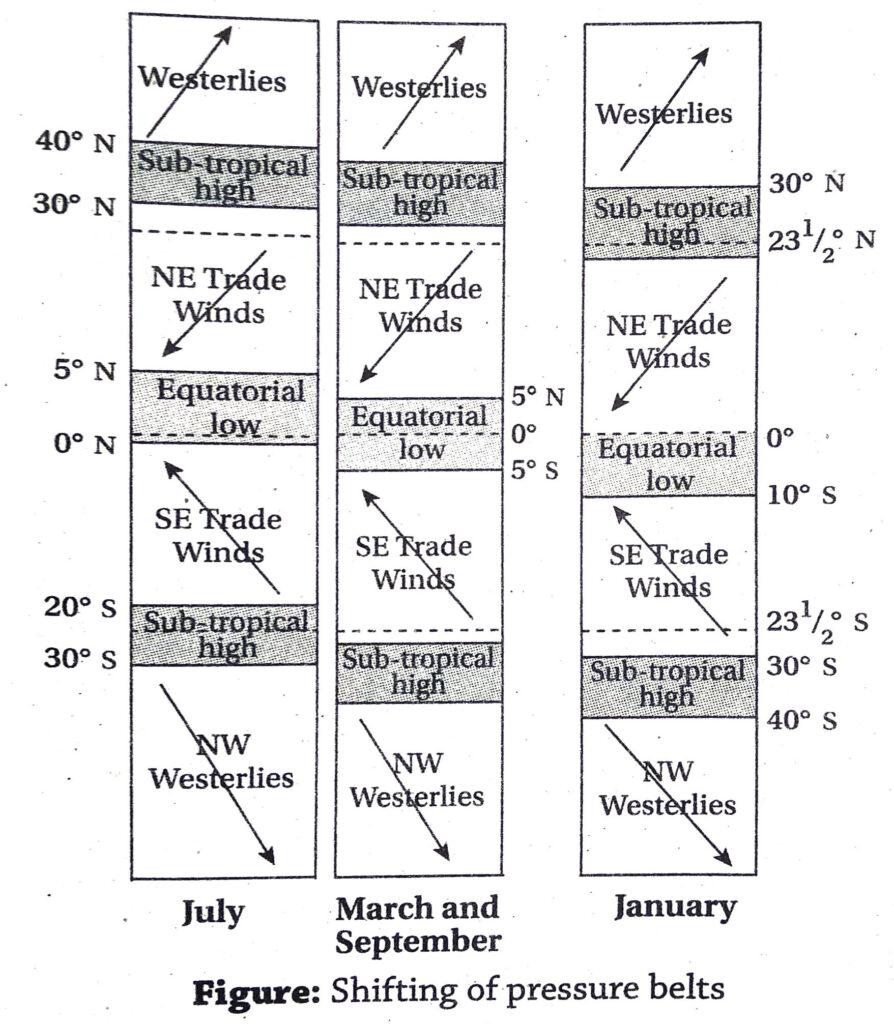
Ans. The earth is surrounded by three low pressure and four high pressure belts permanently. These pressure belts give rise to the planetary winds that blow in a fixed direction from high pressure belts towards low pressure belts throughout the year.
The planetary winds are of three types-1. Trade winds, 2. Westerly winds and 3. Polar winds.

- Trade winds: The winds that blow from the sub-tropical high pressure belts in either hemisphere towards the equatorial low pressure belt throughout the year, are called trade winds. Trade winds are of two types- (1) North-east trade winds: These winds blow from the sub-tropical high pressure belt of the northern hemisphere near the Tropic of Cancer, towards the equatorial low pressure belt. The winds are deflected to the right according to Ferrel’s law. Thus, they blow from the north-eastern direction. (2) South-east trade winds: These winds blow from the sub-tropical high pressure belt of the southern hemisphere near the Tropic of Capricorn, towards the equatorial low pressure belt. The winds are deflected towards the left according to Ferrel’s law, and thus they blow from the south-eastern direction.
Characteristics : [i] The speed of trade winds is slower in the northern hemisphere (15-25 km/hr) due to the presence of more landmasses. [ii] The speed of these winds is greater in the southern hemisphere (25-35 km/hr) due to the presence of more water bodies. [iii] The winds blow between 0 and 30° N and S latitudes throughout the year. [iv] A number of deserts have been formed in the path of the trade winds. Example-Sahara, Thar, Kalahari, Atacama, etc.
- Westerly winds: The winds blowing from the sub-tropical high pressure belts towards the sub-polar low pressure belts in both the northern and southern hemispheres throughout the year are called westerly winds, or westerlies. The westerlies are of two types- (1) South-west westerlies: The winds blowing from the sub-tropical high pressure belt near the Tropic of Cancer towards the sub-polar low pressure belt near the Arctic Circle in the northern hemisphere throughout the year, are called south-west westerlies. According to Ferrel’s law, they are deflected towards the right. (2) North-west westerlies: The winds blowing from the sub-tropical high pressure belt near the Tropic of Capricorn towards the sub-polar low pressure belt near the Antarctic Circle in the southern hemisphere throughout the year, are called north-west westerlies. According to the Ferrel’s law, these winds are deflected towards the left.
Characteristics: [i] The winds are named as westerlies as they blow from the west. [ii] They blow between 30° and 60°N and S latitudes in both the hemispheres. [iii] The westerlies cause more rainfall on the western margins of the continents than the east. [iv] Less rainfall on the eastern margins of the continents have led to the formation of vast grasslands in the temperate region. E.g.-Prairies in North America, Pampas in South America, Steppe in Russia and Europe, Downs in Australia and Veld in South Africa.
- Polar winds: The winds that blow from the high pressure belts around the poles towards the sub-polar low pressure belts in both the hemispheres are called polar winds. The polar winds are of two types- (1) North-east polar winds: The winds that blow from the polar high pressure belt around the North Pole towards the sub-polar low pressure belt near the Arctic in the northern hemisphere are called north-east polar winds. They are deflected towards the right according to Ferrel’s law. (2) South-east polar winds: The winds that blow from the high pressure belt around the South Pole towards the sub-polar low pressure belt near the Antarctic Circle in the southern hemisphere are called south-east polar winds. They are deflected towards the left according to Ferrel’s law.
Characteristics: [i] Polar winds are extremely cold and dry. [ii] The influence of these winds is more actively felt during the winter. [iii] Polar winds cause snowfall and a little rainfall on the eastern margins of the continents. They cause severe blizzards near the Arctic and Antarctic Circles.
6. Describe the various periodic winds.
Ans. Periodic winds: The winds that blow regularly for a certain period of time over a certain region due to differences in pressure conditions are called periodic winds. Periodic winds are of three types-1. Sea breeze, 2. Land breeze and 3. Seasonal winds.
- Sea breeze: In the coastal regions during
daytime, the land gets heated faster than the sea. Thus, the air adjacent to the land also gets heated, expands, becomes light and tends to rise upwards. This creates a vacuum on the land, leading to low pressure conditions. The air over the sea is comparatively cooler and denser. Hence, a high pressure condition prevails over the sea. Winds rush from this high pressure region towards the low pressure region on the land. This is known as sea breeze.
- Land breeze: In the coastal regions during night, the land radiates the heat very fast and cools down. The sea remains warmer, and the air over the sea also becomes warmer, lighter and tends to rise upwards. Thus, low pressure conditions are created over the sea. The land being comparatively cooler, the air adjacent to it is cool and heavy. This air rushes towards the low pressure region over the land. This is known as land breeze.
- Seasonal winds: Seasonal winds are caused due to differential heating of the land and water bodies in different seasons. During summers, low pressure cells are created over the land surface, which draw winds from the sea. During winter, high pressure conditions are created over land, from where winds blow towards the sea. In India, the periodic seasonal winds are known as monsoon winds. The south-west monsoon winds blow during summer and the north-east monsoon winds blow during winter.
7. Discuss about the occasional winds.
OR, What are cyclones and anticyclones? Discuss about them briefly.
Ans. Occasional winds: The winds that occur suddenly due to sudden differences caused in the atmospheric pressure conditions, are called occasional winds. There is no regularity of their occurrence. They may last for few hours or few days.
They are classified into two types-1. Cyclones and 2. Anticyclones.
- Cyclones: If a low pressure cell is created suddenly due to some reasons, the cool and heavy winds around the low pressure cell rush in to balance the pressure conditions in circular motions with great speed. These are called cyclones.
Direction of winds: The cyclones blow in the anti-clockwise direction in the northern hemisphere and in the clockwise direction in the southern hemisphere.
Classification: Cyclones can be classified into two types-
(1) Tropical cyclones: In both the northern and southern hemispheres, especially between 1616° and 24° latitudes, the temperatures over the sea may rise so much during summers that the adjacent air masses get hot, become lighter, expand and tend to rise upwards. This creates a deep low pressure cell. Cooler and heavier winds from the surrounding regions rush with high speeds towards this centre of low pressure in circular motions. These are called tropical cyclones. The cyclones are known by different names in different countries. E.g.-Typhoon in East and South China sea; Hurricane in the Caribbean sea; Tornado or Twister in central USA.
(2) Temperate cyclones: In northern and southern hemispheres between 35° and 65° latitudes, two contrasting air masses of different physical properties meet with each other. The line along which warm sub-tropical air mass and cold polar air mass meet with each other is called a front. The cold air tends to move downwards and the warm air tries move upwards. As the warm air enters the cold air, it gains speed and rises upwards in a circular motion. In this way a temperate cyclone forms.
- Anticyclones: In the temperate and frigid zones in both northern and southern hemispheres, sometimes a high pressure cell is created due to severe cold and concentration of air. Cold and dry winds blow out from the high pressure cell towards the surrounding low pressure regions in circular motions. These are called anticyclones. In the northern hemisphere, the anticyclones move in the clockwise direction and in the southern hemisphere it moves in the anticlockwise direction. The winds move from the centre outwards and descend downwards.
8. What are planetary winds? Describe the trade winds.
Ans. Planetary winds: The winds blowing from the high pressure belts towards the low pressure belts earth throughout the year in a fixed direction, are called planetary winds. There are three kinds of planetary winds-1. Trade winds, 2. Westerly winds and 3. Polar winds.
- Trade winds: The planetary winds blowing from the sub-tropical high pressure belt towards the equatorial low pressure belt in both the hemispheres are called the trade winds. These winds blow from the eastern direction, and hence are also called easterly winds or easterlies. In early times, these winds helped the ships to sail in the tropical regions for trade and business. Thus, they were named as ‘Trade winds’.
Classification: Trade winds can be classified into two types-
(1) North-east trade winds: These winds blow from the sub-tropical high pressure belt near the Tropic and Cancer in the northern hemisphere towards the equatorial low pressure belt. The winds are deflected towards the right according to the Ferrel’s Law, and blow from the north-east.
(2) South-east trade winds: These winds blow from the subtropical high pressure belt near the Tropic of Capricorn in the southern hemisphere towards the equatorial low pressure belt. The winds are deflected towards the left according to Ferrel’s Law, and blow from the south-east.
Characteristics: [i] The speed of the trade winds is less in the northern hemisphere due to the presence of more landmasses (15-25 km/hr). [ii] In the southern hemisphere, the speed of the trade winds is more (25-35 km/hr) due to presence of more water bodies. [iii] The trade winds blow between 0° and 30° latitudes in both northern and southern hemispheres. [iv] The winds blow from the tropical to the equatorial region. Thus, the winds become warm and their moisture holding capacity increase.
Influence on climate: [i] In the northern hemisphere, the trade winds fail to provide enough rainfall. [ii] In the southern hemisphere, the winds gather moisture from the sea (due to evaporation) and cause rainfall. [iii] The trade winds cause rainfall along the eastern margin of the continents, and become dry as they move westwards. Thus, several hot deserts have been formed on the western side of the continents in the tropical region. E.g.- Sahara, Kalahari, Thar, Atacama, etc.
9. What are local winds? Describe same of them.
Ans. Local winds: The winds that are generated over a region due to local geographical and environmental factors that create a difference in temperature and pressure conditions of the atmosphere, are called local winds. The local winds are broadly classified as hot winds and cold winds.

- Loo: In India, during summer, the north-western region becomes too hot in the daytime. The air adjacent to this region also get heated and starts blowing parallel to the earth’s surface with great speed. This very hot and dry wind is called Loo. Loo commonly blows over Delhi, Rajasthan, western Uttar Pradesh, etc. The velocity of the wind decreases during the evening. The wind is so hot that the heat often kills people and cattle.
- Foehn: The Foehn blows along the northern slopes of the Alps mountains in Europe and enters in the valley of the river Rhine. Warm and dry air follows the down-slope of the Alps mountains and starts descending with speed. The temperature of the wind increases with the downward movement. This warm, dry wind is known as Foehn. This wind can raise temperatures by as much as 15°C in just a matter of minutes and cause the snow to melt. The snow melt water helps in growth of vast grasslands in the valleys of the Alps mountains.
- Chinook: In North America, the warm and dry wind descending along the eastern slopes of the Rocky mountains is known as Chinook. ‘Chinook’ means snow-eater. This warm and dry wind melts the snow lying in the foothill regions of the Prairies in winter.
- Sirocco and Khamsin: In Africa, during the summer, very hot, dry, dusty winds generate over the Sahara desert and blow towards the Mediterranean Sea in the north. Such winds are called Sirocco in Sicily and Khamsin in Egypt.
- Nor’westers: This is a hot, humid local wind blowing over the eastern India (Jharkhand, Odisha, Bihar, West Bengal and Assam) and Bangladesh during the summer season in the months of April-May. The wind generates from the Chotanagpur plateau region of Jharkhand. It causes thunder storms, lightning and little rainfall.
- Aandhi: In the plains of north-western India, a hot dry dusty storm blows during the summer due to sudden pressure changes caused by extreme heating. This dust storm is known as ‘aandhi’. The wind may blow at a speed of 70-100 km/hr and reduces visibility due to huge amount of dust present in the air.
- Mistral: This is a cold local wind. This wind generates in the Alps and blows over the valley of river Rhone in France. This wind causes the temperature of the Rhone valley to drop considerably.
- Pampero: The cold dry wind blowing over the Pampas grasslands from the Andes mountains in south America, is called Pampero.
- Bora: In Europe, during the winter, a cold dry wind blows from the Alps mountains towards the Adriatic sea coast. This is known as Bora. This wind decreases the temperature of the Adriatic coast considerably.
Short Explanatory Answer Type Questions
1. What do you understand by high pressure and low pressure of air?
Ans. Air has mass, and hence pressure. The pressure of air depends upon the density of the air molecules present in the region.
High pressure: If a huge number of gas molecules concentrate in a certain place, they exert pressure. Thus, conditions of high pressure prevail.
Low pressure: If a very little number of gas molecules concentrate in a certain place, they exert very less pressure, as mass is negligible. Thus, low pressure conditions prevail.
The pressure of the atmosphere is measured by different types of barometers. If the recorded air pressure is more than 1013 mb, conditions of high pressure prevails. If the recorded air pressure is less than 986 mb, the conditions of low pressure prevail.
2. What are horse latitudes?
Ans. In both the northern and southern hemispheres, at 30°-35°C latitudes, high pressure prevails due to sinking of heavy and cold air over this region. Hence, there is no movement of wind felt in this region, and a calm condition prevails.
Horse latitude: In early days, the ships that used to sail from Europe to North America and West Indian islands with horses, used to loose their speed while crossing this calm region. Then, the sailors used to throw away some horses into the sea in order to reduce weight and consumption of food and water. This helped the ships to sail forward with the help of whatever little wind blowing. Due to this incident, the sub-tropical calm region between 30° and 35° latitudes came to be known as horse latitudes.
3. What are pressure belts? How many pressure belts can be seen in the atmosphere?
Ans. Pressure belts: In certain regions of the earth’s surface, conditions of high pressure or low pressure are found persistently throughout the year surrounding the earth like large belts. These are known as pressure belts.
Different pressure belts: On the earth surface, there are seven pressure belts. They are-1. Equatorial low pressure belt, 2. Sub-tropical high pressure belt in the northern hemisphere 3. Sub-tropical high pressure belt in the southern hemisphere, 4. Sub-polar low pressure belt in the northern hemisphere, 5. Sub-polar low pressure belt in the southern hemisphere, 6. Polar high pressure belt in the northern hemisphere) and 7. Polar high pressure belt in the southern hemisphere.
4. What are the causes of formation of hot deserts in tropical and sub-tropical regions?
Ans. Location: Hot deserts have been formed in the tropical and sub-tropical regions. Eg- Sahara and Kalahari in Africa, Atacama in South America, Thar in India-Pakistan, Sonoran in North America, the Arabian desert in Arabian peninsula, etc.
Causes: The tropical and sub-tropical belts are regions of high pressure. As the air moves downwards, it becomes warmer and its moisture holding capacity increases. Thus, instead of causing rainfall, it acquires more water vapour. Thus, lack of rainfall or very little rainfall have led to the formation of hot deserts in the tropical and subtropical regions.
5. What is the relation between temperature and pressure of air?
Ans. The relation between temperature and pressure of air is inverse, i.e., pressure decreases with increase in temperature and vice versa.
Causes: 1. When air is heated, it expands in volume. Thus, density reduces which results in reduction of pressure. 2. When air is cooled, it contracts in volume. Thus, density increases, which results in increase in pressure.
6. Why do the pressure belts shift at certain times of the year?
Ans. On the earth surface there are three low pressure belts and four high pressure belts. These belts are generally fixed in their locations, but at certain times of the year they seem to deviate for a few degrees northwards and southwards. This is known as shifting of pressure belts.
Causes: Due to the revolution of the earth, the sun apparently moves northwards and southwards. Thus, the thermal equator or the heat equator also shifts accordingly. When it is summer in the northern hemisphere, the
thermal equator and all the pressure belts move 5°-10° towards the north. During winter in the northern hemisphere, the thermal equator as well as well as all the pressure belts move 5°-10° towards the south. Generally, the shifting of pressure belts is more prominent in the lower latitudes than the higher latitudes.
7. What are the effects of the shifting of pressure belts?
Ans. The pressure belts move 5°-10° northwards and southwards according to the. apparent movement of the sun towards the northern and southern hemispheres. This is known as the shifting of pressure belts.
Effects: 1. The direction of planetary winds change at regions when the pressure belts are seen to shift. 2. The rainfall belts also shift along with the wind and pressure belts. Example- During summer, when the trade winds shift northwards, the Savannah region receives rainfall. 3. During winter, due to the southward movement of the pressure belts, the Mediterranean region come under the influence of westerly winds which cause rainfall. But the summers are dry here.
8. What is the relation of air pressure and wind movement?
Ans. Winds are created due to differences in air pressure between adjacent areas. The wind speed depends upon the level of the difference in pressure conditions. If the pressure gradient is steep, i.e., there is a large difference in pressure conditions of two adjacent places, the winds blow from the high pressure region to the low pressure region with great speed. But, if the pressure gradient is gentle, i.e., difference in pressure conditions of two adjacent places is small, winds blow from the high pressure region towards the low pressure region with gentle speed.
9. Why is moist air lighter than dry air?
Ans. A fixed volume of gas at constant pressure and temperature will have the same number of molecules. Dry air mostly consists of nitrogen and oxygen molecules. However, when this air becomes moist, few of these nitrogen and oxygen molecules are replaced with water molecules (to maintain the equal number of molecules in the given volume of gas). Water molecules by nature are lighter in weight than either of the oxygen and nitrogen molecules. Thus, moist air becomes lighter than dry air.
10. What are periodic winds? Classify periodic winds and write about any one of them.
Ans. The winds that blow over certain places at definite times of a day or season for a definite duration are called periodic winds. The winds are generated due to the difference in pressure conditions between land and sea. Such winds can be classified into three types-1. Sea breeze, 2. Land breeze and 3. Monsoon winds.
- Sea breeze: The winds blowing from over the sea towards the land in coastal regions during the daytime is called sea breeze.
- Causes: During daytime in coastal areas, the land gets heated up more than the sea when exposed to the same amount and same duration of sunlight. Thus, the air adjacent to the land becomes more warmer than the air adjacent to the sea. The warmer air over the land becomes lighter. and tends to rise upwards, thus creating a temporary vacuum. Cooler air over the sea tends to rush in and fill up the vacuum and balance the difference in pressure.
- Time: Sea breeze blows throughout the day, but it is strongest during the afternoon, when the difference in pressure conditions over land and water is the maximum.
- Effect: The cooler winds coming from the sea reduce the temperature of the land and the moisture present in it may cause rainfall. Thus, the coastal areas enjoy a very pleasant climate.
11. Why do westerly winds cause rainfall in the western parts of the continents in winter?
Ans. The westerly winds blow between 35° and 60° latitudes in both the northern and southern hemispheres. During winters, the sea remains warmer than the land. Air blowing over the sea thus absorbs heat and becomes warm and collects moisture. The westerly winds come in contact with the cold polar winds and the moisture starts condensing. As the winds enter the continents from western sides, they cause rainfall in the western margins which gradually go on decreasing towards the east.
12. Why do winds blow?
Ans. Winds blow because of the following reasons-
- Difference in pressure: Winds blow from high pressure regions to low pressure regions. Hence, greater the difference in pressure, greater is the wind speed.
- Difference in temperature: Air tends to get heated fast if the earth’s surface is heated. The warm air thus, becomes light, expands and rises upward. Thus, a temporary vacuum is created at the surface levels. Cooler winds that are heavier, rush towards this vacuum to fill it up and balance the pressure conditions. Thus, winds blow.
- Amount of water vapour: Pressure of water vapour in the air makes the air light. This causes low pressure conditions. Hence, winds from adjacent high pressure regions rush in to fill up and balance the low pressure conditions.
- Rotation of the earth: The Coriolis force created due to the rotation of the earth does not allow winds to blow in the straight direction. The winds are deflected towards the right in the northern hemisphere and towards the left in the southern hemisphere.
13. How can weather forecasts be given with the help of a barometer?
Ans. Weather forecasts can be given with the help of a barometer in the following ways-1. If the mercury level in the barometer suddenly drops, it is understood that air pressure has been reduced, and a low pressure has formed. 2. If the mercury level drops further, it indicates formation of a deep low pressure cell. Speedy winds gushing in from adjacent high pressure regions may cause storms with thunder, lightning and rainfall. 3. If the mercury level remains high, it indicates high pressure conditions. Weather remains calm and the sky remains clear during such conditions.
14. What are anticyclones?
Ans. In the temperate and frigid zones, if a high pressure cell is created due to excessive cold condition, the winds tend to blow outward from the high pressure cell with great speed in circular motions. This is known as anticyclone. Anticyclones are the opposite conditions of cyclones. These winds blow outward from the centre and move downward, as the winds are cold and heavy.
Characteristics: 1. High pressure conditions prevail in the centre of anticyclones. 2. The winds always blow away from the centre. 3. The winds are cold and move downwards. 4. In the northern hemisphere the winds move in the clockwise direction. In the southern hemisphere they blow in the anticlockwise direction. 5. Sky remains clear in anticyclones.
15. What is a jet stream? What are its characteristics?
Ans. The high speed winds blowing in a thin band through the upper Troposphere is called the jet stream.
Characteristics: 1. The winds blow in the same direction as the isobars through the upper atmosphere. Thus, it is a geostrophic wind. 2. The jet stream is very strong and speedy. The average speed varies between 100 and 500 km. 3. The winds blow like a thin band or stream, hence the name jet stream. 4. Jet streams blow between 30° and 60° latitudes in both the hemispheres. The position of jet stream changes with the northward and southward apparent movement of the sun.
16. What are the different types of jet stream?
Ans. Jet streams are of three types-
- Polar jet stream: The jet stream that originates at the meeting point of the tropical warm air mass and polar cold air mass, is known as the Polar jet stream. This jet stream blows between 45°N and 60°N latitudes in the upper Troposphere from the west to the east.
- Subtropical jet stream: The jet stream blowing between 25° and 30° latitudes in both the hemispheres in the sub-tropical region, is called the Subtropical jet stream. This is much weaker than the polar jet stream.
- Tropical jet stream: In the northern hemisphere, during summer, a jet stream blows over Africa and south-east Asia through the upper atmosphere from the east towards the west. This is called the Tropical jet stream or the easterly jet stream. It is a weak jet and blows mainly during summers. It plays a major role in the Indian monsoon mechanism.
17. List the importance of jet streams.
Ans. Although the jet streams blow through the upper atmosphere, they have important effects on the lower atmosphere, such as-
- Jet streams cause cyclones in the temperate zones.
- The onset and retreat of south-west monsoon winds depend on the jet streams.
- Aeroplanes can save time and fuel if they can follow the direction of the jet streams.
- The jet streams influence the flow of winds and amount of rainfall of a region.
18. What are the components of weather and climate?
Ans. The components which make up the weather and climate of a region are known as components of weather and climate. They are- 1. Temperature, 2. Air pressure, 3. Wind direction, 4. Wind speed, 5. Humidity, 6. Cloud Cover, 7. Rainfall, 8. Snowfall, etc.
The combination of these components gives rise to different weather conditions. The average weather conditions recorded for the last 35 years in a place in known as the climate.
19. How does difference in air pressure generate winds?
Ans. Winds are generated primarily due to difference in pressure conditions between two regions. If the ground gets heated too much, the adjacent air also gets heated. This air becomes lighter and tends to rise upward. Thus, a vacuum or low pressure cell is created. Winds from the adjacent cooler regions rush towards this low pressure region and try to bring a balance in the pressure conditions. Thus, winds blow from high pressure regions to low pressure regions.
20. List the characteristics of tropical cyclones.
Ans. The characteristics of tropical cyclones are-
- The centre of the cyclone, where the pressure remains the lowest is called the eye of the cyclone.
- Generally clear sky and calm conditions prevail in the eye region of the cyclone.
- The eye of the cyclone is surrounded by cumulonimbus clouds.
- Winds rush in from the region around the eye with great speed and cause thunderstorms and rainfall.
- The cyclones move in the anticlockwise direction in the northern hemisphere and clockwise direction in the southern hemisphere.
21. Write a short account on the ‘nor’westers’.
Ans. Nor’westers or Kalbaishakhi is a tropical storm which occurs in India and Bangladesh. In India, the states of West Bengal, Odisha, Bihar, Jharkhand and Assam come under the influence of nor’westers in the summer season. This is a sudden wind that causes thunderstorms, rainfall, and sometimes hailstorms.
Causes: During the summer season, the day-long heating of the Chotanagpur plateau heats up the adjacent air. Thus, warm air rises upwards and creates a low pressure cell over the rocky plateau region. This low pressure cell is the main cause of drawing winds from the surroundings and forming a tropical storm. Usually, the air comes from the north-western direction to fill up the low pressure region, hence the name ‘nor’westers’ (north + western).
Effects: The day’s temperature may fall up to 10° C with little rainfall. However, the rainfall is beneficial for tea, rice and jute cultivation.
Short Answer Type Questions
1. How are high and low pressure of airdetermined?
Ans. The normal air pressure at mean sea level is 986 mb to 1013 mb. If air pressure is recorded less than 986 mb, it is said to be low pressure. If air pressure recorded is greater than 1013 mb, it is said to be high pressure.
2. How is the speed of wind determined?
OR, What is an anemometer?
Ans. The wind speed is recorded by an instrument known as anemometer. Anemometer has graduated dial fixed at its head. When wind blows the bowls move like the wheel of a turbine. The speed at which the pole rotates along with the bowls is recorded by the graduated dial at the base of the instrument.
3. Name the instruments measuring air pressure.
Ans. Air pressure is measured with the help of Torricelli’s barometer, Fortin’s barometer, Aneroid barometer, Barograph and other modern instruments.
4. What is jet stream?
Ans. The thin stream of air blowing through the upper atmosphere from the west to the east at a very high speed (110-500 km/hr) is known as the jet stream. The tropical and sub-tropical jet streams influence the climate of India.
5. What are trade winds?
Ans. The planetary winds that blow from the subtropical high pressure zones in the northern and southern hemispheres towards the equatorial low pressure zone in particular direction throughout the year, are called trade winds. They are basically easterly winds, i.e., they blow from the north-east to the south-west in the northern hemisphere and from the south-east to the north-west in the southern hemisphere. In early days, these winds helped in trading ab across the oceans by sailing ships. Hence, they are called the trade winds.
6. What are anti-trade winds?
Ans. The planetary winds that blow in the opposite direction of trade winds are called abr anti-trade winds. In both the northern and southern hemispheres, the winds blow $10 towards sub-polar low pressure zone near the Arctic and Antarctic circles from the high pressure zone near the tropics. The direction of wind in the northern hemisphere is from south-west to north-east, and that in the southern hemisphere is from north-west to south-east. Thus, these winds are also known as westerly winds.
7. Why are the westerlies more speedy in the southern hemisphere?
Ans. The amount of landmass is greater in the northern hemisphere than the southern hemisphere. Thus wind gets obstructed in thenorthern hemisphere by the land and slows down due to friction. On the other hand, winds blow unhindered in the southern hemisphere over the oceans. bol Thus, wind speed is greater in the southern hemisphere than the northern hemisphere.
8. What are roaring forties?
Ans. In the southern hemisphere, presence of landmarks is very less beyond the 40°S latitude. Thus, the westerly winds blow with extreme speed over the oceans due to very less friction with water. These winds make much noise while blowing. Hence, the latitude adjacent to the 40°S latitude is referred to as roaring forties.
9. What are planetary winds?
Ans. The winds that blow over the earth throughout the year from a fixed direction without much fluctuation, are called planetary winds. They can be classified into three types- 1. Trade winds, 2. Westerlies and 3. Polar winds. The planetary winds develop due to the rotation of the earth and the existence of the pressure belts around the earth.
10. What do you mean by monsoon winds?
Ans. Monsoon winds are periodic winds generated in certain places due to difference in temperature and pressure conditions on land and water in different seasons of the year.
Monsoon winds blow from opposite direction in different seasons of the year. If the south-west monsoon blows over the Indian subcontinent from the south-west direction during summer. It blows from the reverse direction as the north-east monsoon wind during winter.
11. Why are monsoon winds called seasonal winds?
Ans. ‘Monsoon’ comes from the Arabic word ‘Mousam’ meaning seasons. The winds blow from the south-west direction in the summer season and from the north-east direction in the winter. As the characteristics of the winds change in different seasons, the winds are also called seasonal winds?
12. What is a cyclone?
Ans. Cyclone is a sudden wind developed due to sudden difference in pressure conditions in a region. If a low pressure cell is created at any point due to excessive heating, winds from the adjacent high pressure regions gush towards the low pressure cell in circular motions with great speed. Cyclones can be highly devastating and may last from a few hours to few days. They may cause heavy rainfall if they are generated near coastal areas.
Cyclones can be classified into two types- 1. Tropical cyclones and 2. Temperate cyclones.
13. What do you mean by the eye of a cyclone?
Ans. The low pressure cell at the centre of a tropical cyclone is known as the eye of the cyclone. It can extend from 20-40 km in diameter. The weather conditions in the eye remain calm and cloudless even though severe storms and rainfall may occur in other parts of the cyclone.
14. What is ‘Chinook’?
Ans. The ‘Chinook’ is a local wind blowing from the eastern slopes of the Rocky mountains in North America towards the Prairie region at the foothills of the mountains. These are hot and dry winds that cause the snow of the Prairie region to melt. The word ‘Chinook’ means ‘snow eater’. As this wind melts all the show, it has been so named. The snow melt water moisten the soil of the Prairie region and help in the growth of vast grasslands.
15. What is ‘Foehn’?
Ans. ‘Foehn’ is a local wind blowing from the Alps mountainous region towards the Rhine valley in Europe.
Effects: 1. The hot and dry wind rises along the slope of the Alps mountains and starts cooling down. The water vapour present in the air condenses and causes rainfall and snowfall. 2. As the wind crosses the Alps mountains and moves down-slope towards the Rhine valley, it starts expanding. Thus, it becomes warm and dry.
16. What is Sirocco?
Ans. The hot, dry, dusty wind blowing locally over the Sahara desert is called Sirocco.
Effects: 1. The hot dry wind become humid as it moves towards the north-east and crosses the Mediterranean sea. 2. The Sirocco is harmful for the cultivation of olives in Italy and Sicily.
17. What is ‘Loo’?
Ans. The hot dry local wind blowing in north-western India is called ‘Loo’. During summer, the land surface in north-western India get extremely heated. The air adjacent to this land also gets heated by radiation of this heat. During the afternoon, this heated air blows as very speedy wind parallel to the earth’s surface. The local people call this hot wind ‘Loo’.
18. What is ‘Aandhi’?
Ans. The Aandhi is a violent, squally dust storm occurring in summer season in north- western states of India over Uttar Pradesh, Rajasthan and Punjab. The wind blows at a very high speed, about 70-100 km per hour. The dust particles blown up by the wind reduce visibility to almost zero and makes the surrounding dark. Hence, it is named ‘Aandhi’ meaning darkness.
Effects: 1. These dust storms may cause very little rainfall. 2. Aandhi helps to reduce the air temperature and the weather feels pleasant after the storms stop blowing.
19. What is a hurricane?
Ans. The strong tropical cyclone that develops over the Caribbean sea and the islands of West Indies is called a hurricane. The hurricane may have a diameter of 650 km and blow at an average speed of more than 140 km/hr. The eye of the hurricane consists of a very deep low pressure cell.
20. What is a tornado?
Ans. A violently rotating column of air extending from the base of a thunder storm to the ground is called a tornado. Tornadoes are often associated with funnel shaped clouds. In USA, the tornadoes are also known as twisters.
Characteristics: 1. The speed of these storms may reach up to 500 km/hr. 2. The centre of the tornado may be 100-500 m in diameter. 3. A number of tornadoes generating close to each other over a region are considered as the tornado family.
21. What is Mistral wind?
Ans. The strong, cold dry north-westerly wind blowing from the Alps mountain region to the Rhone valley in France in Europe, is known as Mistral wind. The Mistral wind can reach velocities of 130 km per hour.
22. What is Bora wind?
Ans. The very strong cold wind blowing over northern Italy and the eastern coast of the Adriatic sea in Europe during the winter, is known as Bora. These winds often reach a speed above 120 km/hour and create cloudless skies and cold weather conditions.
23. What do you mean by weather and climate?
Ans. Weather: 1. The condition of temperature, air pressure, humidity, cloudiness, rainfall, snowfall, etc. of a certain place at a certain time is known as weather. Weather may persist for few moments, few hours or few days.
Climate: The average weather conditions persisting over an area for at least 35 years is known as the climate. In other words, climate is the average of weather conditions over a long period of time.
24. Why are easterly winds also called Trade winds?
Ans. In earlier days, the ships used to sail across the oceans in the direction of the easterly winds for trade and commerce between the countries lying in the tropical region. As the winds helped in trade by helping the ships to move faster along the direction of the winds, they came to be known as Trade winds.
25. What are anticyclones?
Ans. Anticyclones are the opposite conditions of the cyclones. In the Temperate and Frigid zones, over a small area of land, air may suddenly get cold and heavy and start moving downwards. This creates a deep high pressure cell over the area. In such a condition, the winds start gushing out of the high pressure region towards the adjacent low pressure regions in circular motions. This is known as anticyclone. Anticyclones rotate in clockwise direction in the northern hemisphere and anticlockwise direction in the southern hemisphere.
26. What are mountain breeze and valley breeze?
Ans. Mountain breeze: In the mountainous regions during the night, air cools down and becomes heavy due to radiation of heat, and slips downwards along the slope. This causes the warm air to stay above the cold air. These breezes or winds are known as katabatic winds.
Valley breeze: In mountainous regions during daytime, air starts getting heated, becomes lighter and tends to rise along the slopes of the mountain valleys and yield precipitation on reaching greater heights. These are known as anabatic winds or valley breezes or winds. Valley breezes cause formation of clouds on the upper parts of the mountains.
27. What is the Buys Ballot’s Law?
Ans. The Buys Ballot’s Law was proposed by the eminent scientist Buys Ballot during the 19th century. According to the law, if one stands with his back facing the wind direction in the northern hemisphere, air pressure felt on the left side is less than the pressure on the right side. The reverse condition is experienced in the southern hemisphere.
28. What are water column and sand column?
Ans. Water column: When a severe storm passes over an ocean, the cyclonic winds attract the ocean water and pull it upwards. Thus, the water rises like a pillar over the ocean. This is known as the water column.
Sand column: When a cyclone blows over a desert region, it may attract the sand particles from the desert surface and draw them upwards, thus forming a big pillar of sand. This is known as the sand pillar.
29. What are periodic winds? Give examples.
Ans. The winds generated over the earth in the atmosphere at certain fixed times of the year are called periodic winds. Examples- Land breeze, sea breeze, monsoon winds, etc.
30. What is Sea breeze?
Ans. Sea breeze is an example of periodic winds. In coastal regions during the daytime, the land gets heated and causes the air to get heated accordingly. This warm air becomes lighter and rises upward, thus creating a partial vacuum over land. The cool winds from the sea rush towards the land to fill up this vacuum. This is known as ‘Sea breeze’. The maximum speed of the sea breeze occurs during the afternoon when the difference in temperature between land and sea is at its highest. [Winds blow from the sea to land.]
31. What is land breeze?
Ans. Land breeze is an example of periodic winds in coastal regions. At night, the sea is more warmer than the land. Thus, air over the sea becomes more warmer than the land. This warm air becomes lighter and rises upwards, creating a vacuum over the sea. Cool winds from the land then rush towards the sea to fill up the partial vacuum. This is known as land breeze. The maximum speed of the land breeze occurs in the early morning [Winds blow from the land to the sea].
32. What are geostrophic winds?
Ans. The thin streams of wind generating in the upper part of the atmosphere at 6-8 km altitude, parallel to the isobars are called geostrophic winds. Such winds are produced when the pressure gradient force and Coriolis force come into balance and the condition is called geostrophic balance.
Multiple Choice Type Questions [MCQ type]
Write the correct answer from the given alternatives
1. Air pressure at sea level is-
A. 1013.2 mb
B. 1013.5 mb
C. 1013.8 mb
D. 1013.9 mb
Ans. A
2. There are ………. pressure belts on the surface of the earth.
A. Three
B. Four
C. Five
D. Seven
Ans. D
3. The imaginary line joining places having same temperature conditions is called-
A. Contour
B. Isotherm
C. Isobar
D. Isohyte
Ans. B
4. The horse latitudes are located in both the hemispheres between-
A. 25° and 30°
B. 30° and 35°
C. 35° and 40°
D. 40° and 45°
Ans. B
5. ………. persists in the Arctic and Antarctic Circles-
A. High pressure
B. Low pressure
C. No air pressure
D. Medium air pressure
Ans. B
6. Air pressure is measured by the –
A. Barometer
B. Thermometer
C. Hygrometer
D. Calorimeter
Ans. A
7. The pressure of moist air is ……… than dry air-
A. Less
B. More
C. Same
D. Medium
Ans. A
8. The wind remains …….. at the high pressure belt of the sub-tropical region-
A. Turbulent
B. Calm
C. Moderate
D. Upwards
Ans. B
9. The instrument that is used in aeroplanes to measure air pressure is called-
A. Aneroid Barometer
B. Fortin’s Barometer
C. Barograph
D. Barometer
Ans. C
10. Air pressure at the equator is-
A. Low
B. High
C. Moderate
D. Nil
Ans. A
11. If temperature increases air pressure-
A. Increases
B. Decreases
C. Remains same
D. None of these
Ans. B
12. Doldrums are created in the-
A. Equatorial region
B. Tropical region
C. Polar region
D. Sub-tropical region
Ans. A
13. The low pressure in the equatorial region occurs due to-
A. Rotation of the earth
B. High humidity
C. High temperature
D. Greater circumference of the earth
Ans. C
14. The high pressure belt near the Tropic of Cancer lies between-
A. 30° and 35°N
B. 30° and 35°S
C. 60° and 65°N
D. 60° and 65°S
Ans. A
15. Air pressure is measured in-
A. Millibar
B. Millimeter
C. Milligram
D. Degree Celsius
Ans. A
16. 1000 dyne/sq cm air pressure equal to-
A. 1 mb
B. 1 mm
C. 1 mg
D. 1 knot
Ans. A
17. A high pressure belt is formed in the-
A. Equatorial region
B. Arctic Circle region
C. Subtropical region
D. Antarctic Circle region
Ans. C
18. Which one is not a cause of wind movement?
A. Difference in air pressure
B. Difference in temperature
C. Rotation of the earth
D. Ferrel’s law
Ans. D
19. The extent of the pressure belts changes due to-
A. Rotation of the earth
B. Apparent movement of the sun
C. Difference in wind flow
D. Aphelion and perihelion positions of the earth
Ans. B
20. The Coriolis force is maximum at the-
A. Equator
B. Mid-latitudes
C. Tropics
D. Poles
Ans. D
21. The wind speed is measured in-
A. Beaufort scale
B. Richter scale
C. Thermometer scale
D. Mercalli scale
Ans. A
22. The easterly winds are also known as-
A. Periodic winds
B. Westerly winds
C. Polar winds
D. Trade winds
Ans. A
23. The large deserts have been formed in path of –
A. Western side of the trade winds
B. Polar winds
C. Westerly winds
D. Loo
Ans. A
Very Short Answer Type Questions
If the statement is true, write ‘T’ and if false, write ‘F’ against the following
1. Wind speed is less in higher altitudes.
Ans. F
2. Wind speed is measured in knots.
Ans. T
3. Westerlies are also known as anti-trade winds.
Ans. T
4. Trade winds blow between 35° and 60° latitudes.
Ans. F
5. The Westerlies blowing over 50°S latitude is known as Screeching Sixties.
Ans. F
6. Pampero winds blow over the Pampas grasslands from the Andes mountains.
Ans. T
7. The tropical cyclone generated near the islands of western India is known as Hurricane.
Ans. F
8. The tropical cyclone generating over the southern part of USA is called tornado.
Ans. T
9. The 10°S latitude is called the horse latitude due to highly speedy and noisy winds.
Ans. F
10. Air pressure is high in summer and low in winter.
Ans. F
11. Air temperature is inversely related to air pressure.
Ans. T
12. The rotation of the earth causes low pressure near the Arctic and Antarctic Circles.
Ans. T
13. The chance of storms increase if the isobars lie far from each other.
Ans. F
14. Air rises upwards in the doldrum region of the equator.
Ans. T
Fill in the blanks with suitable words
1. The calm region near the tropics is known as the ……….
Ans. Horse latitudes
2. If the isobars lie close to each other in a concentric pattern, ………. many occur.
Ans. Storms
3. Air pressure ……….. with decrease in temperature.
Ans. Increases
4. Wind speed ……… if the pressure gradient becomes steep.
Ans. Increases
5. The Sirocco winds are known as ………. in Spain.
Ans. Leveche
6. Coriolis force becomes ………. near the equator.
Ans. Zero
7. The ITCZ lies along the ………..
Ans. Equator
8. The coastal regions experience ……… climate.
Ans. Moderate/maritime
9. The easterlies are also known as ……… winds.
Ans. Trade
10. Typhoon originate in the ……… Sea.
Ans. South China
11. The polar winds have very less humidity, hence pressure is ………
Ans. High
12. The polar winds have very less humidity, hence pressure ……….
Ans. Aneroid barometer
13. The ……… is used to measure wind direction.
Ans. Wind vane
14. The first instrument invented for measuring air pressure is ………..
Ans. Torricelli’s
15. A ………. scale is attached with Fortin’s barometer along with the main scale.
Ans. Vernier
Answer in one or two words
1. What are the lines joining places having equal pressure conditions called?
Ans. Isobars.
2. Which latitudes are called horse latitudes?
Ans. 30°-35° latitudes in both northern and southern hemispheres.
3. What kind of pressure persists between 0° and 10° latitudes?
Ans. Low pressure.
4. What kind of air pressure is found at the poles?
Ans. High pressure.
5. What is the unit of measuring air pressure?
Ans. Millibar.
6. Who invented the barometer?
Ans. Torricelli.
7. When does the land breeze blow?
Ans. During night.
8. When does the sea breeze blow?
Ans. During daytime.
9. When does the south-west monsoon winds blow?
Ans. During summer.
10. In which direction are the winds deflected in the southern hemisphere?
Ans. Towards the left.
11. Which instrument measures wind direction?
Ans. Wind vane.
12. Where is wind speed greater on the earth?
Ans. Between 40°S and 60°S latitudes.
13. What kind of a wind is monsoon winds?
Ans. Periodic wind.
14. What kind of pressure condition is found to be associated with cold and dry winds?
Ans. High pressure.
15. Name the planetary wind.
Ans. Trade winds, Westerlies and Polar winds.
16. Name a sudden wind.
Ans. Cyclone.
17. Name a periodic wind.
Ans. Land breeze/Sea breeze/Monsoon winds.
18. Name a local wind of India.
Ans. Nor’westers/Loo.
19. Name a tropical cyclone.
Ans. Tornado.
20. When was the Ferrel’s Law invented?
Ans. 1855.
21. When was the Buys Ballot’s Law invented?
Ans. 1857.
22. What is the other name of the westerly winds?
Ans. Trade winds.
23. Where are most of the deserts of the earth found?
Ans. Tropical region.
24. Why are greater number of pressure cells developed in the northern hemisphere?
Ans. Due to presence of landmasses.
25. Name a modern instrument for measuring air pressure.
Ans. Barograph.
26. Why is it difficult to boil food on the mountains?
Ans. Due to low pressure conditions.
27. Which force is created due to rotation of the earth?
Ans. Coriolis force.
28. Where does the dry wind called Harmattan blow?
Ans. Guinea coast of western Africa.
29. When did people first come to know about the jet stream?
Ans. During the second world war.
30. Name a wind blowing during the winter.
Ans. Sub-tropical westerly jet stream.
TOPIC – 4
Humidity and Precipitation
Long Answer Type Questions
1. How does rainfall occur?
Ans. Rainfall occurs by the following processes-
- Air contains some amount of water vapour, which make the air light and it tends to rise.
- As the moist air rises upward, pressure decreases, and the air starts cooling down.
- Gradually, the air in the upper atmosphere starts getting saturated, as the moisture holding capacity of the air decreases with increase in altitude. When the temperature of the saturated air falls below the freezing point, the extra water vapour starts condensing on the dust particles, carbon and salt particles floating in the air, forming tiny droplets of water and ice crystals.
- The water droplets thus formed collide with each other and adhere to form bigger droplets. These bigger droplets become heavy and cannot float in the air any more. Thus, they fall as rainfall. If the temperature. in the lower layers is quite low, snowfall may occur instead of rainfall.
2. How is rainfall caused by temperate cyclones?
Ans. In temperate regions, two air masses of opposite characteristics meet each other along a front. The cold and dry air coming from the north-eastern side meet the warm moist air coming from the south-western side along a front. The warm air enters the cold air from below and the cold air enters the warm from top. The place where the warm air meets the cold air is known as the warm front. The place where the cold air hits the warm air from the back is known as the cold front.
Rainfall at warm front: The warm air rises upward through the cold air. In this process, the water vapour present in the warm air comes in contact with the cold air and condenses. This causes rainfall.
Rainfall at cold front: The cold air pushes the warm air upward from the back. Thus, the warm air rises up, cools down and the water vapour present in the warm air starts condensing. This causes heavy rainfall with thunder and lightening.
Regions: Rainfall from temperate cyclones occur in many places in Europe during the winter season.
3. How does rainfall occur from tropical cyclones?
Ans. Tropical cyclones occur between 5-20°N and S latitudes during summers. Excessive heating of the region causes development of low pressure cells on the land. Cool and heavy air from the adjacent areas gush with great speed towards the low pressure cell in circular motions. This air gradually rises upward in a circular motion and starts becoming cooler. The water vapour present in the air condenses. The centre or eye of the cyclone remains calm, but winds from the surrounding areas rush with such speed that they cause severe storms along with heavy rainfall.
Example: Cyclones originate in the Bay of Bengal when the eastern coastal regions of India get heated in the summer season and develop low pressure cells. This type of cyclone forms. when the warm and moist south-west monsoon winds meet with the hot dry winds on land. Such a weak cyclone may cause rainfall for a few days continuously.
4. Classify precipitation.
Ans. The warm and moist air tends to rise upward and the water vapour condenses to form tiny droplets of water or ice crystals. These crystals and droplets come close and adhere to each other, thus growing in size. When they grow quite big, they cannot float in the air, and thus fall on the earth’s surface due to gravitational force. This is known as precipitation. Precipitation may occur in two forms-1. Liquid and 2. Solid.
- Liquid: The tiny droplets of water formed due to condensation of water vapour adhere to each other and form clouds. When the water droplets grow bigger in size, they come down due to gravity. This precipitation in the liquid form is known as rainfall. Rainfall can be of three types- Convectional, Orographic and Cyclonic.
- Solid:
- Snowfall: In higher latitudes or cold regions, the moisture in the air condenses in the upper atmosphere and forms ice crystals. These ice crystals come down as snowfall when they grow bigger in size.
- Hailstorm: The upward moving stormy air drives the moisture laden air to great heights in the atmosphere, where they cool down and condense to form ice crystals. These ice crystals become heavy and tend to fall downward. They are once again driven upward by the stormy winds, where they collect more water droplets, freeze and become bigger and heavier. These large crystals of ice then fall on the earth’s surface along with rainfall as hailstorm. The hailstones that fall with hailstorm have a diameter of 5 to 50 mm.
- Sleet: In cool temperate region, the rain drops cool down while falling through the cooler layers of the atmosphere, and tend to freeze. Thus, precipitation occurs in the form of very small granules called sleet, which have a diameter of less than 5 mm.
5. Discuss the major characteristic features of Tropical Monsoon climatic regions.
Ans. The tropical monsoon climate extends from 10°-25° latitudes in both the hemispheres. In India and Pakistan the influence of this climatic region extends up to 30°N latitude in the north.
Climatic characteristics: The major characteristics of the tropical monsoon climatic region are as follows-
- Wet summers and dry winters: In monsoon climatic region during the summer season, the wet monsoon winds while blowing over the ocean pick up moisture and cause rainfall. But during the winter season the cold dry winds blow from the land and do not cause rainfall. Hence, weather remains dry.
- Two oppositely blowing winds during summer and winter: In monsoon climatic region, during summer, winds blow from south while during winter winds blow from north. For example- In the Indian subcontinent during summer, wet south-west monsoon winds and in winter the dry north-east monsoon winds blow. This reversal of wind system is a typical feature of monsoon climate. It can be mentioned here that the word monsoon is derived from the Arabic word ‘mausim’, meaning season.
- Moderate temperature: Monsoon climatic regions experience 30-32°C temperature in summer and 19-22°C temperature in winter. In summer the wet monsoon winds bring rainfall and give relief from sweltering heat conditions.
- Moderate rainfall: In monsoon regions average annual rainfall varies from 75-100 cm. However, topography and distance from the sea have profound influence on the amount of rainfall. For example-Mountainous and coastal areas receive very high amount of rainfall, nearly 150-200 cm. In India, Mawsynram lying on the southern slope of the Khasi hills in Meghalaya receive about 1187 cm of rainfall annually. But, Shillong lying on the leeward side of the Khasi hills receives only 250 cm of rainfall annually. Again, Allahabad located far away from the coast receives about 100 cm of rainfall annually.
- Change of seasons: The change of seasons is one of the important characteristics of monsoon climate. The onset and retreat of two opposite monsoon winds cause change of seasons. For example in northern hemisphere-[i] The cold, dry season lasting from December to February is called winter. [ii] The hot, dry season from March to May is known as summer. [iii] The hot, wet season from June to September is called season of south-west monsoon or rainy season. [iv] October and November is the season of retreating south-west monsoon or autumn. In southern hemisphere the opposite seasons occur during the same period.
Short Explanatory Answer Type Questions
1. What do you mean by absolute humidity and relative humidity?
Ans. Absolute humidity: The total amount
water vapour present in a unit volume of air at a
particular temperature is known as absolute
humidity. This is expressed in gm/kg.
Relative humidity: The ratio between the
absolute humidity to the total amount of
humidity that the volume of air can hold at that
particular temperature, is known as relative
humidity. This is represented in percentage (%).
Absolute humidity at a
particular temperature
Relative humidity = ———————————— × 100
Total humidity that the
air can hold at that
particular temperature
2. How is cyclonic rainfall caused?
Ans. The rainfall caused by the formation of cyclones is known as cyclonic rainfall. If a low pressure cell is created over land, winds from the surrounding high pressure regions gush in circular motions towards the low pressure cell to fill up the region. If the winds are moisture laden, they cause rainfall.
Processes:
- In tropical regions, if a low pressure cell is created, winds from high pressure regions gush in and start rising upwards with great speed. These winds get cooled as they rise, the water vapour condenses and causes torrential rainfall.
- In temperate regions, the cold winds and hot winds meet with each other along a margin known as the front. The hot winds lying below tend to rise upward while the heavy cold winds tend to move downwards. Thus, the water vapour present in hot winds comes in contact with the cold winds and condenses. This causes rainfall.
3. How are clouds formed?
Ans. The water vapour present in warm air rises upward along with the air currents. As it gains altitude, it starts becoming cooler. The moisture holding capacity of the air decreases with fall in temperature. Thus, the air gets saturated at the dew point. The water vapour starts condensing on the dust particles, sea salt nuclei and tiny ice crystals present in the air, and form very tiny droplets of water or ice. These droplets accumulate together to form clouds. When the clouds become very heavy, they cannot hold the water any more, and drop them as precipitation.
4. Why does convectional rainfall occur in the equatorial region?
Ans. In equatorial region, the land gets highly heated and heat the air adjacent to it. Excessive evaporation occurs due to the heat. The moisture laden warm air tends to rise upward, where it meets cold air and starts condensing, As the amount of water vapour is very high in the air, the air gets saturated very fast. During the afternoon, when the heat of the earth surface reduces considerably, the air cannot hold back the moisture, and drop it as rainfall. This phenomena goes an repeating in a cyclical manner due to convection currents of air. Thus, convectional rainfall occurs in equatorial region.
5. Where is monsoon climate seen in the world?
Ans. The region lying between 10° and 25° latitudes in both northern and southern hemispheres experience monsoon climate. The countries where monsoon climate is found are-
1. Asia: India, Bangladesh, Laos, Myanmar, Pakistan, Cambodia, Thailand, Vietnam, etc.
2. Africa: Liberia, Western Madagascar.
3. Australia: Northern part of Australia.
4. North America: South-eastern part of USA.
6. List the characteristic features of monsoon climate.
Ans. The characteristic features of monsoon climate are-1. Four prominent seasons are experienced in this climate-namely, summer, rainy season, autumn and winter. 2. Temperature remains around 27-32°C in summer. 3. Annual range of temperature is about 2-11°C. 4. The monsoon winds are enigmatic in character. Thus, they cause floods and droughts. 5. The monsoon winds cause unequal rainfall in different parts over which they blow. 6. Winters are generally dry, with little cyclonic rainfall sometimes in some places.
7. Where is equatorial climate formed in the world?
Ans. Equatorial climate is formed within 5-10 latitude in both northern and southern hemispheres. The regions where equatorial climate is found are as follows-
1. Asia: Indonesia, Malaysia, South-east Sri Lanka, Philippines.
2. Africa: Congo basin, Gabon, Coast of Cameroon, Nigeria.
3. South America: Amazon basin, Bolivia, Peru, Ecuador, Columbia, Venezuela, etc.
4. Central America: Honduras, Nicaragua, Panama, Costa Rica, etc.
8. List the characteristic features of equatorial climate.
Ans. The characteristic features of the equatorial climate are-1. The temperature remains high throughout the year. The diurnal range of temperature is very small. There is no change of seasons. 2. The average annual temperature is about 27°C, and the annual range of temperature is about 2°-3°C. 3. The sky remains covered with clouds during the afternoon due to excessive rate evaporation. 4. Rainfall occurs everyday during the afternoon. This is also known as 4 o’clock rain. 5. Cyclones or heavy storms do not occur here due to the presence of the calm region nearby.
9. Where is hot desert climate found in the world?
Ans. Hot desert climate is found between 15 and 35° latitudes in both northern and southern hemispheres. The regions where hot desert climate is found are-
1. Africa: Sahara, Kalahari and Namib deserts.
2. Asia: Saudi Arabia, Lebanon, Iran, Thar desert of India and Pakistan.
3. Oceania: Australian deserts.
4.. North America: Arizona desert.
5. South America: Atacama desert.
10. List the characteristic features of hot desert climate.
Ans. The characteristic features of hot desert climate are-1. Temperature rises as high as 40-45°C in summer. 2. Winter temperatures occur between 15 and 21°C. 3. The diurnal range of temperature is very high. 4. Rainfall is very scanty in desert regions. Annual rainfall is about 10-15 cm. 5. In certain deserts, rainfall occurs at an interval of 2-4 years.
11. Mention the areas of the world experiencing Mediterranean climate.
Ans. Mediterranean climate is found between 30 and 40° latitudes in both northern and southern hemispheres. The regions experiencing such climate are-
1. Europe: Portugal, Spain, Italy, Greece.
2. Asia: Western Turkey, Lebanon, Israel, Syria.
3. Africa: Egypt, Libya, Morocco, northern Algeria, Cape Town of southern Africa.
4. North America: Southern California.
5. South America: Chile.
6. Oceania: Southern and south-western coast of Australia.
12. What are the characteristics of Mediterranean climate?
Ans. The characteristics of Mediterranean climate are-
1. Temperature remains moderate throughout the year. The average temperature is around 20-27°C.
2. During winter temperature may drop to 5-10°C.
3. The average annual range of temperature is 15-17°C.
4. The summers are dry and the sky remains clear.
5. Rainfall occurs during winters due to the influence of the moist westerly winds causing cyclones. The average annual rainfall is 37-65 cm.
13. Where is Tundra climate found in the world. Mention its characteristics.
Ans. Tundra climate is found between 65°N-80°N and 60°S-75°S latitudes.The regions where Tundra climate exists are-The coastal regions of Arctic Ocean in Canada, Greenland, Europe, and Russia.
Characteristics: 1. Temperature remains below freezing point for about 8-9 months in a year. 2. The maximum temperature recorded during summer season is about 10°C. 3. Snowfall is predominant in this region instead of rainfall due to very low temperatures.
14. Where is steppe climate found in the world? Mention its characteristics.
Ans. Steppe climate is found between 30° and 50° latitudes in both northern and southern hemispheres. The regions experiencing such climate are-1. Prairie region, of North America. 2. Pampas region of South America. 3. Eurasia. 4. Veld of South Africa. 5. Downs of Australia.
Characteristics: 1. The average summer temperature remains around 16-20°C. 2. The average winter temperature remains around 5-8°C. 3. The annual range of temperature is quite large. 4. The summers are hot and humid, the winters are dry. 5. The average annual rainfall varies from 25-75 cm. This helps in the growth of grasslands over extensive areas. 6. Snowfall occurs sometimes in winter. 7. The grasslands in the southern hemisphere enjoy maritime or moderate climate due to influence of the oceans.
15. Where is the marine west coast climate experienced in the world?
What are its characteristics?
Ans. The marine west coast climate is found between 40 and 65° latitudes in both northern and southern hemispheres. The north-western part of Europe (western Norway, Denmark, etc.), few places in USA, south-west coast of Chile, south-east coast of Australia experience such climate.
Characteristics: 1. The average summer temperature remains around 16°C. 2. The average winter temperature remains around 4°C. 3. General climate is moderate or maritime. 4. Rainfall occurs mainly by the influence of westerly winds. The average annual rainfall is about 75-100 cm. 5. Sometimes snowfall occurs in winter.
16. Where is China type of climate found in the world? What are its characteristics?
Ans. The China type of climate is found between 20 and 40° latitudes in both northern and southern hemispheres along the eastern parts of the continents. The regions under this climatic type are-1. Southern and south-eastern China. 2. Eastern coast of Australia. 3. South-eastern part of USA. 4. South-eastern parts of Brazil, Paraguay, and Uruguay.
Characteristics: 1. Summers are hot and humid and the winters are mild. 2. The average summer temperature is around 24-26°C. 3. The average winter temperature is around 6.6-10°C. 4. Rainfall occurs during summer under the influence of sea breeze. 5. The average annual rainfall is 100-150 cm.
17. Where is continental climate found in the world? What are its characteristics?
Ans. The continental climate is found between 30 and 65°N latitudes in the northern hemisphere. The regions receiving such climate are-1. Lake region of USA, 2. Russia, Ukraine and central Europe, 3. Manchuria and Sakhalin islands.
Characteristics: 1. The average summer temperature remains quite high (20-25°C). 2. The average maximum temperature recorded in the winter is 2-5°C. 3. Temperature remains below 0°C during most of the days in winter. 4. Snowfall occurs during winter. Heavy snowfall occurs for at least 60-80 days in a year. 5. The average annual rainfall is 50-100 cm. 6. The range of average annual temperature is very large.
18. Where is wet temperate climate found in the world? Mention its characteristics.
Ans. The wet temperate climate is found in the region between 55 and 65° latitudes in both northern and southern hemispheres. The regions that experience this climate are-1. Northern part of Eurasia, south of the Tundra region. 2. North America, south of the Tundra region:
Characteristics: 1. The summer season lasts for about 3 months, when the average temperature remains around 10°C. 2. Temperature remains below freezing point for most of the days in winter. 3. Average annual rainfall is about 20-25 cm. 4. Most of the rainfall occurs during summer. 5. Snowfall occurs during winter. 6. Range of temperature between summer and winter is quite large, which shows that the climate is of extreme continental type.
19. What is water cycle? How is water transported through the water cycle?
Ans. The circulation of water from the earth to the atmosphere and back occurring in a cyclical manner is known as water cycle. Water escapes from the earth’s surface, oceans and other water bodies and underground into the atmosphere in the form of water vapour. Later, this water comes back to the earth’s surface in solid or liquid form. Thus, the balance of water present in the atmosphere, lithosphere and hydrosphere is maintained by the water cycle.
Transportation of water:
- Evaporation: Sea is the main source of free water or open water. Other sources of water are rivers, lakes, ponds, canals, etc. Water evaporates from these water bodies and also from the underground and from plants and reach the atmosphere as water vapour.
- Condensation: The water vapour present in the atmosphere condenses on the dust and salt particles present in the atmosphere and changes back to water droplets or ice crystals. These droplets accumulate together and fall as rain or snow when the temperature permits.
- Precipitation: The tiny water droplets or ice crystals formed in condensation, accumulate together, become heavy and tend to fall downward. This is known as precipitation. It may occur in the form of rain, snow, hail, drizzle, etc.
Thus, the water cycle comprises evaporation, condensation and precipitation, without which the circulation of water would not have been possible.
20. Discuss the role of humidity in the air.
Ans. The humidity influences the weather and climate of a region to a great extent. The role of humidity in the air are-1. Water vapour is the cause of any kind of condensation and precipitation. 2. Water vapour controls the temperature in the atmosphere. 3. Rate of evaporation remains very less if presence of humidity in the air is high. If presence of humidity is less, rate of evaporation becomes high.
21. What is smog? How is it created?
Ans. Smog is the combination of smoke and fog. In large cities and urban centres, the sky remains filled with smoke, carbon particles and other solid chemical particles that float as aerosols in the air. These particles act as the media of condensation. Early in the morning, the atmospheric water vapour condenses on these floating particles and creates a hazy sight. The smoke emitted by vehicles and industries add up to this and reduces visibility even more. This is known as smog. Smog is harmful for health as it contains pollutants coming from vehicles and industries. E.g.-Shanghai and Beijing in China, industrial towns and cities in Europe, etc. are affected by dense smog.
22. How is rainfall measured?
Ans. Rainfall is measured with the help of a ‘Rain gauge’. The instrument comprises a graduated cylinder, fitted inside a large outer cylinder with a wide funnel on top. The instrument is kept in an open area which receives no other source of water apart from the rainfall. After every 24 hours or any fixed interval, the reading is taken to record the amount of rainfall. The excess amount of rainwater overflows into the outer cylinder which is poured into another graduated cylinder. This reading is added to the previous one to record the total rainfall.
23. Why are fog and dew not considered as precipitation?
Ans. In precipitation, the water vapour present in the rising air condenses with gain in altitude due to cooling. Thus, they come down as rainfall or snowfall.
- Dew is not formed from any rising air that carries water vapour. Due to radiation throughout the night, the air becomes cold and whatever water vapour is present in the lower layers of the air get condensed on the cold surface of grasses, leaves, roof tops, etc. Thus, it is not precipitation.
- Fog is formed when the earth radiates back heat throughout the night, especially in winter. The air adjacent to the earth’s surface also cools down and the water vapour present in the air settles on the dust particles and condenses. They form so little droplets that they remain floating in the air, thus reducing visibility. As fog is not dropped from the atmosphere towards the earth’s surface, it is not considered as precipitation.
24. Why is the presence of water vapour different in different regions of the earth?
Ans. The presence of water vapour in the air depends upon certain factors-
- Presence of water bodies: In regions where water bodies are present, if there is enough heat to cause evaporation, the air remains filled with a huge quantity of water vapour.
- Incidence of the sun’s rays: The angle of incidence of the sun’s rays is not same all over the world. The equatorial region receives almost vertical rays of the sun, while the poles receive inclined rays. Thus, heat is maximum at the equator and goes on decreasing towards poles. This leads to maximum rate of evaporation at the equator and decreasing amount of evaporation towards the poles, which results in difference in presence of water vapour in the air.
- Forest cover: An extensive forest cover adds up a huge amount of water vapour in the air by the process of transpiration. Thus, air over the forested lands contains more water vapour than air over barren lands.
25. Why is rainfall not produced by all the clouds?
Ans. Cloud is created by condensation of water vapour on dust particles, sea salt nuclei, etc. in the upper atmosphere and the accumulation of tiny droplets of water thus formed. All clouds do not cause rainfall because of the following reasons-1. The average diameter of water droplets forming the clouds is about 0.01 mm. Unless they are at least 0.05 mm, they cannot fall downward as rain. Even while falling down as rain, if the water droplets encounter a warm layer, they again evaporate back. 2. The tiny droplets of water must accumulate and join with each other to grow in size and fall as rain. 3. Condensation does not occur unless the relative humidity reaches 100%, hence no rainfall occurs.
26. Write down the characteristics of convectional rainfall.
Ans. The characteristics of convectional rainfall are-
- Location: This type of rainfall occurs between 5 and 10° latitudes on either side of the equator.
- Time: This rainfall occurs throughout the year in the equatorial region, and at the beginning of summer in the temperate region.
- Amount: On an average about 200-300 cm of rainfall occurs in the equatorial region.
- Name: Convectional rainfall occurs during the afternoon in the equatorial region everyday. Hence, it is called the 4 o’clock rain.
- Cloud: The rainfall is caused by cumulonimbus clouds.
- Thunder: This type of rainfall causes thunder and lightning. E.g.-The Java island has a record of 322 days of lightning in a particular year.
- Nature of rainfall: Heavy downpour occurs for a short duration. After the rainfall, the sky becomes clear and bright.
27. Identify the climate and the hemisphere of the region from the given temperature-rainfall diagram.
Ans. The temperature-rainfall diagram shows- 1. The temperature curve is not very high. 2. Range of temperature is low. 3. The temperature graph remains same throughout the year. 4. Temperature lies between 26 and 28°C. 5. Rainfall occurs throughout the year. Conclusion: The diagram represents equatorial climate. Temperature remains same almost throughout the year. The little increase in temperature during the months of May and June show that this is a diagram of the northern hemisphere.
28. Identify the climate from the given temperature-rainfall diagram. Which hemisphere is depicted here?
Ans. The temperature-rainfall diagram shows that-1. May is the hottest month and January- February are the coolest months. 2. Most of the rainfall occurs during June, July and August. A little rainfall occurs in winter.
Conclusion: The diagram depicts tropical monsoon climate. May-June is very hot compared to other months. This depicts that this is a diagram of the northern hemisphere.
29. Find out the climate depicted in the temperature-rainfall diagram. Detect the hemisphere being shown.
Ans. The temperature-rainfall diagram shows that-1. Temperature remains below freezing point for the entire year except during June- September. 2. Temperature in January is -23°C. 3. The convex shape of the curve, depicts that this is a diagram of the northern hemisphere. 4. Rainfall is very low, snowfall is profuse.
Conclusion: Chilling cold temperature, little rainfall, and the convex temperature graph indicate that this is a diagram of the Tundra region of the northern hemisphere.
30. What problems are caused by fog in daily life?
Ans. The problems caused by fog in our daily life are-1. Fog reduces visibility. Thus, it becomes difficult to run trains, cars and buses especially on highways. 2. In urban and industrial regions, fog combines with the smoke of vehicles and chimneys, creating smog. 3. Fog is harmful for crops. 4. Fog influences the local climate of a place.
31. Identify the climate and hemisphere of the place from the given temperature-rainfall diagram.
Ans. The given temperature-rainfall diagram shows that-1. The temperature curve is concave. Thus, it definitely depicts a place of the southern hemisphere. 2. June, July and August receive maximum amount of rainfall. 3. The temperature curve shows that lowest temperatures are found in July-August and highest temperatures are found in January- February. 4. Rainfall occurs mostly during winter.
Conclusion: Winter rainfall, average annual rainfall of 80 cm, highest temperature of 23°C and lowest temperature of 13°C depict that the diagram indicates a place in the southern hemisphere having Mediterranean climate.
32. Identify the climate and hemisphere of the place from the given temperature-rainfall diagram.
Ans. The temperature-rainfall diagram shows that-1. The temperature curve is convex and highest temperature recorded in July-August is 33°C. 2. Average annual rainfall is lower than 10 cm.
Conclusion: The diagram depicts an area located in the northern hemisphere. Very hot summers and very less rainfall show that the place enjoys hot desert climate.
33. What is a rain shadow area?
OR, How is a rain shadow area created?
Ans. The slope of the mountain that receives very less rainfall or sometimes no rainfall is called the rain shadow area.
In a mountainous area, the moisture-laden winds collide against the windward slope. The moist air tends to rise along the slope, where it gets condensed and gives heavy amounts of orographic rainfall. As the winds become light after shedding the rainfall, they rise even more and cross the mountains. On the leeward slope, these winds provide very less or almost no rainfall. This region is called the rain shadow area. E.g.-The eastern slope of the Western Ghats.
34. Why does orographic rainfall occur on the western slope of the Western Ghats?
Ans. The Arabian Sea branch of the south-west monsoon winds blow over the Arabian Sea and collide with the western slope of the Western Ghats. These winds tend to rise along the western slope, where they are cooled and the water vapour condenses. This causes heavy rainfall. As the moisture laden winds cause rainfall after collision with the western slope of the Western Ghats, this rainfall is known as the orographic rainfall.
35. Why does Shillong and eastern slope of the Western Ghats receive very less rainfall?
Ans. Shillong lies in the rain shadow area of the northern slope of the Khasi hills in Meghalaya. The eastern slope of the Western Ghats is also a rain shadow area. Thus, these places receive very less rainfall.
Short Answer Type Questions
1. What do you mean by saturated air?
Ans. Air can hold different amounts of water vapour at different temperatures. At a particular temperature if the air holds the maximum possible amount of water vapour, the condition of the air is said to be saturated. If temperature of the air decreases, the moisture holding capacity of the air also decreases and the extra water falls on to the earth’s surface as precipitation. But if the temperature of the air increases, the moisture holding capacity of the air also increases and the air will not be saturated with the amount of water vapour it was holding previously.
2. What is ‘dew point’?
Ans. The temperature at which the air becomes saturated and the water vapour starts condensing is known as dew point. At the dew point temperature, the relative humidity of air remains 100%. The water vapour starts changing into small droplets of water by condensation.
3. What is the importance of relative humidity?
Ans. The importance of relative humidity are-
- Relative humidity gives an idea of the occurrence of rainfall, snowfall, dew, etc.
- The rate of radiation of heat from the earth’s surface can be calculated from relative humidity.
4. What is precipitation?
Ans. The water vapour present in the air on rising upward get cooled gradually and start condensing into very small crystals of ice in the upper atmosphere. These crystals of ice and tiny droplets of super-chilled water accumulate together to form clouds. As more and more ice crystals and water droplets accumulate, the cloud grows bigger in size and becomes heavy. Thus, they are pulled downwards towards the surface of the earth by gravitational force. This is known as precipitation. Precipitation may occur in the form of rain, sleet, drizzle, snow, hailstorm, etc.
5. What is humidity?
Ans. The measure of water vapour contained in air is known as humidity. Air can hold different amounts of humidity at different temperatures. If the air holds maximum amount of water vapour possible at a particular temperature, it is said to be saturated. If the air can hold some more water vapour at that particular temperature, it is said to be unsaturated.
6. What is absolute humidity?
Ans. The total amount of water vapour actually contained in a particular volume of air at a particular temperature is known as absolute humidity. It is expressed in gm/kg. If the temperature of the air changes, but the amount of water vapour in the air is kept constant, the relative humidity of the air will change, but the absolute humidity will remain the same.
7. What is unsaturated air?
Ans. The moisture holding capacity of air depends upon its temperature. If at a particular temperature, the air contains less amount of water vapour than it can actually hold at that temperature, it is said to be unsaturated. An unsaturated air may became saturated if temperature of the air is lowered. Similarly, a saturated air may became unsaturated if the temperature is increased.
8. What is snowfall?
Ans. Water vapour condenses and forms tiny ice crystals in the upper atmosphere as they rise upward along with air. These ice crystals accumulate together and form clouds. When they become much bigger and heavier, they start falling towards the earth’s surface as precipitation. If the air temperature is higher at the lower altitudes the ice crystals melt and fall downwards as rain. But in mountainous regions and high altitudes, where temperature is lower than the freezing point, the ice crystals need not melt, and come down as snowfall.
9. What is hail storm?
Ans. Water vapour in the air rises upward along with air currents, cools down and condenses, forming tiny crystals of ice. These crystals accumulate together and form clouds ice. When the clouds thus formed become quite heavy, they start moving downward as precipitation. The warm air below forces some of the ice crystals to melt and fall as rain. But if the temperature suddenly drops after occurrence of rain for some time, the ice crystals may come downward in solid form along with rainfall. This combination of ice crystals and rainfall is known as hailstorm.
10. What is drizzle?
Ans. Sometimes precipitation may occur in the form of very tiny droplets (<0.5 mm diameter) continuously from nimbostratus clouds. The droplets are so tiny that they seem to float in the air. This is called drizzle. Drizzles may occur often during the rainy season.
11. What do you mean by super-saturated air?
Ans. If any special geographical area contains more water vapour in the air than is needed to make the air saturated at that particular temperature, the air is said to be super saturated.
12. How many types of rainfall are there? Name them.
Ans. Rainfall occurs due to condensation of water vapour present in the air. Rainfall can be classified into three types- 1. Convectional rainfall, 2. Orographic rainfall and 3. Cyclonic rainfall.
13. What are isohyets?
Ans. The isohyets are imaginary lines drawn on maps to join places that receive equal amounts of rainfall. The isohyets help to understand the distribution of rainfall throughout the earth.
14. What are warm and cold fronts?
Ans. The sloping boundary that separates two contrasting air masses is known as front. Fronts are of four types-
Warm front is the gently sloping frontal surface along which the light warm air becomes active and gently rises over the cold dense air.
Cold front is the sloping frontal surface along which the dense cold air becomes active, but, being dense this air remains at the ground and forcibly uplifts the light warm air.
15. What is smog?
Ans. When the fog particles mix with the smoke of the lower atmosphere, especially in urban and industrial regions, a hazy condition is created, which affects visibility. This is known as smog (smoke + fog). Smog is created due to the presence of smoke, carbon particles and dust particles in the sky. This is very harmful for health.
16. What do you mean by occlusion?
Ans. Occlusion is a stage in the life of a temperate cyclone. Since its genesis, after which the cyclone dies out. The cold air displaces the warm air from the ground and the warm air glides over the cold air. The cold front moves faster than the warm front, ultimately the former overtaking the latter. The warm air is completely lifted up, the front thus formed is an occluded front and the cyclone dissipates thereafter.
17. What do you mean by cloudiness?
Ans. The amount of cloud cover in the sky is known as cloudiness. An okta is a unit of measurement used to describe the amount of cloud cover at any given location. The sky is divided into 8 parts and the amount of cloudiness is measured in terms of how many eights of the sky are covered in cloud. Cloudiness is represented on weather maps with the help of certain symbols.
18. What is the relation between humidity and temperature?
Ans. The relative humidity is inversely related to temperature. In a particular volume of air, if the total amount of water vapour is kept constant, the relative humidity increases when the temperature of the air decreases. The relative humidity decreases if the temperature of the air increases. This is because, the moisture holding capacity of air is dependent on the temperature of the air.
19. Why are rain shadow areas created on the leeward slope of mountains?
Ans. Moisture laden winds cause rainfall on the windward slope of mountains. After showering rainfall, the winds become lighter and can easily cross the mountains, reaching the leeward side. On the leeward side, the winds have very little moisture, which fails to cause much rainfall. Moreover, these winds blow downward along the slopes of the mountain. As they reach lower altitudes they became warmer and moisture holding capacity increases. Thus, they fail to cause rainfall with the little amount of water vapour present in the air. This turns the leeward slopes of the mountains into rain shadow areas.
20. What is frost?
Ans. As the air temperature reaches dew point, the atmospheric water vapour starts changing into tiny droplets of water called dew drops. If the air temperature falls below dew point and reaches the freezing point, the dew drops tend to freeze into tiny crystals of ice. This is known as frost.
21. How can a temperature-rainfall diagram prove that whether the area is in the northern or southern hemisphere?
Ans. If the temperature graph in the rainfall-temperature diagram appears to be convex, then the place is located in the northern hemisphere. If the curve appears concave, the place lies in the southern hemisphere.
22. How can tundra climate be identified with the help of a rainfall temperature diagram?
Ans. In a rainfall-temperature diagram, if the temperature curve shows temperature below the freezing point for 8-9 months a year and the range of temperature is quite high, the climate thus indicated is tundra climate.
23. How can hot-desert climate be identified with the help of a rainfall-temperature diagram?
Ans. In a rainfall-temperature diagram, if the temperature curve shows a huge difference between summer and winter conditions, and rainfall is very scanty and negligible, the climate thus indicated is hot desert climate.
24. On which factors does evaporation depend?
Ans. Evaporation depends on the following factors-1. Nature of landforms, 2. Height of water bodies, 3. Relative humidity of air, 4. Wind speed.
The rate of evaporation is not same all over the earth. It is highest near the tropical desert regions.
25. Name the instrument by which humidity can be measured.
Ans. 1. Humidity is measured with the help of a hygrometer or rain gauge. 2. Relative humidity is measured by the Six’s maximum and minimum thermometer. 3. Recently, numerous kinds of hygrometers have been invented, that measure humidity.
The common types of such hygrometers are-1. Dew point hygrometer, 2. Hair tension hygrometer, 3. Resistive hygrometer, etc.
26. Why does fog occur in urban areas and industrial zones?
Ans. The sky in the urban centres and industrial zones remain filled with suspended particles of carbon, dust and other aerosols. During the night, when these particles get cooled, the water vapour present in the atmosphere condense on them and form many tiny water droplets that remain suspended in the air. This is known as fog. Fog reduces visibility considerably. E.g.- The iron and steel centres of Durgapur and Jamshedpur.
27. List the significance of humidity in the air.
Ans. The importance of humidity in the air are as follows-1. Humidity helps in conducting the water cycle. 2. Condensation occurs due to presence of water vapour. 3. The heat radiated by the earth is arrested by the water vapour. 4. Too much of relative humidity makes the air very moist and feels very uncomfortable. Lack of humidity (in winter) makes the air very dry.
28. What is the lower course or delta course of a river?
Ans. The course where the river flows through a plain land till it reaches the mouth of the river in a sea, lake or any other depression, is called the lower course of the river. This course spreads through the delta region. E.g.-The portion of the river Ganga, lying between south of Rajmahal hills to the mouth in the Bay of Bengal is known as the lower course of the river.
Multiple Choice Type Questions [MCQ type]
Write the correct answer from the given alternatives
1. The circular movement of water from the earth to the atmosphere and back is called-
A. Condensation
B. Evaporation
C. Water cycle
D. Sublimation
Ans. C
2. Water enters into the ground by the process of-
A. Percolation
B. Condensation
C. Accumulation
D. Evaporation
Ans. A
3. Without the water cycle, there would not have been-
A. Circulation of water
B. Accumulation of water
C. Evaporation of water
D. Condensation
Ans. A
4. The important feature of water cycle is-
A. Formation of rainfall
B. Occurrence of snowfall
C. Accumulation of groundwater
D. Circulation of water
Ans. D
5. Humid air is ……. than pure air.
A. Heavier
B. Lighter
C. Similar
D. None of these
Ans. B
6. Sweating occurs due to-
A. Rainfall
B. Humidity
C. Wind
D. Cloudiness
Ans. B
7. During winter, our skin tends to dry up because of-
A. Presence of water vapour in the atmosphere
B. Lack of water vapour in the atmosphere
C. Reduction of air temperature
D. None of these
Ans. B
8. Amount of water vapour present in the air depends upon-
A. Distribution of land and water
B. wind
C. Latitude
D. Activities of man
Ans. A
9. Presence of water vapour in the air …….. evaporation.
A. Increases
B. Reduces
C. Remains same
D. Does not affect
Ans. B
10. Increase in air temperature ……… moisture holding capacity of air.
A. Increases
B. Reduces
C. Remains same
D. Slightly increases
Ans. A
11. What happens if temperature of saturated air falls below freezing point?
A. Evaporation
B. Precipitation
C. Condensation
D. Snowfall
Ans. C
12. Latent heat is …….. while condensation of water vapour.
A. Released
B. Absorbed
C. Sometimes released and sometimes absorbed
D. Not related to condensation
Ans. A
13. Presence of water vapour in saturated air is-
A. 40%
B. 100%
C. 10%
D. 85%
Ans. B
14. Relative humidity of saturated air is-
A. 70%
B. 80%
C. 90%
D. 100%
Ans. D
15. Rainfall is measured by-
A. Anemometer
B. Barometer
C. Rain gauge
D. Wind vane
Ans. C
16. The type of rainfall occurring in the equatorial region is-
A. Conventional
B. Orographic
C. Cyclonic
D. Hailstorm
Ans. A
17. Rainfall experienced in Cherrapunji is of …….. type.
A. Convectional
B. Orographic
C. Cyclonic
D. Hailstorm
Ans. B
18. The imaginary line that joins places receiving equal amounts of rainfall on a map is called-
A. Isotherm
B. Isohyet
C. Isobar
D. Contour
Ans. B
19. Frontal rainfall occurs due to-
A. Temperate cyclones
B. Tropical cyclones
C. Convectional rainfall
D. Orographic rainfall
Ans. A
20. The Western disturbances cause-
A. Convectional rainfall
B. Cyclonic rainfall
C. Orographic rainfall
D. Temperate cyclonic rainfall
Ans. D
21. …….. is a rain shadow area of India.
A. Western slope of the Western Ghats
B. Eastern slope of the Eastern Ghats
C. Southern slope of the Himalayas
D. Shillong
Ans. D
22. Relative humidity is measured by-
A. Hygrometer
B. Barometer
C. Thermometer
D. Altimeter
Ans. A
23. Cloud cover of sky is measured in-
A. Nimbo
B. Cirro
C. Okta
D. Alto
Ans. C
24. Hot wet equatorial climate is found in-
A. India
B. Bangladesh
C. Saudi Arabia
D. Indonesia
Ans. D
25. Evergreen trees are found in ……. climatic region.
A. Monsoon
B. Desert
C. Equatorial
D. Steppe
Ans. C
26. The Mediterranean climatic region receives rainfall during-
A. Summer
B. Monsoon
C. Winter
D. Spring
Ans. C
27. China type of climate is found in-
A. Morocco
B. Perth
C. Eastern Australia
D. India
Ans. C
28. The temperature graph appears to be convex for ……… hemisphere.
A. Northern
B. Southern
C. Eastern
D. Western
Ans. A
29. The rainfall-temperature diagram showing high temperature throughout the year and very little rainfall indicates ……. climate.
A. Equatorial
B. Desert
C. Monsoon
D. Tundra
Ans. B
30. Deciduous trees are found in …….. climatic regions.
A. Wet equatorial
B. Monsoon
C. Hot desert
D. Steppe
Ans. B
31. The relation between temperature and relative humidity is-
A. Inverse
B. Direct
C. Positive
D. No relation
Ans. A
Very Short Answer Type Questions
Fill in the blanks with suitable words
1. The total amount of water vapour present in one unit volume of air is known as ……. humidity.
Ans. Absolute
2. Air is said to be ………. when relative humidity is 100%.
Ans. Saturated
3. The type of precipitation in which ice crystals fall along with rainfall is known as ………
Ans. Hailstorm
4. Water vapour ……….. to form clouds.
Ans. Condenses
5. The ……….. is the driest season in India.
Ans. Winter
6. Dew drops freeze to form ……….
Ans. Frost
7. Dew point is ……….. than freezing point.
Ans. Higher
8. The circular movement of water from the earth to the atmosphere and back is known as ……….
Ans. Water cycle
9. Water changes into vapour by the process of ……….
Ans. Evaporation
10. Air is called ………. if it contains high amounts of water vapour.
Ans. Humid
11. In India the air remains ………. in winter.
Ans. Day
12. Condensation and precipitation occur due to presence of ……….
Ans. Water vapour
13. Absolute humidity is represented by the unit of ………
Ans. gm/cubic metre
14. ………. climate has rainy summers and dry winters.
Ans. Monsoon
15. The amount of water vapour present in the air depends upon ………
Ans. Temperature
16. Smoke and fog together create ………..
Ans. Smog
Answer in one or two words
1. What is the circular motion of water through the earth called?
Ans. Water cycle.
2. How is water evaporated from plants?
Ans. Transpiration.
3. What are the processes of evaporation and transpiration together called?
Ans. Evapotraspiration.
4. What is water stored in the soil called?
Ans. Underground water or groundwater.
5. What is the source of condensation and precipitation?
Ans. Water vapour in the atmosphere.
6. What happens to the rate of evaporation if there is less water vapour in the atmosphere?
Ans. Rate of evaporation increases.
7. What is the total water vapour present in a unit of air called?
Ans. Absolute humidity.
8. How is absolute humidity expressed?
Ans. gm/kg.
9. Which region of the world has the highest absolute humidity?
Ans. Equatorial.
10. How is relative humidity expressed?
Ans. In percentage.
11. What is the temperature at which atmospheric water vapour changes to water called?
Ans. Dew point.
12. Give an example of condensation of air.
Ans. Formation of dew.
13. What is the process of water or snow falling on the ground from the atmosphere called?
Ans. Precipitation.


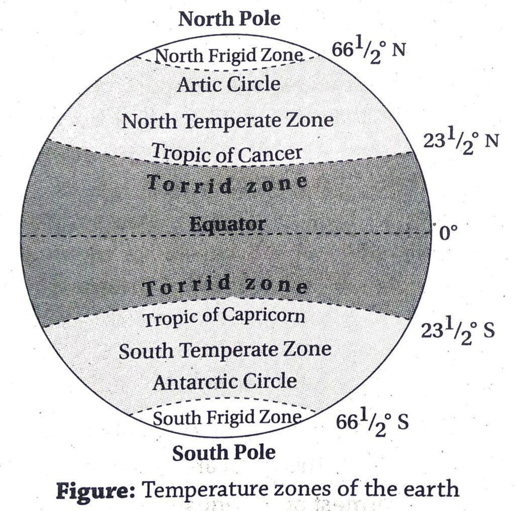
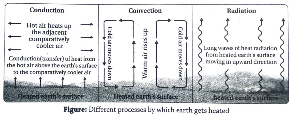
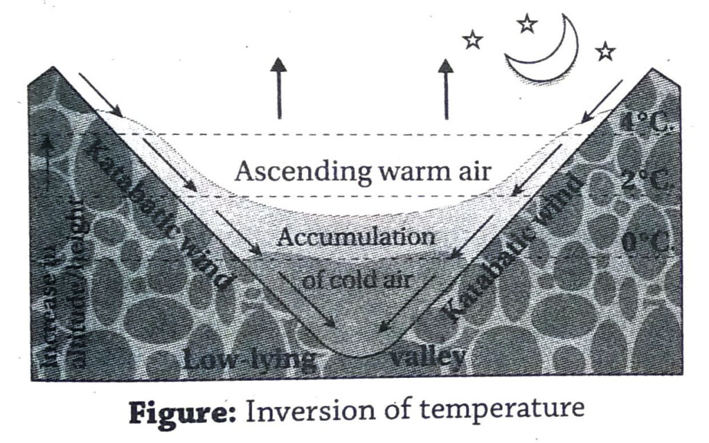
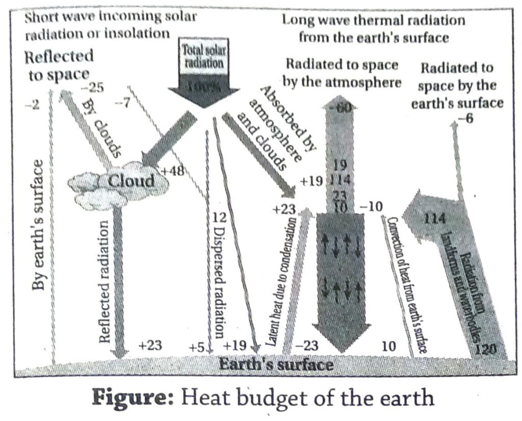
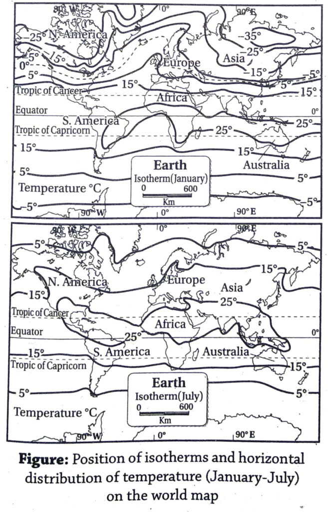

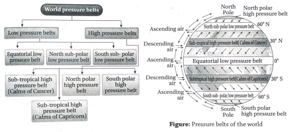

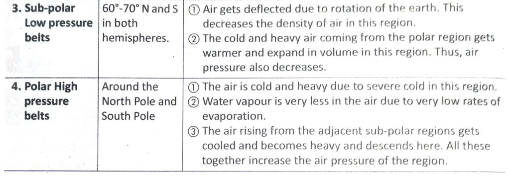

 If the jet stream moves northwards from it normal position, the monsoon winds get interrupted. This is known as the break of monsoon. The creation of low pressure cells in the monsoon season, formation of cyclones and their intensities are also dependent on the jet stream.