Ladakh Plateau: The Ladakh plateau lies in the north-east of the Ladakh range. Average height of the plateau is 4300m or more. This is the highest plateau in India.
Physical Characteristics: 1. The highlands have been eroded heavily through ages and have been lowered considerably. The average height of the highlands is 700m. Many places of the highlands have been lowered to form peneplains. 2. The highest region of the Chotanagpur plateau is the Pat region in the western side (above 1000m high). The Ranchi plateau lies east of the Pat region. The river Damodar flows between the Ranchi and the Hazaribag plateaus. The Rajmahal hills occupy the north-eastern corner of the Chotanagpur plateau. Parasnath (1365m) is the highest peak of the Rajmahal hills. 3. The middle part or central part of the Mahanadi basin lying to the south of the Baghelkhand plateau is known as the Chhattisgarh basin. 4. South of the Chhattisgarh basin lies the rugged and dissected hilly area of Dandakaranya. The highest place of this region is Koraput. 5. South of the Ranchi plateau lies the hilly region of Odisha, comprising hills of Sundargarh, Garhjat, Bamra, Kandhamal and Kondhan hills.
Location: The Kachchh peninsula lies north of the Kathiawar peninsula. The northern and eastern side of the Kachchh peninsula is bordered by the Rann of Kachchh. The larger portion of the Rann lying in the north is known as the Great Rann and the smaller portion in the south is known as the Little Rann. The Great Rann is bordered by the Arabian Sea and the Little Rann is bordered by the Gulf of Kachchh in the west.
Landform: The Rann of Kachchh is a shallow, salty marshland. The northern part is known as the Great Rann and the southern part is known as the Little Rann. The Rann extends over an area of about 7500 sq km. The Luni river flows along the north of the region. A few low hills are present in this region. E.g.-Osam, Barda, etc. The region lies between a very hot desert on one side and the Arabian Sea on the other side. Previously, this region was submerged under the sea and it appeared to be a shallow extension of the Arabian Sea. Presently, the region lies as a salty marshland during the rainy season, but remains as a dry, arid, treeless region covered in a white sheet of salt and sand during the dry summer season.
Ans. The islands of India are divided into two parts according to their location-1. Islands of the Bay of Bengal and 2. Islands of the Arabian sea.
- Islands of the Bay of Bengal: The Andaman and Nicobar islands are the main islands of the Bay of Bengal. These islands are basically the risen parts of a submerged mountain range. Thus some hills and peaks are seen in different parts of the islands. The average height of these hills is 400-500 m. The highest peak of the islands is the Saddle peak (732 m). Mt. Harriet of South Andaman island is a famous peak. There are two active volcanoes present here, namely, Barren and Narcondam. The Barren had erupted several times and the last eruption occurred in 2017.
Apart from the Andaman and Nicobar islands, other islands on the Bay of Bengal are Wheeler and Stork islands near the Odisha coast, Sriharikota in Andhra Pradesh and Pamban island near Coromandel coast.
-
Islands of the Arabian sea: The islands of the Arabian sea are Amindivi, Laccadive, Minicoy, etc. They are together known as the Lakshadweep islands. The islands have been formed by the deposition of the shells of coral polyps. Hence, they are called coral islands. The other islands of the Arabian sea are-Diu (Kathiawar coast), Salsette (Maharashtra), Vypin and Willingdon (Kerala), etc.
16. Mention the geographical importance of the islands in India.
Ans. The islands of India are geographically very important.
- Timber Industry: The dense forests of the islands help in the development of timber industry.
- Cottage Industries: Small and cottage industries like matchstick, plywood, conch shells, coir items, shell items, etc. develop in the islands.
- Fishing: Being located in the seas, fishing is a popular occupation of the island inhabitants. The fish caught is either sold or consumed by the inhabitants themselves.
- Tourism: The scenic beauty of the islands and the surrounding sea attract tourists from India as well as from abroad. This helps in the economic development of the islands.
- Ports: Islands are ideal places for port activity. Several ports have been developed in the islands which favour export and import of goods.
17. Classify the plains of the Western Coast of India.
Ans. The coastal plains of western India can be classified into four parts-
- Gujarat Coastal Plain: This lies between the Kachchh and Kathiawar peninsulas of Gujarat in the north and the northern margins of Maharashtra in the south.
- Konkan Coastal Plain: This is a narrow and broken coast lying between northern margin of Maharashtra in the north and Goa in the south.
- Karnataka Coastal Plain: This is also a narrow and broken coastal plain stretching between southern Goa in the north and the northern border of Kerala in the south.
- Malabar Coastal Plain: This lies between northern border of Kerala in the north and Kanyakumari in the south.
18. Classify the Eastern Coastal plains.
Ans. The Eastern Coastal plains can be classified into two parts-1. The Northern Circars coast extending from the mouth of the Subarnarekha river in the north to the delta of the Krishna river in the south. 2. The Coromandel coast extending from the delta of the Krishna river in the north to Kanyakumari in the south.
The Eastern Coast can also be classified according to states-1. Odisha coastal plain, 2. Andhra coastal plain and 3. Tamil Nadu coastal plain.
19. Describe the Konkan plain.
Ans. The Konkan Coastal plain lies in the Western Coastal plains of India. It stretches from the northern margins of Maharashtra in the north to Goa in the south. The coastal plain is about 500 km long, only 50-80 km wide, broken and rocky. Some parts of the plain is sandy and composed of limestone. This coastal plain has sea cliffs, shoals, reefs and islands in the Arabian Sea.
20. Describe the plains of the Malabar coast.
Ans. The southern part of the Western Coastal plains along the Arabian Sea in Kerala is known as the Malabar coast. It stretches between south of Mangalore in the north and Kanyakumari in the south. It is about 500 km long and 25 km wide. The presence of lagoons, backwaters, spits, etc. is a significant characteristic of the Malabar coast. The famous lagoons and backwaters of this coastal plain are Vembanad, Asthamudi, etc.
21. Which region is known as the Northern Circars coast?
Ans. The northern part of the Eastern Coastal plains of India lying along the Bay of Bengal is known as the Northern Circars coast. It stretches from the mouth of the river Subarnarekha in the north to the delta of the river Krishna in the south. It includes the whole of the Odisha coast and the northern part of the Andhra coast. The famous lagoon Chilka and Kolleru lake are located here. The deltas of the rivers Godavari and Krishna also lie here.
22. Where is the Coromandel coast located?
Ans. The southern part of the Eastern Coastal plains of India is known as the Coromandel coast. It stretches from the Krishna delta in the north to Kanyakumari in the south. This plain lying along the Bay of Bengal include the southern part of the Andhra coastal plain and the whole of the Tamil Nadu coastal plain.
23. Why is the Western coast more broken as compared to the Eastern coast?
Ans. The western coastal region of India has been formed due to earth movements, when the western part of the Western Ghats were raised and submerged for several times. Thus, the coast is narrow and broken. The eastern coast on the other hand has been formed by deposition of materials brought down by rivers. Thus, it is continuous, gentle and gradually meets the sea.
Short Answer Type Questions
1. In how many parts can India be divided according to relief?
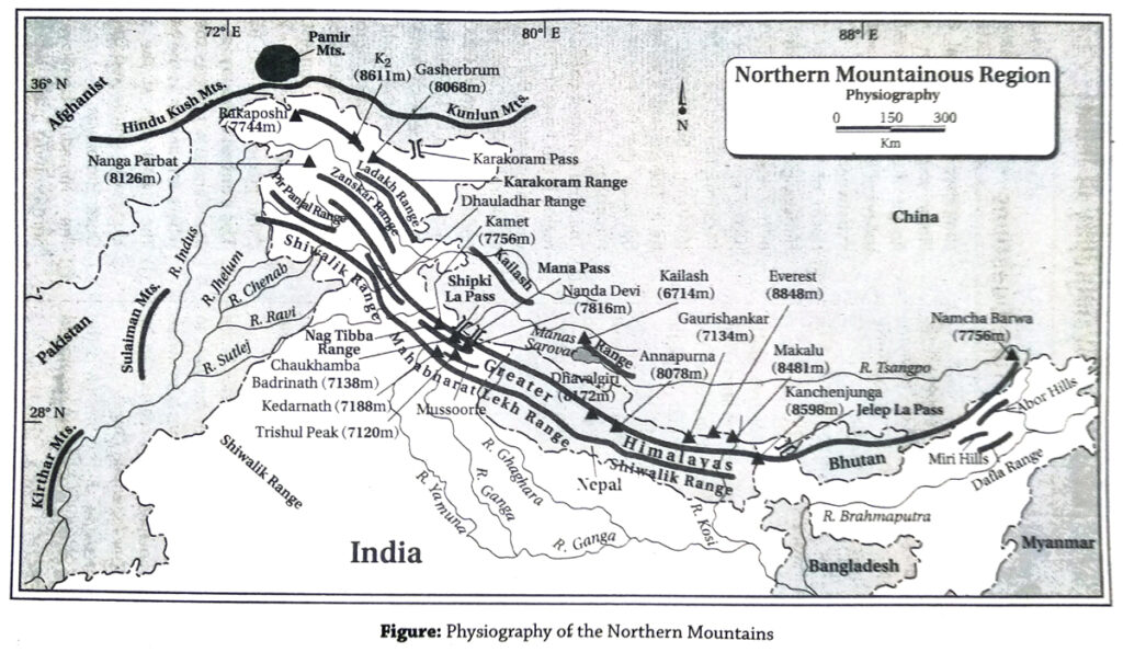
Ans. India can be divided into five parts according to relief-1. The Northern Mountains, 2. The Northern Plains, 3. The Peninsular Plateau region, 4. The Coastal Plains and 5. The Islands.
2. Name three lakes and three passes in the Himalayan range.
Ans. Lakes: 1. Nainital in Kumaon Himalayas, 2. Dal and 3. Wular in Kashmir valley.
Passes: 1. Banihal pass in Jammu and Kashmir, 2. Baralacha La in Himachal Pradesh and 3. Nathu La pass in Sikkim.
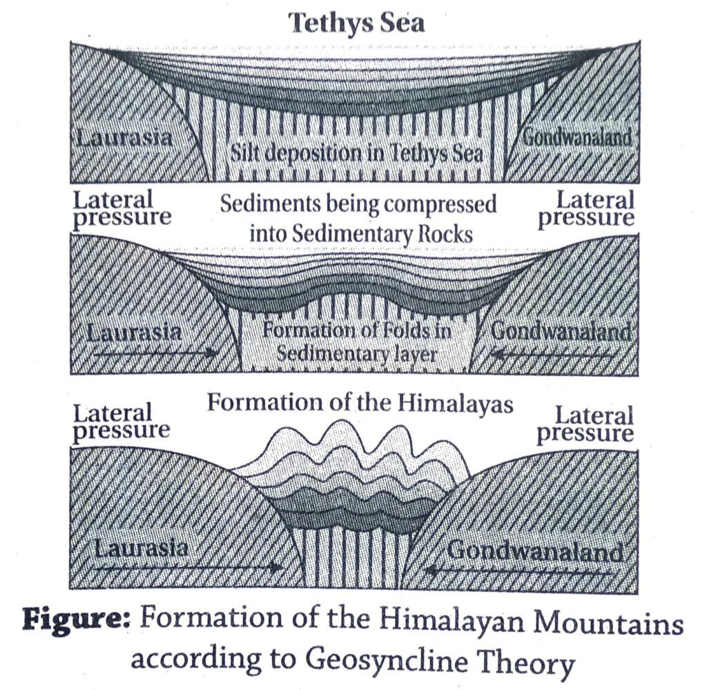
3. When were the Himalayas formed?
Ans. According to the geological calender, the formation of the Himalayas started in the Tertiary Age, i.e., about 60-70 million years ago. The Himalayas is still rising. That is why they are called the new fold mountains.
4. Classify the Himalayan mountains.
Ans. The Himalayas can be classified according to the length as well as according to the width.
1. Classification according to the length: (1) Western Himalayas, (2) Central Himalayas and (3) Eastern Himalayas.
2. Classification according to width: (1) Trans or Tethys Himalayas, (2) Greater Himalayas or Himadri Himalayas, (3) Lesser Himalayas or Himachal Himalayas and (4) Outer Himalayas or Siwalik Himalayas.
5. What do you mean by Purvanchal?
Ans. The hilly and mountainous region in the north-eastern states of India is called the Purvanchal. These hills and mountain ranges are spread over Arunachal Pradesh, Assam, Nagaland, Manipur, Mizoram, Tripura, etc. The most notable ranges found here are Patkai hills, Barail range, Naga hills, Lushai hills, Mishmi hills, Garo hills, Khasi hills, Jaintia hills, etc.
6. What is a doon?
Ans. In the Western Himalayas, the asymmetrical, longitudinal synclinical valley between the Lesser or Himachal Himalayas and the Outer or Siwalik Himalayas is known as the ‘doon’. It extends over a length of 34 km and the average width is 20 km. It is an almost plain land, E.g.-Dehradun (Uttarakhand), Udhampur (Jammu and Kashmir).
7. Which place is known as the ‘Paradise on Earth’?
Ans. The Kashmir Valley is known as the ‘Paradise on Earth’ because of the magnificient natural beauty found there.
8. Name the highest plateau and longest glacier of India.
Ans. Highest plateau: Ladakh plateau is the highest plateau of India.
Longest glacier: Siachen glacier in the Karakoram range.
9. Name the highest mountain peak and highest waterfall of India.
Ans. Highest mountain peak: Mt. Godwin Austen or K2 (8611m) of the Karakoram range.
Highest waterfall: Kunchikal waterfalls (455m) on the river Varahi in Karnataka.
10. Name some mountain ranges and hills of the Purvanchal.
Ans. Some of the mountain ranges of the Purvanchal are Patkai hills, Lushai hills, Garo hills, Khasi hills, Jaintia hills, Mishmi hills, Barail range, Naga hills, etc.
11. Name an old fold mountain and a new fold mountain of India.
Ans. Old fold mountain: Aravalli range in western India.
New fold mountain: Himalayan range in northern India.
12. Name two passes in the Himalayan mountains.
Ans. The two passes in the Himalayan mountains are-1. Nathu La pass in Sikkim in the Eastern Himalayas, 2. Banihal pass in Jammu and Kashmir in the Western Himalayas.
13. Name a mountain pass of the Himalayas and the Western Ghats.
Ans. Himalayas: Nathu La pass in Sikkim in the Eastern Himalayas.
Western Ghats: Thalghat gap near Nashik in Maharashtra.
14. Name two peaks that mark the eastern and western limits of the Himalayan mountain.
Ans. Eastern limit: Namcha Barwa (7782 m).
Western limit: Nanga Parbat (8126 m).
15. What is ‘Aksai Chin’?
Ans. Aksai Chin is the region (area 37,244km²) located in the north-eastern margin of Jammu and Kashmir at the border of China. This is an intermontane plateau located to the north-east of the Karakoram range. The average height of the region is 5000m, but some parts of it are as high as 6000m or more. Aksai Chin is now occupied by China. This is a politically disputed land.
16. What are the Soda plains?
Ans. The north-eastern corner of Jammu and Kashmir is known as the Soda plains. This region lies to the north-east of the Karakoram range and is a part of Aksai Chin. Physiographically, it is a highland, whose surface is a gently undulating land, lacking surface irregularities.
17. Where are the Siwalik mountains located?
Ans. The southernmost or the outer ranges of the Himalayas are known as the Siwalik mountains. They run from western part of Jammu and Kashmir in the west to Arunachal Pradesh in the east. The Siwalik mountains are the lowermost range of the Himalayas. South of the Siwalik lies the great northern plains of India.
18. Name the different ranges in the Kashmir Himalayas.
Ans. The Kashmir Himalayas can be divided into eight west to east trending ranges from south to north. They are-1. Siwalik, 2. Pir Panjal, 3. Himadri Himalayas, 4. Zanskar, 5. Deosai, 6. Masherbrum, 7. Ladakh and 8. Karakoram.
19. What is the Trans-Himalayan region?
Ans. The region lying between the northern part of the Himadri Himalayas and the Tibetan plateau is known as the Trans or Tethys Himalayan region. The mountain ranges of Deosai, Masherbrum, Zanskar, Ladakh and Karakoram and the Ladakh plateau and the Indus Valley lie in this region.
20. Name the oldest mountain and the highest peak of India.
Ans. The oldest mountain of India is the Aravalli range. The highest peak of India is the Mt. K2 (8611m) or Godwin Austen in the Karakoram range.
21. What is Karewa?
Ans. It is an intermontane valley fill, comprising of unconsolidated gravel and mud of glacial origin. Karewa is found in the form of terraces above the plain of Jhelum and its tributaries at a height of 100-200 m and is locally known as ‘Karewa’ or ‘Vudr’. The river Jhelum flows through the Karewa. This soil is good for cultivation of saffron.
22. Why are the Northern plains of India known as the storehouse of food grains?
Ans. The Northern plains are very fertile and suitable for agriculture. Large number of crops are grown in this region, for example-rice, jute, sugarcane, wheat, cotton, pulses, oilseeds, etc. Thus, it is known as the storehouse of food grains in India.
23. What are dhrians?
Ans. The moving or shifting sand dunes of the Thar desert are known as dhrians. In the desert, speedy winds force the sand dunes to move from one place to another along the direction of the wind.
24. What is the Rann of Kachchh?
Ans. In Gujarat, in the peninsula of Kachchh, the shallow salty marshes are known as the Rann. The Rann of Kachchh is subdivided into two parts-the Great Rann and the Little Rann.
25. Why is Marusthali called so?
Ans. The name ‘Marusthali’ comes from the words ‘Maru’ meaning dead and ‘sthali’ meaning land. Thus, Marusthali means ‘land of the dead’. In Rajasthan, the western part of the Thar desert is almost treeless and lifeless and has no habitation. Thus, it is called Marusthali.
26. What is khadar and bhangar?
Ans. The plain created by the new alluvium deposited along the banks of the river Ganga and its tributaries is known as khadar. The plain created a little away from the khadar region, composed of old alluvium is known as bhangar. The khadar region is more fertile than the bhangar region.
27. What is bhabar?
Ans. The northern part of the Gangetic plain is known as bhabar. This lies at the foothills of the Himalayas. The region is made up of rocks, stones, pebbles, gravels, etc. brought down by the numerous rivers coming from the Himalayas. This region is highly porous where many small stream percolate down and lose their ways.
28. What is rohi?
Ans. Concept: The region lying to the west of the bagar region in the desert of Rajasthan is known as rohi.
Formation: A number of small rivers or streams rise in the Aravalli range and flow westwards through the desert region. The streams remain dry for most of the time in the year, but get flooded during the rainy season. The plain thus created by the flooding of these streams is known as rohi.
29. What is bagar?
Ans. The region lying east of the desert region of Rajasthan at the foothills of the Aravalli range is known as bagar. This is a narrow region lying between the desert and the plains composed of little sand. Most of the bagar region remains covered with grass. Some parts of bagar are used for agriculture.
30. What is dhand?
Ans. The salt lakes found in the desert region of Rajasthan between two parallel sand dunes are called dhands. They are shallow and have large depositions of salt and remain dry for most of the time in the year.
Multiple Choice Type Questions [MCQ type]
Write the correct answer from the given alternatives
1. The oldest fold mountain of India is the-
A. Aravalli
B. Vindhya
C. Nilgiri
D. Himalayas
Ans. A
2. Which of the following is an important pass in the Eastern Himalayas?
A. Zoji La
B. Nathu La
C. Khardung La
D. Shipki La
Ans. B
3. Which of the following is known as ‘the Crown of the World’?
A. Karakoram
B. Mt. Everest
C. Pamir Plateau
D. Kanchenjunga
Ans. B
4. The Siachen glacier lies in the-
A. Karakoram range
B. Pir Panjal range
C. Zanskar range
D. Ladakh range
Ans. A
5. Patkai range lies in-
A. Jammu and Kashmir
B. Nagaland
C. Arunachal Pradesh
D. Himachal Pradesh
Ans. B
6. Kula Kangri is the highest peak of the …….. Himalayas.
A. Darjeeling
B. Bhutan
C. Kumaon
D. Kashmir
Ans. B
7. The second highest mountain pass of the world is-
A. Karakoram
B. Lachulung La
C. Tanglang La
D. Nathu La
Ans. A
8. The hot spring of Manikaran in the Himalayas lies in-
A. Uttarakhand
B. Sikkim
C. Himachal Pradesh
D. Kashmir
Ans. C
9. The Kashmir Valley is situated between the ranges-
A. Zanskar and Ladakh
B. Pir Panjal and Greater Himalayas
C. Karakoram and Ladakh
D. Dhuladhar and Nag Tibba
Ans. B
10. Two famous lakes in the Kashmir Valley are-
A. Mirik-Changu
B. Nainital-Sattal
C. Dal-Wular
D. Sambhar-Dhebar
Ans. C
11. The highest peak of India is-
A. Mt. Everest
B. Kanchenjunga
C. K2
D. Nanda Devi
Ans. C
12. The highest peak of the Arunachal Himalayas is-
A. Sandakphu
B. Gorichen
C. Nanga Parbat
D. Annapurna
Ans. B
13. The river that flows between the Ladakh and Zanskar ranges is-
A. Ganga
B. Sutlej
C. Beas
D. Indus
Ans. D
14. The Garo hills of Meghalaya are-
A. Residual hills
B. Fold mountains
C. Block mountains
D. Volcanic mountains
Ans. A
15. The river rising from the Kumaon Himalayas is-
A. Ganga
B. Indus
C. Brahmaputra
D. Krishna
Ans. A
16. The northern margin of India is marked by the-
A. Zanskar
B. Ladakh
C. Aravalli
D. Karakoram
Ans. D
17. The Mt. Everest is known as ……… in Nepal.
A. Tethys
B. Chomolungma
C. Sagarmatha
D. Akash Sakha
Ans. C
18. The longest tunnel in India is-
A. Bhatan tunnel
B. Pir Panjal tunnel
C. Rohtang tunnel
D. Jawahar tunnel
Ans. D
19. The ……… Valley lies between the Pir Panjal and Dhauladhar ranges.
A. Kullu
B. Kangra
C. Spiti
D. Dehradun
Ans. A
20. The highest part of Garo hills is-
A. Saramati
B. Dapha Bum
C. Nokrek
D. Anamudi
Ans. C
Very Short Answer Type Questions
Fill in the blanks with suitable words
1. The region where the Himalayas exist, was previously occupied by the ………. sea.
Ans. Tethys
2. The Himalayas were formed during the ………. geological age.
Ans. Tertiary
3. The highest point of the Singalila range is ………
Ans. Sandakphu
4. The highest peak of the Himalayan mountain is ………
Ans. Mt. Everest
5. The ……… range forms the boundary between West Bengal and Nepal.
Ans. Singalila
6. The highest hill of Tripura is ……….
Ans. Jampui
7. The southern most range of the Himalayas is ………..
Ans. Siwalik
8. The ……….. peak lies in the north-western part of the Himalayas.
Ans. Nanga Parbat
9. The Karakoram range is also known as the ………
Ans. Krishnagiri
10. The highest point of the Kohima Hill is ……….
Ans. Japfu
11: The valley formed between the Siwalik and the Himachal Himalayas is known as ………
Ans. Doons
12. The Himalayas extend from the ……….. knot.
Ans. Pamir
13. The Indus flows through the ………. Himalayas.
Ans. Kashmir
14. The soil called Karewa found in the Kashmir Valley is famous for ………. cultivation.
Ans. Saffron
15. The Kanchenjunga lies in the state of ………. in India.
Ans. Sikkim
16. In eastern Himalayas, the sharp hair-pin bends are known as ……….
Ans. Syntaxial bends
17. The only hot desert of India is located in ………
Ans. Rajasthan
18. The western part of the Indian desert is known as ……….
Ans. Marusthali
19. The ……… island of river Brahmaputra is the largest river bar of India.
Ans. Majuli
20. The only river of Marusthali is ………….
Ans. Luni
Answer in one or two words
1. Which mountain pass connects Srinagar and Jammu?
Ans. Banihal Pass.
2. What is the valley between Lesser Himalayas and the Siwalik range called?
Ans. Doon.
3. Name two ranges of the Lesser Hamalayas.
Ans. Pir Panjal and Mussourie.
4. Which is the highest part of the Himadri Himalayas?
Ans. Mt. Everest.
5. Which is the highest peak of the Himalayas located in India?
Ans. Kanchenjunga.
6. Which mountain pass connects Kashmir Valley with Ladakh?
Ans. Zoji La Pass.
7. From where does the Yamunotri glacier flow?
Ans. Garhwal-Kumaon Himalayas.
8. Which mountain peak lies at the Nepal-Sikkim border?
Ans. Kanchenjunga.
9. Name the highest mountain pass of the world.
Ans. Sia La (5589m).
10. Name a cold desert in India.
Ans. Ladakh.
11. Which is the highest plateau of India?
Ans. Ladakh.
12. Where has been the highest bridge of the world constructed?
Ans. Between the Dras River and Suru River in Ladakh.
13. Name the highest peak of the Purvachal Himalayas.
Ans. Dapha Bum.
14. What was there previously where the Himalayas have formed now?
Ans. Tethys Sea.
15. In which Union territory is the Pangong Lake situated?
Ans. Jammu and Kashmir.
16. In which state of India are Gangotri, Yamunotri, Kedarnath and Badrinath located?
Ans. Uttarakhand.
17. What are the lakes in Kumaon Himalayas called?
Ans. Tal.
18. Where is Karewa soil found in India?
Ans. Kashmir valley.
19. Name the highest lake in India.
Ans. Tso Lhamo lake in Sikkim (5330m).
20. What do you mean by ‘La’?
Ans. Mountain pass.
21. Name the oldest mountain range of India.
Ans. Aravalli.
22. What are the dry lakes of Rajasthan called?
Ans. Dhands.
23. Name the largest lake of the Thar desert?
Ans. Sambhar lake.
24. Which mineral resource is found in the desert region of India?
Ans. Mineral oil.
25. Name two mountain ranges in Gujarat.
Ans. Gir and Girnar.
26. What do you mean by Rann?
Ans. Salt marshes found in the Kachchh peninsula of Gujarat.
27. Name the highest peak of the Meghalaya plateau.
Ans. Shillong peak (1961 m).
28. Name the highest peak of the Nilgiris.
Ans. Doddabetta (2637m).
TOPIC – 3
Water Resources of India
Long Answer Type Questions
1. Describe the courses of the three major rivers of northern India.
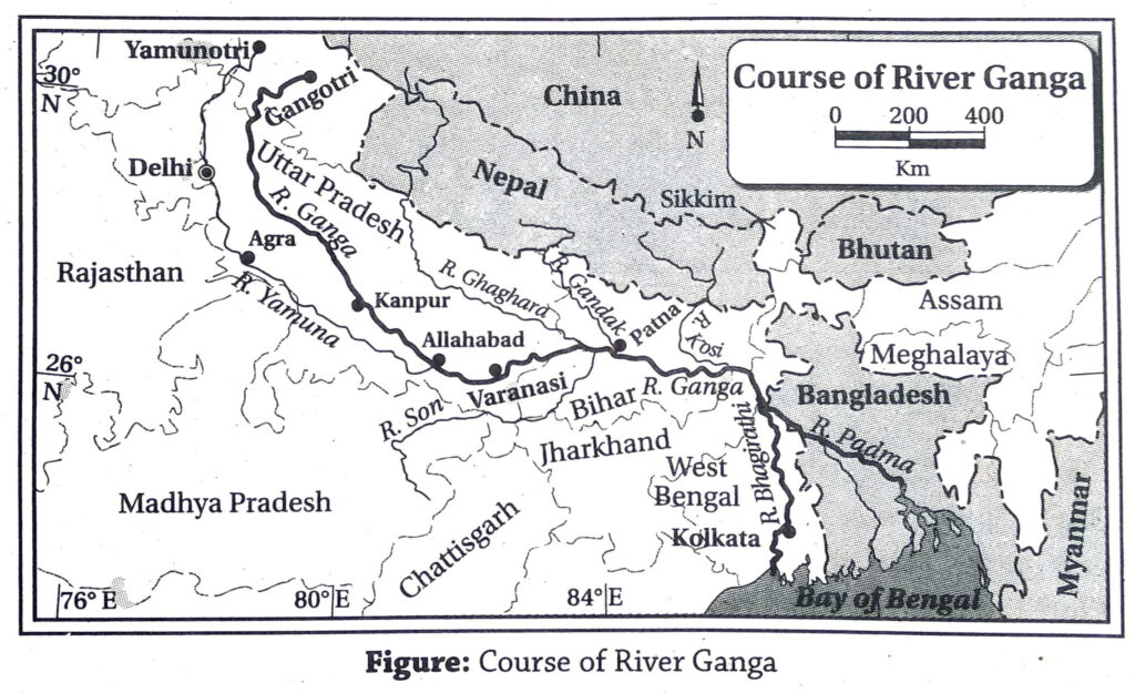
Ans. The three major rivers of northern India are-the Ganga, Indus and Brahmaputra.
- The Ganga: The total length of river Ganga is 2525 km, of which 2017 km lies in India. This is the most important river of India. The course of the Ganga can be divided into three parts-
- Upper Course: The river Ganga rises from the Gomukh cave of the Gangotri glacier in the Garhwal Himalayas. Here the river is known as the river Bhagirathi. The river Alaknanda meets the river Bhagirathi at Devaprayag, and the combined flow is known as the river Ganga. The stretch of the river from its source upto Haridwar is known as its upper course.
- Middle course: The middle course of the river Ganga stretches from Haridwar to the Rajmahal hills. The right bank tributaries Yamuna and Son and the left bank tributaries Gomti, Ghaghara, Ramganga, Gandak, Kosi, etc. meet the river Ganga in this course and multiply both its load and volume of water. The most important tributary of the river Ganga is the river Yamuna.
- Lower course: The lower course of the river Ganga extends from south of Rajmahal hills to the mouth in the Bay of Bengal. The Ganga after entering West Bengal bifurcates into two branches near Dhulian of Murshidabad. One of the branches enter Bangladesh as Padma and later drains into the Bay of Bengal as the river Meghna. The other branch flows through West Bengal as the Bhagirathi-Hooghly river before meeting the Bay of Bengal. The right bank tributaries in this course are-Ajay, Damodar, Kangsabati and Rupnarayan. The left banks tributaries are- Jalangi, Mathabhanga, Churni, etc. The river Ganga together with the river Brahmaputra forms the largest delta in the world.
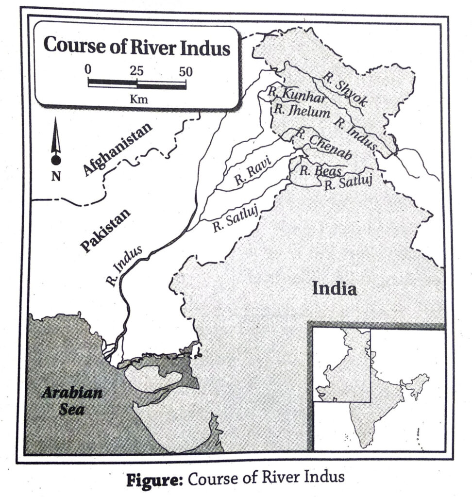
- The Indus: The Indus is the longest and the most important river of north-western India. It stretches for 2900 km, of which 1114 km lies in India. It rises from the Senge Khabab glacier near the Manas Sarovar in the Greater Himalayas. It flows through Jammu and Kashmir and then turns southwards near Nanga Parbat, entering Pakistan. From there it flows southwards and meets the Arabian Sea (south-east of Karachi).
The most important left bank tributaries of the river Indus are-Jhelum, Chenab, Ravi, Beas and Sutlej. These tributaries flow over Jammu and Kashmir, Himachal Pradesh and Punjab. The right bank tributaries are- Shyok, Gilgit, Shigar, etc. The river Indus forms deep gorges near the Nanga Parbat massif. It forms a small delta at its month.
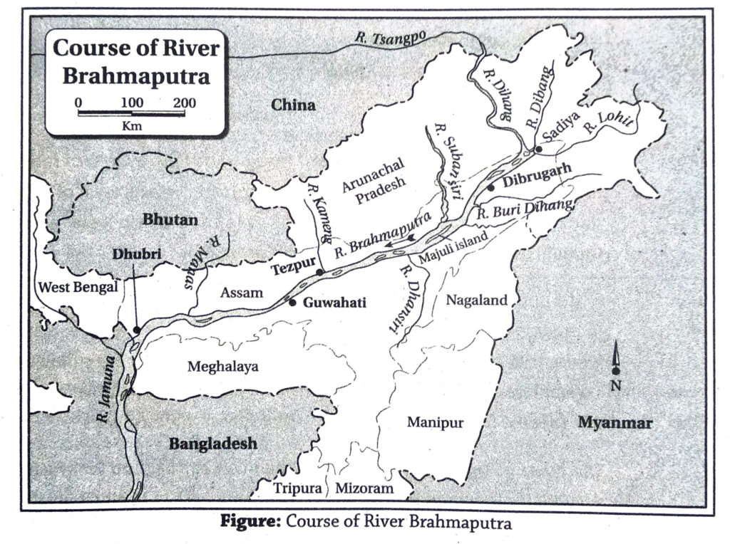
- The Brahmaputra: The river Brahmaputra is the most important river of north-eastern India. It flows for 2900 km, of which 916 km lies in India. The river rises from the Chemayungdung glacier in Tibet. Here it flows as river Tsangpo over the Tibetan plateau for about 1500 km. Near the Namcha Barwa peak it takes a sharp turn towards the south-west and enters Arunachal Pradesh as river Dihang. The Dihang meets the rivers Dibang and Lohit near Sadiya in Assam. The combined flow of these three rivers flow as the river Brahmaputra westwards over Assam till Dhubri. From Dhubri it turns southwards and enters Bangladesh as the river Jamuna. It meets the river Padma near Goalondo and enters the Bay of Bengal. The course of the river Brahmaputra in Assam is highly braided, forming several islands. The island of Majuli near Jorhat in Assam is the largest riverine island in India. Some important right bank tributaries of the river Brahmaputra are- Subansiri, Kameng or Jiya Bharali, Manas and Sankosh. Some left bank tributaries of the river Brahmaputra are- Dhansiri, Kopili and Buri Dihing.
2. Write the importance of rivers in thelivelihood of the people of India.
Ans. The importance and role of rivers in the livelihood of the people of India are-
- Agriculture: The rivers have deposited fertile alluvial soils and provide sufficient water for agriculture in the catchment areas.
- Transport: Rivers help in inland transport of goods and passengers at cheap rates. This helps in trade and commerce within the places located along the river banks.
- Pisciculture: Pisciculture is practiced in the rivers to produce huge quantities of fish. This is used to meet the protein demand of the people as well as for trade.
- Hydroelectricity: The mountainous rivers are harnessed for generating hydroelectricity. Also, multi-purpose projects are built on large rivers for generating electricity, irrigation, pisciculture, flood control, tourism, etc.
- Industrial growth: The demand of water in industries is met by the river water. In many cases, the produced goods are also traded through waterways within the country.
- Drinking water: River water is purified and supplied as drinking water especially in urban areas.
- Others: River sides are famous for tourism due to their scenic beauty. E.g.-Diamond Harbour, Taki, Ghatsila. They also play an important role in conservation of the aquatic ecosystems.
3. Discuss the necessity of irrigation in India.
Ans. Irrigation is very important for agriculture in India for the following reasons-
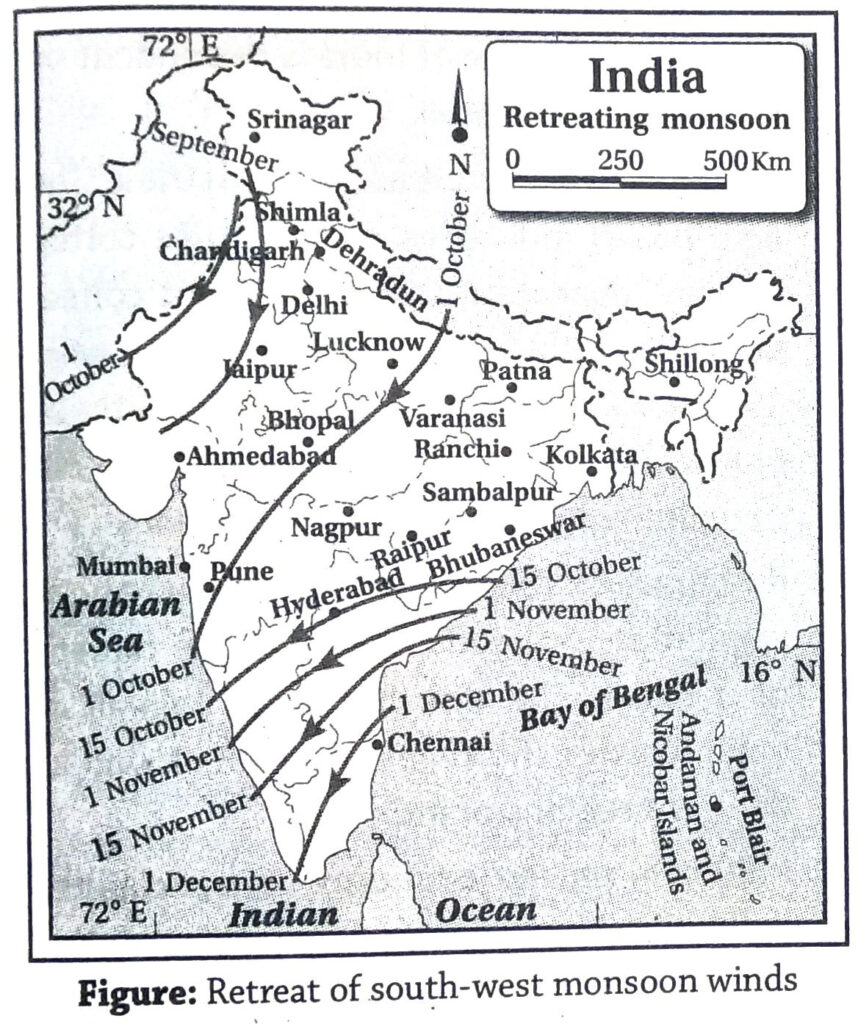
- Uncertain monsoon rainfall: Indian agriculture is highly dependent on monsoon rainfall. About 67-72% of the total annual rainfall in India occurs during June-September. However, the onset and retreat of the monsoon winds is highly uncertain. This may lead to crop failure. Hence, irrigation is absolutely necessary.
- Uneven distribution of rainfall: Rainfall is not evenly distributed all over the country. The north-eastern states receive more than 200 cm of rainfall, whereas the north- western states receive as low as 75 cm of rainfall on an average. Hence, irrigation is essential for agriculture in Rajasthan, Punjab, Haryana, Gujarat and parts of Deccan plateau.
- Dry winters: The winters are generally dry in India. Only a few regions in the north- western part and the Coromandel coast in the south-eastern coastal region receive some rainfall in winter. Hence, irrigation is necessary for cultivation of rabi crops like wheat, pulses, barley, oilseeds and boro rice.
- Different water holding capacities of soils: Soils like laterite and red soil have en very low water holding capacity. Thus, irrigation is needed in order to conduct agriculture on those soils.
- HYV seeds: The High Yielding Variety seeds are now increasingly used in the country to raise the yield of crops. However, they need huge amounts of water for best results. Hence, irrigation is necessary.
- Agriculture round the year: Each agricultural plot is cultivated 3-4 times a year in order to increase total crop production in the country. This cannot be done unless irrigation water is available.
4. What do you understand by watershed development? Discuss its importance and processes of development.
Ans. The general development of any river catchment area and the water divide for overall development of the ecosystem, environment and water resource is known as watershed development.
Importance: 1. Identification of the water divides helps to identify the catchment area of a river system. 2. The methods of watershed management and its development depend upon the nature of the rivers and the characteristics of the catchment area. 3. The amount of water found on the surface and underground in a catchment area depends upon the area covered by the rivers, availability of rainfall, porosity of the rocks, etc.
Processes of development:
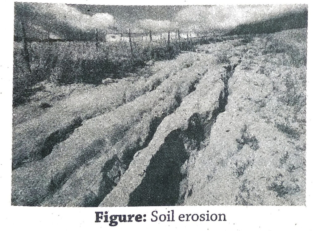
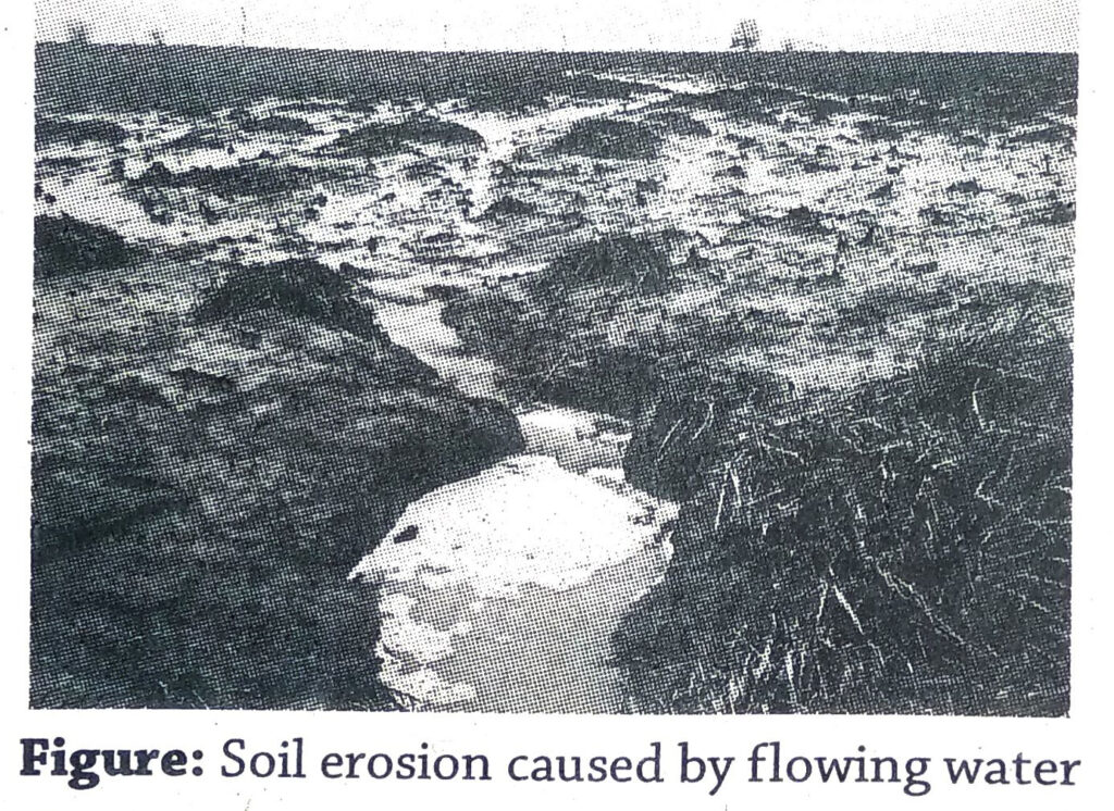
- Management of slope: The steep slopes of mountainous regions are prone to heavy soil erosion. To control this, afforestation, weaving grass on open lands, building guard walls for controlling landslides or changing the path of the mountainous course of the rivers may be done. Bad practices of agriculture like Jhum cultivation must be stopped.
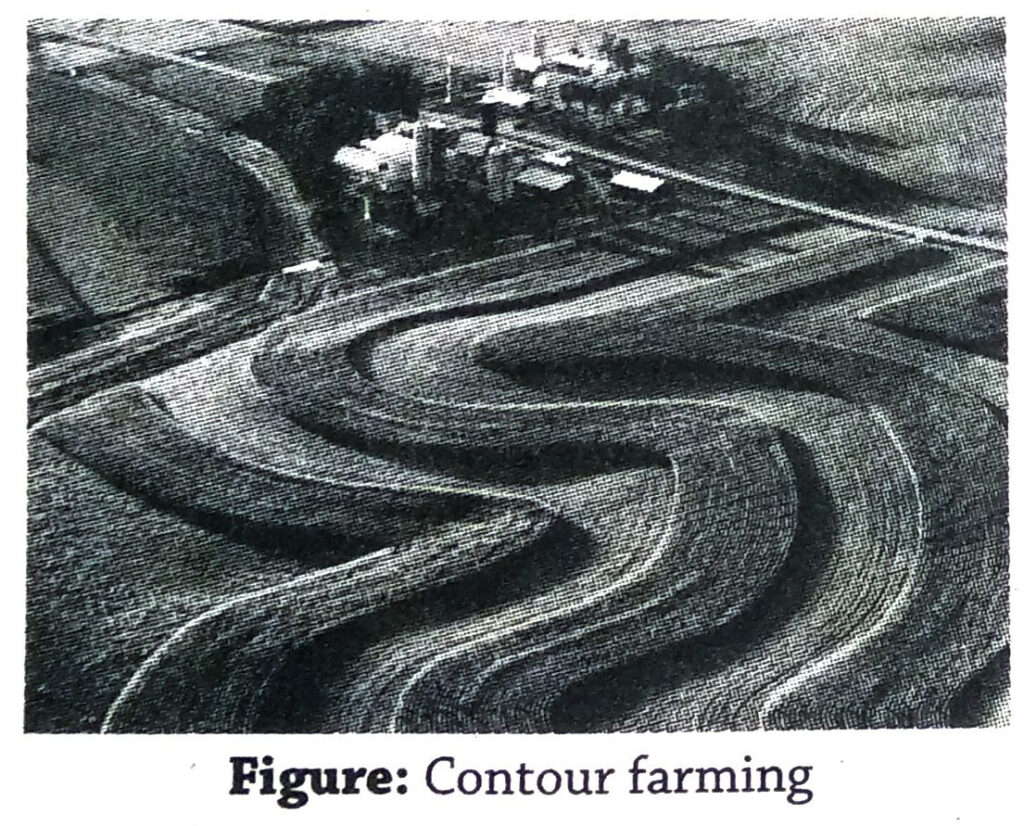
- Afforestation along contour lines: Planting of trees along the contours in step farming help to reduce soil erosion, and increases recharge of underground water by percolation.
- Check-dams across river: Small and low check-dams built across small rivers in the catchment area helps to conserve water locally and reduces soil erosion.
- Flood control: In case of flood-prone rivers, several wetlands, ponds and canals may be dug and the silt of the rivers may be removed in order to increase the water holding capacity of the rivers. The excess water may flow into the canals and reservoirs dug for the purpose and help in controlling floods.
- Multi-purpose river valley projects: Multi-purpose river valley projects are taken up in river catchment areas for the purpose of flood control, prevention of soil erosion, irrigation, navigation, generation of hydroelectric power, pisciculture, etc.
5. Discuss the factors which help in irrigation in India.
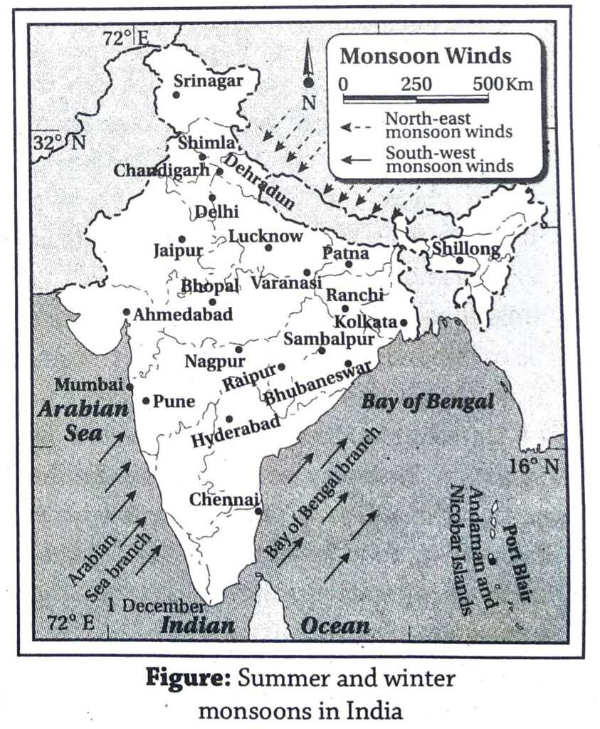
Ans. India is the land of many snow covered mountains and numerous rivers. It also receives huge amounts of rainfall from the south-west monsoon winds. Hence, there are a number of factors which assist irrigation in the country in order to carry out agriculture. Thus, the factors which help in irrigation are discussed below-
- Snow-fed rivers: The rivers of northern India are snow-fed, and have water throughout the year. Thus, canals can be dug from the rivers to the agricultural fields to carry out cultivation throughout the year.
- Vast plain land: The soft soils of the vast plains of North India allow easy construction of canals for irrigation.
- High water table: The northern part of India receives heavy amounts of rainfall, which percolates down gradually through the soft alluvial soils and recharge underground water. Thus, the water table lies only a little below the surface of the land. This water can easily be utilised by digging wells and tube wells.
- Rainfall: Sufficient rainfall during the rainy season fills up the rivers, canals, ponds, lakes, reservoirs and tanks. This water can be stored for use in the dry season.
- Construction of dams: The rivers of south India flow through undulating terrain of the plateau. The rivers make waterfalls and are suitable for generating hydroelectric power. Thus, they are dammed at places and the water is stored in natural reservoirs in the plateau. This is used for irrigation and other purposes during the dry season.
6. Discuss the reasons behind the usefulness of canal irrigation in India.
Ans. Canals are a common means of irrigation in India. Canals are of two types- (1) The perennial canals are those that have water throughout the year and can irrigate fields in all the seasons. (2) The inundation canals are those that have water only when the rivers are flooded, and can irrigate fields only in the rainy season. The reasons behind the usefulness of canal irrigation in India are-
- Numerous rivers: India is a land of numerous rivers spread like a network over the country. Thus, canals can be easily drawn from these rivers to irrigate fields.
- Snow-melt water: The rivers of North India are snowfed. They have water throughout the year. Thus, canals drawn from them are also perennial and are used to irrigate the agricultural fields throughout the year.
- Landforms: The northern part of India is a vast plain land made up of soft alluvial soils. Thus, it is easy to draw canals from the rivers through the plains according to need.
- Slope of land: The general slope of the land in India is from west to east. The canals can thus carry water easily from the rivers to the fields along the gently rolling plains.
- Reservoirs: In southern India, the undulating topography provides natural depressions on land that can be used as reservoirs or tanks. Water is stored in these reservoirs in the rainy season..Canals can be dug from these reservoirs to meet the demand of water in the dry season.
- Underground water: In many regions in India, the underground water level has gone down so low, that it is difficult to draw out water through the wells and tube wells. Thus, dependence on surface water has increased. Canals are the easiest way to divert river water to the fields. In India, presently about 26% of agricultural fields are irrigated by canals.
7. Discuss the effects of excessive irrigation.
Ans. The effects of excessive irrigation are as follows-
- Deficiency of oxygen: Too much of irrigation tend to fill up the air spaces within the soil with water. This drives out the air from the soil. The roots of the plants fail to absorb sufficient oxygen from the soil. Hence, the growth of plants is hampered.
- Disease of plants: Bacteria and germs tend to multiply fast in waterlogged soil. They attack the roots of the plants and result in their decay. Also, growth of fungus on the stems, leaves and fruits of the plants cause various plant diseases.
- Toxic chemicals: Stagnation of water in the soil for a long time causes accumulation of toxic chemicals like hydrogen sulphide and volatile fatty acids.
- Reduction of fertility: Agriculture is carried out in the fields throughout the year using irrigation and growing the same crop. This constantly reduces the fertility of the soil. After few years, the fertility may reduce to such an extent that the soil fails to grow any more crop at all.
- Increase of salinity: Excessive irrigation causes the salts deposited in the lower layers of the soil to dissolve in the water and rise up to the top layers. This gradually makes the soil more saline.
- Lowering of water table: Supply of irrigation water in one area may result in lowering of water table in the area from where the water has been drawn out through wells and tube wells.
- Others: (1) Excessive irrigation may result in changes in the ecosystem and affect the environment. Excess irrigated water mixed with fertilisers and pesticides when drains into the nearby water body causes water pollution. (2) Chances of water-borne diseases may increase. (3) Arsenic pollution and contamination of water may occur.
8. Discuss the importance of conservation of water.
Ans. The proper and judicious use of water is known as conservation of water. In other words, conservation of water refers to optimum and logical use of water, control of wastage, reduce unscientific and reckless use of water, water resource management and storage for future use.
Importance: Shortage of fresh and potable water is a burning problem all over the world. More than 50% of the world’s population suffer from scarcity of water. This accounts for about40% of the population in about 80 countries. Although nearly three-fourths of the earth’s surface is filled with water, 97% of it is saline and unusable. Only about 3% of the total water is fresh, but only 0.3% is easily available in rivers, ponds or lakes. With the increase in population, demand for water also increases, and per capita availability of water gradually decreases. Unplanned extraction of groundwater to meet the rising demand of water has lowered the water table in some areas to such an extent that acute scarcity of water has resulted in those areas. In India, 15% of the total block of the country suffer from acute crisis of water. Unless the available water is used carefully, logically and planfully, more areas will face water crisis in the future. Hence, conservation of water is very important and necessary in India.
9. Discuss the methods of watershed development.
Ans. Definition: The overall scientific development of the watershed of a river is known as watershed development. This includes conservation of the ecosystem, development and proper management of resources and overall development of the region. Methods: Several steps have been taken up in the process of watershed development-
- Slope management: The high and steep slopes of the upper course of the rivers are prone to landslides and soil erosion. These slopes are taken care of by planting trees, covering the open soil with grasses, prohibiting jhum cultivation, building guard walls along the tree beds and even diverting the course of the rivers from where the slope is very steep and dangerous.
- Flood control: The depth of ponds, canals, wetlands and even rivers is increased by digging out silt and mud. This increases the water holding capacity of the water bodies and helps to control flood.
- Badlands: Formation of badlands may be controlled by building check dams at several places, which will stop the flow of rainwater as surface run off and control soil erosion.
- Contour ploughing: Trees are planted along contour lines or particular heights, in order to prevent soil erosion. The forests thus created reduce the speed of the surface run off water and help in recharge of groundwater by percolation of rainwater.
- Small dams: Small dams are constructed on the rivers to control soil erosion and conserve water locally.
- Multi-purpose projects: Multi-purpose projects are undertaken for the purposes of flood control, generation of hydroelectric power, irrigation, pisciculture, navigation, controlling soil erosion, promotion of tourism and overall conservation of water.
10. Discuss about rainwater harvesting in India.
Ans. The method of collecting and conserving rainwater from the roofs or open ground to meet the demand of water is known as rainwater harvesting. The water thus collected is used all the year round for various purposes, especially in the dry season.
Methods of rainwater harvesting: Rainwater may be collected by different methods-
1. Collection of surface run off:
- Construction of reservoirs: Large reservoirs, tanks, ponds, etc. are constructed to hold rainwater and excess river water so that it can be used in the dry season. Accordingly, a pilot scheme was launched in 2005 to restore and augment storage capacity of water bodies. This scheme was approved in 26 districts across 15 states covering 1098 water bodies.
- Check-dams: Large dams are expensive to build, and often displace large number of people living along the rivers or in the catchment area. Check-dams or smaller dams are less expensive and helpful in holding river water in lesser amounts. This is a successful method of flood control as well.
- Collecting rainwater: India receives ample rain from the south-west monsoon winds. If this water can be held back properly, the crisis of water in the dry season can be met with. It is very essential to hold rainwater in West Bengal, Bihar, Jharkhand, Odhisa, Chhattisgarh, Madhya Pradesh, Andhra Pradesh and Karnataka in order to recharge the reserves of the water resource. Tamil Nadu has excelled in this regard by harvesting rainwater on rooftops since 2001.
- Proper use of surface water: The surface water stored in reservoirs, ponds and lakes are used for irrigation. Efforts can be made to increase the efficiency of using this water from 35-40% to 60%.
2. Conservation of groundwater:
- Implementation of rules and regulations: Implementation of rules and regulations will help to prevent unplanned use of groundwater, its misuse and wastage. This will help in conservation of groundwater.
- Increase the level of water percolation: In places where the land surface is open, the rainwater passes by very fast and does not percolate underground to recharge the groundwater table. In such cases, pipelines and other arrangements may be made so that rainwater reaches deep down and the underground water table is recharged.
- National policies: The ‘Swajaldhara’ project has been started in 2002 and the ‘Bharat Nirman’ project has been started in 2005-06 for distributing water in rural areas.
Short Explanatory Answer Type Questions
1. Why is the river Brahmaputra flood-prone?
OR, Why do floods occur in Assam every year?
Ans. The main river of Assam is Brahmaputra. Every year during the monsoon season, the river overflows its channel and flooding occurs in the lower Assam valley. The causes of flood in Assam are-
- Gentle slope of the land: The slope of the land in Assam valley through which the river Brahmaputra flows, is very gentle. Hence, the river loses its speed and load carrying capacity. Thus, the heavy amounts of load brought down by the river and its tributaries from the upper course get deposited in the river bed in this region. This reduces the depth and water holding capacity of the river, and makes it flood-prone.
- Heavy rainfall: The Assam valley receives heavy rainfall during the south-west monsoon season, which supplies huge quantities of water to the river Brahmaputra. Also, the snow melt water brought down from the upper course of the river (where it is known as Tsangpo, in Tibet) is added on. This increases the volume of water to such an extent that the river channel overflows. The result is severe flooding in the lower course of the river.
2. What is an ideal river? Why is the river Ganga called an ideal river?
Ans. Ideal river: A river which exhibits the upper, middle and lower courses from its source in the mountains or highlands to its mouth in the sea or ocean is called an ideal river. An ideal river generally erodes in the upper course, carries the load in the middle course and deposits the load in the lower course.
Ganga as an ideal river: The river Ganga rises in the Gomukh cave of the Gangotri glacier in the Greater Himalayas. The upper course of the river stretches from Gomukh to Haridwar. The middle course of the river extends from Haridwar to Rajmahal hills. From south of the Rajmahal hills to the mouth of the river in the Bay of Bengal through the vast delta region lies its lower course. As the river Ganga exhibits all the three courses prominently, it is called an ideal river.
3. Why deltas have not been formed on the mouth of west flowing rivers in India?
OR, Why do the rivers meeting the Arabian Sea not form deltas near their mouths?
OR, Why do the rivers Narmada and Tapti not form deltas near their mouths?
OR, Why deltas have not been formed at the mouth of west flowing rivers of India?
Ans. The west flowing rivers of India generally do not form deltas because-
- Short length of the rivers: The rivers flow for a short distance, and hence collect very little amount of eroded materials.
- Speed: The rivers (E.g.-Narmada and Tapti) flow through steep slopes of rift valleys. Hence, the water flows in high speed and removes whatever eroded materials are collected. Hence, chances of formation of deltas at their mouths is less.
- Less erosion: The rivers flow through a region made up of hard and resistant igneous and metamorphic rocks. Hence, rate of erosion is very less, which accounts for very less generation of silt.
- Lesser number of tributaries: The west flowing rivers have lesser number of tributaries. Thus, total load or eroded materials collected by the rivers is very less.
- Slope near the mouths of the rivers: The slope of the continental shelf near the mouths of the rivers is steep, which does not allow any deposition of silt. Hence, this repels the formation of a delta.
4. What are the main causes of pollution of the rivers of India? What steps have been taken up for controlling pollution of the river Ganga?
Ans. Causes of pollution of the rivers of India: 1. Disposal of wastes from households, factories and sewage lines into the rivers. 2. Disposal of dead animals into the rivers. 3. Washing down of pesticides and chemical fertilisers by rainwater into the rivers. 4. Bathing of domestic animals, washing of utensils and clothes in rivers. 5. Lack of consciousness regarding environmental pollution and degradation.
Steps taken for controlling pollution of the river Ganga: The ‘Central Ganga Authority’ was formed in 1985 by the government of India. The ‘Ganga Action Plan’ has been taken up by this organisation for controlling pollution of the river Ganga. Presently, various plans are being executed in many places. Once the plans are fully executed, it is expected that pollution of the river Ganga will be controlled to a large extent. Organisations like ‘National Ganga River Basin Authority’ have been formed and programmes like ‘Namo Gange’ have been taken up to conserve the water of river Ganga.
5. Describe the course of a river flowing through a rift valley in India.
Ans. The river Narmada is a river flowing through a rift valley in India.
Course of the river: The river Narmada rises in the Amarkantak plateau (1057 m high) in Madhya Pradesh. It flows for a stretch of 1312 km towards the west through Chhattisgarh, Madhya Pradesh, Maharashtra and Gujarat before draining into the Gulf of Khambat. In the first 300 km stretch of its flow, the river has the famous waterfalls of Kapil Dhara and Dhuandhar. The river flows through a plain land from Bharuch in Gujarat to the mouth in the Gulf of Khambat. Here the river widens and covers an area of about 20 km.
6. Although most of the rivers of South India are east flowing, why are the rivers Narmada and Tapti west flowing?
Ans. Rivers flow in the direction of the slope of the land. The general slope of the southern part of India is from west to east. Hence, most of the South Indian rivers (e.g.-Godavari, Krishna, Kaveri) are east flowing. But the rivers Narmada and Tapti flow through rift valleys formed between the Vindhya and Satpura ranges. The slope of these rift valleys, formed due to faulting, is from east to west. Hence, these rivers are west flowing.
7. What is the river Brahmaputra known as in the different parts of its course?
Ans. The river Brahmaputra rises from the Chemayugdung glacier near Rakshastal and Manas Sarovar in Tibet. The river is known by different names in different parts of its course. 1. The river is known as Tsangpo from its source till Namcha Barwa in the east. 2. The southward flow of the river from there to Sadiya of Assam through Arunachal Pradesh is known as Dihang. 3. The Dihang meets with the rivers Dibang and Lohit near Sadiya. The combined flow of these rivers towards the west is known as the river Brahmaputra till Dhubri in Assam. 4. The river Brahmaputra enters Bangladesh after this, and meets the branch of the river Ganga. Here it is known as river Jamuna, which flows southwards till Aricha in Bangladesh. 5. Beyond Aricha, the south-eastward flow of the river (Ganga and Jamuna) is known as the river Padma. After this stretch, the river Padma meets the river Meghna and finally drains into the Bay of Bengal.
8. Classify the rivers of India according to the size of their basins.
Ans. The rivers of India can be classified into three types according to the size of their basins.
- Main rivers: The rivers that have a total basin area of more than 20000 sq. km are known as main rivers. There are 12 such rivers namely the Ganga, Indus, Brahmaputra, Narmada, Tapti, Mahanadi, Godavari, Sabarmati, Krishna, Kaveri, Mahi, Brahmani, Subarnarekha and Pennar.
- Medium rivers: About 46 rivers in India have a basin size of 2000-20000 sq. km. Such rivers are known as medium rivers. E.g.-Rivers Sharavathi Vaigai, Periyar, Palar and Baitarini.
- Small rivers: More than 55 rivers in India have a basin smaller than 2000 sq. km. Such rivers are called small rivers. E.g.-Rivers Luni, Banas, Rachol and Damon Ganga.
9. Why is India called the land of rivers’?
Ans. India is called the land of rivers’ because- 1. The rivers of India carry about 186900 crore cubic metres of water (about 85% by the main rivers, 7% by the medium rivers, 4% by the small rivers and the remaining 4% by other streams). 2. The ancient civilisation of the Indus, the old cities of Allahabad, Varanasi and Kanpur, modern cities and towns have grown on river banks in different phases of time. 3. Agriculture in India is largely dependent on the rivers especially for the alluvial soil and water. 4. Important industries like cotton textile, jute textile, sugar, etc. have come up near river banks. 5. The rivers of India are important for irrigation, hydel power generation, navigation, trade and commerce through waterways and many other uses. Hence, India is called the land of rivers’.
10. Name some flood-prone regions of India.
Ans. According to the ‘Rashtriya Barh Ayog’, the most flood-prone regions of India are-1. The river basins of Ganga, Yamuna, Ghaghara and Gandak in Uttar Pradesh. 2. The river basins of Kosi and Son in Bihar. 3. Western Punjab 4. South-eastern Haryana 5. Eastern Rajasthan 6. North-eastern and southern parts of Gujarat 7. Coastal regions of Andhra Pradesh. 8. Coastal regions of Odisha. 9. The Brahmaputra basin of Assam. 10. The Ganga river basin and coastal regions of West Bengal.
11. Discuss the role of lakes and reservoirs as sources of water resource.
Ans. The lakes and other water bodies are considered to be important sources of water resource for the following reasons-1. Lakes serve as sources of drinking water. 2. Lakes and reservoirs help to hold water and control flood. 3. The lakes and reservoirs supply water for irrigation in dry season. 4. They help to recharge groundwater through percolation. 5. They help to maintain the aquatic ecosystems. 6. Pisciculture can be practiced in lakes and reservoirs, which gives rise to a new economic activity. 7. They are also used for water sports which, in turn, promotes tourism.
12. Why are the rivers of South India not navigable?
Ans. The rivers of South India are not navigable because-1. Most of the rivers are rainfed. They either dry up or have scanty water in dry seasons, which is not suitable for navigation. 2. The rivers flow through the rough and undulating terrain of the plateau. They have immense speed in some regions and form waterfalls. Hence, they are not navigable.
13. Why are the rivers of South India non-perennial?
Ans. The rivers of South India rise in the plateau region that is not snow-covered. Thus, they receive water only from rainfall and not from melting of snow. Hence, they have sufficient water only in the rainy season and tend to dry up during the dry season. This makes them non-perennial.
14. Discuss the importance of irrigation in India.
Ans. The importance of irrigation in India are as follows-1. Irrigation helps in carrying out agriculture throughout the year. 2. Irrigation helps to grow HYV seeds, which yield more crops. 3. Irrigation helps to carry out agriculture in dry regions or regions of scanty rainfall. 4. Crops like Boro rice that needs large quantities of water, can be grown in the dry winter season with the help of irrigation. 5. Indian agriculture is dependent on monsoons. Crop failures due to erratic nature of the monsoons can be controlled with the help of irrigation.
15. Mention the advantages of multi-purpose river valley projects.
Ans. The advantages of multi-purpose river valley projects are-1. Flood control. 2. Irrigation with the help of water stored in the reservoirs behind dams. 3. Generation of hydroelectric power. 4. Supply of drinking water. 5. Control of soil erosion. 6. Dams constructed on the rivers serve as bridges. 7. Pisciculture in the reservoirs behind the dams. 8. Promotes tourism due to scenic beauty.
16. List the advantages and disadvantages of well and tube well irrigation.
Ans. Advantages: 1. Wells and tube wells are easy to operate. 2. The cost of construction as well as maintenance of wells and tube wells are low. So, it can be afforded by most of the farmers. 3. Wells and tube wells can be dug near the agricultural fields according to necessity.
Disadvantages: 1. Wells and tube wells cannot be used to draw huge quantities of water. 2. Wells and tube wells become useless if the groundwater level goes down considerably. 3. Excessive drawing of groundwater through wells and tube wells may cause arsenic and fluoride pollution of water.
17. Why is tank irrigation commonly practiced in South India?
Ans. Tank irrigation is popular in South India because of the following reasons-1. There are numerous natural reservoirs and artificial tanks in the plateau region of Tamil Nadu, Karnataka and Andhra Pradesh. 2. The surface of this region is mostly non-porous and hence, rainwater cannot percolate down and recharge the groundwater. 3. The hard rocky surface of the land is not suitable for digging canals. 4. The region mostly lies in the rainshadow area. The rivers are non-perennial, and cannot be depended upon for irrigation throughout the year.
18. What is the Damodar Valley multi-purpose river valley project?
Ans. The Damodar Valley Project is the first multi-purpose river valley project taken up in India in 1948. The main objectives of the project are flood control, power generation and irrigation along with several secondary objectives, such as controlling soil erosion and environmental pollution, pisciculture, etc. For flood control, dams have been constructed at Tilaiya, Maithon, Panchet, Konar and Tenughat. Thermal and hydel power stations have been set up at Mejia, Durgapur, Chandrapura, Maithon, Koderma, Bokaro (thermal), Maithon, Tilaiya and Panchet (hydel power). Extensive irrigation canals provide water to West and East Bardhaman and Howrah districts of West Bengal. For this purpose a barrage has been constructed at Durgapur.
19. Mention the advantages and disadvantages of canal irrigation.
Ans. Advantages: 1. Perennial canals help in agriculture throughout the year. 2. The initial cost of construction of canals is high, but the cost of maintenance is low. 3. The alluvial soils brought down by the rivers flow into the canals along with the water and spreads on the agricultural fields. This makes the soil more fertile. 4. It irrigates a vast area.
Disadvantage: 1. Canals can be used for irrigation only in the plains. 2. Soils tend to become saline due to too much irrigation through canals. 3. Canals may lead to floods in the rainy season. 4. Initial cost of construction is high.
20. Name some of the multi-purpose river valley projects in India.
Ans. Some of the important multi-purpose river valley projects in India are-
- Bhakra-Nangal Project: This is the largest multi-purpose river valley project in India, built on the river Sutlej in Himachal Pradesh and Punjab.
- Hirakud Project: This has been built on the river Mahanadi in Odisha for irrigation and other purposes.
- Mayurakshi Project: This project has been built on the river Mayurakshi, West Bengal. Dams and barrages have been built at Massanjore and Tilpara for supplying irrigation water to the nearby areas of Birbhum district.
- Kosi Project: This project has been built on the river Kosi in Bihar.
- Gandak Project: This project has been built on the river Gandak for providing irrigation to Nepal, Uttar Pradesh and Bihar.
- Nagarjuna Sagar Project: This project on the river Krishna is an important multi-purpose project in Telangana.
21. What do you mean by a multi-purpose river valley project?
Ans. A project where a river is dammed at one or more places and the water is used for several purposes, is called a multi-purpose river valley project. The river is dammed for flood control, irrigation, generation of hydroelectric power, navigation, pisciculture, control of soil erosion, afforestation, supply of drinking water, construction of roads and promoting tourism. In India, several multi-purpose river valley projects have been built on the rivers Damodar, Sutlej, Mahanadi, Krishna, Godavari, etc.
22. What purposes are served by the multi-purpose river valley projects?
Ans. In multi-purpose river valley projects, the rivers are dammed and the water is stored in huge reservoirs behind the dams. The different purposes served by the multi-purpose river valley projects are as follows-1. Canals are dug from the reservoirs to the agricultural fields to provide irrigation water throughout the year. 2. The water stored in the reservoirs may be used for hydel power generation. 3. Flooding of the river basins during monsoon season may be. controlled by storing the excess water behind dams. 4. The rivers as well as the canals may be used for navigation. 5. Pisciculture is practiced in the reservoirs. 6. The stored water is purified to supply drinking water. 7. Soil erosion is controlled by reducing the speed of the rivers. Further, trees are planted in the river basin and around the reservoirs for soil and environmental conservation. 8. The scenic beauty of the dams and reservoirs attract tourists. 9. The dams act as bridges over the rivers. In India, multi-purpose river valley projects have been built on several rivers like Damodar, Sutlej, Mayurakshi, Mahanadi, Krishna and Godavari.
23. Discuss the main purposes of the Damodar Valley Project.
Ans. The main purposes of the Damodar Valley Project are-1. Generation of hydroelectricity to be supplied to the mineral rich areas of the Damodar Valley for development of industries. 2. Controlling flood in the lower course of the river Damodar. 3. Irrigation of agricultural land and reclamation of fallow infertile land for agriculture. 4. Reduction of soil erosion,. conservation of soil and controlling environmental degradation. 5. Development of other economic activities like pisciculture. 6. Development of tourism.
24. Why there are more perennial canals in North India than in South India?
Ans. The canals constructed from perennial rivers are called perennial canals. These canals have water throughout the year. In India, the rivers of the South India are only rainfed. Most of them tend to dry up or have very little water during the dry season. On the other hand, the rivers of the North India are both rainfed and snowfed i.e., they are perennial. Hence, more perennial canals are present in North India than in South India.
25. Why is irrigation necessary for agriculture in India?
Ans. Irrigation is necessary for agriculture in India because-1. Indian agriculture is dependent on monsoons. The irregularity of the monsoon rains may lead to crop failures. Thus, irrigation is necessary. 2. Distribution of rainfall is not even over the whole country. The north-eastern and eastern states receive heavy rainfall, but the north-western and western states of Rajasthan, Gujarat, Punjab and Haryana are comparatively dry. Irrigation helps in producing crops in regions of scanty rainfall. 3. In India, winters are dry, Hence, irrigation is indispensable for growing wheat, pulses, oilseeds and other rabi crops during winter season. 4. Rainfall occurs mainly in India during the south-west monsoon season (June-September). So irrigation helps to grow multiple crops on the same land throughout the year. 5. Some soils like laterite and red soil cannot hold water for long. Irrigation is necessary to grow crops in such soils. 6. Recently, HYV seeds are used in agriculture to increase crop production. These seeds need sufficient amount of water to grow. Hence, irrigation is needed for getting best results from these seeds.
26. Which methods of irrigation are popular in the plateau region of southern India?
Ans. The plateau region of southern India is hard and rocky. The terrain is undulating and the rock beds are mostly non-permeable. This helps in the formation of natural reservoirs that hold rainwater. Thus, tank irrigation is popular in this region. Also, the hard rocky surface is difficult for digging canals for canal irrigation. The non-permeable rocks do not permit recharge of groundwater as well. Thus, irrigation by wells and tube wells is also not suitable here.
27. Which method of irrigation is popular in the plains of India?
Ans. The plains of India mostly constitute of soft alluvial soils which makes digging the ground easy. The groundwater level is high in this region due to heavy rainfall and percolation through permeable rocks. Hence, wells and tube wells are the best and the most popular methods of irrigation in the plains. Canals are also drawn from the rivers to the agricultural fields for irrigation.
28. Why are canals mostly used for irrigation in the northern plains of India?
Ans. Canals are mostly used for irrigation in the northern plains because of the following reasons-
- Perennial rivers: The rivers of North India are both rain and snowfed and hence perennial in nature. The canals dug from these rivers are also perennial and provide water for irrigation throughout the year.
- Plain land: The northern plains are gently sloping and have very few undulations. This makes it easier for digging canals.
- Soft soils: The northern plains constitute of soft alluvial soils. This helps in digging canals for irrigation.
- Multi-purpose projects: Many multi- purpose river valley projects have been undertaken in North India. Under those projects, many canals have been built.
29. How does canal irrigation help in agriculture in India?
Ans. Canals are very important in irrigating agricultural fields in India because of the following reasons-
- Large area: Canals are drawn over long distances. Hence, large areas can be irrigated by them.
- Flood control: The excessive water received from monsoon rains can be channelised with the help of the canals. This helps to control floods and puts the water to proper use.
- Increase soil fertility: Canals carry sufficient amounts of silt brought down by the rivers, and spread them over the fields they irrigate. This helps to increase soil fertility of the region:
- Recharge groundwater: Canals run on the surface and mostly carry river water. Thus, groundwater is not utilised, rather water percolates down from canals and helps to recharge groundwater.
30. What do you mean by conservation of water? What is its importance?
Ans. Although the earth is covered with 3 parts of water, but the amount of potable water is limited. Conservation of water refers to the methods taken up to save the potable water and purify and re-use water without wasting it. The importance of conservation of water are-
- Conservation of drinking water: The increasing population of the country poses high demand for drinking water. So, it is necessary to maintain the supply of drinking water through conservation of water.
- Agriculture: Conservation of water is very important for providing irrigation water to the agricultural fields.
- Industries: Water is needed in huge amounts in industries and for other economic activities. So, conservation of water is necessary.
31. What are the advantages of rainwater harvesting?
Ans. The advantages of rainwater harvesting are-1. Rainwater can be purified and used, as drinking water. 2. Rainwater percolates underground and helps to recharge the groundwater. 3. The stored rainwater can meet the demand of water during the dry season.
Short Answer Type Questions
1. Name three rivers of north and south India each.
Ans. Rivers of north India-Ganga, Brahmaputra and Indus. Rivers of south India-Godavari, Krishna and Kaveri.
2. Where do the sources and mouths of rivers Godavari and Narmada lie?
Ans. Godavari: The river Godavari rises in the Trimbakeshwar highlands of Western Ghats in Nashik district of Maharashtra. It meets the Bay of Bengal near Rajahmundry.
Narmada: The river Narmada rises from the Amarkantak plateau lying at the border of Madhya Pradesh and Chhattisgarh. It meets the Gulf of Khambat near Bharuch.
3. Name three west flowing rivers of India.
Ans. The west flowing rivers of India are Narmada, Tapti and Mahi.
4. Name two tributaries and distributaries each of the river Ganga
Ans. Tributaries: Rivers Yamuna and Ramganga. Distributaries: Rivers Bhagirathi-Hooghly and Jalangi.
5. Which rivers of South India make deltas at their mouths?
Ans. Rivers Godavari, Mahanadi, Krishna and Kaveri have formed deltas at their mouths.
6. From where does river Brahmaputra rise? Name its two tributaries.
Ans. The river Brahmaputra rises from the Chemayungdung glacier, 90 km away from the Rakshastal-Manas Sarovar region. Two tributaries of the river Brahmaputra are- Subansiri and Lohit.
7. What is an inland river?
Ans. The rivers that rise in some highlands or mountains and flow into any lake or water body within the land or dry up in the desert region, are called inland rivers. They do not meet any ocean or sea near the boundary of the landmass. Example-The river Luni of Rajasthan rises from the Aravalli hills and ends near the Rann of Kachchh.
8. What are disappearing or influent rivers?
Ans. Some rivers may suddenly disappear from the surface and flow through the underground for a certain distance and then once again emerge on the surface in the course of their flow. This may happen if the rivers flow through a limestone region, where the water dissolves the limestone and penetrates deep down. Once the rivers cross the limestone region, they reappear on the surface. These are called disappearing or influent rivers.
9. Name two water divides of India.
Ans. The two main water divides of India are the Vindhya range and the Western Ghats.
10. Name the right and left bank tributaries of the river Ganga.
OR, Name the right bank tributaries of the river Ganga.
OR, Name the left bank tributaries of the river Ganga.
Ans. Right bank tributaries of the river Ganga: Ramganga, Gomti, Ghaghara, Gandak, Kosi. Left bank, tributaries of the river Ganga: Yamuna, Son, Punpun.
11. Which two rivers meet to form the river Ganga and where do they meet?
Ans. The rivers Bhagirathi and Alaknanda meet at Devaprayag in Uttarakhand to form the river Ganga.
12. Which rivers meet to form the river Brahmaputra?
Ans. The rivers Dihang, Dibang and Lohit meet together to form the river Brahmaputra.
13. Name the only river of Marusthali and mention its source.
Ans. The only river of Marusthali is the river Luni. It rises from the Aravalli range.
14. Name the most important river of Rajasthan. Where does it meet?
Ans. The most important river of Rajasthan is Luni. It meets the Rann of Kachchh.
15. Name few east flowing rivers of India.
Ans. Some east flowing rivers of India are- Mahanadi, Godavari, Krishna and Kaveri.
16. Name few tributaries and distributaries of the river Godavari.
Ans. Tributaries: Rivers Purna, Pranhita, Indravati, Manjira, Pravara, Manair. Distributaries: Rivers Gautami, Vashishta.
17. Name the main tributary of the river Ganga. Where does it rise?
Ans. The main tributary of the river Ganga is the river Yamuna. It rises from the Yamunotri glacier of the Garhwal Himalayas.
18. Name few cities located on the banks of the river Ganga.
Ans. Few cities located on the banks of the river Ganga are-Kolkata, Patna, Allahabad and Kanpur.
19. Name the five tributaries of the river Indus.
Ans. The five tributaries of the river Indus are-Jhelum, Chenab, Ravi, Beas and Sutlej.
20. Name two rivers of India that have waterfalls in their courses.
Ans. The rivers Kaveri (Shivanasamudra falls) and Sharavathi (Gerosoppa falls) have waterfalls in their courses of flow.
21. Name two salt water lakes of India.
Ans. Two salt water lakes of India are- Sambhar lake (Rajasthan) and Pangong lake (Jammu and Kashmir).
22. Where is the source of the river Ganga?
Ans. The river Ganga rises from the Gomukh cave of the Gangotri glacier, at about an altitude of 4023 m in the Greater Himalayas.
23. Name the highest single drop waterfall of India. On which river’s course does it lie?
Ans. The highest single drop waterfall of India is the Gerosoppa waterfall. It lies on the course of the river Sharavathi on the western slope of the Western Ghats.
24. Name two rivers that fall into the Gulf of Khambat.
Ans. The rivers Narmada and Tapti fall into the Gulf of Khambat.
25. Mention the course of the river Luni.
Ans. The river Luni is an important river of the desert region of Rajasthan. It starts from the Anasagar lake near Ajmer and ends at the Rann of Kachchh. The length of the river is about 530 km. The river Luni derives its name from the Sanskrit word lavanavari meaning ‘salt river’.
26. Name a few rivers rising from the Western Ghats.
Ans. The rivers rising from the Western Ghats are-Sharavathi, Ulhas, Netravati and Savitri.
27. Where do the Indian rivers mainly rise in?
Ans. Most of the rivers of North India rise in the Himalayan mountains. Most of the rivers of South India rise in the Western Ghats.
28. Name the largest riverine island of India and mention its location.
Ans. The largest riverine island of India is Majuli in the river Brahmaputra. It is located in the Majuli district near Jorhat town of Assam.
29. Name an east flowing and a west flowing river of India.
Ans. An east flowing river of India is the river Mahanadi. A west flowing river of India is the river Narmada.
30. Name some lakes in the Himalayan region.
Ans. The freshwater lakes present in the Himalayan region are-Nainital, Bhimtal, Sattal, Dal, Wular, etc. Pangong lake is a salt water lake of the Himalayan region, located in Ladakh.
Multiple Choice Type Questions [MCQ type]
Write the correct answer from the given alternatives
1. The water divide between the rivers of North and South India is the-
A. Himalayan range
B. Vindhya range
C. Western Ghats
D. Eastern Ghats
Ans. B
2. The river Alaknanda meets the river Bhagirathi at-
A. Allahabad
B. Devaprayag
C. Patna
D. Kolkata
Ans. B
3. The main tributary of the river Ganga is-
A. Alaknanda
B. Bhagirathi
D. Yamuna
C. Sabarmati
Ans. C
4. The river Indus rises from the …….. glacier.
A. Senge Khabab
B. Manas Sarovar
C. Chemayungdung
D. Zemu
Ans. A
5. The river Brahmaputra is known as the Tsangpo in—
A. Tibet
B. India
C. Nepal
D. Bhutan
Ans. A
6. The main river of Rajasthan is-
A. Luni
B. Sabarmati
C. Mahi
D. Saraswati
Ans. A
7. The river Luni meets the-
A. Gulf of Kachchh
B. Rann of Kachchh
C. Gulf of Khambat
D. Gulf of Mannar
Ans. B
8. The Hundru falls lies on the course of the river-
A. Subarnarekha
B. Damodar
C. Mahanadi
D. Tapi
Ans. A
9. The Shivasamudram falls is on the course of river-
A. Sabarmati
B. Krishna
C. Kaveri
D. Mahanadi
Ans. C
10. Which of the following is a freshwater lake?
A. Pushkar
B. Wular
C. Sambhar
D. Chilka
Ans. B
11. ……. is a lake in the Himalayan region.
A. Chilka
B. Roopkund
C. Loktak
D. Kolleru
Ans. B
12. Which of the following river rises in the Trimbakeshawar highland?
A. Godavari
B. Krishna
C. Kaveri
D. Vaigai
Ans. A
13. The river ……… rises in the Aravalli range.
A. Mahi
B. Kaveri
C. Luni
D. Krishna
Ans. C
14. The river Yamuna meets the river Ganga near-
A. Allahabad
B. Patna
C. Haridwar
D. Lucknow
Ans. A
15. Gerosoppa falls or Jog falls is on the course of the river-
A. Sharavathi
B. Sabarmati
C. Netravati
D. Narmada
Ans. A
16. The combined flow of the rivers Dihang, Dibang and Lohit is known as-
A. Brahmaputra
B. Yamuna
C. Tsangpo
D. Dhansiri
Ans. A
17. The largest river basin in India is the basin of the river-
A. Ganga
B. Brahmaputra
C. Indus
D. Godavari
Ans. A
18. Which of the following river is a tributary of the Indus?
A. Chambal
B. Tista
C. Yamuna
D. Chenab
Ans. D
19. The river Alaknanda rises from the …….. glacier.
A. Gangotri
B. Yamunotri
C. Satopanth
D. Zemu
Ans. C
20. The longest tributary of river Yamuna is river-
A. Chambal
B. Tons
C. Beas
D. Son
Ans. B
Very Short Answer Type Questions
Fill in the blanks with suitable words
1. The river ………. flows through the Kashmir Valley.
Ans. Jhelum
2. The ………. is the main river flowing through north-west India.
Ans. Indus
3. The main river of north-east India is ……….
Ans. Brahmaputra
4. The Indus civilisation grew on the banks of the river …….
Ans. Indus
5. The river Sabarmati rises in the ……… hills.
Ans. Aravalli
6. The Narmada is a ……… river.
Ans. West flowing
7. ……… is an important tributary of the river Kaveri.
Ans. Bhavani
8. One tributary of river Indus flowing through Punjab is ………
Ans. Sutlej/Beas/Ravi
9. The river Brahmaputra is known as ………. in Arunachal Pradesh.
Ans. Dihang
10. The river ……… is the chief tributary of the river Tapti.
Ans. Purna
11. The river ………… rises near Multai in the Satpura hills.
Ans. Tapti
12. The ………. is the longest west flowing river of India.
Ans. Narmada
13. The river Narmada rises from ……… plateau.
Ans. Amarkantak
14. The river Brahmaputra is known as Tsangpo in ………
Ans. Tibet
15. ……. is the highest single drop waterfall in India.
Ans. Jog falls
16. The river Tungabhadra is a tributary of the river ………
Ans. Krishna
Answer in one or two words
1. Name the longest tributary of the river Ganga
Ans. River Yamuna.
2. What is the combined flow of the rivers Bhagirathi and Alaknanda known as?
Ans. River Ganga.
3. Name two east-flowing rivers of India.
Ans. Rivers Godavari and Krishna.
4. What is the combined flow of the rivers Dwarakeshwar and Silabati (Silai) known as?
Ans. River Rupnarayan.
5. On which river have the Bhakra and Nangal dams been constructed?
Ans. River Sutlej.
6. Name a left bank tributary of the river Ganga.
Ans. River Gomti
7. Name one of the holy rivers of South India.
Ans. River Kaveri.
8. Which is the highest single drop waterfall in India?
Ans. Jog or Gerosoppa falls.
9. Where is the river Brahmaputra known as Tsangpo?
Ans. Tibet.
10. Name a waterfall on the river Kaveri.
Ans. Shivasamudram.
11. Which river is known as the ‘Ganga of South India’?
Ans. River Godavari.
12. Name a city located on the banks of the river Tapti.
Ans. Surat.
13. What is the river Brahmaputra known as in Bangladesh?
Ans. River Jamuna.
14. Where does the river Ganga enter West Bengal?
Ans. South of Rajmahal hills.
15. Name a tributary of the river Yamuna.
Ans. River Tons.
16. From which place onwards is the river Brahmaputra known as the river Jamuna?
Ans. Dhubri in Assam.
17. From where does the river Narmada rise?
Ans. Amarkantak plateau.
18. Between which mountains does the river Narmada flow?
Ans. Through the rift valley between the Vindhya and the Satpura ranges.
19. Name a freshwater lake in India?
Ans. Dal lake.
20. Name the holy lake in Manipur.
Ans. Loktak lake.
21. Name the famous waterfall on the river Narmada.
Ans. Dhuandhar.
22. Where is irrigation through perennial canals practiced in India?
Ans. Northern India.
23. Where is the Eden canal located?
Ans. West Bengal.
24. Name an important irrigation dam in eastern India.
Ans. Hirakud dam.
25. What are the canals that are used for irrigation throughout the year called?
Ans. Perennial canals.
TOPIC – 4
Climate of India
Long Answer Type Questions
1. Discuss the climatic conditions in different seasons in India.
Ans. The climate of India can be classified into four seasons depending on the temperature, rainfall, atmospheric pressure and wind direction prevailing over a time period.
- Winter season (December-February): (1) During this time the sun’s rays fall at a high angle in the southern hemisphere. The northern hemisphere receives slanting rays of the sun, whose angle of incidence is low. (2) The dry and cold winds generating from the high pressure regions of Central Asia blow over India are north-east monsoonwinds. These winds move towards the lowpressure regions over the Indian Ocean. (3) The average temperature in northern India remains about 10°-15°C. Temperature gradually increases towards the south, and reaches about 25°C in Tamil Nadu. (4) Rainfall is caused in the northern and north-western regions due to Western disturbances. The coastal regions of Tamil Nadu also receive rainfall due to the north-east monsoon winds. The rest of the country generally remains dry.
- Summer season (March-May): (1) During this season with the gradual movement of the sun towards north the sun’s rays fall at a high angle in the northern hemisphere. As a result from March onwards the temperature of India starts rising. (2) By the month of May, the sun’s rays fall almost vertically over the Tropic of Cancer. Thus, the temperature of the northern hemisphere rises considerably. The average temperature of Madhya Pradesh and Gujarat rises to 38°-40 °C. The temperature in the desert region of Rajasthan reaches about 48 °C. (3) The hot dry wind called ‘Loo’ is experienced in north-western part of India due to very high temperatures. (4) Low pressure cells develop over many regions, which lead to generation of tropical storms. These storms are locally known as ‘Kalbaisakhi’ in West Bengal, ‘Aandhi’ in Uttar Pradesh, ‘Bordoichila’ in Assam, ‘Mango showers’ in Kerala and ‘Cherry Blossoms’ in Karnataka. (5) These storms and associated rainfall may suddenly reduce temperature by 7-8 °C.
- Rainy season or the monsoon season (June-September): The deep low pressure cells created over the landmass of India during summer, attract the moist south-west monsoon winds from the Indian Ocean. These winds bifurcate into two branches before entering India-
- The Arabian Sea branch: This branch of the south-west monsoon, collects a huge amount of moisture from the Arabian Sea and move towards the Indian landmass. They are obstructed by the Western Ghats, where they provide profuse rainfall on the western slopes. The eastern slopes lie on the leeward side of the Western Ghats and hence receive less rainfall. This turns the western part of the Deccan plateau into a rain shadow area.
- The Bay of Bengal branch: This branch of the south-west monsoon winds collect large amounts of moisture from the Bay of Bengal and enter India from the eastern side. They are obstructed by the Eastern Himalayas and the hilly region of the north-east. There they provide huge amounts of rainfall. Mawsynram situated on the southern slope of the Khasi hills of Meghalaya receive the highest rainfall in the world (1187 cm). These winds gradually move westward and provide rainfall in Manipur, Meghalaya, Assam, West Bengal, Bihar, Uttar Pradesh and other states of north-western India.
- Autumn season or the season of retreating monsoon (October-November): During this time the sum apparently starts shifting southwards beyond the equator. Thus, high pressure condition develops, over landmass in the northern hemisphere and low pressure condition develops over the India Ocean. The retreat of the monsoon winds sometimes cause tropical cyclones and sudden rainfall on the eastern coastal regions of India. In West Bengal, the cyclonic storm is locally known as ‘Ashwiner Jhor’.
2. Explain the influence of monsoon on the climate of India.
OR, Discuss the characteristics of the seasons of India as influenced by the monsoon winds.
Ans. The climate of India is strongly influenced by the monsoon winds. The south-west monsoon winds blow during the summer and the north-east monsoon winds blow during the winter.
- Influence of the south-west monsoon: (1) During summer, the south-west monsoon winds originate over the Indian Ocean and blow towards the low pressure cell developed over north-western region of India. (2) These moisture-laden winds help to set in the rainy season in the country. (3) India receives about 67-72% of its total annual rainfall due to the south-west monsoon. Rainfall occurs in profuse amounts in Assam, Mizoram, Meghalaya, Eastern Himalayan region, Terai region and Andaman and Nicobar Islands.
- Influence of the north-east monsoon: (1) During winter, the cold dry winds blow from the high pressure regions of Central Asia towards the low pressure cell developed over the Indian Ocean. (2) The winds are cold and dry because they come from cold and snow-covered regions. (3) These winds lower the air temperatures to a great extent. Temperatures in Jammu and Kashmir, Himachal Pradesh, Uttar Pradesh and other northern states fall as low as -10° to -40 °C. (4) The winds being very cold, have very less capacity of holding moisture. Thus, they cause no rainfall.
- Unpredictable onset and retreat of monsoon: The before time arrival or late retreat of the south-west monsoon result in a longer rainy season. This may lead to floods. On the other hand, late arrival or early retreat of the monsoons lead to a shorter rainy season. This may cause the soil to dry up and bead to droughts.
- Seasons according to the monsoon winds: The climate of India can be classified into four seasons depending on the arrival and retreat of the monsoon winds. They are- (1) Pre-arrival period of south-west monsoon or the summer season. (2) Season of south- west monsoon or the rainy season. (3) Retreat of south-west monsoon, or the autumn season. (4) Onset of north-east monsoon, or the winter season.
3. Discuss the influence of south-west monsoon on India.
Ans. 1. The positive influences of the south- west monsoon winds on India are-
- Influence on climate: India mostly lies in tropical-subtropical region, which is very hot. But the south-west monsoon winds provide sufficient rainfall to the landmass, which helps to reduce the general temperature conditions. Hence, India enjoys a hot and humid climate.
- Influence on irrigation: Water for irrigation also depends upon availability of water from the dams and reservoirs. In the years of sufficient rainfall the area covered by irrigation increases or vice versa. In the years of insufficient rainfall the height of the underground water table falls leading to shortage of water in the wells, tanks and tube wells.
- Influence on hydroelectric power generation: Generation of hydroelectric power in India to a great extent dependent on monsoon rains. If there is sufficient rainfall the reservoirs remain full of water, which helps in hydroelectric power generation.
- Influence on agriculture: India is an agro-based country. About 70% of India’s population is directly or indirectly dependent on agriculture. The south-west monsoon winds provides sufficient rainfall for agriculture to be conducted properly. The crop calender of India is dependent on the monsoon rainfall.
- Influence on agro-based industries: The agro-based industries of India, like cotton textile, sugar, jute textile, tea and coffee, are influenced by the south-west monsoon. The raw materials of these industries are dependent on the rainfall provided by the south-west monsoon.
- Influence on forests: The forests or natural vegetation is directly related to the climate of a place. The distribution of rainfall in India decides the types of forests found in different regions of India.
- Influence on the economy: As agriculture, industrial development, life style of the people, etc. are dependent on the south-west monsoon winds and the rainfall they provide. In general, the whole economy of the country is influenced by the monsoon winds.
2. The negative influences of the south-west monsoon winds are-
- Floods and droughts: The whimsical and unpredictable nature of the south-west monsoon winds often brings in hazards in India. Early onset and late retreat of the monsoon winds bring in too much rainfall and may cause floods. On the other hand, late arrival and early retreat of monsoon winds may cause droughts due to less rainfall.
- Expensive irrigation system: Agriculture is dependent on the rainfall provided by the south-west monsoon. But the whimsical nature of the monsoon winds may lead to crop failures. Hence, irrigation facilities have to be arranged to assure the yield of crops. This is very expensive and needs a lot of maintenance.
- Crop failures and loss of life and property: Frequent floods and droughts in India often cause crop failures and result in loss of life and property. Often food grains, pulses, oilseeds and other crops have to be imported to meet the demands in the country. This imposes a negative effect on the economy of the country.
4. Discuss any three factors that control the climate of India.
OR, Discuss the factors that control the climate of India.
Ans. The factors that control the climate of India are as follows-
- Monsoon winds: The climate of India is influenced by two opposite monsoon winds-The hot wet south-west monsoon in summer and the dry cold north-east monsoon in the winter.
(1) South-west monsoon winds: [i] During summer a deep low pressure cell develops over central and north India. This draws the moist south-west monsoon winds from the Indian Ocean into the country. The rainy season commences, providing rainfall almost over the whole of India, except a few places. [ii] About 67-72% of rainfall in India occurs due to the south-west monsoon.
(2) North-east monsoon winds: [i] During winter, a high pressure cell develops over Central Asia, from where cold and dry winds rush towards the Indian Ocean, passing India-Physical Environment over the landmass of India. [ii] The general temperature of the country decreases. [iii] Generally the winds are dry. But before leaving the country, the winds collect some moisture from the Bay of Bengal and cause rainfall in the Coromandel coast of Tamil Nadu.
Depending on the monsoon winds, the climate of India can be classified into four seasons-[i] The pre-monsoon or the summer season. [ii] The onset of the south-west monsoon or the rainy season. [iii] The retreat of the south-west monsoon or the autumn season. [iv] The onset of the north- east monsoon or the winter season.
- Latitudinal extent: The Tropic of Cancer divides the country into almost two equal halves. The southern part lies in the tropical region while the northern part lies in the sub-tropical region. The Himalayan region lies in the temperate region. Hence, temperature of the northern region is lower than that of the southern region.
- Location of the Himalayas and the Western Ghats: The mighty Himalayas prevent the moisture-laden south-west monsoon winds from escaping northwards. They help to cause rainfall in the country. Similarly, the Western Ghats lie across the direction of the Arabian Sea branch of the south-west monsoon and cause rainfall on its western slope. The Himalayas also prevent cold Siberian winds from entering India in winter.
- Altitude: Temperature decreases by 6.4 °C for every 1 km or 1000 m rise in altitude (lapse rate). Thus, the peaks of the Himalayan mountains remain snow-covered throughout the year due to high altitude. For this reason, Ooty is a cooler place in spite of lying closer to the equator than New Delhi.
- Distance from the sea: The long coastline of India brings a huge area in the west, south and east under the influence of the sea. Thus, these regions experience moderate maritime climate, while the northern region experiences extreme continental climate.
5. What are the characteristics of the climate of India?
Ans. The characteristics of the climate of India are-
- Seasons: The climate of India is influenced by the two oppositely blowing monsoon winds, i.e., the south-west monsoon winds help in the classification of Indian climate into four seasons-Winter (December-February), Summer (March-May), Monsoon or Rainy season (June-September) and Autumn (October-November).
- Oppositely blowing winds: The direction from which the winds blow in the summer season (south-west) is reversed in the winter season (north-east).
- Hot wet summers and cool dry winters: The moist south-west monsoon winds provide sufficient rainfall during late summer and the rainy season. The north-west monsoon winds are generally dry and do not provide rainfall except for the Coromandel coast of Tamil Nadu. Thus, the summers are hot and wet while the winters are cool and dry.
- Orographic rainfall: The south-west monsoon winds collide with the mighty Himalayas on the north and the Western Ghats along the western coast. Thus, they provide orographic rainfall in the foothills of the Himalayas and the western slopes of the Western Ghats.
- Unpredictable rainfall: The whimsical nature of the monsoon winds make the occurrence of rainfall unpredictable. In some years rains come early and retreats late, while in some years the rains arrive late and retreats early. Thus, the monsoon winds sometimes. cause floods and some times lead to droughts.
- Diverse climate: The northern part of India is surrounded by landmasses. Hence, it experiences extreme and continental climate. The southern part is surrounded by oceans on three sides (west, south and east). Hence, it experiences moderate climate.
- Cyclones: During the autumn season, the eastern and the western coastal regions experience cyclonic storms and rainfall. During the winter season, the Western disturbances cause cyclonic rainfall in the north-western part of India. The temperature drops to a great extent, and the hilly regions experience snowfall.
6. Discuss the influence of the Himalayas on the climate of India.
Ans. The Himalayas stand on the northern margin of India like a huge and mighty wall. It influences the climate of India in the following ways-
- Protects from severe cold: The Himalayan mountains prevent the chilling polar winds coming from Siberia from entering the country and making the climate very cold and chilling.
- Helps in causing rainfall: The Himalayas stand like a barrier against the south-west monsoon winds. The moisture-laden winds strike against the mountains and cause orographic rainfall. India receives about 67-72% of its total annual rainfall from the south-west monsoon.
- Creates desert climate: The Himalayas prevent the moisture-laden south-west monsoon winds from escaping the country. Thus, it plays a vital role in the creation of deserts in Gobi and Taklamakan in Central Asia.
- Reduces the effects of the Western disturbances: The Himalayas keep the effects of the Western disturbances limited to the north-western part of the country. It may be mentioned that, during the winter season, the north-east monsoon winds pass through the gap between the Eastern Himalayas and the Purvanchal mountains and decreases the temperature of the Brahmaputra Valley in Assam considerably.
- Moderate climate: The places lying at high altitudes in the lap of the Himalayas enjoy cool climate throughout the year. Snowfall in the winters makes the place more attractive for tourism.
7. What are the causes of the diversities in the climate of India?
Ans. The climate of India is diverse and different in different parts of the land at different times of the year. The causes of diversities are-
- Latitudinal extent: The main landmass of India extends from 8° N in the south to 37° N in the north. Thus, it spreads for about 29° of latitude. The southern part of India experiences hot wet equatorial climate, the central part experiences tropical climate, while the northern part experiences sub- tropical and temperate climate.
- Presence of mountains: (1) The Himalayan mountains in the north play a vital role in influencing the climate of India. During summer, they stop the moist south-west monsoon winds from escaping to Central Asia and cause rainfall in India. During winter, they prevent the chilling polar winds coming from Siberia from entering India, thus keeping the climate of the country comparatively warmer and comfortable. (2) The Western Ghats and the Eastern Ghats along the western and eastern coasts of India cause rainfall on their windward sides. Being higher the Western Ghats stop more amounts of moisture-laden winds and receive sufficient rainfall. The leeward side of these mountains lying in the Deccan plateau makes the region comparatively drier. This is a rain shadow region. (3) The Aravalli range lying parallel of the direction of the Arabian Sea branch of the south-west monsoons fails to stop the moisture-laden winds. Thus, the vast region of Rajasthan remains devoid of rainfall and makes Thar a desert.
- Altitude: India is a country of diverse landforms. Hence, even though Agra and Darjeeling lie almost on the same latitude, Darjeeling is much cooler than Agra due to altitude [Temperature falls by 6.4 °C for every 1000 m rise in altitude]. Different places of the country have different temperature conditions for similar reasons.
- Peninsular shape: The peninsula of India is triangular in shape (southern part). This makes the land narrow towards the south and brings the land under the influence of the Bay of Bengal in the east, Indian Ocean in the south and Arabia Sea in the west. Thus, the southern part of India experiences moderate maritime climate while the northern part experiences extreme continental climate.
- Distance from the sea: The places in southern India are not too far away from the coast. Hence, they enjoy moderate or maritime climate. But the places in northern India (e.g. Delhi, Jaipur, Lucknow, etc.) are far away from the coastal region. Hence, they have no influence of the sea, and experience extreme or continental climate.
- Oppositely blowing monsoon winds: India experiences two oppositely blowing monsoon winds in different times of the year. During summer, the monsoon winds blow from the south-west and during winter they reverse their direction and blow from the north-east. This causes formation of seasons.
- Temporary shift of the pressure belts: no The sun’s apparent northward and southward movement cause temporary shifting of the pressure belts northwards and southwards by 5°-10°. This leads to temporary changes in the climate conditions.
8. Discuss the influence of topography, jet stream, tropical cyclones, Western disturbances, El Nino and La Nina on the climate of India.
Ans. The climate of India is influenced by several factors. Some of them are-
- Topography or relief: Topography of India is different in different regions. This influences the climate to a great extent. (1) The mighty Himalayas standing at the northern margin of the country stop the south-west monsoon winds from escaping northwards and helps to cause rainfall. Also, they stop the cold Siberian polar winds from entering the country and help to keep the climate warm and comfortable. (2) The Western Ghats stand against the Arabian Sea branch of the south-west monsoon and help to cause heavy rainfall on its western slopes. Presence of these mountains make the eastern slopes or the Deccan plateau region a rain shadow area. (3) The north-south alignment of the Aravalli range fails to stop the moisture- laden monsoon winds. (4) In southern India, the region should have been hot due to latitudinal position. But, high altitude in many places makes them mildy cold. E.g. Ooty being located at an altitude of 2240 m, remains cold throughout the year. (5) The Garo, Khasi and Jaintia hills in the north-east India receive immense rainfall on their windward sides. This makes Cherrapunji in Meghalaya the rainiest place in the world.
- Jet stream: The very speedy winds generated in the upper atmosphere is known as the jet stream. It influences the climate of India in two ways- (1) Westerly jet: The westerly jet blows over the sub-tropical region during winter season. This creates high pressure conditions over north-western part of India. This condition causes the north-east monsoon winds to blow from the landmass towards the Indian Ocean. The westerly jet is responsible for Western disturbances, winter rainfall in certain regions and snowfall in the hilly regions. (2) Easterly jet: The easterly jet blowing from the tropical region causes low pressure conditions over Indian landmass. This helps to attract the moisture-laden south-west monsoon winds and marks the onset of the rainy season in the country.
- Tropical cyclones: During the autumn, when the temperature of the sea surface rises too high, low pressure conditions are created. This leads to the formation of cyclones in the Bay of Bengal, Indian Ocean and the Arabian Sea. These are called tropical cyclones, which influence the climate of the coastal regions of India. The cyclones cause profuse rainfall and stormy conditions in India.
- Western disturbances: Although the Western disturbances develop over the Mediterranean Sea, they are drawn eastwards by the westerly jet stream. These disturbances cause rainfall in the north-western part of India and snowfall in the Western Himalayas.
- El Nino and La Nina: El Nino is a southward moving warm current that develops along the coasts of Ecuador and Peru in the eastern Pacific Ocean in December-January. El Nino causes floods or droughts in the tropical region. The countries of south-east Asia receive very less rainfall due to El Nino and droughts are created. After the effects of El Nino recedes, calm weather conditions prevail. This is known as La Nina. This causes enough rainfall in India. The effects of La Nina may last for 1-3 years.
9. Discuss the effects of monsoon winds on soil, natural vegetation and agriculture in India.
Ans. Effects of monsoon winds on soil, natural vegetation and agriculture are discussed below-
- Effects of monsoon winds on soil: Amount of rainfall regulates the level of fertility of soil. In areas receiving heavy or very heavy rainfall, the minerals and soil nutrients are washed down. Thus, infertile soils like laterite and red soil are formed. In regions receiving moderate to heavy rainfall, the soil is sandy. In regions of medium rainfall, the amount of vegetation growth is maximum. This makes the soil rich in nitrogen and humus content.
- Effect of monsoon winds on natural vegetation: The amount of rainfall received in an area is the deciding factor of the type of natural vegetation to be found there. Wet deciduous forests are found in regions of heavy rainfall while dry deciduous forests are found in regions of low rainfall. In regions of scanty or no rainfall, there is thorny, bushy or no vegetation cover at all.
- Effects of monsoon winds on agriculture: Agriculture in India is highly dependent on monsoons. Depending on the amount of rainfall received, methods of dry farming or wet farming are implemented. In regions of scanty rainfall, agriculture is practised with the help of irrigation. The crop calender of India is also determined by the monsoons. E.g. Depending on the amount of rainfall received, some regions grow rice, some grow wheat, some grow tea and coffee while some grow millet crops like jowar, bajra and ragi.
Short Explanatory Answer Type Questions
1. Why is the climate of India called ‘monsoonal climate’?
OR, Why is India called the country of monsoonal climate?
Ans. India is called the country of monsoonal climate for the following reasons-1. Monsoon comes from the Arabic Word ‘mausim’, meaning season. In India, seasonal reversal of winds are seen. 2. The south-west monsoon winds cause wet summers and the north-east monsoon winds cause dry winters in India. 3. All the seasons found in India are related to the coming or retreating of the monsoon winds. Eg. Pre-arrival of south-west monsoon winds-Summer, arrival of south-west monsoon winds-Rainy season, reversal and retreat of south-west monsoon winds- Autumn, arrival of north-east monsoon winds-winter. 4. About 72% of the total annual rainfall occurring in India comes from the monsoon winds. 5. The rainy season is included in the summer season, thus broadly there are four seasons.
2 Classify the main seasons of India.
Ans. The climate of India can be classified into four main seasons based on the temperature, atmospheric pressure, rainfall, winds, etc. prevailing over a period of time.
| Seasons |
Months |
| 1. Winter or north- east monsoon |
December to February |
| 2. Summer |
March to May |
| 3. South-west monsoon or rainy season |
June to September |
| 4. Autumn or retreating south-west monsoon |
October to November |
3. Why does rainfall occur in north-west India during winter?
Ans. During winter, the dry and cold north-east monsoon winds blow over India. As it originates over cold land so this season is generally dry. However, in some years temperate cyclones generated over the Mediterranean sea reach north-western part of India with prevailing winds. These cyclonic winds gather moisture from the Arabian Sea and cause rainfall in that region. As these winds come from the western direction, they are called Western disturbances. The amount of rainfall gradually decreases eastwards.
4. Why are flood and drought prevalent in India?
Ans. In India, the monsoon winds are responsible for both drought and flood. The causes behind the prevalence of flood and drought in India area as follows-
Causes of drought: 1. Lesser rainfall than normal. 2. Late arrival of monsoon winds. 3. Early retreat of monsoon winds. 4. A number of dry days in the rainy season. 5. Excessive heat due to El Nino.
Causes of flood: 1. Heavy rainfall due to the south-west monsoon winds. 2. Late retreat of the monsoon winds. 3. Early arrival of the monsoon winds. 4. Continuous heavy rainfall for many days. 5. Over flowing of rivers and dams.
5. Why does the Coromandel coast of Tamil Nadu receive rainfall twice a year?
OR, What is the cause of rainfall in the Coromandel coast in winter?
Ans. The Coromandel coast of Tamil Nadu receives rainfall twice a year. 1. During summer, the region receives rainfall from the south-west monsoon winds along with the whole country. 2. During winter, cold and dry winds blow from the north-east generally cause no rainfall. But while leaving the eastern coast, the winds gather sufficient moisture from the Bay of Bengal and re-enter the landmass near the Coromandel coast. These moisture laden winds provide heavy rainfall in the Coromandel coast of Tamil Nadu before they finally leave the landmass. Example-Chennai in Tamil Nadu receives 43 cm of rainfall from June-September, but about 87 cm of rainfall from October-December.
6. Which regions of India receive excessive rainfall and why?
Ans. About 72% of total annual rainfall of India comes from the monsoon winds. But, rainfall is not evenly distributed over India. There are two regions in the country that receive excessive rainfall. They are-
- The western slopes of the Western Ghats: The Arabian Sea branch of the south-west monsoon are obstructed by the western slopes of the Western Ghats. Hence, this region receives huge amount of orographic rainfall.
- Eastern and north-eastern India: The Bay of Bengal branch of the south-west monsoon enters India along the east and move northward. They hit the Eastern Himalayas and the Purvanchal mountains and cause heavy rainfall in the north-eastern and eastern region. The regions receiving heavy rainfall are-Assam, Arunachal Pradesh, Meghalaya, Manipur, Nagaland, Mizoram, Tripura and northern part of West Bengal.
7. Why do some regions in India receive scanty rainfall?
Ans. India receives most of its rainfall due to the south-west monsoon winds, but the distribution of rainfall is not even all over the country. There are three regions in India that receive scanty rainfall-1. Western Rajasthan and North- western Gujarat. 2. Ladakh plateau of Ladakh. 3. The rain shadow area lying between the Western Ghats and Eastern Ghats.
- Western Rajasthan and north-western Gujarat: (1) Some winds from the Arabian Sea branch of the south-west monsoon blow over Kathiawar in Gujarat and escape to the north-west, as there are no maintains to stop them. (2) The Aravalli range of Rajasthan lies parallel to the wind direction and fails to stop the monsoon winds from escaping northward. Thus, these regions receive scanty rainfall.
- Ladakh plateau of Ladakh: The Ladakh plateau is an intermontane plateau surrounded by high mountains on all sides. Thus, moisture-laden winds cannot cross the mountains to provide rainfall to the region. As a result, the plateau remains dry.
- The rain shadow area lying between the Western Ghats and Eastern Ghats: The south-west monsoon winds give heavy rainfall on the windward slope of the western ghats. When the winds reach the leeward side, they don’t have enough moisture to provide rainfall. Hence, the leeward side of the Western Ghats is a rain shadow area and receives scanty rainfall.
8. Why are winters dry in India?
Ans. The retreating monsoon or the north-east monsoon prevails in India before the onset of the winters. 1. These winds blow from land towards the sea, and cannot collect moisture in their course of movement. Thus, they are dry. 2. These winds are very cold and water holding capacity of these winds is very low. Thus, they fail to cause rainfall. 3. A high pressure exists over the landmass and low pressure exists over the surrounding water bodies. Thus, winds blow offshore.
All these causes make the winters dry in India. As an exception, a small branch of the retreating monsoon collect moisture from the Bay of Bengal and provide heavy rainfall to the Coromandel coast of Tamil Nadu before finally leaving the landmass.
9. What are the causes of formation of the Thar desert?
Ans. India receives most of its rainfall from the south-west monsoon winds. But distribution of rainfall is not even all over the country. Amount of rainfall decreases from east to west. The western part of Rajasthan receives very scanty or almost no rainfall. This is due to the following reasons-1. The Arabian Sea branch of the south- west monsoon blows over Kathiawar region of Gujarat and escapes towards the north-west. There are no high mountains to obstruct these winds. 2. The Aravalli range of Rajasthan lies parallel to the direction of the monsoon winds and cannot stop them from escaping northwards. 3. The high temperature of the region increase the water holding capacity of the winds and reduce the chances of rainfall. All these cause extreme scarcity of rainfall and lead to the formation of the Thar desert.
10. Why do desert regions have extreme summers and winters?
Ans. The desert regions have extreme summers and winters due to the following reasons-1. The desert regions are covered with sand and rocks, which can absorb and release heat very quickly. Thus, they become very hot during the daytime, especially in summer and very cold during night, especially in winter. 2. The sky remains clear throughout the year in the desert remains. This helps in fast escape of terrestrial radiation. 3. The desert atmosphere lacks the presence of water vapour. Water vapour helps to absorb heat and keeps the atmosphere warm. Absence of this helps the desert to cool down very fast during the night. The difference in average temperature of summers and winters in deserts may be as large as 30-40°C.
11. What is a rain shadow region? Give examples.
OR, Where does rain shadow area lie in India?
Ans. The moisture-laden winds being obstructed by a highland shed heavy rains on the windward slope. In this way they become lighter, and rise to cross the mountains. As the winds reach the other side of the mountains, they do not have enough moisture to provide rainfall to the leeward slope. Also, as the winds move downward, the winds get warmer and water holding capacity increase. Hence, this slope remains comparatively drier than the windward slope. This is called the rain shadow region.
Examples-1. The windward side or the western slope of the Western Ghats receive heavy, rainfall from the Arabian Sea branch of the south-west monsoons. But the eastern slope receives no or scanty rainfall, and turns into a rain shadow region. 2. The southern slope of the Garo and Khasi hills in Meghalaya receive extremely heavy rainfall. Mawsynram near Cherrapunji on that slope receives the highest rainfall in the world (1187 cm). But, Shillong plateau lying on the northern slope or the leeward side of the mountains receives only 159 cm of rainfall annually. Hence, Shillong is a rain shadow area.
12. Why does the south-west monsooncause rainfall in India?
Ans. The south-west monsoon causes rainfall in India for the following reasons-1. During summer, especially during May, a deep low pressure cell is developed over the Northern plains. This is a main driving force that draws the moisture-laden south-west monsoon winds from the Indian Ocean into the Indian landmass. 2. The winds are onshore winds, which collect a lot of moisture while crossing the surrounding seas. In the extreme north, the Himalayas act as a climatic barrier preventing these winds from crossing over to the other side. Thus, the south-west monsoon winds shed all their moisture over the Indian landmass and in turn lowers the temperature.
13. How can flood and drought be controlled in India?
Ans. Flood controlling measures: 1. Constructing strong dams along the banks of the rivers. 2. Monitoring the amount of rainfall and volume of water in the river channel regularly. 3. Maintaining the depth of the river channels by dredging out silt. 4. Construction of houses on high places if the region is flood prove. 5. Proper system to forecast flood conditions. 6. Construction of reservoirs in the upper course of the rivers, so that excessive water flowing through the rivers in rainy season can be stopped from causing floods. 7. Prevention of soil erosion so that soil do not run off into river channels and decrease the depth.
Drought controlling measures: 1. Proper use and utilisation of rainwater, flowing water and groundwater without any misuse. 2. Rainwater harvesting to provide water in the dry seasons. 3. Cultivation of draught resistant crops. 4. Spread of irrigation for agriculture, especially through pipelines in dry regions to prevent evaporation.
14. Discuss the causes of flood in India.
Ans. The causes of flood in India are-1. The whimsical and unpredictable nature of south west monsoons- (1) Torrential showers for few hours continuously may cause floods. (2) Medium to heavy showers for a long time continuously may also cause floods. (3) Early onset and late retreat of monsoon increase the volume of rainfall received. Thus, also leads to floods. 2. Too much of siltation in the river bed reduces the depth of the channel. This reduces the water holding capacity of the rivers. Hence, floods may occur even due to medium rainfall. 3. Release of excess water from dams behind rivers lead to a sudden increase of water level in the rivers and lead to floods. 4. Cyclones developed at coastal areas lead to floods due to sudden rise in the water level of the seas and devastating action of the waves. 5. In mountainous areas, landslides may block the path of rivers, thus flooding adjacent areas. 6. In desert regions, the dry channels of rivers and stream get filled up with sand and get blocked. Hence, even a small shower of rainfall can cause floods. 7. Some rivers after tend to change their courses, leading to floods.
15. What are the causes of drought in India?
Ans. The issues of drought in India can be broadly classified into two types-1. The whimsical and unpredictable nature of south-west monsoon. 2. Deforestation.
- The whimsical and unpredictable nature of south-west monsoon: India receives 67-72% of its total annual rainfall from the south-west monsoon. But (1) Late onset and early retreat of the monsoon winds cause less amount of rainfall and may result in drought. (2) Rainfall may not occur everyday during the rainy season. The sudden interval of rainfall for a long period during the rainy season is know as the ‘break of monsoon’. This may cause shortage of water, drying up of the soil, lowering of the underground water table and failure of crops, Thus, droughts may occur.
- Deforestation: (1) Cutting down of trees expose the soils to the scorching heat of the sun in summer. The soil moisture gradually dries up and the underground water table goes down. This may lead to conditions of drought. (2) Absence of trees reduces the level of transpiration considerably. This makes the air dry. Thus, it tends to draw out underground water in the form of vapour and lowers the water table. If such a situation prevails for a long time, droughts may result.
16. Discuss the role of forests in the climate of India.
Ans. The forests of India play a vital role in influencing the climate of the country. 1. Forests lead to a huge amount of transpiration and recharge the air with water vapour. Hence, the atmospheric condition near forest areas is humid. 2. A dense canopy of leaves of trees in a forest prevent sunlight from reaching the forest floor directly and drying up the soil moisture. 3. The transpired water increases the moisture content of the atmosphere and aids in rainfall. 4. The forest cover helps to reduce the temperature of the place considerably. The north-western region and the Deccan plateau region of India have less tree cover, hence they are comparatively warmer than the forested regions.
17. Why is India known as the land of a variety of climates?
Ans. India is a country of variety of landforms, which influences the climate of various regions of the country.
- Difference in temperature: Different temperatures prevail in different parts of the country in different seasons. Example- The summer temperature of the Thar desert reaches as high as 50°C, while the winter temperature of Ladakh drops to as low as -40°C.
- Range of temperature: The average annual range of temperature in northern India is about 20-25°C, while that in the south is only 4-6°C.
- Difference in rainfall: Heavy rainfall in the southern slopes of the Garo and Khasi hills makes Mawsynram near Cherrapunji the rainiest place in the world. On the other hand, lack of rainfall in north-western regions makes Thar in Rajasthan a desert.
- Wind: India’s climate is mostly influenced by the south-west monsoon winds in the summer and north-east monsoon winds in the winter. Apart from these, some local winds also influence the climate. E.g. Loo, Aandhi and Nor’westers in summer, ‘Ashwiner Jhor’ in autumn and Western disturbances in winter make India’s climate full of varieties.
18. Discuss the characteristic features of monsoon climate in India.
Ans. The monsoon climate prevails in India due to the influence of the monsoon winds. The characteristic features of the climate are-1. The most significant characteristic feature of India’s climate is reversal of wind direction. The monsoon winds blow from just opposite directions in summer and winter seasons. 2. The cold dry north-east monsoon winds blowing in the winter drops the average temperature prevailing in the country. 3. The south-west monsoon winds blow from the sea to the land and hence are moisture-laden. They provide about 72% of the total annual rainfall that India receives. 4. The monsoon winds are unpredictable in nature. Hence, sometimes the rainy season sets in fast and stays for a long time, and sometimes it sets in late and leaves early. This whimsical nature of the winds influences the climate and agriculture of the country.
19. Discuss the nature of rainfall in India.
Ans. The nature or characteristics of rainfall in India are-
- Uneven distribution of rainfall: Rainfall is not evenly distributed all over India. The Eastern Himalayas, western slopes of Western Ghats, and Andaman and Nicobar Islands receive ample rainfall, whereas, Rajasthan, Jammu and Kashmir, Punjab and Gujarat receive scanty rainfall.
- Seasonal rainfall: India does not receive rainfall evenly throughout the year. 72% of the total annual rainfall occurs in the monsoon or rainy season, 10% in summer, 15% in autumn and 3% in winter.
- Uncertain rainfall: The amount of rainfall provided by the monsoon winds is uncertain. In some years, excessive rainfall may lead to floods, while in some years droughts may result due to scanty rainfall.
- Break of monsoon: Long intervals may occur in the rainfall during the monsoon season due to shift of the monsoon trough.
20. How do the monsoon winds influence the economy of the country?
Ans. The economy of India is largely influenced by the monsoon winds-
- Influence on agriculture: The Indian economy is basically an agro-based www.economy. Agriculture is largely dependent on monsoon winds. The timely onset of monsoons and sufficient rainfall help in production of crops. But late arrival of the monsoons or insufficient rainfall may lead to crop failures and droughts.
- Influence on irrigation: Water for irrigation also depends upon availability of water from the dams and reservoirs. In the years of sufficient rainfall the area covered by irrigation increases or vice versa. In the years of insufficient rainfall the height of the underground water table falls leading to shortage of water in the wells, tanks and tube wells.
- Influence on hydroelectric power generation: Generation of hydroelectric power in India to a great extent dependent on monsoon rains. If there is sufficient rainfall the reservoirs remain full of water, which helps in hydroelectric power generation.
- Influence on industries: The agro-based industries are largely dependent on the monsoon winds for acquiring their raw materials. Example-Growth of jute, sugar cane and cotton requires ample rainfall. Timely and sufficient rainfall will lead to a huge production of crops. Thus, required amounts of raw materials can be supplied to the related industries. But delay in rainfall or lesser amount of rainfall may lead to less production of crops. Hence, the industries will suffer.
- Influence on economic development: Excessive rainfall from the south-west monsoons may result in floods and lack of rainfall may lead to droughts. Both the situations may lead to loss of life and property, crop failures, food shortages and hamper livelihood. Thus, the economy may suffer as a whole.
21. Classify the climate of India into seasons.
Ans. The climate of India is influenced by the onset and retreat of the monsoon winds. Based on this, the climate of India can be classified into four seasons-1. The pre-arrival time of the south- west monsoon in the summer season. 2. The arrival of the monsoon winds or the rainy season. 3. The reversal of the south-west monsoon winds, or the autumn season. 4. The onset of the north- east monsoon winds or the winter season.
22. Why do we find a desert west of the Aravalli range?
OR, How has a desert been formed on the western side of the Aravalli range?
Ans. The Bay of Bengal branch of the south-west monsoon provides huge amounts of rainfall in the eastern part of the country, which goes on reducing towards the west. By the time the winds reach Rajasthan, they become dry and cannot provide rainfall any further. Moreover, the Arabian Sea branch of the monsoon winds blow parallel to the Aravalli range in Rajasthan. They are not obstructed by the Aravalli range and hence provide no rainfall. Thus, a desert has been formed in the western side of the Aravalli range.
23. Why do the western slopes of the Western Ghats receive orographic rainfall?
Ans. The Arabian Sea branch of the south-west monsoon collides against the western slopes of the Western Ghats. These moisture-laden winds cause heavy rainfall in this region. The main cause of this rainfall is collision of the moisture- laden winds with the western slopes of the high mountains. Thus, it is said that the Western Ghats receive orographic rainfall.
24. How does the Himalayan mountains influence the climate of India?
Ans. The Himalayan mountains influence the climate of India by the following ways-1. The mountains stand across in the path of the south-west monsoon winds and prevent escaping them towards north. The moisture-laden winds collide with the southern slopes of the mountains and cause orographic rainfall. This rainfall is responsible for helping India to grow large number of crops. 2. The mountains stop the chilling winds coming from Central Asia from entering the Indian landmass. This keeps the temperature of the northern part of the country less cold and comfortable in winter season.
25. Why are the monsoon winds also called seasonal winds?
Ans. The word monsoon derives from the Arabic word ‘mausim’ meaning season. The monsoon winds blow from different directions in different seasons. During summer, the winds blow from the south-west direction, while during winter they blow from the north-east direction. Due to this seasonal reversal of direction of winds, the monsoon winds are also known as seasonal winds.
26. Why are the south-west monsoon winds moist?
Ans. The south-west monsoon winds generate over the Indian Ocean. While blowing towards India, they cross the Arabian Sea and Bay of Bengal before entering the landmass. They collect enough moisture while blowing over these water bodies. Thus, the south-west monsoon winds become moist.
27. Why are ‘Kalbaisakhi’ storms also called ‘Nor’westers’?
Ans. During the summer season, the landmass of India, especially the north-western region becomes very hot. This creates a deep low pressure cell over Chotanagpur plateau. This low pressure induces the formation of cyclones. As a result coastal regions of West Bengal experience thunderstorms and heavy rainfall. Locally, these thunderstorms are known as ‘Kalbaisakhi’, but since they are caused by winds coming from the north-western direction, they are also called ‘Nor’westers’.
28. Describe the influence of jet stream on monsoon winds.
Ans. The influence of jet stream on monsoon winds are-1. The generation of monsoon winds is influenced by the jet stream. 2. The jet stream is responsible for the arrival of monsoon winds in India. Sometimes the winds reach the Indian landmass before time while sometimes they are delayed. 3. The northward movement of the south- west monsoon is influenced by the jet stream. Unless the jet stream moves away from the plains of northern India, the south-west monsoon winds cannot blow over land.
Short Answer Type Questions
1. Which regions receive rainfall in winter in India?
Ans. The regions receiving rainfall in winter in India are-1. North-west India and 2. the southern part of the eastern coastal plain or the Coromandel coast of Tamil Nadu.
2. Which regions in India receive more than 200 cm rainfall on an average?
Ans. Western slopes of the Western Ghats, Eastern Himalayas, Mizoram, North Bengal, Andaman and Nicobar Islands.
3. Name two storms occurring in two different seasons.
Ans. 1. Thunderstorms called Kalbaisakhi or Nor’westers, bring rainfall to regions of West Bengal in summer. 2. Thunderstorms called Ashwiner Jhor, occur in West Bengal in autumn.
4. What do you mean by ‘Ashwiner Jhor’?
Ans. During autumn in India, tropical cyclones cause storms and rainfall in coastal parts of West Bengal due to lower air pressure over the Bay of Bengal. These storms are devastating and cause loss of life and property. They are called ‘Ashwiner Jhor’.
5. What do you mean by climatic region?
Ans. The region in which various elements of weather and climate, like temperature, rainfall, humidity, etc. remain uniform is called a climatic region.
6. What are monsoon winds?
Ans. The monsoon winds are the most important seasonal winds that flow over the earth, especially over the countries of south-east Asia. The word monsoon comes from the Arabic word ‘mausim’, meaning ‘season’. These winds blow in particular seasons, hence are called monsoon winds. India experiences two opposite monsoon winds in different seasons. The south-west monsoon winds in the summer and the north-east monsoon winds in the winter.
7. Name some regions receiving scanty rainfall in India.
Ans. The regions receiving scanty rainfall in India are-1. Desert and semi-desert regions of Rajasthan and Gujarat. 2. Ladakh plateau of Kashmir. 3. Eastern slopes of the Western Ghats, Karnataka plateau. 4. Shillong in northern part of Meghalaya plateau.
8. What are the causes of heavy rainfall in Meghalaya?
Ans. The Bay of Bengal branch of the south-west monsoon winds enter Bangladesh and move northwards. Before reaching the Himalayas in the north and the mountainous region in the north-east India, these winds are being obstructed by the Garo, Khasi and Jaintia hills of the Meghalaya plateau. This causes heavy rainfall in Meghalaya.
9. Name the region receiving heaviest rainfall in the world.
Ans. The southern slopes of the Meghalaya plateau is the region receiving heaviest rainfall in the world. Mawsynram, situated south of the Meghalaya plateau near Cherrapunji is the wettest place in the world. This place receives an average annual rainfall of more than 1187 cm.
10. What do you mean by drought?
Ans. The environmental condition created due to scanty or lack of rainfall is called drought. According to the Indian Meteorological Department (IMD) meteorological drought occurs when the seasonal rainfall received in a region is less than 25% of its long term average rainfall. The drought is classified as moderate if the rainfall deficit is 26-50% and severe drought when the deficit exceeds 50% of the normal long term average rainfall. Drought results in severe scarcity of water for agriculture, irrigation and drinking.
11. Name the place of highest and lowest rainfall in India.
Ans. Highest rainfall: Mawsynram near Cherrapunji on the southern slope of the Khasi hills is the region with highest rainfall in India. Also, the western slopes of the Western Ghats and the foothills of the Eastern Himalayas receive heavy rainfall. Lowest rainfall: Marusthali or the desert region of Rajasthan receives lowest rainfall in India. The Ladakh plateau of Jammu and Kashmir is also a region of scanty rainfall.
12. Name two states receiving snowfall in winter.
Ans. The states of India receiving snowfall in winter are-1. Jammu and Kashmir and 2. Himachal Pradesh.
13. What are Nor’westers or Kalbaisakhi?
Ans. In coastal regions of West Bengal, a severe thunderstorm generates in the afternoon during summer season. This may bring heavy rainfall. This is called Kalbaisakhi. As the winds come from the north-western direction, they are also called Nor’westers.
14. What are Mango showers?
Ans. The thunderstorms that occur in the states of Kerala, Karnataka and also some parts of Tamil Nadu and Puducherry are called Mango showers. These showers arrive in late April and May and bring rainfall. The showers aid in ripening mangoes, hence the name.
15. What do you mean by the ‘burst of monsoon’?
Ans. In India, during late summer, a deep low pressure cell or a depression develops over north-western part of India. This depression draw winds from the high pressure region over the Indian Ocean. The winds are divided into two branches-the Arabian Sea branch and the Bay of Bengal branch and enter India from the south-west as the south-west monsoon. These moisture laden winds suddenly cause thunderstorms and bring heavy rainfall. This onset of the monsoon is known as the ‘burst of monsoon.
16. Why is the monsoon wind unpredictable in nature?
Ans. India receives about 72% of its total annual rainfall from the south-west monsoon. But these winds in some years come before time, causing heavy rainfall and sometimes retreat too early leaving a deficit of rainfall. Sometimes they are the cause of floods while sometimes they cause drought. Thus, the monsoon winds are highly unpredictable in nature.
17. Write a short note on Western disturbances?
Ans. The cyclonic winds that originate over Mediterranean Sea and reaches north-western part of India with the prevailing wind during the winter are known as Western disturbances. They are influenced by the westerly winds. in the temperate region. The Western disturbances cause rainfall and snowfall in Jammu and Kashmir, Himachal Pradesh, Punjab, Uttarakhand and Uttar Pradesh.
18. Why is the western part of Rajasthan Known as Marusthali?
Ans. The western part of Rajasthan receives very little rainfall. Here, rainfall is highly variable in nature. The region is so arid that it is difficult to support plant or animal life over there. Hence, it is called ‘Marusthali’, the land of the dead.
19. Which regions of India receive rainfall in winter?
Ans. 1. Coromandel or Tamil Nadu coast receives winter rainfall due to the north-east monsoon. 2. North-western parts of India receive winter rainfall due to Western disturbances.
20. What is ‘Jet stream’?
Ans. The jet stream is a fast flowing, narrow meandering air currents blowing from west to east in upper part of the Troposphere. The speed of the winds in a jet stream usually ranging from 190-400 km/hr. The jet stream influences the climate of India.
21. What is ‘Loo’?
Ans. The hot, dusty and dry summer wind called Loo blows over the western Indo-Gangetic Plain particularly in Punjab, Haryana, Rajasthan, Uttar Pradesh, Delhi and North Gujarat during the day. It is especially strong in May and June. The Loo blows at a speed of 30-35 km/hr and due to its very high temperatures of 45-50° C often leads to fatal heatstrokes.
22. Name some regions in India that come under the influence of Loo.
Ans. The western Indo-Gangetic Plain particularly Punjab, Haryana, Rajasthan, Uttar Pradesh, Delhi and North Gujarat come under the influence of Loo. The eastern part of Bihar, Jharkhand and the Purulia district of West Bengal also experience Loo.
23. What is Aandhi?
Ans. The violent dust squalls that occur in the afternoon during summers in north-western part of India especially in the states of Rajasthan, southern Punjab, western UP, Delhi are called Aandhi. The speed of these winds is about 50-60 km/hr.
24. Why does the Malabar coast receive heavy rainfall?
Ans. The Arabian Sea branch of the south-west monsoon reaches the Malabar coast on 1st day of June. It hits the western slopes of the Western Ghats. This causes heavy rainfall (above 200 cm) along the Malabar coast.
25. Why does the coastal region of Tamil Nadu receive rainfall twice a year?
Ans. 1. The south-west monsoon gives heavy rainfall to the coastal region of Tamil Nadu in summer. 2. In autumn, while the south-west monsoon winds retreat, they collect a lot of moisture from the Bay of Bengal. These moisture laden winds re-enter the land near the Coromandel coast of Tamil Nadu and provide sufficient rainfall before finally leaving the land.
26. List the causes of flood in India.
Ans. 1. Onset of monsoons before time.
2. Continuation of rainfall for a long period.
3. Heavy rainfall over a region at a stretch.
4. Sudden cloud bursts.
27. What are the causes of drought in India?
Ans. 1. Late coming of the south-west monsoon.
2. Before time retreat of the monsoon winds.
3. Lack of sufficient moisture in the air.
28. What do you mean by ‘break of monsoon’?
Ans. During the south-west monsoon season there are periods when monsoon trough shifts from the Gangetic plains towards the foothills of the Himlayas. This leads to a sharp decrease in rainfall over a large part of the country. Such a situation is known as the ‘break of monsoon’.
Multiple Choice Type Questions [MCQ type]
Write the correct answer fromthe given alternatives
1. The main characteristic feature of the climate of India is-
A. Change of seasons
B. High temperature
C. Heavy rainfall
D. Severe cold
Ans. A
2. Which of the following is a local wind in India?
A. Monsoon winds
B. Loo
C. Ashwiner Jhor
D. Cyclone
Ans. B
3. The ‘burst of monsoon’ occurs in-
A. Rainy season
B. Summer
C. Autumn
D. Winter
Ans. B
4. ‘Ashwiner Jhor’ occurs in-
A. Autumn
B. Monsoon
C. Winter
D. Summer
Ans. A
5. Rainfall occurs twice a year in-
A. North-eastern India
B. Southern Himalayas
C. Coastal regions of Tamil Nadu
D. Western Ghats .
Ans. C
6. Western disturbances occur in-
A. Winter
B. Summer
C. Monsoon
D. Spring
Ans. A
7. The word ‘mausim’ means-
A. Season
B. Rainfall
C. Wind
D.Snowfall
Ans. A
8. The type of rainfall that mostly occurs in India is-
A. Convectional rainfall
B. Orographic rainfall
C. Cyclonic rainfall
D. None of these
Ans. B
9. The ‘burst of monsoon’ brings the onset of-
A. Summer
B. Rainy season
C. Winter
D. Autumn
Ans. B
10. The general climate of southern India is-
A. Hot and dry
B. Wet and cold
C. Moderate
D. Temperate
Ans. C
11. ‘Mango showers’ occur in-
A. North India
B. East India
C. South India
D. West India
Ans. C
12. Which of the following is a rainshadow area of India?
A. Chotanagpur plateau
B. Western slope of the Western Ghats
C. Shillong plateau
D. South-eastern coast of Tamil Nadu
Ans. C
13. A city in India experiencing extreme climate is-
A. Cuttack
B. Kolkata
C. Mumbai
D. Amritsar
Ans. D
14. The climate of India is influenced by the-
A. North-east monsoon
B. South-east monsoon
C. North-west monsoon
D. South-west monsoon
Ans. D
15. In India, the least amount of rainfall is received by-
A. Thar desert in Rajasthan
B. Plains of Gujarat
C. Ladakh
D. Coastal plains
Ans. A
16. The storms that occur in the afternoon during summer season in West Bengal are called-
A. ‘Ashwiner Jhor’
B. Loo
C. Mango showers
D. Kal Baishakhi
Ans. D
17. In India, cool mountainous climate is found in the-
A. North
B. South
C. North-west
D. East
Ans. A
18. In West Bengal, the cyclonic storms generating in the Bay of Bengal in October-November are known as-
A. Nor’westers
B. Western disturbances
C. Loo
D. ‘Ashwiner Jhor’
Ans. D
19. A rainshadow area in South India is-
A. Ladakh
B. Shillong
C. Eastern slope of the Sahyadri
D. Shimla
Ans. C
20. In India, the highest average rainfall is received in the-
A. North-west
B. South
C. North-east
D. West
Ans. C
Very Short Answer Type Questions
Fill in the blanks with suitable words
1. India is a country of ………. climate.
Ans. Monsoons
2. In India, the maximum rainfall occurs in the ……….
Ans. Mawsynram
3. Rainfall occurs twice a year in the coastal regions of ……….
Ans. Tamil Nadu
4. The climate of India is influenced by the ………. winds.
Ans. Monsoon
5. The thunderstorms occurring in southern India during the summer season are called ……….
Ans. Mango showers
6. ‘Monsoon’ comes from the Arabic word ……….
Ans. Mausim
7. The …….. monsoon winds are cold and dry.
Ans. North-east
8. ……….. is a cold desert in India.
Ans. Ladakh
9. ………. are periodic winds that blow over India.
Ans. Monsoon
10. ………. winds influence the weather of a small region.
Ans. Local
11. The Mango showers are known as ………. in Karnataka.
Ans. Cherry blossoms
12. In India, the ……….. monsoon winds blow during October-December.
Ans. North-east
13. The ………… season prevails over India during October-November.
Ans. Autumn
14. The Western disturbances cause ……….. in north India.
Ans. Precipitation
15. The Kalbaisakhi comes from the north-west, hence it is called the ………..
Ans. Nor’westers
16. The cyclonic winds prevailing in autumn are called ………….
Ans. Ashwiner Jhor
17. ………… is a flood prove region in India.
Ans. Assam valley
18. The …………. jet streams helps in the generation of the south-west monsoon winds.
Ans. Easterly
19. In India, steppe climate prevails in …………
Ans. Eastern Rajasthan
20. The dust storms occurring in Rajasthan are known as ……….
Ans. Aandhi
Answer in one or two words
1. Which place in India receives highest rainfall?
Ans. Mawsynram.
2. Which is the main controlling factor of India’s climate?
Ans. Monsoon winds.
3. Name a rain shadow area in India?
Ans. Shillong.
4. Which wind blows over India in winter?
Ans. North-east monsoon winds.
5. What is the pre-monsoon wild wind known as in Assam?
Ans. Bordoichila.
6. When do Western disturbances occur?
Ans. Winter.
7. What kind of climate prevails in Ladakh plateau?
Ans. Cold desert climate.
8. What is Aandhi?
Ans. A dust storm that occurs in summer in Rajasthan.
9. Name the thunderstorm that occurs in West Bengal in summer?
Ans. Kalbaisakhi.
10. What kind of climate prevails in India?
Ans. Tropical monsoon climate.
11. What does the term ‘Monsoon’ mean?
Ans. Season.
12. Which region in India receives rainfall twice a year?
Ans. Coromandel coast in Tamil Nadu.
13. Which region in India receives very less rainfall?
Ans. Thar desert in Rajasthan/Dras in Ladakh.
14. What are thunderstorms that occur in autumn called?
Ans. Ashwiner Jhor.
15. Which mountains help to cause rainfall from the south-west monsoon winds?
Ans. Himalayas.
16. Where does the El Nino originate?
Ans. Over South Pacific Ocean.
17. Which slope of the Himalayas is comparatively warmer?
Ans. Southern slope.
18. Which season is mostly influenced by the Western disturbances?
Ans. Winter season.
19. Which season is mostly influenced by the Easterly jet?
Ans. Rainy season.
20. Over which sea of India originates more cyclones?
Ans. Bay of Bengal.
21. Which winds cause maximum rainfall in India?
Ans. South-west monsoon winds.
22. Which is the hottest month in India?
Ans. May.
23. When does Ashwiner Jhor occur?
Ans. October-November.
TOPIC – 5
Soils in India
Long Answer Type Questions
1. Discuss the various causes of soil erosion.
Ans. The causes of soil erosion can be broadly classified into two types-1. Natural causes 2. Man-made causes.
1. Natural causes:
- Landform: The rate of soil erosion is greater in hilly regions than on plains due to the slope. The soil is not very deep and mature on hills and plateaus. Hence, it is easily washed down by rainwater or slips along the slope by the gravitational force.
- Storm: Strong winds and storms may uproot big trees and make the soil loose and easily erodible. Also, open or exposed lands are prone to soil erosion by the action of wind.
- Nature of rainfall: Rainfall is directly related to soil erosion. If the rainfall occurs with small drops and a short period, level of soil erosion is less. But if there is heavy rainfall with big drops for a long period of time, the level of soil erosion is greater. An open land is more prone to erosion by splashing of rainwater than a land covered with vegetation.
- Wind: In deserts and arid regions where there is no or very less vegetation, the wind causes erosion over huge areas.
- Flowing water: In hilly regions, the rainwater from higher altitudes come down along the slopes of hills in numerous thin streams. These streams cause erosion of the slopes as they flow down, e.g. gully erosion, rill erosion, ravine erosion, etc.
2. Man-made Causes:
- Deforestation: Deforestation of land causes the soil to become loose and easily erodible. Thus, wind and rainwater causes soil erosion when the land is exposed after cutting down trees.
- Unscientific methods of cultivation: Methods of shifting cultivation (e.g. Jhum) damage the soil and lead to high levels of erosion.
- Overgrazing: Overgrazing of animals on the same fields remove the grass cover of the land. The soil is exposed to the natural forces and becomes prone to erosion.
- Population: Increasing population is a cause of soil erosion. Increase in population leads to increase the construction of roads, railways, houses, drainage lines, deforestation, increased agricultural activities, etc. All these lead to soil erosion.
- Unscientific mining: Unscientific mining activities may damage the top most layer of soil and cause erosion. the excavated mines are not filled up properly, the roofs may collapse and cause disasters. Thus, unscientific mining increases the level of soil erosion.
- Conventional method of farming: Traditional systems of agriculture may also cause soil erosion. Excessive application of chemical fertilisers and pesticides, use of tractors and harvesters tend to loosen the soil. Over irrigation also makes the soil saline and infertile.
- Landslide: Unauthorised construction, unplanned agriculture and deforestation tend to loosen the soil of mountain slopes and cause landslides. Falling of stones, pebbles, rocks and boulders along the hill slopes causes heavy soil erosion.
2. Discuss the effects of soil erosion in India.
Ans. The effects of soil erosion in India are as follows-
- Decrease in the underground water level and soil humidity: The top soil is generally more porous and softer than the lower layers. It helps in absorption of rainwater and percolation in order to rechange the groundwater. If this layer is removed, the relatively harder and less porous layer is exposed, which allows less percolation of the water. Thus, the level of underground water falls and the soil tends to dry up.
- Removal of fertile top soil: The essential minerals present in the top soil are removed due to erosion. This reduces the fertility of the soil and hence reduces its productivity.
- Deposition of silt in rivers and canals: The eroded soil particles are washed away by surface runoff and is deposited in rivers, lakes, canals, ponds and other water bodies. This reduces the depth of the water bodies. It may also lead to flood.
- Spreading of deserts: In arid and desert regions, the wind is the active agent of soil erosion. The wind blows away the top soil and the sand particles from desert regions and drop them elsewhere. This covers fertile lands with sand particles. Thus, fertility of the land is reduced and desert is extended. E.g. The area of the Thar desert is increasing by this way.
- Floods and droughts: The deposition of eroded soil in rivers, lakes and other water bodies reduces their depth and cause floods in the rainy season. On the other hand, erosion of the fertile and fine textured top soil exposes the granular lower layers, which have less water holding capacities. Spread of sand particles make fertile lands infertile and unproductive, which may result in droughts.
- Landslides: Deforestation or unscientific construction in hilly regions loosens the soil, which easily fall off along the slopes due to the gravitational forces. Thus landslides occur frequently, which increase soil erosion.
- Hindrance in economic and cultural development: Soil erosion hampers agricultural production and affects the economy. Life of people become more and more difficult in regions which are severely prone to erosion, e.g. deserts, hilly regions, flood prone regions. Spread of deserts and reduction of productivity of land hampers cultural development of that place.
3. How can soil erosion be reduced and soil be conserved?
Ans. Prevention of erosion and conservation of soil is very important in order to retain the fertility and quality of soil. The steps that can be taken for conservation of soil are as follows-
- Afforestation: The roots of plants help to hold the soil tightly and the canopy of leaves overhead help to prevent the rainwater from splashing directly on the soil. These help to prevent soil erosion. Thus, barren and open lands must be afforested in order to conserve the soil.
- Contour Farming: In hilly regions, agriculture can be done by the method of contour farming. This helps to break the slope of the land by cutting down the slopes into flattened stretches or steps, so that the speed of running water can be reduced. This in turn helps to reduce soil erosion.
- Gully Farming: In regions where gully erosion is predominant due to heavy rainfall, cultivation is done in narrow strips across the direction of flow of water. This reduces the speed of flowing water as well as reduces the level of erosion.
- Prevention of Jhum Cultivation: In jhum cultivation and other methods of shifting cultivation, forested land is cleared for agriculture. After three or four years, this land is discarded when the fertility reduces and affects crop production. Once again another stretch of forested land is cleared and cultivated in the same way. This process is very harmful for the environment as biomass is destroyed considerably and soil is exposed for erosion. Therefore soil can be conserved if jhum cultivation or other shifting cultivation is prevented.
- Step Farming: The hill slopes are cut into steps or stairs for practicing agriculture. The flat lands thus formed help in holding the running water. This helps in agriculture as well as reduces soil erosion.
- Strip Farming: In hilly regions with steep slope, agriculture can be practised in narrow strips of land across the direction of the slope. This helps to hold the soil tightly and reduces erosion. Erosion preventive crops like pulses, soyabean, nuts, etc. can be grown. The vegetative cover helps to hold the rainwater and increases the humidity of the soil.
Short Explanatory Answer Type Questions
1. What do you understand by ‘Khadar and ‘Bhangar’?
Ans. Two types of alluvial soil are found in the Gangetic Plains of northern India. These are— khadar and bhangar.
- Khadar: (1) The new alluvial soil found on the banks of the rivers is called Khadar. (2) Khadar is very fertile as the alluvium brought down by the rivers is renewed every year. (3) The soil is loamy and porous. (4) The soil is light brown in colour.
- Bhangar: (1) The old alluvial soil is known as bhangar. (2) This lies higher up in the flood plains, on the river terraces at a distance from the rivers. (3) This soil is rich in calcium carbonate. (4) The soil is clayey and non porous. (5) This soil is dark in colour and is less fertile than the new alluvium.
2. Write a short note on laterite soil.
Ans. The word ‘laterite’ comes from the Latin word ‘later’, meaning ‘brick’.
Laterite soil regions in India: In India, laterite soil is found in the high temperature and heavy rainfall regions of Western Ghats, Nilgiri hills and Cardamom hills of the Peninsular plateau, Hilly regions of Odisha, the Chotanagpur plateau of Jharkhand, etc.
Characteristic features: 1. Due to heavy rainfall, the salts and other soluble minerals are washed down into the bottom layers from the surface of the soil. 2. The soil texture is coarse with big air spaces in between. Hence, it has very less water holding capacity. 3. This soil is less fertile and not very suitable for agriculture. 4. The upper layers of laterite soil become very hard like bricks when dry. 5. The soil is reddish or brownish in colour.
3. Mention the characteristic features ofblack soil.
OR, Where is black soil found in India? Discuss its characteristics.
OR, Write a short note on the black soil of India.
Ans. Black soil regions in India: 1. Maximum availability of black soil is seen in, the Deccan Trap region of Maharastra in the north-western part of the Deccan plateau. 2. Black soil is also found in Bharuch, Vadodara and Surat of Gujarat, western parts of Madhya Pradesh and northern parts of Karnataka.
Characteristic features: 1. Black soil is formed by the weathering of basalt. 2. This soil is also called Regur, derived from the telegu word ‘Regada’. 3. The soil is rich in iron oxides. The blackish colour comes from black crystallines schists and basic gneisses. 4. The soil is fine textured with high amount of clay and silt present in the soil. 5. Although the soil is deficient in nitrogen, the calcium, potassium, lime, aluminium and magnesium carbonate present in the soil makes it very fertile. 6. Water holding capacity of black soil is high. 7. Cotton grows best in this soil. Thus, the soil is also known as black cotton soil. 8. Others crops growing well in this soil are-sugarcane (Vidarbha, Marathwada), groundnuts (northern Karnataka), jowar, oranges (Nagpur), onion (Nasik), etc.
4. What are the effects of regur soil on agriculture?
Ans. The black soil is also known as ‘regur’, the term derived from the telegu word ‘Regada’. The soil is formed due to weathering of basalt of the Deccan plateau region. The soil is rich in iron, lime, magnesium, potassium and aluminium, which makes it very fertile. However, it is poor in phosphates, nitrogen and organic matter. The high water holding capacity due to fine soil particles is another important factor for the high fertility of the soil.Cotton grows best in black soil. Hence, the soil is also known as black, cotton soil. Other crops grown in this soil are sugarcane, groundnuts, tobacco, onion, orange, etc. The black soil or regur soil regions are one of the best agricultural regions in India.
5. Write a short note on the red soil region of India.
Ans. Red soil regions in India: Red soil is found in India in the states of Andhra Pradesh, Karnataka and Tamil Nadu, the plateau region of Maharashtra, Chotanagpur plateau of Jharkhand, hilly regions of north eastern India and the Meghalaya plateau.
Characteristic features: 1. Red soil is formed from the weathering of igneous and metamorphic rocks like granite and gneiss. 2. High amount of ferric compounds make the soil appear red in colour. 3. The water holding capacity of red soil is very low. 4. The soil is rich in potash. 5. The crops grown in this soil are- ragi, rice, tobacco, groundnuts, pulses and vegetables.
6. Where is ‘Jhum’ cultivation practiced in India, and how?
Ans. Jhum’ is a kind of shifting cultivation practised in India mostly by the tribal and native people. The areas where jhum cultivation can be seen in India are-the north-eastern states of India, especially in Arunachal Pradesh, Mizoram, Tripura, Meghalaya and Nagaland.
Method of Jhum Cultivation: In jhum cultivation, first a portion of a forest on the hill slopes is chosen and burnt. The ash thus produced is mixed with soil and used as a fertiliser. Then the seeds of various crops are sown in the soil. The soil can produce sufficient crops for three to four years, after which the fertility starts decreasing. Hence, a new portion of the forest is chosen and burnt, and cultivated in the same way. Jhum cultivation results in massive destruction of forests and biomass, and causes destruction of ecosystems. This in turn results in environmental degradations.
7. Mention the causes of soil erosion in India and their possible solutions.
Ans. Soil erosion refers to the removal of the topmost layer of soil by various natural agents like wind, rainfall, rivers, etc. and man-made causes like deforestation, unscientific cultivation, overgrazing, etc.
Solution: Soil erosion can be prevented or controlled by the following actions-
1. Afforestation or planting more trees.
2. Prevention of shifting cultivation, e.g. Jhum.
3. Controlled grazing of animals.
4. Scientific and planned methods of agriculture.
8. How does unscientific mining, landslides and deforestation cause soil erosion?
Ans. Unscientific Mining: Mineral resources and ores of various kinds are excavated from mines by unscientific methods. This leaves the land exposed and prone to erosion. It may also lead to landslides if the mines are not filled up properly after excavation.
Landslides: The sudden fall of rocks and soil along the slope or topography due to man-made or natural reasons are known as landslides. The main causes of landslides are construction of roadways and railways in hilly regions, construction of dams and reservoirs on rivers, unscientific cultivation along hill slopes, etc. Heavy rainfall, earthquakes, unscientific construction of buildings in hilly regions increase the frequency and intensity of landslides.
Deforestation: The roots of the trees help to hold the soil tightly and prevent erosion. Cutting down of trees loosens this bond and the exposed soil becomes easily erodible by wind and surface runoff coming from rainfall.
9. Describe the regions facing problems of soil erosion in India.
Ans. Soil erosion is a common problem faced in India. The various regions of India facing soil erosion are-1. Himalayan region, Western Ghats and Eastern Ghats due to erosion by running water. 2. Rajasthan and Gujarat due to wind. 3. Himachal Pradesh, Jammu and Kashmir, parts of Rajasthan and Madhya Pradesh due to excessive grazing of animals on pastures. 4. Rajasthan, Uttar Pradesh and Punjab due to excessive deforestation. 5. Uttarakhand, Himachal Pradesh, Darjeeling, Sikkim and other hilly regions due to landslides. 6. North-eastern states of India and parts of Odisha due to shifting cultivation.
10. Discuss the role of afforestation, step farming and strip farming in prevention of soil erosion.
Ans. Afforestation: The roots of the trees help to hold the soil tightly and the canopy of leaves overhead prevent the rainwater from directly falling on the soil. Both of these help to prevent soil erosion. Hence, open lands must be covered with vegetation to prevent the top layer of soil from being removed fast.
Step farming: The steep slope of land in hilly regions increases the speed of soil erosion. If the slope is cut into steps or stairs, the general slope of the land can be reduced and flat stretches of land can be created along the hills. This helps to reduce the speed of running water, thus reducing soil erosion. Hence, step farming is an important method of preventing soil erosion.
Strip farming: Gullies are formed in regions where soil is washed away by running water. Formation of gullies and washing away of soil can be reduced or prevented by planting fast growing trees in strips across the direction of flow of the running water. If the speed of the running water is reduced, its erosive capacity is also reduced.
11. How does grazing of animals cause soil erosion?
Ans. While grazing, the animals tend to pull out the roots of the grass and small plants that they eat. This loosens up the top soil. Also, the bonding of the soil is lost by continuous stepping of the animals with hooves on the ground. As a result, the top layer of soil is easily removed by running water.
12. How does jhum cultivation cause soil erosion?
Ans. In jhum cultivation, the forests are burnt, which removes the vegetative cover and exposes the soil. This exposed soil is prone to erosion by splashing of rainwater. Thus, jhum cultivation leads to soil erosion.
12. How does flowing water cause soil erosion?
Ans. The different types of soil erosion caused by running water are-
- Sheet erosion: When rainwater splashes on the open ground, loosens the soil particles and washes them away like a sheet from the top, it is called sheet erosion.
- Rill erosion: In sloping lands, the surface runoff creates thin and shallow channels on the ground while flowing downwards. These thin channels are called rills and the method of removal of soil by the water running through these rills is called rill erosion.
- Gully erosion: When rill erosion continues for many years, the narrow channels Figure: Soil erosion caused by flowing water become wider and deeper. These come to be known as gullies and the method of erosion is called gully erosion.
- Ravine erosion: The rills and gullies that have very steep sides are known as ravines. The process of formation of ravines is called ravine erosion. Such ravines are found in Garhbeta in Medinipur, West Bengal.
13. How does landform or topography influence soil erosion?
Ans. Soil erosion is higher in hilly regions and plateaus compared to plain lands. In plateaus and hills, the soil is not thick and deep due to slope. Thus, they are easily washed away by rainwater. The slope of the land speeds up the process of erosion, and the gravitational force enhances it.
14. How does increase in population influence soil erosion?
Ans. Increase in population leads to more construction of roadways, railways, houses, drainage systems, etc. All these lead to cutting down of natural vegetation and exposure of soil. Thus, increase in population leads to soil erosion.
15. What is contour ploughing?
Ans. Contour is an imaginary line that joins all places having same height above mean sea level. In hilly regions, if land is flattened by cutting down the slope into steps or stretches and cultivations is carried out on these steps along the contours, the method of cultivation is known as contour ploughing. This method of cultivation reduces soil erosion by reducing the speed of running water.
16. How does traditional method of agriculture cause soil erosion?
Ans. In traditional method of agriculture, chemical fertilisers and pesticides are used to make the soil fertile, without even judging the requirement of a particular component. Tractors and harvesters which are used in traditional method tend to loosen the soil and cause erosion. Increase in soil erosion results in destruction of soil fertility. Thus, traditional method of agriculture cause soil erosion.
Short Answer Type Questions
1. What is soil?
Ans. Soil is the thin layer present on the surface of the earth composed of disintegrated rocks and decayed organic matter. It sustains the vegetation cover and stores groundwater for the use of both plants and humans. The minerals present in the parent rocks, the texture of the grains, the structure of the soil, the porosity and the humus content decides the level of fertility of the soil. E.g. Alluvial soil, laterite soil, red soil, etc.
2. Name the major types of soils found in India.
Ans. Different types of soils are found in different parts of India due to differences in the type of parent rocks, topography vegetative cover and climatic conditions. The major types of soils found in India are-1. Alluvial soil 2. Black or Regur soil 3. Red soil 4. Laterite soil 5. Desert soil 6. Mountain soil.
3. Which soils of India are important for agriculture?
Ans. Agriculture is dependent on the type of soil found in a region. The soils that are the most suited for agriculture in India are-1. Alluvial soil 2. Black or regur soil 3. Red soil.
4. Classify alluvial soil according to texture.
Ans. Alluvial soil can be classified into three types according to the ratio of silt, sand and clay present in the soil. They are-1. Sandy soil (percentage of sand is high) 2. Loamy soil (percentage of sand, silt and clay is almost equal) 3. Clayey soil (percentage of clay is high).
5. Name some crops grown in alluvial soil.
Ans. Some crops grown in alluvial soil are-rice, wheat, jute, cotton, sugarcane, etc.
6. What is podzol soil?
Ans. The acidic soil rich in humus, found in the coniferous forest regions on the mountain slopes is known as podzol soil. Example-In India, podzol soil is found in the mountainous region of Himachal Pradesh and Jammu and Kashmir, where coniferous forests have grown.
7. Name some regions where black soil is found in India.
Ans. In India, black soil is found in the plateau regions of Maharashtra, Bharuch, Vadodara and Surat in Gujarat, western region of Madhya Pradesh, and northern region of Karnataka.
8. In which regions of India saline soil is found?
Ans. In India, saline soil is found in the coastal regions. Example-Sundarbans. It is also found in the arid and semi-arid regions of Rajasthan, Haryana, Uttar Pradesh and Bihar.
9. Where is laterite soil found in India?
Ans. Laterite soil is found in India in the Western Ghats, Nilgiri hills and Cardamom hills of the Deccan plateau, hilly region of Odisha and in Chotanagpur plateau.
10. What are ‘Bhur’ and ‘Regur’?
Ans. ‘Bhur’: Bhur is the slightly undulating highlands made up of very fine soil, lying in the upper doab region of the Ganga plains in western Uttar Pradesh. These plains are less fertile.
‘Regur’: The black coloured soil formed due to the weathering of basalt rocks in the Deccan plateau region is called regur. The term regur comes from the Telegu word ‘Regada’. This is a very fertile soil and best suited for the cultivation of cotton.
11. What is ‘Khadar’?
Ans. The new alluvial soil found in the flood plains of the Ganga in northern India, is known as ‘Khadar’. Fertility of khadar is. more than bhangar as the soil is replenished by the layer of fresh deposits of alluvium every year.
12. Why has black soil been formed in the Deccan Trap region?
Ans. The Deccan Trap is a region in the north western part of the Deccan plateau formed of lava deposits. The rocks found in this region are volcanic origin. E.g.-Basalt. The black soil has formed due to the weathering of this basalt.
13. Why is alluvial soil very fertile?
Ans. The alluvial soil is rich in plant nutrients such as potash and potassium. The ratio of sand, clay and loam present in the soil is almost equal. All these factors make the soil very fertile and most suited for agriculture.
14. Why does the regur soil appear black in colour?
Ans. Regur soil is formed from the weathering of the basalt that make up the surface of the Deccan plateau region. The black colour of the parent rock makes the regur soil black in colour. The black colour is also due to the presence of black crystalline schists and black gneisses.
15. Why does the laterite soil appear red in colour?
Ans. In regions receiving heavy rainfall, the soluble minerals present in the soil, e.g.- potassium, calcium and magnesium are washed downwards from the surface into the lower layers by rainwater.The iron and aluminium oxides remain in the upper layers of the soil. Thus, laterite soil present in these regions appears as red in colour.
16. Why is black soil or regur soil of India so fertile?
Ans. Although the black soil or regur soil lacks nitrogen, phosphate and organic matter, it is rich in calcium, lime, magnesium, potassium, etc. Besides this, it is also rich in clay and silt particles, which increases its water holding capacity. Thus, all these factors make the black soil or regur soil of India very fertile.
17. Why is the laterite soil called so?
Ans. The word ‘laterite’ comes from the Latin word ‘later’ meaning brick. As the soil. appears to be reddish like the colour of a brick, it is called laterite soil.
18. Name some crops grown in black soil.
Ans. Some crops grown in black soil are-cotton, groundnut, wheat, onion, oilseeds, tobacco, etc.
19. Name some crops grown in red soil.
Ans. Some crops grown in this soil are-maize, soyabean, groundnuts, coffee, millets, grapes, etc.
20. Mention two characteristics of soil found in th coastal areas.
Ans. The two characteristics of the soil found in coastal areas are-
- The soil found in coastal regions is saline due to the influence of the sea.
- The presence of sand particles in coastal soils is high. But in regions where the rivers meet the sea, the soil is more clayey than sandy.
21. Which crops grow well in mountain soil?
Ans. Mountain soil is suitable for various plantation crops. The crops grown in this soil are-tea, coffee, spices, wheat, barley, etc. Fruits like apples, oranges, cherries and different kinds of berries are grown in orchards in mountainous regions.
22. Name some crops grown in desert soil.
Ans. Desert soil is very dry and not suitable for agriculture. If irrigation facilities are provided, some crops like cotton, wheat, barley, pulses and millets can be grown in desert soil.
23. Mention some methods of reducing or controlling soil erosion.
Ans. The methods by which soil erosion can be reduced or controlled are-
1. Planting trees or afforestation.
2. Scientific methods of agriculture.
3. Prevention of jhum and other methods of shifting cultivation.
4. Controlled grazing of animals.
5. Contour farming and step farming along the mountain slopes in hilly regions.
6. Covering of open lands with vegetation covers.
7. Crop rotation, etc.
24. What are the various causes of soil erosion?
Ans. The various causes of soil erosion are- Natural causes: 1. Storms and strong winds 2. Rainfall, 3. Rivers, etc.
Man-made causes: 1. Deforestation, 2. Unscientific agricultural practices, 3. Overgrazing of animals, etc.
25. What do you understand by soil erosion?
Ans. The removal of topmost layer of soil by natural forces (e.g., wind, river, rainfall, etc.) or man-made causes (e.g., deforestation, unscientific agriculture, overgrazing, etc.) is known as soil erosion. Erosion of the top layer of soil reduces the fertility of the soil considerably.
26. Which regions of India are prone to soil erosion?
Ans. The regions of India that are prone to soil erosion are-Meghalaya, Nagaland and Manipur of north-eastern India, Chotanagpur plateau of Jharkhand, Eastern Ghats, Western Ghats, the desert in Rajasthan, parts of Punjab, Gujarat, Madhya Pradesh, etc.
Multiple Choice Type Questions [MCQ type]
Write the correct answer from the given alternatives
1. The old alluvium soil of the Northern Plains of India is called-
A. Bhangar
B. Khadar
C. Terai
D. Bhur
Ans. A
2. The most important soil for agriculture in India is-
A. Alluvial soil
B. Red soil
C. Black soil
D. Sandy soil
Ans. A
3. ‘Bhur’ is found in-
A. Desert
B. Plateau
C. Gangetic Plains
D. Deccan region
Ans. C
4. Laterite soil is found in-
A. Desert of Rajasthan
B. Chotanagpur plateau
C. Gangetic Plains
D. Himalayan mountains
Ans. B
5. Podzol soil is found in-
A. Coniferous forest region
B. Plateau region
C. Plains
D. Desert regions
Ans. A
6. Weathering of granite and gneiss give rise to-
A. Laterite soil
B. Black soil
C. Red soil
D. Alluvial soil
Ans. C
7. ……… soil is found at the mouth of the rivers-
A. Alluvial soil
B. Mountain soil
C. Saline alluvial soil
D. Red soil
Ans. C
8. Meghalaya plateau is mostly composed of-
A. Laterite soil
B. Alluvial soil
C. Desert soil
D. Black soil
Ans. A
9. The new alluvial soil of the Gangetic plains is known as-
A. Bhabar
B. Khadar
C. Terai
D. Bhangar
Ans. B
10. The water holding capacity of black soil is-
A. Very high
B. Very low
C. Medium
D. Low
Ans. A
11. The soil mixed with sand, pebbles, gravel and silt found in the foothill regions of the Himalayas is called-
A. Bhangar
B. Khadar
C. Terai
D. Bhabar
Ans. D
12. Sandy soil is good for cultivating-
A. Cucumber
B. Rice
C. Wheat
D. Tea
Ans. A
13. Water holding capacity of laterite soil is less because it is-
A. Sandy
B. Gravelly
C. Clayey
D. Highly porous
Ans. B
14. Mountain soil is-
A. Acidic
B. Alkaline
C. Saline
D. Highly alkaline
Ans. A
15. The soil found in the desert region of Rajasthan is called-
A. Alluvial soil
B. Red soil
C. Desert soil
D. Laterite soil
Ans. C
16. The desert soil is-
A. Alkaline
B. Acidic
C. Neutral pH
D. None of these
Ans. A
17. In West Bengal, laterite soil is found in the district of-
A. Darjeeling
B. Nadia
C. Purulia
D. Howrah
Ans. C
18. Desert soil is good for growing-
A. Millets
B. Rice
C. Wheat
D. Oilseeds
Ans. A
19. The soil research centre of India is located in-
A. Kolkata
B. Jaipur
C. Kochi
D. Dehradun
Ans. B
20. The main cause of gully erosion is-
A. Surface runoff
B. Wind
C. Ocean currents
D. Agriculture
Ans. A
21. A man-made cause of soil erosion in India is-
A. Weathering
B. Erosion by surface runoff
C. Unscientific agricultural practices
D. Wind
Ans. C
Very Short Answer Type Questions
Fill in the blanks with suitable words
1. ……… soil is found in the Northern Plains of India.
Ans. Alluvial
2. Desert soil lacks ……… content.
Ans. Humus
3. ………… soil is famous for cotton cultivation.
Ans. Black/Regur
4. The new alluvial soil of northern India is called ………
Ans. Khadar
5. The Indian Council of Agricultural Research (ICAR) classifies Indian soil into ……… types.
Ans. Eight
6. ………. crops are grown in desert soil.
Ans. Millet
7. Mountain soil is ……….. in colour.
Ans. Grey
8. Bhangar soil has high concentrations calcium carbonate (lime) called ………..
Ans. Kankar
9. Soil of coastal regions is ………. in nature.
Ans. Saline
10. Alluvial soil is ……….. in humus and nitrogen.
Ans. Deficient
11. Black soil is formed due to weathering of ………..
Ans. Basalt
12. Weathering of granite and gneiss rocks forms ……….. soil.
Ans. Red
13. The red soil appears red due to presence of ……….
Ans. Ferric oxide
14. Laterite soil is rich in iron and ……….
Ans. Aluminum oxide
15. ………… soil is found in Bankura and Birbhum districts of West Bengal.
Ans. Red
16. Desert soil has very low water holding capacity as it is highly ……….
Ans. Porous
17. Mountain soil is rich in ………..
Ans. Humus
18. The Deccan plateau is covered with ………… soil.
Ans. Black/Regur
19. Soil of the Sundarban region is ………. in nature.
Ans. Saline
20. The soils of mountain regions is ……….. than the soils of plains.
Ans. Immature
21. Soil erosion not only refers to removal of the top layer of soil, but also decrease of ……….
Ans. Fertility
22. Rill erosion is a form of ………. erosion.
Ans. Gully
23. One of the man-made causes of soil erosion is ………..
Ans. Deforestation
24. Jhum cultivation is practiced in the hilly region of ………… India.
Ans. North-eastern
Answer in one or two words
1. Name two states of India where laterite soil is found.
Ans. Meghalaya, Assam.
2. In which soil does tea grow well?
Ans. Mountain soil.
3. Which soil is deficient in humus, but is rich in potash, iron, calcium, and aluminum? .
Ans. Black soil or regur.
4. Which soil contains the least amount of humus?
Ans. Desert soil.
5. Which soil is best suited for cultivating rice?
Ans. Alluvial soil.
6. Name the source of the word ‘regur.
Ans. Telegu word ‘Regada’.
7. What is alluvial soil known as in Kashmir Valley?
Ans. Karewa.
8. Which kind of soils have a pH value less than 7?
Ans. Acidic soils.
9. Which is the most fertile soil of India?
Ans. Alluvial soil.
10. Which soil has equal ratio of clay and sand?
Ans. Loamy soil.
11. Which soil has high contents of sand?
Ans. Sandy soil.
12. Where is loess soil found in India?
Ans. Madhya Pradesh.
13. Which soil becomes very hard when dry?
Ans. Laterite soil.
14. What is the hard layer formed at the top of laterite soil called?
Ans. Duricrust.
15. What is the deposits new alluvium in the river basins of Punjab known as?
Ans. Bet.
16. Which minerals are present in high amount in pedalfer soils?
Ans. Aluminium and iron.
17. What is the sandy soil of the desert region known as?
Ans. Sierozem.
18. Which mineral is present in high amount in the pedocal soils?
Ans. Calcium carbonate.
19. What is the main cause of soil erosion in Rajasthan?
Ans. Wind.
20. How can soil be conserved in regions of gully erosion?
Ans. Cultivation or planting trees along the gullies.
Topic – 6
Natural Vegetation of India
Long Answer Type Questions
1. Why is conservation of forests necessary in India?
Ans. According to environmentalists, about 1/3rd of the land must be covered with forests or natural vegetation. The necessity of conservation of forests in India are as follows-
- Maintain ecological balance: The levels of pollution and environmental degradation is increasing rapidly. It is essential to conserve forests in order to maintain the ecological balance.
- Prevent global warming: The forest cover adds up lot of humidity to the atmosphere, which causes rainfall. This keeps the climate of forest regions moderate. However, deforestation and pollutants in the atmosphere increase the temperature of the atmosphere considerably. More trees must be planted and forests must be created to control this situation in order to reduce global warming.
- Prevent drought and soil erosion: Lack of forests leads to lack of humidity and reduces the chances of rainfall. This induces occurrence of droughts. The soil left open and exposed due to deforestation is prone to high levels of erosion.
- Prevent desertification: Regular droughts and continuous felling of trees may lead to the spread of deserts in the arid, semi-arid and their adjacent areas. Planting of trees and creation of forests help to prevent desertification.
- Maintain supply of forest products: Forests provide valuable resources like wood, honey, medicinal plants, wax, etc. Hence, forests must be conserved in order to maintain the regular supply of these forest products.
2. Discuss the uses of forests in India.
Ans. The uses of forests in India are as follows-
- Fuel and firewood: Most of the wood collected from forests is used as firewood and fuel for cooking.
- Saw wood: The hard and strong timber is sawn in mills in order to make furnitures, doors, windows, houses, boats, ships, railway sleepers, train compartments, parts of buses and trucks, etc. Sports equipments like bats, wickets, bells, etc. are also manufactured from wood.
- Other forest resources: The coniferous trees like pine yield resins. Forests also yield several medicinal plants, perfumed flowers, spices like cardamom, cinnamon, clove, bay leaves, etc., as well as several fruits and berries. About 275 million people in India are dependent on the forests. About 2% of the country’s national income is derived from forests.
- Indirect uses: Forests help to prevent soil erosion, increase soil fertility and prevent the spread of deserts. They help to maintain the balance of oxygen and carbon dioxide in the atmosphere. They help to reduce environmental pollution and maintain ecological balance. They also promote tourism and contribute to the economic development of the country.
3. How is the distribution of natural vegetation in India influenced by the climate?
Or, Discuss about the distribution of evergreen and deciduous monsoon forests in India.
Ans. The distribution of natural vegetation in India is influenced by the temperature, rainfall, humidity, wind direction, sunlight, etc. of the region. Depending on these factors, natural vegetation in India is classified into five types- 1. Tropical evergreen forests 2. Tropical deciduous forests 3. Tropical desert vegetation 4. Mountain forests and 5. Mangrove forests.
- Tropical evergreen forests: (1) The tropical evergreen forests or rainforests grow in regions having average annual temperature of 27°C and annual rainfall of over 200cm. (2) The trees are 30-35 m tall and are highly branched at the top. The broad leaves create a canopy that prevents sunlight from reaching the forest floor. (3) Trees shed their leaves turn by turn, and so the forest never looks bare. (4) The timber is heavy, strong and hard. (5) Trees transpire a lot of water leading to too much of humidity and formation of clouds. (6) The forest floor is always moist and full of bushes, shrubs and weeds due to heavy rainfall.
- Tropical deciduous forests: (1) These forests grow in regions where the annual rainfall is 100-150 cm. (2) Rainfall is seasonal, and the trees shed their leaves in the dry season. Hence, they are called deciduous trees. (3) The timber is hard and heavy. (4) Trees are of medium height and the forests are not as dense as evergreen forests.
- Tropical desert vegetation: (1) This type of vegetation is found in regions receiving 50-75 cm annual rainfall. (2) The trees are short and bushy and scattered here and there. (3) The leaves are modified into thorns to reduce transpiration. (4) The roots are very deep so as to reach the deep underground watertable. (5) The stems are often modified into fleshy green parts which are protected with a waxy coating. (6) These plants are also known as xerophytes.
- Mountain forests: (1) Different types of vegetation are seen on mountains at different altitudes. The foothills usually have evergreen forests upto about 1000m altitude. Deciduous and mixed forests are found at 1000-1500m altitudes. Coniferous forests are found at about 2000-4000m altitudes. Above this altitude, the Alpine vegetation is found. Beyond this level, the vegetative cover gradually disappears. (2) The wood of these trees are generally soft and used for construction of houses, furnitures, doors, windows, etc. (3) The leaves of coniferous trees are thin and needle shaped so that snow can slip down and do not cover up the tree. (4) The trees are usually very tall and have very thin and small branches.
- Mangrove forests: (1) The mangrove forests are found in the delta regions of river Ganga, Mahanadi, Godavari, Krishna and Kaveri. (2) The trees are short and have breathing roots, stilt roots to help them survive in the saline and wet soil of the coastal region. (3) The leaves are coated with a waxy material.
Short Explanatory Answer Type Questions
1. Discuss the influence of climate, relief and soil on the natural vegetation of a region.
Ans. The influence of climate, relief and soil on the natural vegetation of a region are as follows-1. Evergreen forests grow in regions which receive sufficient rainfall and have hot and humid climate throughout the year. 2. Deciduous forests grow in regions where the summers are hot and wet and the winters are cool and dry. 3. Thorny vegetation is seen in desert or arid regions. 4. Grasslands are found in regions of low rainfall. 5. Coniferous forests are found in the mountainous and cold regions. 6. Hydrophytes grow in wetlands. 7. Mangrove trees are found in the coastal regions where the soil is saline. 8. Podzol soil is suitable for coniferous trees to grow. 9. Grasslands grow best in chernozem soil. 10. Tropical deciduous forests grow best in red soil and lateritic soil.
2. Classify the natural vegetation of India
Ans. The natural vegetation of India can be classified into five regions, based on the temperature, rainfall and altitude of the region.
1. Evergreen forests: Example-Arjun, garjan, sishu, etc.
2. Tropical deciduous forests: Example- Sal, teak, mahua, etc.
3. Desert vegetation: Example-Cactus, babool, date palm, etc.
4. Mountainous forests: Example-Pine, fir, cedar, etc.
5. Mangrove forests: Example-Sundari, garan, gewa, etc.
3. Write a short note on the mangrove forests found in the coastal regions of India.
OR, What are the characteristics of mangrove trees?
Ans. The forests that grow in the lower deltaic region of rivers, where the soil is saline, are called mangrove forests. The Sundarbans located at the southern part of the Ganga delta is the largest mangrove forest of India as well as of the world. Mangroves are also found in the deltas of rivers Mahanadi, Godavari, Krishna, Kaveri and the Andaman and Nicobar islands.
Characteristics: 1. Mangrove trees have breathing roots that help them to breathe from the atmosphere. 2. The trees have supporting roots called stilt root, buttress roots, etc.,that help them to stand erect in the soft, wet soil of the coastal region. 3. The constant influence of tides keep the soil of the mangrove forests wet and saline. 4. The trees are evergreen due to availability of water in the soil throughout the year. 5. The trunks of the trees are strong and hard to bear the climatic and soil conditions. 6. Viviparous germination is common in the mangrove forests i.e. the new plants germinate from buds of the trees, while they are still attached to the tree.
Species: Sundari, garan, gewa, hogla, golpata, etc. are common mangrove trees.
Use: 1. The timber of mangrove trees is very strong. They are used in making cartwheels, boats, ploughs, pillars of thatched houses, etc. 2. The forests are a source of products like honey, wax, medicines, etc.
4. Discuss about the coniferous forests in India.
Ans. Location: The coniferous forests in India are located in the snow covered or cold climatic regions. In the Eastern Himalayas, coniferous forests lie at an altitude of 2500-4000 m while in the Western Himalayas they are found at an altitude of 2000-3200m.
Characteristics: 1. The trees of coniferous forests are of medium height. 2. The trees are conical in shape with thin and small branches. 3. The leaves are needle shaped, that help the snow to roll down, thus not covering up the tree. 4. The trees yield soft wood.
Species: Pine, fir, spruce, birch, silver pine, laurel, etc., are common coniferous trees.
Use: The coniferous trees are a very important raw material for the paper industry. But they are less utilised in India, as they are difficult to be acquired from the rugged Himalayan region.
5. Classify the natural vegetation of the Himalayan region.
Ans. The type of natural vegetation found in the Himalayan-region keeps on changing with the increase in altitude. They can be classified as follows-
| Type of vegetation |
Regional distribution |
Main species |
Causes of formation |
| 1. Evergreen forests |
Foothills of Eastern Himalayas at an altitude of 1000-2000m. |
Shishu, chaplas, garjan, etc. |
Temperature around 30°C, rainfall above 200cm induce the formation of such forest. |
| 2. Mixed forests |
1000-2500m in Eastern Himalayas, 500-2000m in Western Himalayas. |
Poplar, oak, maple, birch, laurel, etc. |
Temperature reduces with rise in altitude. Hence, mixed forest of temperate evergreen and temperate deciduous trees are found. |
| 3. Coniferous forests |
2500-4000m in Eastern Himalayas, 2000-3000m in Western Himalayas. |
Pine, fir, spruce, laurel, etc. |
Snowfall and severe cold have caused modification in the trees. Trees with conical shape and thin needle shaped leaves have grown here. |
| 4. Alpine forest |
Above 3000 m upto 4500m in the Western Himalayas. Also found in Eastern Himalayas. |
Juniper, larch, rhododen-dron, etc. |
These trees grow in the spring season when the snow melts and the soil is exposed for a few months. |
6. Why are mangrove forests found in delta regions?
Ans. The reasons for which mangrove forests are found in delta regions are-1. The soft saline soil makes it difficult for plants to breathe. Mangrove trees have separate breathing roots that help them to survive in the saline and wet soil. 2. The constant tidal effects make it difficult for the trees to stand erect in the soft soil. Mangrove trees have stilt and buttress roots that help them to stand erect. 3. The water-logged conditions may spoil or damage the seeds of plants and hamper germination. But the mangrove trees undergo viviparous germination, where new plants germinate from seeds and buds of the mother tree before they fall in the water or get damaged or float away.
7. Where wet evergreen forests are found in India? State its characteristics.
Ans. In India, wet evergreen forests are found in the western slope of Western Ghats, foothills of Eastern Himalayas, hilly regions of the north-east in the Garo, Khasi and Jaintia hills.
Characteristics: 1. Evergreen trees grow in India in regions having average annual temperature of 27°C and annual rainfall of above 200 cm. 2. The trees remain evergreen due to adequate water available from the heavy rainfall. 3. The hot and humid climate lead to fast and dense growth of the forest. 4. The trees are very tall and highly branched at the top. 5. The forest floor is covered with bushes, creepers and weeds, 6. Orchids and other symbiotic plants grow on the trunks of the large trees.
8. What do you understand by social forestry?
Ans. The afforestation of barren lands and deforested areas in order to bring about environmental, rural and social development is known as ‘Social forestry’. The term ‘Social forestry’ was first used in India in the year 1977 by the National Commission on Agriculture, Government of India.
Regions suitable for practising social forestry- 1. Broken banks of rivers and canals. 2. Barren lands along railway lines or highways. 3. Banks of ponds and lakes. 4. Barren lands beside mining areas. 5. Waste lands in the outskirts of towns and cities. 6. Vacant land behind schools, temples, mosques, etc.
Aim: 1. Using barren and fallow lands to increase the production of timber. 2. Maintaining the ecological balance of the environment. 3. Preventing soil erosion. 4. Increase in production of fruits and vegetables and other plants that are economically important. 5. Increase the supply of fuel wood and other forest products. 6. Create job opportunities for unskilled workers.
Species: Neem, eucalyptus, bamboo, babool, acacia, etc., are mainly grown on the barren and fallow lands.
9. Discuss the characteristic features of the tropical desert vegetation.
Ans. The trees that grow in the hot desert regions are called xerophytes. The characteristic features of tropical desert vegetation are-
Characteristics: 1. The xerophytes have very long roots that help to absorb water from deep underground. 2. The plants have modified leaves called thorns. 3. Some plants have small leaves, so that minimal moisture is lost from leaves’ surfaces. 4. The stems are modified into green fleshy structures that are covered with a layer of waxy material. 5. The stems of the plants are often hairy. 6. The plants lie far away from one another i.e., they are scattered here and there. 7. The flowers of these plants are of bright colours and emit strong smell in order to attract insects and animals to help in pollination.
10. Why do different types of forests lie in different parts of the Himalayan mountains?
Ans. Natural vegetation is dependent on the climatic conditions, soil and relief of a region. The causes of growth of different types of forests in different parts of the Himalayan mountains are as follows-
- Altitude: The climatic conditions of the Himalayan region are different at different altitudes. With the rise in altitude, temperature reduces. Rainfall patterns also change. Hence, the type of vegetation goes on changing with increase in the altitude.
- Rainfall and humidity: Rainfall is not evenly distributed along the mountainous region of the Himalayas. The south-west monsoon winds hit against the eastern Himalayas first and provide much more rainfall there compared to the western Himalayas. Thus, different types of trees are found at the same altitude in the Eastern and Western Himalayas.
- Latitude: The Western Himalayas lie at a higher latitude than the Eastern Himalayas. Hence, the western region is colder than the eastern region and have different types of forests.
11. What are evergreen forests? Where are they found in India?
Ans. The forests where all the trees do not shed their leaves together in any particular season, are called evergreen forests. The forests appear green throughout the year because the trees shed their leaves turn by turn and do not make the forest bare at any time of the year. These forests grow in regions having rainfall above 200 cm. The soil always remains wet, and hence trees do not need to shed leaves in a season to prevent loss of water through transpiration. The trees found in these forests are shishu, garjan, rosewood, ironwood, etc.
Location: In India, evergreen forests are found in the Terai region at the foothills of the Eastern Himalayas, hilly regions of Assam, western slope of Western Ghats, Andaman and Nicobar island, southern slope of Garo, Khasi and Jaintia hills, etc.
12. Why are deciduous trees called so?
Ans. The trees that grow in regions where rainfall occurs in a particular season, are called deciduous trees. As water is not available in all seasons, the trees shed their leaves in the dry season in order to minimise transpiration and loss of water. Thus, they are called deciduous trees (trees that shed their leaves in dry seasons).
13. Write three characteristics of tropical evergreen forests.
Ans. Three characteristics of tropical evergreen forests are-1. The tropical evergreen forests grow where average annual temperature is around 27°C and rainfall is more than 200 cm. 2. The trees grow as tall as 30-35m. They are heavily branched at the top and the leaves interweave to form a canopy. 3. The trees shed some amount of leaves throughout the year and also transpire huge amounts of water that help to form clouds and cause rainfall.
14. Why evergreen forests grow in Andaman and Nicobar islands and the western slope of Western Ghats?
Ans. Both the Andaman and Nicobar islands and the western slope of the Western Ghats receive an annual average rainfall over 200 cm, and average temperature is 25°-27°C. Hot and wet climate prevails in both the regions. Thus, evergreen forests are found in these regions.
15. Why are thorny bushes found in the eastern slope of the Western Ghats?
Ans. Although the western slope of the Western Ghats receives heavy rainfall but the eastern slope lies in the rainshadow area and receive only about 20-25 cm of annual rainfall. Thus, the natural vegetation found here is thorny, bushy and not at all dense.
16. Why are breathing roots seen in mangrove trees?
Ans. The mangrove trees grow in the wet saline soil of the delta regions. The soil of this region is. clayey and the pore spaces between the soil particles is very small. Thus, they always remain clogged with water due to the influence of tides. Very little air is present in the soil, which is insufficient for the trees to survive. Thus, modified roots called breathing roots develop in mangrove trees, which help the trees to breathe directly from the atmosphere and survive.
17. What is the importance of natural vegetation in the environment?
Ans. Natural vegetation is important for the environment because of the following reasons- 1. Natural vegetation helps to maintain a balance between the oxygen and carbon dioxide present in the atmosphere. 2. The vegetative cover helps to control soil erosion. 3. The natural vegetation influences the climate of the region to a great extent. Level of humidity, possibility of rainfall and the temperature of the region is influenced by the vegetative cover. 4. Vegetative cover helps to prevent desertification. 5. Natural vegetation helps to maintain the ecological balance of the environment. 6. We get products like wood, honey, wax, medicines, etc., from the forests. 7. The diversity of species of plants as well as animals are maintained by forests.
18. Mention the factors that have posed a threat to the forest cover of India.
Ans. The total forest and tree cover in India is about 24.16% of the total land surface. Thus, it is necessary to conserve forests. The factors posing a threat to the forest cover of India are-
- Illegal felling of trees, exploitation of forest resources and poaching of animals: In India, every year huge number of trees are cut illegally. Also, poaching of wild animals have reduced their numbers considerably.
- Conversion of forest lands into agricultural plots: Due to the rapid increase in population and high demand for food grains, the forests are being cut off and converted to agricultural plots. Thus, forest cover is gradually reducing.
- Forest fires and pest attacks: Large tracts of vegetal cover are destroyed every year due to forest fires and pest attacks on the trees. The Forest Department of India has not found an effective solution to this problem.
19. Why has the timber industry not developed much in India?
Ans. Although India has forest covers in many regions, the timber industry is not yet developed here due to the following reasons-
- Dense forest: The predominant type of forest found in India is tropical deciduous forests. These forests are very dense and difficult to exploit. Choosing trees of a particular species is also difficult. Hence, yield of timber is quite low.
- Hard wood: The major portion of the forests in India are evergreen and tropical deciduous forests. These forests yield hard wood, which is difficult to cut and too heavy to be brought out of the forests. Amount of coniferous forests is very less in India. Thus, economic exploitation of soft wood for various purposes is very low.
- Number of species: In the tropical deciduous forests various species of trees grow together. So, it is difficult to identify any one species of trees and cut them down and carry them out of the forest.
- Humid climate: The climate of India mostly remains hot and wet. Such climate is not suitable for cutting down trees. The forest floor mostly remains wet and covered with weeds, which makes the felling and dragging of trees out of the forests quite difficult.
- Lack of facilities: Lack of proper transportation facilities, technology for scientific exploitation and infrastructure of trade and commerce intensifies the above-mentioned problems.
20. How should forests be conserved in India?
Ans. In the year 2013, the total vegetative cover of the Indian landmass was about 24.16% of the total land surface. However it is necessary to have at least 33% of forest cover over the total land surface. So, conservation of forests is very necessary in India. The steps taken up for conservation of forests in India are-
- Prevention of uncontrolled and unscientific deforestation: Uncontrolled and unnecessary felling of trees must be stopped. Felling of trees must be done keeping in mind the ecological balance of the environment.
- Prevention of felling of immature trees: It must be made sure that immature trees are not cut off. This reduces the longevity of the trees. Only old and mature trees should be felled.
- Substitute of firewood: In India, deforestation is carried out mainly for the collection of firewood. Use of substitute fuels like biogas, dungcake, solar energy, electric oven, etc., will reduce the use of firewood. Thus, felling of trees can be reduced.
- Controlling forest fires: A huge amount of forests are destroyed every year due to forest fires. Preventive measures must be taken to control forest fires, so that forests do not get destroyed in this manner.
- Preventing uncontrolled grazing of animals: Forests and grasslands may get permanently destroyed due to uncontrolled grazing of animals. The animals may damage or eat away the newly planted saplings, thus destroying forests indirectly.
- Afforestation and reforestation: The regions where forests have been felled can be reforested and new forests can be created. Afforestation of fallow and barren land with the help of irrigation, advanced farming techniques and organic fertilisers help to increase total forest cover.
- Human participation: Man is responsible directly or indirectly for deforestation and felling of trees. Thus, it is very essential to change his outlook and act responsibly. The ‘Joint Forest Management’ programme has been adopted in order to keep an eye on the forest development programmes.
- Treating the diseased plants: The trees of a forest may be attacked by pests and harmful bacteria. This may decay the trees reduce their longevity. Thus, the diseased trees must be treated in time.
- Awareness programmes: The people of India must be made aware about the idea of afforestation. 5th June is celebrated annually as the World Environment Day. Van Mahotsav and other programmes have been adopted with the aim of increasing the vegetative cover of India.
21. Mention the steps taken for forest conservation in India.
Ans. Forests are an important natural resource. However they are being destroyed and damaged by reckless, unplanned and unscientific use. It is necessary to stop this destruction in order to prevent environmental degradation. The steps taken for conservation of forests in India are-
- Planting of trees: Every year during the rainy season, huge number of saplings are planted under various programmes of ‘Van Mahotsav’.
- Forest Conservation Act: Several rules and regulations have been made for conservation of forests and the Forest Conservation Act has been implemented since 1980.
- Pesticides: Pesticides are used at regular intervals to save the forests from pest attacks and decay of plants.
- Preventing deforestation: Many steps have been taken to prevent unnecessary deforestation and felling of immature trees.
- Animal grazing: Grazing of animals has been prohibited in reserved forests and protected forests.
- Research centres: The Forest Research Institute has been established at Dehradun to conduct various researches regarding betterment of forests.
- Social and agricultural forestry: These programmes have been taken up to convert fallow and barren lands into forest lands.
- Prohibiting jhum cultivation: Practices like jhum cultivation that severely destroy forests, have been prohibited.
22. Write the uses of deciduous and mangrove forests in India.
Ans. Uses of deciduous forests: The deciduous trees are found most abundantly in India. The timber is strong and hard. They are used for making furniture, doors, windows, agricultural equipments, railway sleepers, etc.
Uses of mangrove forests: The mangrove forests are found in the coastal regions of India near the river mouths. Sundarban is the largest mangrove forest in India. Sundari trees are used. for making boats. Golpata and hogla leaves are used for thatching huts. Garan and gewa trees are useful in tanning leather. Gewa is used for making matchsticks. Other than timber, the mangrove forests supply a huge quantity of honey, wax and firewood.
Short Answer Type Questions
1. What do you mean by natural vegetation?
Ans. The vegetation growing naturally in a region under the influence of temperature, rainfall, humidity, soil type, terrain prevalent in that region and without any human interference is called natural vegetation. The naturally growing vegetation is responsible for creating forests and grasslands.
2. Where are evergreen trees found in India?
Ans. Evergren trees are found in those regions of India where annual rainfall is above 200 cm. E.g.-Terai region of Eastern Himalayas, hilly regions of Assam, western slope of the Western Ghats, Andaman and Nicobar islands, etc.
3. Where are wet deciduous forests found in India?
Ans. The wet deciduous forests are found in India in the plains of Assam, plateau region of Jharkhand, eastern part of Gangetic plains, plateau and plain region of West Bengal, plateau and coastal region of Odisha, parts of the Deccan plateau except the rainshadow area of the eastern slope of Western Ghats. The wet deciduous forests are also known as monsoon forests.
4. Name some evergreen trees and mention their uses.
Ans. Some evergreen trees are-Shishu, garjan, rubber, ironwood, etc.
Uses: The evergreen trees are very tall and produce very hard timber. So, they are used in making railway sleepers, furnitures and also in constructional works.
5. Name a region in India where there is a high concentration of evergreen trees. What kind of climate prevails there?
Ans. A high concentration of evergreen trees is found in the western slope of the Western Ghats. The climate prevailing there is tropical monsoon climate.
6. Where are temperate deciduous forests found in India?
Ans. The temperate deciduous forests are found in the eastern Himalayas at an altitude of 1000-2500 m and in the Western Himalayas at an altitude of 500-2000 m. Some of the main trees found in these forests are-oak, maple, cedar, walnut, etc.
7. In which region of India are coniferous trees found?
Ans. In India, coniferous trees are found in the Eastern Himalayas at an altitude of 2500-4000 m and in the Western Himalayas at an altitude of 2000-3200m.
8. Name some deciduous trees and mention their uses.
Ans. Some common deciduous trees are-sal, teak, shimul, jarul, mahua, mango, banyan, peepal, neem, etc.
Uses: 1. The timber of these trees is used for making furnitures, doors, windows and vehicle parts. 2. The branches and twigs are used as firewood in rural areas. 3. Lac insects are cultured on palash and mahua trees for obtaining lac.
9. Name the plants which are found in the desert region of India.
Ans. The plants which are found in the desert region of India are-cactus, babool, thorny bushes, date palms and some grass.
10. What is Alpine vegetation?
Ans. The vegetation found above 4000m in the Eastern Himalayas and 3200m in the Western Himalayas is known as Alpine vegetation. These plants have low height and their forest is not dense. Such plants are common in the Alpine région of Europe. Hence they are popularly known as Alpine vegetation. Example-Juniper, rhododen-dron, larch, some bushes and grass.
11. Name two regions in India where mangrove forest is found.
Ans. Mangrove forests in India are found in the Sundarbans lying in the southern part of the Ganga delta and the Bhitarkanika forest of Odisha.
12. What do you mean by mangrove vegetation?
OR, What kind of forest is found in the saline soil of the delta region?
Ans. The special type of vegetation growing in the saline soil of the delta regions is called mangrove vegetation. The trees of the mangrove vegetation have breathing roots that help them to survive in the saline and soft moist soil. Some important species of mangrove vegetation are-Sundari, garan, gewa, hetal, etc. The Sundarbans of the southern part of the Ganga delta is the largest mangrove forest in India. Bhitarkanika forest of Odisha is the second largest mangrove forest.
13. Where mangrove forests are found in India?
Ans. Mangrove forest are found in India in the delta regions of Ganga, Mahanadi, Godavari, Kaveri and Krishna rivers. The Sundarbans located at the southern part of the Ganga delta is the largest mangrove forest of India. Bhitarkanika forest in the delta of river Mahanadi in Odisha is the second largest mangrove forest of India.
14. Where wet temperate forests are found in India?
Ans. Wet temperate forests are found in the hilly regions of central and southern India at an altitude of 1500 m. Cinchona, elm, birch and laurel are common species of trees found in these forests.
15. Name the places in India where the forest research institutes are present.
Ans. The main Forest Research Institute of India is located at Dehradun in Uttarakhand. The other institutes are located at Jodhpur in Rajasthan, Jabalpur in Madhya Pradesh, Bengaluru in Karnataka, Coimbatore in Tamil Nadu, etc.
16. What do you mean by agroforestry?
Ans. The practice of planting trees on or around the agricultural fields on fallow or barren lands to create forests is called agroforestry. The trees are planted and maintained by the farmers in order to obtain wood, fruits, medicines, biotic fertilisers, etc.
17. Why are the people of India encouraged to practice afforestation?
Ans. The people of India are encouraged to practice afforestation because-
- Forests help in causing rainfall.
- Forests help to maintain the ecological balance of the environment. Felling of trees in huge numbers may cause problems like floods, droughts, soil erosion, etc.
- The minimum amount of forest cover needed on a land surface to maintain ecological balance is about 33%. India has a forest cover of only 24.16%. Hence, afforestation is necessary. Otherwise, the country will gradually turn into a desert.
- Forests provide us with various useful products like timber, firewood, medicinal plants, lac, honey, etc.
18. How does Jhum cultivation destroy forest cover?
Ans. In Jhum cultivation, the forest land is burnt and cleared for agricultural purposes. Agriculture is carried out for 3-4 years on the plot, after which the fertility of the soil reduces considerably. The plot fails to produce the expected amount of crops. Hence, a new forest is cut off and land is. cleared for agriculture. This way Jhum cultivation destroys the forest cover.
Multiple Choice Type Questions [MCQ type]
Write the correct answer from the given alternatives
1. Which of the following is an evergreen tree?
A. Garan
B. Teak
C. Kendu
D. Ironwood
Ans. D
2. Which type of vegetation is found in the Chotanagpur plateau?
A. Deciduous
B. Evergreen
C. Coniferous
D. Mangrove
Ans. A
3. Maximum forest area is found in the state of-
A. West Bengal
B. Madhya Pradesh
C. Sikkim
D. Assam
Ans. B
4. Mangrove forests are seen in-
A. Delta regions
B. Deserts
C. Mountains
D. Plains
Ans. A
5. Which type of vegetation is mostly found in India?
A. Evergreen
B. Mangrove
C. Deciduous
D. Coniferous
Ans. C
6. A common species of desert vegetation is-
A. Rhododendron
B. Cactus
C. Shishu
D. Mango
Ans. B
7. Which type of vegetation is found in the rainshadow area of the Western Ghats?
A. Bushes and grass
B. Coniferous
C. Mangrove
D. Evergreen
Ans. A
8. Which of the following national parks lies in the southern region of West Bengal?
A. Jaldapara
B. Kanha
C. Kaziranga
D. Sundarban
Ans. D
9. A tree commonly found in the Indian desert is-
A. Shishu
B. Cactus
C. Poplar
D. Mahogany
Ans. B
10. Mangrove forests grow in-
A. Black soil
B. Saline soil
C. Laterite soil
D. Alluvial soil
Ans. B
11. The soil of evergreen forests always remains-
A. Dry
B. Moist
C. Sandy
D. Saline
Ans. B
12. Tall and conical trees are found in-
A. Sundarban
B. Deserts
C. Mountainous regions
D. Plateau regions
Ans. C
13. Natural vegetation is mostly influenced by-
A. Landform
B. Soil
C. Climate
D. Man
Ans. C
14. The largest mangrove forest of India lies in the-
A. Gangetic delta
B. Mahanadi delta
C. Godavari delta
D. Krishna delta
Ans. A
15. The vegetation found at the foothills of the Himalayas is-
A. Deciduous
B. Evergreen
C. Thorny bushes
D. Coniferous
Ans. B
16. The forests found over an altitude of 3000-4000 m in the Himalayan range are-
A. Mixed forests
B. Deciduous forests
C. Alpine forests
D. Coniferous forests
Ans. C
17. An important mangrove forest of India is-
A. Gorumara
B. Jaldapara
C. Bhitarkanika
D. Gir
Ans. C
18. Presently, the total forest cover of India is about-
A. 6.40 lakh sq. km.
B. 6.98 lakh sq. km.
C. 640 lakh sq. km.
D. 2.60 lakh sq. km.
Ans. B
19. The predominant type of vegetation found in West Bengal is-
A. Evergreen
B. Coniferous
C. Wet Deciduous
D. Mangrove
Ans. C
20. Xerophytic trees are mostly found in-
A. Deserts
B. Himalayan mountains
C. Deccan plateau
D. Coastal areas
Ans. A
Very Short Answer Type Questions
If the statement is true, write ‘T’ and if false, write ‘F’ against the following
1. ‘Babool’ is a xerophytic plant.
Ans. T
2. Wood is the main source of fuel used in India for cooking.
Ans. T
3. The eastern slope of the Western Ghats is covered with evergreen forests.
Ans. F
4. The deciduous forests of India are also known as monsoon forests.
Ans. T
5. The mangrove forest in the Ganga-Brahmaputra delta region is called Sundarban.
Ans. T
6. Thorny bushes are found in desert regions.
Ans. T
7. Mango, banyan, peepal, etc., are wet deciduous trees.
Ans. T
8. The second largest mangrove forest of India is Bhitarkanika.
Ans. T
9. Rosewood and ironwood are evergreen trees.
Ans. T
10. The evergreen trees grow far from one another in the forest.
Ans. F
Fill in the blanks with suitable words
1. Lac comes from ………. that feed on the Indian plum and Kusum trees.
Ans. Lac insects
2. Silkworms are cultured on ………. trees.
Ans. Mulberry
3. The western slope of Westen Ghats have ……….. forests.
Ans. Evergreen
4. The Sundarbans have been named after the ………. trees.
Ans. Sundari
5. Breathing roots are found in the trees of ………. forests in India.
Ans. Mangrove
6. The thorny plants of the desert region are called ……….
Ans. Xerophytes
7. Vegetation growing in a region depending on the climatic characteristics and landform of the region is called ……..
Ans. Natural vegetation
8. Coniferous trees grow best in ……… regions.
Ans. Mountainous
9. Sabai grass grows in ……….. forests.
Ans. Dry deciduous
10. The mangrove vegetation in West Bengal is popularly known as ………
Ans. Sundarbans
11. The largest mangrove forest of India is in the ……….
Ans. Sundarbans
12. The tropical deciduous forests of India are also known as ……….
Ans. Monsoon forests
13. Pine and fir are examples of ………. trees.
Ans. Coniferous
14. ……….. type of vegetation is found in the rainshadow area of India.
Ans. Savannah
15. Forest is a ……….. resource.
Ans. Renewable
16. Dates and palms are trees of ………… vegetation.
Ans. Desert
17. The Dooars region of West Bengal comprises of ……….. forests.
Ans. Tropical evergreen
18. The tropical evergreen trees can be as tall as ………. metre.
Ans. 60
19. The ……….. forests of India are maximum utilised economically.
Ans. Tropical deciduous
20. About 80% of the Indian landmass was covered with forests in ………. B.C.
Ans. 3000
21. The only floating forest of India is ………… in Manipur.
Ans. Keibul Lamjao National Park
Answer in one or two words
1. What percentage of vegetative cover is needed to designate a place as a forest?
Ans. 5% per hectare.
2. Who was the first to classify the forests of India?
Ans. H. G. Champion in 1936.
3. Which type of forest is found in Andaman and Nicobar islands?
Ans. Tropical evergreen forest.
4. Which kind of tree is the rubber tree?
Ans. Tropical evergreen tree.
5. Which type of forests grow in regions receiving rainfall higher than 200 cm?
Ans. Evergreen forests.
6. Which type of trees exhibit well-defined annual growth rings?
Ans. Tropical deciduous trees.
7. Mention one characteristic feature of desert vegetation.
Ans. The plants are thorny.
8. Which type of vegetation does cactus belong to?
Ans. Desert vegetation.
9. Which type of forest is commonly seen in the Himalayas at an altitude of 1000-3000 m?
Ans. Temperate broadleaf and mixed forest.
10. What is the imaginary line beyond which vegetation does not grow called?
Ans. Tree line.
11. Which trees have breathing roots?
Ans. Mangrove trees.
12. Which is the largest mangrove forest in India?
Ans. Sundarbans.
13. What percent of land is occupied by India among the total land surface of the world?
Ans. About 1%.
14. What percent of land is occupied by forests in India?
Ans. 24.16%.
15. What population of India is forest dependent?
Ans. About 275 million people.
16. What share of national revenue of India comes from forests?
Ans. About 2%.
17. How much area of the land surface of India was covered with forests in 3000 B.C.?
Ans. About 80%.
18. Name the type of vegetation found in arid and semi-arid regions.
Ans. Xerophytic vegetation.
19. At what altitude are Alpine forests found in the Himalayas?
Ans. Above 4000 m.
20. Name an evergreen forest region of India.
Ans. Western slope of Western Ghats.
21. Name a xerophytic tree.
Ans. Babool.
22. Which forests in India are economically utilised the.most?
Ans. Tropical deciduous forests.
23. Which trees are used to manufacture matchsticks?
Ans. Coniferous trees.
24. Mention an indirect use of forests.
Ans. Prevention of soil erosion.
25. The Forest Research Institute of India is located in which city?
Ans. Dehradun.
26. What is agriculture and forestry known as?
Ans. Agroforestry.
27. Mention two direct uses of forests.
Ans. Manufacturing furniture and as raw material for paper industry.
28. Name the forest situated at the mouth of river Kaveri in Tamil Nadu.
Ans. Point Calimere Wildlife and Bird Sanctuary.
29. When was the first National Forest Policy of India adopted?
Ans. 1952.
30. In which forest of India lion is found?
Ans. Gir Forest in Gujarat.