WBBSE 9th Class Social Science Solutions Geography & Environment Chapter 4 Geomorphic Processes and Landforms of the Earth
West Bengal Board 9th Class Social Science Solutions Geography & Environment Chapter 4 Geomorphic Processes and Landforms of the Earth
WBBSE 9th Class Geography & Environment Solutions
Salient points – At a Glance
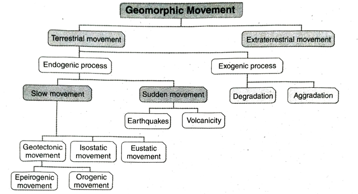
- The processes that build various new landforms and deform the shapes of landforms are called geomorphic processes or land-building processes.
- Geomorphic processes are of two types. These are- (1) terrestrial process and (2) extra-terrestrial process.
- Terrestrial processes are of two types- (1) endogenic or endogenetic process and (2) exogenic or exogenetic processes.
- Endogenic processes are further divided into two divisions- (1) diastrophic movement and (2) sudden movement.
- Diastrophic process acts slowly over a long period of time. It can be of three types- (1) geotectonic movement, (2) isostatic movement and (3) eustatic movement.
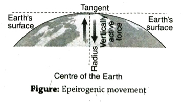
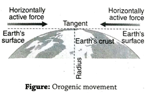
- Geotectonic movements are further subdivided into two groups- (1) Orogenic movement: This movement works almost horizontally or tangentially with the surface. (2) Epeirogenic movement: This movement works vertically with the surface or along the radius of the Earth.
- The word ‘epeirogenic’ has been derived from the Greek word ‘epeiros’ meaning continent and the word ‘orogeny’ has been derived from the Greek word ‘oros’ meaning mountain.
- The process of worldwide simultaneous change of water-holding capacity of the ocean basin due to rise or fall of the sea level is called eustatic movement.
- The tectonic process that helps to maintain elevational balance among various landforms is called isostatic movement.
- Sudden movements occur very rapidly due to sudden endogenic forces that originate within the Earth’s interior. Examples of sudden movements are volcanic eruption and earthquake.
- Processes that operate on the Earth’s surface are known as exogenetic processes. These processes are divided into three divisions- (1)degradation, (2) aggradation and (3) mass wasting.
- The process which is involved with the decrease of elevation of landforms by erosion is called degradation.
- The process which is involved with the upliftment or increase of elevation of landforms by deposition is called aggradation.
- Gradation is a process of reaching the equilibrium of altitude differences (i.e. level land) through the process of degradation and aggradation.
- Without any edium of erosion, disintegrated or loose rock materials move downward along the slope of any sloping land due to gravitational force. This process is known as mass wasting.
- Extraterrestrial materials are those which originate in outer space. When extraterrestrial materials like comets, meteors strike the Earth’s surface, it causes change in the shape of the Earth’s surface. This process is known as extraterrestrial process.
TOPIC – A
Geomorphic Process and Classification of Landforms
Long Answer Type Questions
1. Describe the different types of geomorphic movements.
Ans. Classification of geomorphic movement: The different physical phenomena and processes giving rise to various landforms and their continuous evolution and change are known as geotectonic movements or processes. They may be categorised as- 1. Terrestrial movement and 2. Extraterrestrial movement.
1. Terrestrial movement: The land building processes that take place on the Earth’s surface and in the Earth’s curst are known as terrestrial movements. Terrestrial movements are of two types- (1) Endogenic process, (2) Exogenic process.
1. Endogenic process: The slow as well as the sudden changes occurring on the Earth’s surface as a result of the force or pressure created in the Earth’s interior is known as endogenic process. It has been derived from the Greek word ‘endon’ meaning interior or inside. These processes may again be divided into two categories.
(a) slow movement or diastrophic movement, and (b) sudden movement. (a) Slow movement or diastrophic movement: The movements in the Earth’s interior, giving rise to slow movements or processes in sculpting and changing the landform features on the Earth’s surface, are slow movements or processes. They are of three types(i) Geotectonic movement, (ii) Isostatic movement and (iii) Eustatic movement.
(i) Geotectonic movement: Due to excessive pressure of the Earths crust several changes take place on the Earth’s surface. These activities are known as geotectonic movements. Geotectonic movements build various landforms on the Earth. These movements are of two types- Epeirogenic movement: The movements which are responsible for the formation of continents and oceans are called epeirogenic movements. It has been derived from the Greek word ‘epeiros’ meaning continent. These movements or processes act in a vertical manner and give rise to faults on the Earth’s surface.
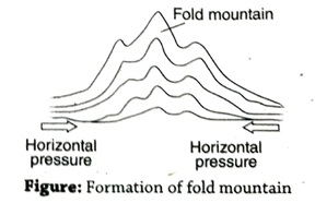
Orogenic movement: The movements which cause the folding of rocks and formation of fold mountains are called orogenic movements. It has been derived from the Greek word ‘oros’ meaning mountain. The force pressure acts in a horizontal or lateral manner in this case.
(ii) Isostatic movement: The tectonic process or movement that helps to maintain elevational balance among various landforms is called isostatic movement.
(iii) Eustatic movement: The process of worldwide simultaneous change of water-holding capacity of the ocean basin due to rise or fall of the sea level is called eustatic movement.
(b) Sudden movement: The movements take place very rapidly and all of a sudden. Earthquakes and volcanicity are caused due to such type of movements.
2. Exogenic process: The different physical features aiding in weathering and erosion and deposition, resulting in the evolution of landforms, form the exogenic process. It has been derived from the Greek word ‘exo’ meaning exterior or outside. Exogenic process are of two types-(a) Degradation and (b) Aggredation.
(a) Degradation: The process that decreases elevation of landforms by erosion is known as degradation.
(b) Aggradation: The process that is involved with the upliftment or increase of the elevation of the landform by deposition is called aggradation.
2. Extraterrestrial movement: When extraterrestrial materials like comets or meteors strike on the Earth’s surface, it causes change in the shape of the Earth’s surface. This process is known as Extraterrestrial process.
Short Explanatory Answer Type Questions
1. What is meant by landform? What are the classification of landforms according to order?
Ans. Landforms are the outer appearances on the Earth’s surface with typical geometric shapes and physical features resulting from weathering and erosion carried out by different agents like rivers (fluvial), glaciers, winds, waves.
Classification of landforms according to order: The landforms of the Earth are classified into three divisions according to order. These are . as follows-
- First order of relief: It is mainly of two types-(a) continent and (b) ocean.
- Second order of relief: It is mainly of three types-(a) mountain, (b) plateau and (c) plain.
- Third order of relief: It is mainly of two types-(a) Erosional landforms: Gorge, waterfalls, yardang, cirque, etc. (b) Depositional landforms: Delta, floodplain, etc.
2. What do you mean by slow endogenetic processes?
Ans. Slow endogenetic processes act very slowly and their effect becomes visible after thousands of years. These processes are mainly of three types-
- Geotectonic movement: New landforms are formed through the changes in different parts of the Earth’s surface by various endogenetic activities. These activities are known as geotectonic movement. They are divided into two categories- 1. epeirogenic movement, 2. orogenic movement.
- Epeirogenic movement: The movement that acts along the radius of the Earth or vertically is known as epeirogenic movement. Extensive part of the Earth’s surface either rise or sink because of the influence of these forces. The movement which occurs across the continent is called epeirogenic movement.
- Orogenic movement: In this type of movement endogenetic force acts almost horizontally or tangentially with the Earth’s surface. For this movement, there is a compressional or tensional force created on the crust. Fold mountain is formed due to orogenic movement, as it is formed by the folding of rocks on the Earth’s surface.
- Isostatic movement: The tectonic process or movement that helps to maintain elevational balance among various landforms is called isostatic movement.
- Eustatic movement: The process of worldwide simultaneous change of waterholding capacity of the ocean basin due to rise or fall of the sea level is called eustatic movement.
3. Why does the orogenic and the epeirogenic movement occur simultaneously?
Ans. The orogenic and epeirogenic movement are two different endogenetic processes but they both occur simultaneously. Compressional force that originate because of orogenic movement, causes folds in the sedimentary rock strata. As a result of this, fold mountains are formed. After this due to excessive compressional force, a fracture or fault occures in the fold. Along this fault line, extensive part of the surface may rise or subside. Such vertical upliftment or subsidence of the surface is called epeirogenic movement.
If a fracture or fault originate in the rock strata due to epeirogenic movement, lateral pressure causes folds on the adjacent rock strata i.e., orogenic movement occurs. In this way, orogenic and epeirogenic movement occur simultaneously.
Example: Himalaya is a fold mountain; both folds and faults are seen in this mountain.
4. Find out the interrelation among degradation, aggradation and gradation.
Ans. Degradation, aggradation and gradation are different types of exogenetic processes. Degradation process is mainly related to erosion. Several exogenetic forces like rivers, winds, glacier, sea-waves, etc. cause erosion and reduce elevation of land. This process is known as degradation process. The material eroded by various external forces is deposited in the depression or lowlands and that cause rise in elevation. This process is called aggradation. Gradation is the process of attaining equilibrium by removing unevenness of land by the combination of degradation and aggradation processes. It is clear that gradation process is result of simultaneous degradation and aggradation processes.
5. ‘Degradation and aggradation are opposite processes. Explain the causes.
Ans. Degradation is related to the reduction of the elevation of the landform. Elevation of the land surface gradually decreases due to the process of erosion and denudation. This process is also called deductive process.
On the other hand, eroded materials are transported by several natural agents and deposited in the lowlands. Thus, the elevation of these lowlands gradually increases. This process of upliftment of the landform is called inductive process.
So, degradation is the process of lowering of the land surface by erosion and aggradation is the process of upliftment of land surface by deposition. Therefore, degradation and aggradation are opposite processes.
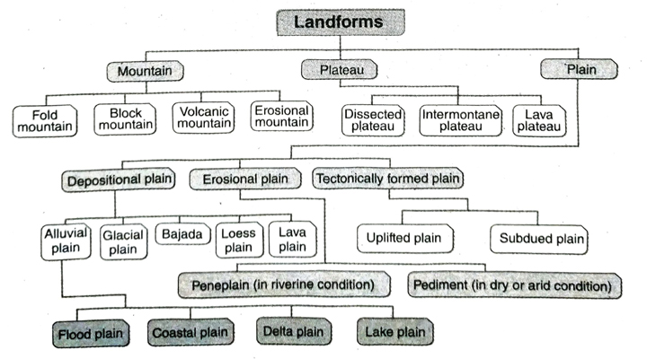
6. Classify the different types of landforms.
Ans. Landforms are the outer appearances on the Earth’s surface with typical geometric shapes and physical features resulting from weathering and erosion carried out by different agents like rivers (fluvial), glaciers, winds, waves, etc.
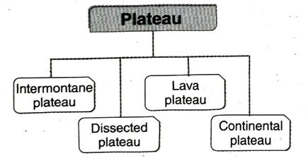
Usually, based on the height, shape, structure, slope and undulations of the land, landforms can be classified into 3 major divisions- (1) mountains, (2) plateaus, and (3) plains. These can again be subdivided into further classes as shown in the chart.
Short Answer Type Questions
1. What are landforms? What are the major landforms on the Earth’s surface?
Ans. Landforms are the outer appearances on the Earth’s surface with typical geometric shapes and physical features resulting from weathering and erosion carried out by different agents like rivers (fluvial), glaciers, wind, waves.
The major landforms on the Earth’s surface are mountains, plateaus and plains. Notable examples in India are the Himalayas, the Deccan Plateau and the Indo-Gangetic Plain respectively.
2. What are geotectonic activities?
Ans. The tectonic disturbances/activities originating under the Earth’s crust (in the interior) that lead to the formation of primary relief features or landforms on the Earth’s surface are known as geotectonic activities. These are of two types- (1) epeirogenic and (2) orogenic movements.
3. What is meant by geocentric or endogenic process?
Ans. The initial process whereby the landforms are formed (relief of the 1st order) is known as geocentric or endogenic process. For example, geotectonic activity, volcanicity, plate movement occur suddenly in the Earth’s interior and have their influence on the landforms of the Earth’s crust.
4. What is exogenic or exterior process?
Ans. The different forces of nature or agents of erosion which act on the Earth’s outer surface are called exogenic or exterior processes. For example, weathering and erosion. Since they are acting continuously over a long period of time, they play a major role in forming different types of landform on the Earth’s crust.
5. What is meant by geotectonic disturbance or diastrophism?
Ans. When any part of the Earth’s surface is uplifted or subsides as a result of tectonic activity, it is called a geotectonic disturbance. This happens as a result of tectonic disturbance and isostatic or eustatic disturbance. Epeirogenic and orogenic (mountain-building movement) movements cause changes in the landforms on the Earth’s surface.
6. What are epeirogenic movements?
Ans. The vertical movements on the Earth’s crust due to tectonic activities in the Earth’s interior are known as epeirogenic movement. Faults are created on the Earth’s crust and certain parts of it either move up or down as a result of such movements.
7. What are orogenic movements?
Ans. The horizontal movements on the Earth’s crust due to tectonic activities in the Earth’s interior are known as orogenic movements. They are also called mountain-building movements. Fold mountains are formed and the crust is deformed due to such movements. The Himalayan-Alpine orogeny is a classic example of this.
8. What is meant by isostatic imbalance?
Ans. The different landforms (like mountains, plateaus and plains) exist on the Earth’s surface while maintaining a certain balance among each other, known as isostatic balance (since the Earth’s solid crust floats on the viscous mantle below it). If this balance is disturbed due to some reason, the movement that follows is known as isostatic imbalance.
9. What is the eustatic movement?
Ans. The process of worldwide simultaneous change of water-holding capacity of the ocean basin due to rise or fall of the sea level is called eustatic movement.
Multiple Choice Type Questions [MCQ type]
Write the correct answer from the given alternatives
1. Rivers are responsible for the change of landforms in-
A. glacial regions
B. wet and humid areas below the snowline
C. desert areas
D. none of these
Ans. B
2. Change in the structure of landforms requires-
A. geotectonic activity
B. denudation
C. geotectonic activity and denudation
D. none of these
Ans. C
3. Geotectonic activity takes place in-
A. lithosphere
B. thermosphere
C. mesosphere
D. asthenosphere
Ans. D
4. The meeting point of mountain ranges is called-
A. mountain range
B. mountain peak
C. mountain knot
D. none of these
Ans. C
5. ‘Tail’ is formed as a result of-
A. depositional work of rivers
B. deposition of mud and pebbles by a glacier
C. sand deposition in coastal areas
D. wind erosion
Ans. B
6. The landform that form due to the orogenic movement is-
A. residual mountain
B. depositional mountain
C. block mountain
D. folded mountain
Ans. D
7. Suitable example of external processes is-
A. river erosion
B. tectonic movement
C. Earthquake
D. volcanism
Ans. A
8. Meaning of greek word ‘epeiros’ is-
A. continent
B. ocean
C. mountain
D. plateau
Ans. A
9. Orogenic movement is-
A. slow endogenetic process
B. external process
C. sudden endogenetic process
D. extra-terrestrial process
Ans. A
Very Short Answer Type Questions
Fill in the blanks with suitable words
1. The term ‘geotectonic’ has been derived from the Greek word ……… which means built up.
Ans. tecton
2. Epeirogenic movement is a type of ………. movement.
Ans. vertical
3. ………. mountain is formed due to the effect of orogenic movement.
Ans. Folded
4. Degradation processes are involved with the ……….. of elevation due to erosion.
Ans. decrease
5. ………. processes are involved with the increase of height due to deposition.
Ans. Aggradation
If the statement is true, write T and if false, write ‘F’ against the following
1. Orogenic activity occurs parallel to tangential point of the Earth.
Ans. T
2. Epeirogenic movement takes place parallel to the tangential point of the Earth.
Ans. F
3. Endogenetic processes mainly occur slowly.
Ans. T
4. The word ‘orogeny’ has derived from the latin word ‘oros’.
Ans. F
TOPIC – B
Mountains
Long Answer Type Questions
1. Define mountains. What are the classifications of mountains?
Ans. Mountains: Rocky regions extending over vast areas, with an average height of over 1,000 metre above sea level and having peaks are called mountains. For example, the Himalayas, Vindhyas and Satpura mountain ranges in India.
Classification of mountains: Mountains can by broadly classified into 4 types-
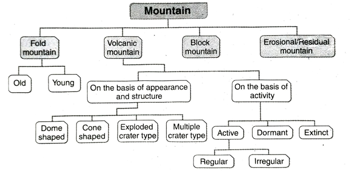
- Fold mountains: When the sediments on the ocean floor are subjected to lateral pressure due to tectonic movements, they are compressed, folded and forced to rise up and form fold mountains. The higher convex parts of these mountains are called anticlines and the lower concave parts are called synclines. On the basis of origin, fold mountains are mainly of two types-
- Old or ancient fold mountains: Examples of such mountains are the Aravallis in India, Appalachian mountain ranges of United States of America, etc.
- Young fold mountains: Examples of such mountains are the Himalayas in India, Alps in Europe and the Rocky Mountains in North America.
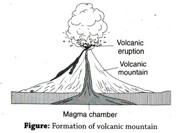
- Volcanic mountains: When molten magma comes out from the Earth’s interior through cracks and fissures, and after cooling down accumulates to great heights, they form volcanic mountains. They are also called depositional mountains. For example, Fujiyama in Japan and Mt. Vesuvius in Italy, etc.
On the basis of their appearance and structure, different types of volcanic mountains, like conical, dome-shaped etc., have formed all over the world. Again, on the basis of the kind and frequency of volcanic activity, such mountains can be classified as extinct, dormant and active volcanoes.
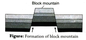
- Block mountains: When any part of the Earth’s surface is forced upwards between two faults on either sides of it, they form flat-topped block mountains or horsts. For example, the Black Forest and Vosges rise much above their adjacent Rhine valley. The Satpuras in India is another example of block mountain.
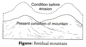
- Erosional residual mountain: When any fold mountain, block mountain or upland area is reduced in elevation due to weathering and erosion by various agents such as rivers, wind, glaciers over a long time, it forms erosional or residual mountains. For example, the Aravallis in India and Henry Mountains in North America.
2. Discuss the formation of fold mountains in relation to Plate Tectonic Theory.
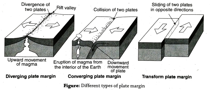
Ans. Formation of fold mountains: The Plate Tectonic Theory was first propagated by a French scientist Xavier Le Pichon in 1968. The main idea behind this theory is that the Earth’s crust is made up of a number of large plates which are on an average about 100 km in depth and each of them extend over lakhs of kilometre. The plates comprising the continents are called continental plates and those of the ocean floors are called oceanic plates. These solid crustal plates are floating on the mantle which is in a viscous state. Due to the convection currents circulating in the mantle and other tectonic movements that these plates move continuously. As a result, in the plate margin areas, various landforms have formed. Usually there are 3 types of plate margins-
- Converging plate margin: The plates move towards each other along this plate margin. This plate margin is also known as destructive plate margin.
- Diverging plate margin: The plates move away from each other along this plate margin. This plate margin is also known as constructive plate margin.
- Transform plate margin: The adjacent plates move along each other in a parallel manner (but in opposite directions) along this plate margin.
Formation of fold mountain in converging plate boundary: Converging plate margins are mainly of 3 types-
- Continental-Continental plate margin: When two continental plates move towards each other, it is called continentalcontinental plate margin.
- Continental-Oceanic plate margin: When one continental and one oceanic plate Imove towards each other, it is called continental-oceanic plate margin.
- Oceanic-Oceanic plate margin: When two oceanic plates move towards each other, it is called oceanic-oceanic plate margin.
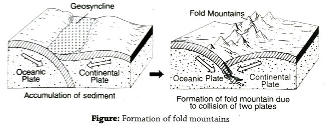
Out of these three types, the first two plate margin movements are responsible for the formation of fold mountains. The process of formation of fold mountains are as follows-
- Continental-Continental plate margin: A narrow and shallow seabed lying between two is continental plates called geosyncline. Rivers and streams from both the adjoining continents deposit their silt on this seabed and gradually fill it up. As the converging continental plates come closer, the geosyncline narrows down and the intervening sediments come under great pressure resulting in crumpling up and folding of these sediments in the geosyncline. This is how fold mountains are formed. For example, when the Indian Plate and the Eurasian Plate moved towards each other, the sediment of the Tethys Sea lying in between was subjected to pressure from both sides and was forced to crumple and rise to form folds, resulting in the formation of the Himalayan mountain ranges.
- Continental-Oceanic plate margin: When the continental and oceanic plates approach each other, the heavier oceanic plate subsides below the lighter continental plate in a downward bend (like a bow) along the plate margin. This zone is called subduction zone or Benioff Zone. Consequently, as the two plates come nearer to each other, the lateral or horizontal pressure exerted is so much that the sediments deposited in the plate margin are crumpled up and they rise upwards, resulting in the formation of fold mountains. For example, the Rocky Mountains have been formed as a result of folding of the sediments along the margin of the American Plate (continental plate) and Pacific Plate (oceanic plate).
3. Describe the different stages of formation of fold mountains.
Ans. Different stages of formation of fold, mountain: According to geologists, many fold mountains were formed throughout the world, known as ancient or old fold mountains, before the formation of the young fold mountains of recent geological age like the Himalayas and the Alps. The fold mountains were formed basically in three stages and there was an intervening break or inactive period between two such stages. These stages were
- Silurian and Devonian Period: According to geological time scale, it was some time in the mid-Paleozoic era, i.e., between the Silurian and Devonian sub-periods (37.2 million to 44.5 million years ago) that the Atlantic Ocean was compressed as a result of the two converging plates of America and Europe. The mountain created as a result of folding is known as the Caledonian Fold Mountains. It is as a result of this that fold mountains have also developed in northern Ireland, Scotland and Scandinavian islands. After this, there was a period of lull when no activity took place.
- Carboniferous Period: At the end of the Paleozoic era in the sub-period of Carboniferous and Permean (29 to 35 million years ago), the Altyde (Hercynian) fold mountains were developed as a result of crumpling up of sediments. The American and Hercynian mountains located in the southern part of Caledonian Fold Mountains in Europe and the Appalachian Mountains in North America were formed during this period. The Ural Mountains in Russia and Tien Shan and Nan Shan mountains in Asia were also formed during this time.
- Tertiary Period: Folds also developed during the Tertiary period (2 million to 6.6 million years ago) after the Altyde orogeny (mountain-building era). As a result, new mountain ranges were formed in the southern part of Altyde mountain ranges and these are called Alpine orogeny. The Alps, Himalayas, Rockies and Andes mountain ranges were all formed during this period. The old fold mountain ranges are now reduced to lower heights as a result of erosion by different physical factors over a long time. They have now turned into low and dissected erosional plateaus. For example, the Caledonian range in Europe.
4. What is mountain? Describe the characteristics of fold mountains.
Ans. Mountain: When the sediments on the ocean floor are subjected to lateral pressure due to tectonic movements, they are compressed, folded and forced to rise up and form fold mountains.
Characteristics of fold mountains:
Characteristics of fold mountains are as follows:
- Significance of nomenclature: Since the mountains form as a result of folding and rising up of sedimentary rocks, they are called fold mountains.
- Required force: Fold mountains form as a result of tectonic force (orogeny or mountain-building movements).
- Main components: The two main parts of fold mountains are anticlines and synclines.
- Predominant rocks: Though the major components of fold mountains are sedimentary rocks, igneous and metamorphic rocks are also found locally.
- Area of extension: Fold mountains are lofty and extend over wide areas. For example, the Himalayas are 8,848 m above sea level and extend over the whole of northern part of India (from west to east).
- Presence of fossils: Being formed of sedimentary rocks (usually in oceanic environment), they have remains of plants and animals embedded in the rock layers known as fossils.
- Multiple peaks: Fold mountains have multiple peaks. For example, Mt. Everest, Makalu, Phalut, Kangchenjunga, etc., are the famous peaks of the Himalayas.
- Other characteristics: (1) Fold mountain areas are prone to earthquakes. (2) The plate movements, being a continuous activity, gradually lead to the increase in height of these mountains. (3) They have steep slopes. (4) They are conical in shape. (5) They are distinguished by the undulations (ups and downs) in their relief features and are sometimes inaccessible.
5. Explain the formation of volcanic mountains. Mention the characteristics of volcanic mountains.
Ans. Origin of volcanic mountains: When the hot molten magma comes out to the Earth’s surface through cracks and fissures in the Earth’s crust, it cools down and accumulates, thereby gaining height and forming mountains, they are called volcanic mountains. Mt. Fujiyama in Japan, Mt. Vesuvius in Italy, etc., are examples of such mountains. Their formation can easily be related to the Plate Tectonic theory.
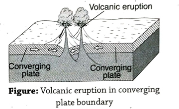
- Converging plate margins: When two converging plates approach each other, the margin between them is called converging plate margin. When they collide, the relatively heavier plate sinks below the lighter plate. When it reaches the mantle, it becomes hot and melts. Subsequently, this hot molten magma is forced up through the cracks and fissures and it comes out to the Earth’s surface (through volcanic activity). In due course of time, this lava cools down, accumulates, and rises up to form volcanic mountains.
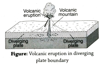
- Diverging plate margins: When two plates move away from each other in opposite directions, they are called diverging plates. From the gap created as a result of this movement, hot molten magma comes out and eventually fills it up, forming volcanic mountains here.
- Hotspot: In some cases, magma comes out through the hotspots (i.e., centres of radioactivity). The upward movement of this magma is facilitated by the upward moving convection currents generated in the mantle below the Earth’s crust. Examples of such volcanic mountains areMt. Fujiyama in Japan, Mt. Vesuvius in Italy, Barren Islands in India. These mountains become increasingly high as a result of further volcanic activity and accumulation of lava in those regions.
Characteristics of volcanic mountains:
The characteristics of volcanic mountains are-
- Shape: Volcanic mountains are usually triangular or conical in shape.
- Presence of crater: A volcanic mountain has one or more than one crater at its top.
- Connected to the magma chamber: The volcanic mountain is connected to the magma chamber in the Earth’s interior through a tube-like structure (called the ‘vent’).
- Slope: Volcanic mountains usually have steep slopes.
- Altitude: They are moderate in altitude. However, their altitude increases with subsequent volcanic activity and accumulation of more lava on its top.
- Structure: Volcanic mountains usually form in unstable parts of the Earth, for example, along the moving plate marging.
- Rocks: Volcanic mountains are usually formed of acidic and alkaline igneous rocks.
- Settlements: Being usually inaccessible, with cold climate due to high altitude and lack of fertile soil, volcanic mountain areas are usually devoid of or have scattered settlements.
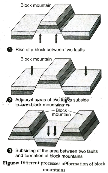
6. Explain the formation of block mountains. Mention some of their characteristics.
Ans. Formation of block mountains: When any part of the Earth’s surface is uplifted along fault lines due to epeirogenic movements, they assume the appearance of a mountain known as block mountain. They are flat-topped and rise above the surrounding areas. For example, the Satpura mountains in India.
Block mountains are formed mainly due to the following three reasons-
(1) The intervening land between two fault lines are forced to rise upwards to form a block mountain. (2) When the two blocks along two fault lines subside below the Earth’s surface, the intervening block takes the shape of a block mountain. (3) When the land between two fault lines subsides, the areas on its two sides stand out as two block mountains.
Characteristics of block mountains:
Some important characteristics of block mountains are-
- Time taken for formation: The formation of a block mountain takes place all of a sudden.
- Altitude: Block mountains are lower in height compared to fold mountains.
- Summit: The top portion or summit of block mountains are flat.
- Slope of the land: They have steep slopes on all sides.
- Rift Valley/Graben: Block mountains or horsts have rift valleys or grabens lying adjacent to them.
- Extent: Block mountains are not as widespread the fold mountains.
- Rocks: Block mountains are made up of sedimentary and metamorphic rocks.
- Tectonic movement: Block mountains are formed as a result of epeirogenic movement.
7. Explain the formation of erosional mountains. Mention their characteristics.
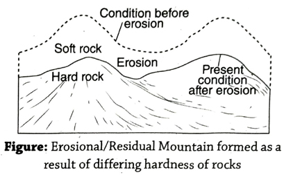
Ans. Formation of erosional mountains: When one or more of the characteristic features of a mountain is seen in an eroded mountain or upland (being eroded by rivers, glaciers, winds, sea waves, etc.), they are called erosional or residual mountains. For example, the Aravalli Hills in India (actually is an ancient fold mountain). This type of mountain is formed in two ways-
- Differential texture (hardness) of rocks: Any high mountain, hill or upland is made up of both hard and soft rocks. The soft rocks, being weaker and more prone to erosion, are easily eroded and reduce in altitude, while the hard and resistant rocks stand out as mountains and hills. The Aravalli Hills in India are examples of this type.
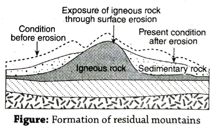
- Volcanic activity or intrusion in the sedimentary rocks: When, due to volcanic activity or diastrophism, igneous rocks are intruded upon especially vertically (as dykes), this molten magma gradually cools down to form igneous rocks within the sedimentary rock layers. In due course of time, when the upper sedimentary rock layers are eroded, these igneous rocks are exposed to the surface. Since they are hard and resistant rocks, they form residual mountains. For example, the Henry Mountain in North America.
Characteristics of erosional mountains: The main characteristics of erosional mountains are-
- Origin: Forms as a result of erosional process over a long time by different agents of erosion like rivers, glaciers, winds, etc.
- Altitude: Erosional mountains are usually low in height and since they are in a continuous process of erosion, they gradually decrease in elevation.
- Summit: The summit or top of erosional mountains are rounded since they have been eroded.
- Rocks: They are usually made up of hard igneous and metamorphic rocks.
- Slope: The slopes of erosional mountains are not steep.
- Ruggedness: The ruggedness of these mountains is quite high.
- Age: Erosional mountains are geologically quite old.
8. Discuss the importance of mountains with examples.
Ans. Importance of mountains: The importance of mountains are as follows-
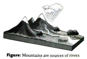
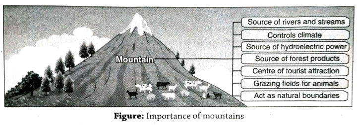
- Source of rivers and streams: Many small streams and big rivers have their origin in the meltwaters of the snow-capped mountains. These rivers have great influence on human life and civilisation. For example, the big rivers like the Indus, Ganges, Yamuna, Teesta, etc., have their sources in the snow-capped peaks of the Himalayas.
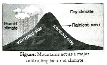
- Controls climate: (1) Being very high, the upper reaches of mountains have cold climate and snowfall is common here. (2) The windward side of the mountain act as a climatic barrier to the moisture bearing winds and orographic or relief rainfall occurs here, while on the opposite side there is no rainfall. (3) A mountain controls the direction of winds too. For example, the Himalayas prevent the cold Siberian winds from entering India.
- Source of hydroelectric power: The snowfed rivers of the mountainous regions are perennial and have water throughout the year. The streams having strong water currents are also ideal for producing hydroelectricity.
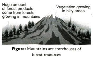
- Source of forest products: The dense forests in the mountainous regions are sources of valuable timber, honey, medicinal plants, fruits, etc. Due to the ruggedness of the terrain, the mountainous regions are sparsely populated.
- Centre of tourist attraction: Snowfields, waterfalls, springs, swift-flowing streams and rivers, valleys, ridges, gardens with beautiful fruits, flowers and orchids appeal to the eyes of many tourists who love to visit these mountainous areas, making them areas of major tourist attraction. For example, Simla, Kashmir (valley), Darjeeling, Gangtok, etc., in the Himalayas are popular tourist spots.
- Grazing fields for animals: Grazing animals on the green pastures of mountain slopes are the major activities of nomadic tribes of mountainous regions. For example, the Gujjars and Goddi tribes of Kashmir.
- Act as natural boundaries: The lofty mountains act as barrier to the intruders from neighbouring countries who try to enter illegally.
- Other importance: (1) Mountains are ideal places for mountain climbers and trekkers. (2) Fossils which are found embedded in the sedimentary rocks of mountains provide important clues to ancient life. (3) The origin of mountains are quite significant to geologists and geographers who are involved in research work. (4) The different environments associated with varying landforms, climate, soil and natural vegetation of mountains have greatly influenced man’s adaptation to nature. (5) Civilisation and culture are also influenced by different environments in mountainous areas.
Short Explanatory Answer Type Questions
1. What are the influences of mountains on human life?
Ans.Mountains play a vital role in human life. Some of these are- (1) Dense forests provide rich resources in high mountainous regions. (2) Hydroelectricity is generated from swiftflowing mountain rivers. (3) High mountains act as a climatic barrier and play a major role in controlling the climate of any region, including temperature (by preventing cold winds from entering the country) and rainfall (by causing relief or orographic rainfall on the windward side of a mountain). A glaring example of this is the Himalayas influencing the climate of India. (4) Lumbering, animal husbandry and livestock rearing, tourism, etc., flourish in mountainous regions though agriculture is not possible here due to the rough terrain (except in case of terrace farming on mountain slopes). (5) Population is sparse in these areas as steep slopes and rocky terrain make construction of roads difficult. Lack of accessibility hampers the growth of big settlements in these mountainous regions.
2. Classify volcanic mountains based on the nature of volcanic activity. Give examples.
Ans. Volcanic mountains can be classified into three majors categories based on the nature of volcanic activity. It is shown in the following table-
| Types |
Characteristics |
Sub-types |
Examples |
| 1. Active |
These are volcanic mountains which exhibit frequent eruptions. |
1. Constant or uninterrupted volcano (where there is continuous volcanic activity).
2 Interrupted volcano (where volcanic eruptions take place at intervals).
|
1. Mt. Vesuvius in Italy
2 Mt. Stromboli in Italy and Barren Island in India
|
| 2. Dormant |
These are volcanic mountains which have not erupted over a long period, but can erupt in future. |
|
Mt. Fujiyama in Japan, Mt. Popocatepetl in Mexico, Mt. Narcondam in Andaman and Nicobar. |
| 3. Extinct |
These are volcanic mountains which erupted long ago and there is no chance of eruption in the future. |
|
Mt. Popa in Myanmar |
3. Why are fossils found in fold mountains?
Ans. The sediments deposited under the sea have remains of dead plants and animals embedded within their layers. When these sediments are pressurised, they eventually transform into rocks. Later on, these sedimentary rocks are prone to horizontal pressure from either side and they crumble up and form fold mountains. Thus the fold mountains composed of such sedimentary rocks have fossils embedded in them.
4. Why are volcanic or igneous matter found in fold mountain regions?
Ans. The front portion of the heavier oceanic plate slides under the lighter continental plate at about 30°-80° angular plane. As a result, the sediments in this colliding zone buckle up under pressure and form fold mountains. At the same time, the portion of the solid oceanic plate which goes beneath to reach the mantle, is heated up and melts. This molten magma comes up to the Earth’s crust in this subduction zone, where fold mountains are in the process of formation. This is the reason why volcanic or igneous matter is found here.
5. What are the features of erosional or residual mountains?
Ans. Following are the features of erosional/ residual mountains- (1) The extent of this type of mountain is limited, (2) they are low in height, (3) they have gentle slopes since erosion takes place over a long period of time, (4) the mountain tops are rounded or dome-shaped, (5) these mountains are made up of all three types of rocks, they are made up of hard and resistant ancient rocks.
6. What is Benioff Zone?
Ans. As a result of the horizontal movement of two plates, when the heavier plate subsides or goes under the lighter plate, that area or zone is called the subduction zone or Benioff Zone. This zone has been named after the scientist Benioff.
Characteristics: Melting down of solid plates (comprising the Earth’s crust), convection currents in the magma (present in the mantle), earthquakes and volcanicity are all common features of this zone.
Example: As a result of the horizontal movement of the Eurasian plate towards the Pacific Oceanic Plate, the heavier Pacific Oceanic Plate has gone under the Eurasian continental plate and formed a Benioff Zone here.
7. What is the ‘Pacific Ring of Fire’?
Ans. The majority of the world’s volcanoes are situated around the Pacific Ocean. Out of these, about 500 active volcanoes (about 70 percent of the world’s volcanoes) are situated all around the Pacific Ocean like a ring. When these volcanoes erupt (quite frequently) it seems to resemble a ring of fire. This circular belt of volcanoes extend from South America’s Cape Horn to the Andes mountains, via the Rocky Mountains of North America and then extend to the west through the Aleutian Islands, Kamchatka Peninsula, Japan and Philippines.
8. Why are volcanic mountain regions prone to earthquakes?
Ans. Earthquakes are common in volcanic mountainous regions because- (1) When volcanic mountains are formed along the margins of converging or destructive plates, two plates collide and this results in the occurrence of earthquakes. (2) When hot and molten magma comes out from the asthenosphere or mantle in the gap created by two diverging plates, earthquakes may occur due to its pressure. (3) When volcanic mountains are formed in the hotspot zones, magma, gases, etc., come out from the interior of the Earth towards the Earth’s surface. The resulting upward force and pressure make these areas prone to earthquakes.
9. Why are erosional mountains also known as residual mountains?
Ans. The landforms are sculpted and altered over a long period of time under the influence of different physical factors which cause weathering and erosion. Due to this, the higher mountainous areas formed of relatively weaker and softer rocks are eroded and reduced to mountains with lower altitudes. On the other hand, the harder resistant rocks of the mountains are less eroded and stand out as smaller mountains or uplands. The mountains which are reduced by erosion to lower levels or heights are therefore known as erosional or residual mountains or hills. The ancient mountains like the Aravallis in India, Appalachians in North America are the type of mountains which have been reduced in height due to erosion over the ages.
10. Write the characteristics of fold mountain.
Ans. The characteristics of fold mountains are as follows-
- Fold: Fold mountains have been formed due to the folding of sedimentary rock strata over extensive area.
- Anticline and syncline: The folds are formed as a result of the combination of anticline and syncline.
- Fault: Besides the presence of folds, there are also many faults in fold mountains.
- Rock: Fold mountains are mainly composed of sedimentary rocks. But in many places, sedimentary rocks are transformed into metamorphic rocks due to intense heat and pressure. Also, in some places, igneous rocks are also found due to intrusion of magma through the fault or cracks.
- Fossils: Fossils are found inside the rock strata of a fold mountain.
- Other characteristics: (1) Young fold mountains are generally earthquake-prone. (2) Elevation of fold mountains gradually increases due to the plate movement. (3) Most of the mountains are very high with deep gorges and steep slopes. (4) Most peaks of fold mountains are conical. (5) Fold mountains occupy extensive areas.
Short Answer Type Questions
1. What is asthenosphere?
Ans. The denser, weaker layer beneath the lithospheric mantle is known as asthenosphere. The plates float over this layer. This zone lies upto the depth of 200 km beneath the Earth’s surface. The temperature and pressure of the asthenosphere is very high. So the rocks melt partly and become molten in nature.
2. What is mountain?
Ans. A extensive area of the Earth’s surface that rises over 1000m above sea level with rocky terrain is called as a mountain. E.g. the Himalayas.
3. What is a mountain peak?
Ans. The high conical top of a mountain is called its peak. For example, Mt. Everest (8,848 m above sea level) is the highest peak of the Himalayas. A mountain may have several peaks.
4. What are fold mountains?
Ans. When the sediments of the ocean floor come under pressure and are crumpled up due to orogenic movement, they are uplifted to form fold mountains (having peaks). For example, the Himalayas, the Rockies, the Andes, the Alps, etc.
5. What are anticlines and synclines?
Ans. The upper parts of a fold mountain are called anticlines and the lower parts (valleys) are called synclines.
6. What are ancient/old and young fold mountains?
Ans. The fold mountains which are very old according to geological age have been affected by erosion over millenia and, as a result, their heights have decreased. For example, the Aravalli in India. On the other hand, the young fold mountains have formed much later according to geological age and they are higher than the old fold mountains. For example, the lofty Himalayas.
7. What is plate margin?
Ans. Large parts of the Earth’s crust which are constantly moving and constitute the continent and ocean floors are called plates. The margin or border of two such plates is called plate margin.
8. What are the different types of plate margins?
Ans. There are mainly 3 types of plate margins- (1) converging or destructive plate margins (plates moving towards each other), (2) diverging or constructive plate margins (plates moving away from each other) (3) transform or conservative or parallel plate margins (plates moving or sliding along each other, but in opposite directions) and are neither destructive nor constructive in nature.
9. What are suture lines?
Ans. The margin where two continental plates meet and join each other is known as a suture line. Fold mountains are formed along such lines and the mountains gradually increase in height with further lateral pressure exerted by the plate movements (moving towards each other).
10. What is a geosyncline?
Ans. The long and narrow portions of the sea floor where there is continuous deposition of sediments (such as silt, sand, pebbles) are called geosynclines. Due to lateral/ horizontal pressure coming from both sides, the sediments are crumpled up and form fold mountains. For example, the young fold mountains of the Himalayas have formed in such a geosyncline (called the Tethys Sea).
11. Why is a convergent plate margin known as a destructive plate margin?
Ans. When two tectonic plates move towards each other, the margin or margin is called convergent plate margin. If a heavier plate (viz., an oceanic plate made up of sima) slides under a lighter plate (víz., a continental plate made up of sial), the sediments on its margins get crumpled up and give rise to fold mountains. Parts of the heavier plate may subside and enter the semi-molten magma below where the solid part of the plate (crust) is melted down and lost. These areas are also prone to earthquakes. This is the reason why they are known as destructive plates.
12. What is the Tethys Sea?
Ans. According to geologists, from the later part of the Carboniferous Period till the early part of the Cretaceous Period, the Tethys Sea was located in between Gondwanaland to the south and Laurasia or Angaraland to the north. Later on, the sediments deposited in the bed of sea gave rise to the formation of the Himalayas (a young fold mountain range) as a result of plate movements.
13. What is crater?
Ans. Crater is a bow-shaped depression or hole at the top of a volcanic mountain from which lava, gases, ash and solid materials come out at the time of volcanic eruption. For example, there are multiple craters in the Fujiyama Volcano of Japan.
14. What is plume?
Ans. In certain places in the mantle, temperature remains quite high due to the presence of radioactive materials and convectional current. These are called hotspots. Due to excessive heat, an upwelling current of magma originates from these hotspot which is known as plume. Sometimes, over these plumes, volcanoes are located on the Earth’s surface. For example-Tibesti Mountain of Central Sahara is located as a volcano over such a plume.
15. What is a caldera?
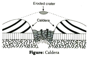
Ans. The opening through which volcanic ash, lava, and gases gush out during a volcanic eruption is called a crater. A large-sized opening is called a caldera. Sometimes a crater may collapse and subside to from a caldera.
16. What is meant by a hotspot?
Ans. Parts of some weak or thin plates lying in the central part of the plates become very hot as a result of radioactivity taking place there. Later on, as a result of uprising convection currents, magma may force its way upwards and this lava may form volcanic mountains. There are about 25 such hotspots all over the Earth’s surface.
17. What are erosional mountains?
Ans. When high and extensive rocky landmasses are subjected to erosion by various forces of nature (like weathering, river, wind), the residual/remaining part of such mountains are called erosional or residual mountains. They are much lower in height but retain the features of a mountain. For example, the Aravalli Hills in India.
18. What is a depositional or aggradational hill?
Ans. Molten magma comes out from beneath the Earth’s surface through cracks and fissures, as a result of tectonic movement. Over time, layers of magma accumulate over each other, forming a hill. For example, Mt. Fujiyama of Japan.
19. What is fault?
Ans. Due to the alternative processes of expansion and contraction occurring during epeirogenic movements, cracks are formed on the rock layers of the Earth. If the adjacent rock layers separate along these almost vertical cracks and get displaced, they give rise to faults.
20. What are block mountains or horst?
Ans. When a block of landmass is uplifted along a fault as a result of epeirogenic movement, it forms a flat-topped hill called block mountain. For example, the Satpura Hill of India, Vosges of France, Black Forest of Germany.
21. What is a rift valley or graben?
Ans. When a block of landmass subsides along two faults as a result of epeirogenic movements, this subsided block is called a rift valley or graben. For example, the Narmada river of India, lying adjacent to the Satpura hills, and the Rhine river valley of Germany, which lies between the Vosges and Black Forest block mountains.
22. What are the ‘Pillars of Light’, located in the Mediterranean Sea?
Ans. In the Lipari Island of Italy in the Mediterranean Sea, frequent volcanic eruptions occur from the volcanic mountain known as Stromboli. This light can be seen from great distances during the night. The sailors of the ships during ancient times plying on the Mediterranean Sea used to determine their direction with reference to these lights. Thus, they are known as ‘Pillars of Light’.
Multiple Choice Type Questions [MCQ type]
Write the correct answer from the given alternatives
1. An example of an ancient mountain range is the-
A. Rockies
B. Alps
C. Aravallis
D. Himalayas
Ans. C
2. An example of a block mountain is the-
A. Himalaya
B. Satpura
C. Vesuvius
D. Rocky
Ans. B
3. An example of a volcanic mountain is the-
A. Fujiyama
B. Satpura
C. Eastern Ghats
D. Andes
Ans. A
4. A shallow and narrow seabed is known as-
A geosyncline
B. continental shelf
C. continental slope
D. continental drift
Ans. A
5. An example of rift valley in India is-
A. Ganga valley
B. Narmada valley
C. Indus valley
D. Kaveri valley
Ans. B
6. The folding of rock beds leads to the formation of-
A. fold mountains
B. block mountains
C. volcanic mountains
D. depositional/aggradational mountains
Ans. A
7. The highest mountain peak in India is-
A. Mt. Everest
B. Mt. Godwin Austen or K2
C. Mt. Kangchenjunga
D. Mt. Phalut.
Ans. B
8. Another name for volcanic mountain is-
A. degraded/erosional mountain
B. fold mountain
C. aggraded/depositional mountain
D. residual mountain
Ans. C
9. Germany’s Black Forest is actually a-
A. forest
B. block mountain
C. black soil region
D. cold desert
Ans. B
10. Mt. Everest is located in-
A. Nepal
B. Bhutan
C. India
D. China
Ans. A
11. The main propounder of the Plate Tectonic Theory is-
A. McKenzie
B. Pichon
C. Wilson
D. Darwin
Ans. B
12. Plate margins are usually of-
A. 1 type
B. 2 types
C. 3 types
D. 4 types
Ans. C
13. The longest fold mountain range in the world is the-
A. Himalayas
B. Rockies
C. Alps
D. Andes
Ans. D
14. Converging plate movements result in the formation of-
A. block mountains
B. fold mountains
C. erosional or residual mountains
D. plains
Ans. B
15. A fold mountain range located in India is the-
A. Western Ghats
B. Eastern Ghats
C. Satpuras Range
D. Himalayan Range
Ans. D
Very Short Answer Type Questions
Fill in the blanks with suitable words
1. ……… is the viscous layer of magma formed in upper mantle of the Earth.
Ans. Asthenosphere
2. Fault which is created along or a line on the Earth’s crust is called……..
Ans. fault line
3. Mt. Vesuvius is a(n) ……… volcano.
Ans. live or active
4. Plains have a ……… population density.
Ans. high
5. Fujiyama is a …….. crater type of volcano.
Ans. multiple
6. Most of the world’s volcanoes are located in the ‘…….. Ring of Fire’.
Ans. Pacific
7. Fossils are mostly found in the rocks of ……… mountains.
Ans. fold
8. An erosional mountain in India is……….
Ans. Aravalli
9. The Himalayas have been formed in the ……… geosyncline.
Ans. Tethys
10. Folds are seen only in ……… mountains.
Ans. fold
TOPIC – C
Plateaus
Long Answer Type Questions
1. What is meant by a plateau? Classify plateaus.
Ans. Plateau: A table-like landform which is usually more than 300 metre above sea level, almost flat on the top with steep slopes, is called plateau. This is also called tableland. Sometimes low hills are found on these flat-topped plateaus. For example, Chota Nagpur Plateau, Deccan Plateau, Ladakh Plateau in India.
Classification: Plateaus are usually divided into 4 types-
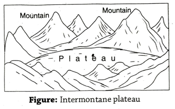
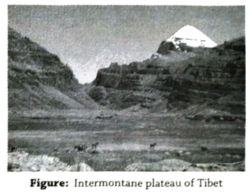
- Intermontane plateau: During the process of building of fold mountains (due to tectonic movements), the intervening area between two mountains comes under pressure and is forced to rise up and form plateaus. Since these plateaus are encircled by mountains, they are called intermontane plateaus. For example, Plateau of Tibet, Plateau of Anatolia in Turkey, Plateau of Iran, etc. The Plateau of Tibet is enclosed by Kunlun mountain in the north, and Karakoram, Tien Shan and Himalayan mountains to its south.
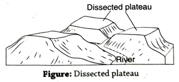
- Dissected plateau: Ancient plateaus are continuously eroded by the various agents of erosion like rivers, glaciers, winds, etc., and subsequently get reduced in height. The numerous rivers and their tibutaries and branches further divide the area into smaller blocks. Such a landform which is broken down by rivers is called dissected plateau or erosional plateau. For example, Chota Nagpur Plateau and Malnad Plateau (part of Karnataka Plateau) in India.
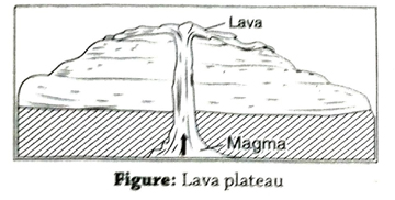
- Lava plateau: Molten magma from the Earth’s interior comes up to the surface through cracks and fissures in the weaker zones of the crust and gets deposited there. This lava slowly cools down and solidifies to form lava plateaus. For example, Lava Plateau or Deccan Trap region in northwestern part of south India, Colombia Snake Plateau in the United States of America, etc.
- Continental plateau: When ancient landforms on the Earth’s surface separate from each other as a result of tectonic activity, they form plateaus. They are also called shield areas and are resistant to earthquakes. For example, the Deccan Plateau in south India and the Arabian Plateau.
2. Give a detailed account of dissected plateau and intemontane plateau.
Ans. Dissected plateau: A detailed account of dissected plateau is given below-
Definition: When any large and ancient plateau undergoes erosion by various physical factors like rivers, winds, etc., for a long time, and is divided into smaller parts or is dissected, it is called dissected plateau.
Origin: Plateaus are usually made up of hard and soft rocks. Various agents erosion like rivers, winds, etc., erode the softer rocks and create deep gorges or valleys. On the other hand, the hard and resistant rocks remain as dissected plateaus.
Characteristics: 1. Dissected plateaus are usually formed as a result of erosion. 2. They are moderate in height. 3. After erosion, dissected plateaus form ‘mesas’ and ‘buttes’.
Examples: Chota Nagpur Plateau, Karnataka Plateau, Malnad region, Bundelkhand and Bagelkhand in Madhya Pradesh.
Intermontane plateau: An intermontane plateau is described below-
Definition: When a plateau is located between two or more mountains, it is called an intermontane plateau.
Origin: When a mountain rises up due to plate movements, its middle portion rises above its surrounding parts to form a plateau.
Characteristics: 1. Intermontane plateaus reach up to great heights. 2. The formation of these plateaus are associated with the formation of fold mountains. 3. These plateaus are extensive in nature.
Examples: Plateau of Tibet, Plateau of Iran, Pamír Plateau, etc. The Tibetan Plateau is encircled by Kunlun mountain in the north, Karakoram mountains in the southwest and the Himalayas in the south.
3. Describe continental plateau and lava plateau.
Ans. Continental plateau: A brief description of Continental plateau is as follows-
Definition: When parts of an ancient plateau separate from each other as a result of tectonic activity and form plateaus, they are called continental plateaus.
Origin: As a result of tectonic activity, parts of ancient plateaus get separated from each other. After erosion by various agents like rivers, glaciers, winds, etc., for a long time, these turn into plateaus. Since they cover extensive areas over continents, they are called continental plateaus. They are also known as ancient plateaus or shields.
Characteristics: 1. They are quite old according to geological age (more than 100 million years). 2. They have formed as a result of erosion over a long period. 3. The land is stable in continental plateau regions. 4. These plateaus are rich in mineral reasources.
Examples: Brazilian Plateau, Deccan Shield in India, Canadian Shield, etc. South Africa, Antarctica, Greenland, etc., also have widespread areas of such plateaus.
Lava plateau: A brief description of lava plateau is-
Definition: During volcanic eruptions, the molten magma comes out to the Earth’s surface and accumulates there to form lava plateaus.
Origin: When magma comes out through cracks and fissures and accumulates on the Earth’s surface, the plateau that starts forming is called a lava plateau. When this happens on several occasions, the entire area gains height and a lava plateau is thus formed.
Characteristics: 1. This is a type of depositional plateau. 2. It is formed as a result of volcanic activity. 3. Basalt is a common rock here. 4. The hills located on such plateaus also have flattened tops.
Examples: Deccan Plateau in south India, Malwa Plateau in northwestern India, Columbia Snake Plateau in the United States of America, etc.
4. Discuss, the importance of plateau with examples.
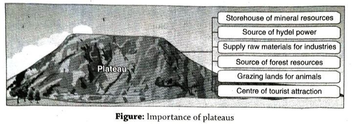
Ans. Importance of plateau: Importances of plateau are as follows-
- Storehouse of mineral resources: Many types of mineral resources like iron ore, coal, copper ore, limestone, etc., are available here in large amounts. The Chota Nagpur plateau is called the ‘Storehouse of India’s mineral resources’.
- Source of hydel power: Since the rivers flowing over plateaus are swift-flowing (due to the undulating topography), these rivers can easily be used for generating hydroelectricity. This is prevalent especially in the Deccan Plateau in south India.
- Supply raw materials for industries: Abundance of raw materials (mineral resources), electricity (hydro and thermal) and availability of cheap labour, make these areas ideal for the development of industries.
- Source of forest resources: Settlements in plateau areas are usually very sparse. As a result, most parts of the plateaus are covered with dense forests. These forests provide timber, honey, wax, flowers, fruits, etc., in large amounts.
- Grazing lands for animals: Since most of the large plateau regions of the world have dry and arid climate, there are vast expanses of green pastures, which are ideal for grazing animals. This provides the chief livelihood to the people living in plateaus.
- Centre of tourist attraction: Springs, waterfalls, mining areas, industrial areas, forest-based livelihood, and the scenic beauty of these regions attract both domestic and international tourists.
- Other importance: 1. The rocks, mineral resources, landforms, etc., of plateau regions are important areas of research for geologists. 2. The livelihood, culture, socioeconomic condition of the tribal people residing in the plateaus are significant for the study of Geography. These are some of the significant roles of a plateau.
Short Explanatory Answer Type Questions
1. Delineate the causes of formation of plateaus.
Ans. The following three major causes lead to the formation of plateaus
- Geotectonic activity: The ancient landmasses on the Earth’s crust separate and move away from each other and gain in height as a result of plate movements. These higher landmasses form plateaus. For example, the Arabian Plateau, the Deccan Plateau in south India, etc.
- Weathering and erosion (due to various agents): Landmasses of higher altitudes are worn down and reduced in height due to the combined effect of weathering and erosion by water, wind, solar insolation, glaciers, etc. As a result, plateaus are formed which are usually flat (tableland) in nature with scattered hills and low peaks here and there. For example, the Chota Nagpur plateau in eastern India.
- Deposition of lava: Magma or lava from beneath the Earth’s crust comes out through cracks or fissures present in the crust. On coming in contact with the atmosphere, they cool down and solidify as horizontal layers of rocks and form lava plateaus. For example, the lava plateau of northwestern Deccan Plateau.
2. What is the influence of plateaus on human life?
Ans. Plateaus have various influences on human life. Some of these are- 1. Most of the ancient plateaus are rich in mineral resources, e.g., Chota Nagpur Plateau in India, the Canadian Shield, etc. 2. Hydroelectricity can be generated from swift-flowing rivers which flow along the steep slopes of plateaus, viz., most of the big rivers flowing through the Deccan Plateau are utilised for generating hydroelectricity. 3. Due to the uneven and rocky nature of the plateaus, agricultural activity is hampered.
3. Why are plateaus rich in mineral resources?
Ans. The plateaus which are formed by igneous or metamorphic rocks, are usually rich in mineral resources. When the molten magma comes out and spreads horizontally on the Earth’s surface in layers and begins to cool, minerals like iron ore, aluminium, etc., consitituting these solidified rocks are formed here.
Again, minerals like gold, silver, copper are formed in the plateau regions constituted by metamorphic rocks.
The Chota Nagpur Plateau in India is rich in such mineral resources and thus this region is known as the ‘Mineral Reserve of India’.
4. Why is intermontane plateau always surrounded by fold mountain?
Ans. At the time of orogenic movement, when two continental plates collide with each other, the sedimentary deposit between those two plates get subpressed due to excessive lateral pressure. As a result, fold mountains originate along the border of the geosyncline and the middle part of the geosyncline forms an intermontane plateau. For this reason, an intermontane plateau is also known as median mass. Young fold mountains and intermontane plateaus are always formed simultaneously. So, an intermontane plateau is always surrounded by fold mountain.
Tibetan plateau, which is an intermontane plateau, is the largest plateau of the world. It is surrounded by two fold mountains-the Kunlun in the north and the Himalayas in the south.
5. ‘Waterfalls can be seen at the edge of plateaus.’ Explain.
Ans. Elevation of plateaus are at least 300 meter above the sea level. Generally, a plateau is formed by hard rocks. The top of a plateau is either flat or undulating and its sides are marked by steep slopes. Plateaus appear like a table and therefore, is often termed as ‘tableland’. After flowing over the surface of a plateau, a river falls down from a higher point to a lower point through the steep slope at the edge of the plateau and forms a waterfall. Hence, waterfalls can be seen at the edge of plateaus.
For example, Dassam Falls on the Subarnarekha river has formed at the edge of the Chota Nagpur Plateau.
6. ‘Despite being higher in altitude than a mountain, Pamir is considered as a plateau.’ Explain.
Ans. Elevation of the Pamir Plateau is higher than other plateaus of the world. So it is known as ‘Roof of the World’. Average height of Pamir Plateau is greater than 4800 metre. So, altitude of Pamir Plateau is higher than many mountain ranges but it is considered as a plateau. The reasons are as follows-
- Shape: Shape of the Pamir Plateau is like a large table. The landforms of plateaus appear like a table. For this reason a plateau is also termed as ‘tableland’.
- Topography of the surface: The surface of the Pamir Plateau is undulating and so its relative altitude is less than a mountain.
- Absence of conical hills: No peaks are visible in the Pamir Plateau, like mountains. However, there are some flat-topped mountains like Leo Pargil.
- Steep-sided: Although, the Pamir is an intermontane plateau, its sides are very steep, which is a typical characteristic feature of plateaus.
Short Answer Type Questions
1. What is plateau?
Ans. A landform with a height of more than 300 m and almost flat on the top with steep slope is called a plateau.
2. Why is a plateau called tableland?
Ans. A plateau is a vast extensive highland with undulating surface or flat top and steep sided. So, a plateau looks like a table. Thus a plateau is termed as table land is called tableland.
3. What is an intermontane plateau?
Ans. When fold mountains are formed as a result of tectonic activity, the intervening low land, lying between high fold mountains is known as an intermontane plateau. For example, the Plateau of Tibet lying between the Himalayas and Kunlun mountains.
4. Where do you find dissected plateaus in India?
Ans. Parts of Chota Nagpur Plateau, Deccan Plateau and Meghalaya Plateau are dissected plateaus.
5. What is the Deccan Trap?
Ans. The step-like landform seen in the Deccan Plateau is known as Deccan Trap. The Swedish term ‘trap’ means ‘step’. Such a landform has developed as a result of erosion for a long time on the basaltic rocks (formed due to lava accumulation through fissure eruption).
6. What is a shield?
Ans. An ancient plateau (created about 100 crore years ago) which has formed due to age- long weathering and erosional processes acting upon the initial landmass is known as a shield. They are geologically stable. For example, the Canadian and Brazilian Shields.
7. Why is Pamir called the ‘Roof of the World’?
Ans. Pamir is the world’s highest plateau with an average altitude of 4,800 m above sea level. This plateau has an almost flat top wih steep slopes on all sides resembling a roof. This is why Pamir is called the ‘Roof of the World’.
8. Where are depositional plateau found in India?
Ans. Depositional or at lava plateau lies Maharastra plateau which is the north western part of Deccan Plateau. This plateau and the extensive area of south India is composed of basalt rock.
Multiple Choice Type Questions [MCQ type]
Write the correct answer from the given alternatives
1. ‘Roof of the World’ refers to the-
A. Pamir Plateau
B. Tibetan Plateau
C. Arabian Plateau
D. Ladakh Plateau
Ans. A
2. The largest plateau in the world is the-
A. Tibetan Plateau
B. Pamir Plateau
C. Deccan Plateau
D. Meghalaya Plateau
Ans. A
3. The average elevation/altitude of a plateau is at least-
A.200 metre
B. 300 metre
C. 400 metre
D. 500 metre
Ans. B
4. An example of a lava plateau in India is-
A. Ladakh Plateau
B. Chota Nagpur Plateau
C. Deccan Plateau
D. Meghalaya Plateau
Ans. C
5. A plateau encircled by mountains is the-
A. Tibetan Plateau
B. Brazilian Plateau
C. Chota Nagpur Plateau
D. Deccan Plateau
Ans. A
6. An example of a dissected plateau is the-
A. Chota Nagpur Plateau
B. Pamir Plateau
C. Ladakh Plateau
D. Brazilian Plateau
Ans. A
7. Meghalaya Plateau is a(n)-
A. dissected plateau
B. plateau formed by lava
C. intermontane (enclosed by mountains) plateau
D. plateau formed by faults
Ans. A
8. The following is known as a ‘tableland’-
A. hill
B. plateau
C. mountain
D. plain
Ans. B
Very Short Answer Type Questions
Fill in the blanks with suitable words
1. A dissected plateau is formed as result of ………
Ans. erosion
2. Another name for plateau is ……..
Ans. tableland
3. The highest plateau in India is ………
Ans. Ladakh
4. The Siberian Shield of Russia is a ……… plateau.
Ans. continental
5. The largest intermontane plateau in the world is ……..
Ans. Tibetan Plateau
6. The altitude of the Tibetan Plateau is ……..
Ans. 4,500 metre
7. The Deccan Plateau in south India is made up of ……. rocks.
Ans. igneous
8. Pamir Plateau is also known as …….. the Earth.
Ans. Roof
9. Tibetan Plateau is located in ……..
Ans. China
10. Columbia Plateau is an example of……..
Ans. lava plateau
11. Altiplano Plateau between Peru and Bolivia is an example of …….. plateau.
Ans. lava
TOPIC – D
Plains
Long Answer Type Questions
1. What is plain? Classify plains and analyse the origin and development of each of them.
Ans. Plain: A large expanse of land, having gentle undulations, at the sea level or at a slightly higher altitude (less than 300 m), is called a plain.
Classification of Plains: Plains can broadly be divided into three categories-
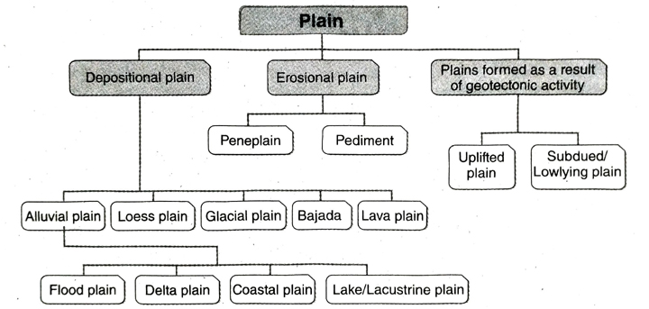
- Depositional plain: Of the three types of plains based on origin, this type is most important. Depositional Plain is of five types, namely-
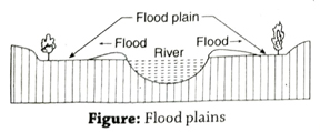
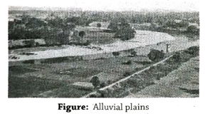
- Alluvial plain or flood plain: When silt is deposited on the two sides of an overflowing river (during floods) or in a delta region, they form alluvial plains or flood plains. For example, Ganges Plain in India, Hwang Ho Plain in China, etc.
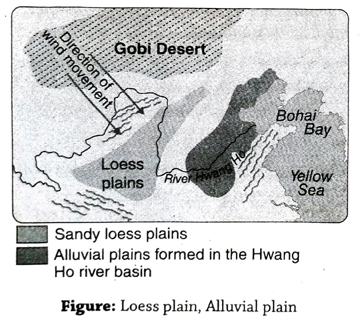
- Loess plain: When sand is blown away to distant places from another region and deposited in some lowlying area, a loess plain is formed. For example, the loess plain of Hwang Ho basin has been formed by the sand of the Gobi Desert.
- Glacial plain: During the Glacial Age, continental ice sheets have eroded the uneven topography over which it moved and have eventually flattened the relief and formed glacial plains. For example, the Prairie region of North America and the glacial plain of northern Europe.
- Bajada or desert plain: The sand, pebbles and small rock fragments are carried down the slopes of mountains and get deposited in the foothill zone forming Bajadas. For example, Bajada in the foothill zone of Atlas Mountain adjoining Sahara Desert of North Africa.
- Lava plain: Molten magma comes out of the Earth’s interior through cracks and fissures on the Earth’s surface. Here, it cools down and solidifies to form plains. These plains are called lava plains. For example, the lava plain located in the northern part of the Deccan Plateau.
- Erosional plain: Plains are formed in two ways as a result of erosion caused by agents . like river, glacier, wind, etc. They are- 1. peneplain, and 2. pediment.
- Peneplain: When a landmass is reduced in elevation as a result of erosion over a long time, it is called a peneplain, which means ‘almost a plain’. For example, parts of Chota Nagpur Plateau in India.
- Pediment: Due to the action of strong winds in arid regions, sand is deposited in the foothill zone of mountains and hills, forming a plain. This is called pediment. For example, the foothill zone of Atlas Mountain of the Sahara region in Africa.
- Plains formed as a result of geotectonic activity: Some plains have formed as result of geotectonic activity. For example, 1. uplifted plain, and 2. subdued or lowlying plain.
The sea floor is uplifted due to diastrophism or tectonic activity and is exposed to the surface. These are called uplifted plains and when the uplands subside, they form subdued plains. The coastal plain of Mexico Sea in North America (uplifted plain) and the Turan Lowland (subdued plain) are some examples.
2. Give an account of different types of depositional plains.
Ans. Classification of depositional plain: Depositional plains are of three types. They are as follows-
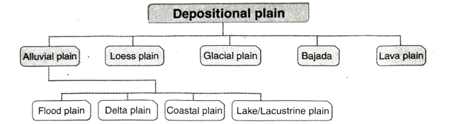
- Alluvial plain: Silt and sand which get deposited on both the banks of a river (flood plains) or in delta regions form depositional plains. For example, Ganges Plains, Hwang Ho Plain, etc. Alluvial plains are again divided into four types-
- Flood plain: When a river overflows its banks during floods every year, fresh silt is laid on both sides of the river in the plains. These are called flood plains. For example, the middle and lower courses of river Ganges and the Brahmaputra valley have many such flood plains.
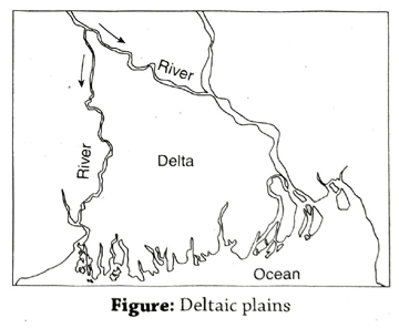
- Delta plain: A triangle-shaped landform formed in the lower course of a river where it enters the sea is called a delta. The plain which forms at such a delta is called a delta plain. For example, the world’s biggest delta has developed in the lower part of the GangaBrahmaputra river where it meets the sea (Bay of Bengal).
- Coastal plain: When silt, sand, pebbles, washed away by sea waves, winds, rivers get deposited in the shallow sea, a coastal plain is formed. For example, the Palestine Plain has formed by the action of waves and oceanic deposits and the Western and Eastern Coastal Plains of India have formed by the action of rivers, winds, etc.
- Lake or Lacustrine plain: These are formed by deposition of silt, sand, pebbles, etc., on any lake bed. They are also called lacustrine plains. For example, the Great Basin in the United States of America and lake plains of Red river basin in Canada.
- Loess plain: When sand particles are blown away form one place and deposited in lowlying places at a great distance, they are called loess plains. For example, the loess plain of China’s Hwang Ho river basin has been formed by the sand of the Gobi Desert.
- Glacial plain: The continental ice sheets of the Glacial Age have eroded the Earth’s surface on which it moved and created glacial plains. The Prairie region of North America and the Glacial Plain of northern Europe are such examples.
- Bajada or desert plain: When sand, pebbles, etc., are deposited in the foothill areas of any hill or mountain, they form desert plains. For example, Bajadas have formed in the foothills of the Atlas Mountain adjoining the Sahara Desert.
- Lava plain: Hot molten magma comes out through cracks and fissures of the Earth’s surface and gets deposited to form lava plains. For example, the lava plains in the northern part of the Deccan Plateau.
3. Give an account of structural plain and erosional plain.
Ans.Structural plain: A brief description of structural plain is as follows-
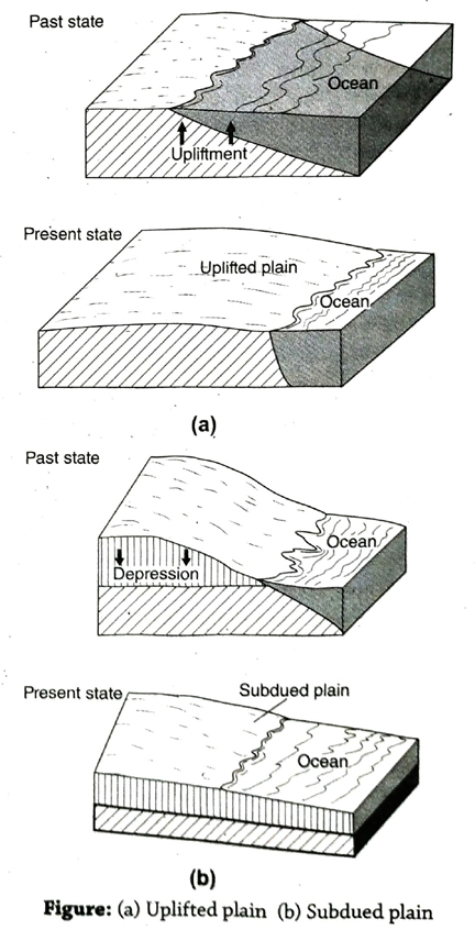
Definition: When any landmass gets either uplifted or it subsides as a result of geotectonic activity (epeirogeny), it forms a structural plain.
Types: Structural plains are of two types- (1) uplifted plain and (2) subdued or lowlying plain.
Origin: (1) When any shallow seabed is uplifted near a coast due to tectonic activity, it forms an uplifted plain. (2) When any elevated landmass subsides as a result of tectonic activity, it forms a subdued plain.
Characteristics: (1) These plains are formed as a result of geotectonic activity. (2) Such plains are generally formed near coasts. (3) These plains are formed all of a sudden.
Examples: The coastal plain of Mexico Sea in the United States of America and the Turan lowland are examples of uplifted and subdued plains respectively.
Erosional plain: An erosional plain is explained below-
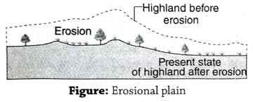
Definition: When any ancient highland is affected by erosion by various agents like rivers, glaciers, winds, etc., over a long period, they lose their elevation gradually and form erosional plains.
Origin: Any upland or plateau is formed of both hard and soft rocks. In due course of time, due to continuous erosion over long periods, the landform is modified into a gently sloping plain.
Characteristics: (1) Such plains are formed as a result of erosion of uplands. (2) Some isolated rounded hills made up of hard and resistant rocks called monadnocks lie here and there. (3) Erosional plains are not fertile.
Examples: Some parts of the Chota Nagpur Plateau are erosional plains.
4. Discuss the importance of plains with examples.
Ans. Importance of plains: Importances of plains are as follows-
- Benefits of agricultural activity: The fertile silt-laden plains formed by river deposition are ideal for practising agriculture and that is why the main livelihood of the people residing here is agriculture. For example, large amounts of paddy, sugarcane, etc., are cultivated in the Ganga Plain.
- Improved transport and communication system: Being a level or flat land, plains are ideal for constructing roads and railways. Waterways (rivers) can also be used as a mode of transport, thereby leading to a developed system of transport and communication.
- Conducive climate: Compared to mountains and plateaus, climate is quite pleasant in the plains. Temperature is not extreme here and rainfall is also high due to presence of rivers, canals, creeks, lakes, ponds, etc.
- Settlements: The flat land, fertile soil, developed transport and communication system, conducive climate, opportunities of employment, etc., have all led to the growth of settlements here. For example, the Ganges Plain of north India.
- Development of industries: Flat land, pleasant climate, developed transport and communication system, availability of labour (the plains being a densely populated area), availability of raw materials, etc., have all contributed to the development of industries in the plains.
- Advantage of urbanisation : Due to the above mentioned advantages, the plains are the places of urban development and culture. The transformation of rural to urban ways of life is called urbanisation. Major cities like Delhi, Kolkata, Mumbai, Chennai, etc., have all developed in the plains.
- Other importance: (1) It is advantageous to develop grazing lands where animals are reared in the parts of the plains which are uncultivable. (2) Fisheries have a great scope of developing here, due to the presence of numerous rivers, wetlands and proximity to the sea (in case of coastal plains). (3) The culture of the area is enhanced due to the fact that it is a densely populated area where education, healthcare facilities, etc., have much scope for development. (4) Business, trade and commerce also flourish in the plains because they are developed areas from the point of view of agriculture and industries.
Short Explanatory Answer Type Questions
1. How do loess plains and glacial plains form?
Ans. Formation of loess plains: Fine particles of sand and silt, blown by winds, are transported to distant places and deposited in lowlying places, thereby forming loess plains. The fine sand particles from the Gobi Desert of Central Asia, being blown away by winds and carried away to the distant Hwang Ho basin of China, get deposited and form loess plains there.
Formation of glacial plains: The sediments called moraines consisting of gravels, pebbles, cobbles and rock fragments, which have been brought down by moving glaciers and deposited at the foothills, form glacial plain. The Prairies of North America and the European Plains have been formed in this manner.
2. Why are natural levees formed on the sides of a flood plain?
Ans. The slope of the land becomes gentle and the velocity of the river decreases when a river enters its middle and lower courses. During monsoons, the capacity of the river exceeds due to presence of huge volume of water. The river cannot hold this excess water and thus causes overbank flooding. Sand, silt clay which are carried by the river got deposited on both the sides of river bank during floods. After the flood water recedes, sand, silt, clay get deposited on the river banks. The deposition of such sediments every year gradually increases along the banks of the river bed. Such raised banks or embankments like ridges are known as natural levee. So, flood plain and natural levees are simultaneously formed and so natural levees can be seen on both sides of a flood plain.
3. ‘Most of the world’s population resides in plains.’ Explain.
Ans. The reasons why most of the world’s population reside in plains are as follows-
- Favourable opportunities for agricultural activities: Most plain lands all over the world have very fertile soil which is suitable for different agricultural activities.
- Availability of water: Since the major perennial rivers flow over the plains, there is constant supply of drinking water, water for domestic purposes, water to be used for irrigation and industrial purposes, etc.
- Job opportunities: Due to the easy availability of fertile soil, flat land, developed transport system, etc., there is ample scope for agricultural pursuit and industrial development, and hence a lot of job opportunities.
- Advantages of infrastructure: Since settlements have developed on the flat land, infrastructural facilities like education and health facilities, and a proper transport system have developed.
Short Answer Type Questions
1. Where are depositional or aggradational plains found in India?
Ans. In the northwestern part of the Deccan Plateau (including Maharashtra Plateau) and covering a large part of south India, we find depositional plains formed as a result of accumulation of lava (due to fissure eruption from beneath the Earth’s surface) and basically formed of basaltic rocks.
2. Where are flood plains found in India?
Ans. In the lower reaches and also in the middle courses of the main rivers of North India, we find flood plains. For example, on both sides of river Ganges, viz., near Patna and Munger in Bihar.
3. What is a plain?
Ans. A large expanse of land, having gentle undulations, at the sea level or at a slightly higher altitude (less than 300 m), is called a plain. For example, the Ganga Plains.
4. Where would you find the world’s largest delta?
Ans. The world’s largest delta is found between the lower reaches of rivers Ganges and Brahmaputra.
5. What is meant by uplifted plain?
Ans. When a plain is formed as a result of the upliftment of any existing plain, as a result of tectonic activity, it is known as an uplifted plain.
6. What is meant by subdued plain?
Ans. When any highland (having the characteristics of a plain) subsides to a lower level due to tectonic activity, it forms a subdued plain.
7. What is a pediment?
Ans. In the arid (dry) or desert area, we find a gently sloping foothill zone formed by accumulation of sediments consisting of boulders and pebbles. This region is known as a pediment. ‘Pedi’ means foothill and ‘mont’ means hill or mountain. For example, pediments are formed in the foothill region of the Atlas Mountains in North Africa.
8. What are flood plains?
Ans. When there is a sudden flood in a river, the water overflows its banks on either side and the low-lying tracts of land get flooded. Later on, when the water recedes, the silt carried by this water settles down on these plains, giving rise to fertile flood plains on either side of the river. For example, the Ganges Plains (in the middle and lower courses of the river).
9. Write a note on the importance of plains.
Ans. 1. Agriculture is extensively carried out in the plains. 2. Transport lines can easily be constructed on the plains because of the flat land and soft soil. 3. Since agriculture and transport are developed here, industries can be developed on the plains. 4. About 90% of the world’s population lives in the plains.
10. Why is ‘peneplain’ named so?
Ans. When an ancient plateau is subjected to age-long weathering and erosion by various agents like rivers, winds, it is reduced to a lower level and looks almost like a plain. Such landforms are called ‘peneplains’ (meaning ‘almost a plain’). Most of the area is a flat, level land, with low hills called monadnocks scattered here and there. For example, parts of the Chota Nagpur Plateau is a peneplain.
11. Give examples of one uplifted plain and one subdued plain.
Ans. Example of uplifted plain is-the coastal plain of Gulf of Mexico.
Example of subdued plain is-the plain of Turan.
12. What is a monadnock?
Ans. Some low altitude conical hills which are scattered in a peneplain and stand out because they are made up of hard resistant rocks, are called monadnocks. For example, Susunia Hill, Tagore Hill of Chota Nagpur Plateau.
13. What is an inselberg?
Ans. Sometimes, some isolated hills lie sporadically in desert plains. These residual hills are composed of hard resistant rocks. and their elevations are not very high. These types of isolated hills or residual mountains are called inselbergs. These low-lying hillocks are formed by erosional activities of wind and flowing water. Inselberg is a German word which means ‘island mountain’. Inselbergs can be seen in the Sahara desert of Africa.
14. What is bajada?
Ans. Bajada is a type of depositional plain. When sand, pebbles etc. are deposited in the foothill areas of any hill or mountain of a desert region, a depositional plain is formed. This plain is known as bajada. This plain is mainly formed by depositional work of wind and water. Bajada can be seen at the foothill of Atlas mountain in Africa.
Multiple Choice Type Questions [MCQ type]
Write the correct answer from the given alternatives
1. The Hwang Ho river basin is a(n)-
A. uplifted plain
B. subdued plain
C. loess plain
D. eroded plain
Ans. C
2. A loess plain is formed by-
A. action of rivers
B. wind action
C. glacial action
D. action of sea waves
Ans. B
3. The Malwa Plains of Gujarat is a(n)-
A. lava plain
B. erosional plain
C. flood (silt) plain
D. desert plain
Ans. A
4. An example of an uplifted plain is-
A. Vindhya Plain
B. Eastern Coastal Plains of India
C. Plain of Turan
D. none of these
Ans. B
5. Loess plain is a type of-
A. erosional plain
B. depositional plain
C. tectonic plain
D. none of these
Ans. B
6. Large expanses of flood plains are seen in-
A. Godavari river basin
B. Narmada river basin
C. Tapti river basin
D. Ganges river basin
Ans. D
7. A subdued plain formed as a result of tectonic activity is the-
A. Deccan Trap
B. Turan Lowland
C. Mississippi Basin
D. Siberian Shield
Ans. B
8. Moraines or Moraine Plains are seen in-
A. karst regions
B. glacial regions
C. equatorial region
D. hot desert regions
Ans. B
9. Loess plain is found in-
A. China
B. Japan
C. India
D. Bangladesh
Ans. A
10. Natural levees are formed as a result of-
A. riverine erosion
B. glacial erosion
C. wind erosion
D. river deposition
Ans. D
11. ‘Pediments’ are formed as a result of-
A. erosion by glacier
B. riverine erosion
C. erosion by sea waves
D. wind erosion
Ans. D
12. Bajada is a-
A. erosional plain
B. depositional plain
C. geotectonic plain
D. oceanic plain
Ans. B
Very Short Answer Type Questions
Fill in the blanks with suitable words
1. A hill formed of hard rock in a peneplain is called ……..
Ans. monadnock
2. …….. occupy the maximum part of the Earth’s total area of land.
Ans. Plains
3. The Turan Lowland is an example of …….. plain.
Ans. subdued
4. The Nile basin is an example of ……. plain.
Ans. silt
5. Population density is …….. in plain region.
Ans. more
6. Small elevated hills on the plain of dry region are called ……..
Ans. inselberg
If the statement is true, write ‘T’ and if false, write ‘F’ against the following
1. Loess plain is found along the Hwang Ho river basin in China.
Ans. T
2. Pediments are formed in arid regions.
Ans. T
3. A delta plain is formed by deposition of fine silt.
Ans. T
4. Old plain is known as shield.
Ans. F
5. Formation of flood plain is responsible for the plate movement.
Ans. F
Answer in one or two words
1. Which is the largest delta in the world?
Ans. Ganga-Brahmaputra Delta.
2. What is the main reason for the formation of an uplifted plain?
Ans. Geotectonic activity.
3. Which is the largest plain in the world?
Ans. Siberian Plain.
4. Give an example of an exogenic force/agent of erosion.
Ans. Work of a river/fluvial action.
5. Give an example of a structural plain.
Ans. Turan Lowland.
6. Give an example of a karst topography in India.
Ans. Borra Caves in Andhra Pradesh.
7. What is the residual hill in a peneplain called?
Ans. Monadnock.
8. Give an example of lacustrine plain of India?
Ans. Kashmir Valley.