WBBSE 9th Class Social Science Solutions Geography & Environment Chapter 6 Hazards and Disasters
WBBSE 9th Class Social Science Solutions Geography & Environment Chapter 6 Hazards and Disasters
West Bengal Board 9th Class Social Science Solutions Geography & Environment Chapter 6 Hazards and Disasters
WBBSE 9th Class Geography & Environment Solutions
Salient points – At a Glance
- The extreme events that disrupt our normal activities and our daily lives and originate due to the natural causes or human activities or combined activities of both, are called hazards.
- The temporary or permanent events caused by the natural or human activities endangering the human life causing great damage to life and property, which degrade the quality of the environment and last for a long time, are called disasters.
- French word ‘des’ means ‘bad’ and ‘astre’ means ‘star’ and the aggregation of these two words is disaster (badstar).
- Many lives and huge amount of property were damaged by flash flood on 16 July, 2013 in Uttarakhand. It was a disaster.
- Huge amount of property was damaged and millions of people were killed due to the Tsunami on 26 December, 2004 in the surrounding countries of Bay of Bengal in south-east Asia.
- In 2001, millions of people died due to the earthquake in Bhuj City in Gujarat.
- In 1902, Saint Pierre city was completely destroyed due to the volcanic eruption of Mt. Pelee volcano of West Indies.
- The landslide prone zones of West Bengal are Darjeeling and Kalimpong. But, the hilly areas of Alipurduar and Jalpaiguri district also face landslide.
- The most cyclone prone areas of West Bengal are North and South 24 Parganas and Purba and Paschim Medinipur districts.
- Drought prone areas of West Bengal are western plateau and its adjacent regions (Purulia, Bankura, Birbhum, Paschim Bardhaman, Paschim Medinipur and Jhargram districts).
- The most flood prone areas of West Bengal are Sundarban region, coastal region of Purba Medinipur, northern Terai region and Rarh plain due to the releasing of excessive water from barrages and reservoirs.
- Richter Scale is a measuring scale of earthquake intensity.
- In 1935, CF Richter invented the measuring scale of the earthquake intensity.
- It is not possible to stop disaster in most of the time. But some measures can be taken to tackle the effects of disaster to reduce the loss of life and damage of property. Such measures are called disaster management.
- Three steps of disaster management are during pre-disaster management, disaster management and post-disaster management.
- The possibility of loss or damages due to any hazard or disaster is called risk.
- While the disaster or hazard intensified, people could not resist and surrendered to it. This is called vulnerability.
- All the essential materials that are sent to the disaster affected people are called relief.
- Disaster mitigation means the measures that are taken before a disaster to eliminate or reduce the intensity of damage.
- Rehabilitation is a process, which brings back the disaster affected people into normal life after disaster.
TOPIC – A
Different Types of Hazards and Disasters
Short Explanatory Answer Type Questions
- Most of the hazards are difficult to predict and occur all of a sudden.
- Hazards may be nature-induced, humaninduced or even a combination of both.
- The expansion of hazard is generally over smaller areas and its magnitude is comparatively low.
- Hazards have the potential for causing injury to life or damage to property or the environment.
- Hazards with higher potential leads to disasters.
- Distressed normal life: The normal public lives and activities are hampered and disrupted because of a disaster.
- Casualties: A large number of human and animal life is devastated by a disaster. Damages and loss of property also take place.
- Magnitude: The magnitude of a disaster is not always the same. They vary from intense to moderate.
- Speed of occurrence: Disaster can be slow and predictable, or they may even be sudden and temporary.
- Affects the environment: The negative environmental effects of disasters are by and large severe and persist for long.
- Disfunctioning of essential services: The functioning of essential services such as transport and communication get disrupted.
- Combined effect of several factors: A disaster is a combination of hazard, vulnerability and insufficient capacity or measures to reduce the potential chances of risk.
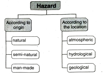
- Natural hazard: Natural hazards characterise those elements of the physical environment that are detrimental to human beings and are caused by forces extraneous to us. More precisely, the term ‘natural hazard’ refers to all atmospheric, hydrological and geological phenomena that, because of their location, intensity and frequency have the potential to affect adversely the human beings, their constructions or their activities.
- Semi-natural hazard: Hazards that are caused by the combination of natural and man-induced processes are known as seminatural hazards. For instance, landslide is a semi-natural hazard as it can be caused by natural processes (such as heavy or prolonged rainfall, earthquakes, volcanic eruptions, slope undercutting by rivers) and can also be caused by human activities (such as slope excavation and loading, land use changes, irrigation, blasting vibrations, water leakage from utilities and such others).
- Man-made hazard: Man-made hazards are caused by the elements like unscientific human activity, negligence or error, superstition or the failure of a man-made system. Man-made hazards can be controlled by increasing awareness among communities.
- Atmospheric hazard: These hazards have their root in the atmosphere. For example, cloudburst, cyclone and such others.
- Hydrological hazard: These hazards have their root in the waterbodies. For example, flood, tsunami and such others.
- Geological hazard: These hazards have their root in the interior of the Earth. Landslides, earthquakes and such others are examples of geological hazard.
- Unscientific activities: Faulty and unscientific activities often lead to maninduced hazards. For instance, unplanned construction of houses on the hill slopes, faulty farming on the hill slopes or even carving roads across the slopes of hills intensifies the probabilities of landslides.
- Illiteracy: Illiteracy leads to lack of knowledge, intolerance and even negligence. All these lead to common maninduced hazards like arson, civil disorder and even terrorist activities.
- Ungoverned population growth: Ungoverned population growth can lead to competition for scarce resources and susceptibility to diseases, that in turn, may cause civil strife and even loss of human life.
- Riot: Ethnic conflict or communal riot causes hazard due to superstition, bigotry etc. It damages the human life and property which disrupt the social and economic life.
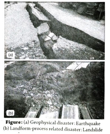
- Geophysical disaster: Disasters that are caused due to tectonic disturbances are called geophysical disasters. Earthquakes and volcanisms are examples of geophysical disasters.
- Landform-process related disaster: Landform processes like riverbank erosion, landslides in mountainous areas, coastal erosion due to sea waves, etc., may give rise to disasters if they occur on a macro-scale.
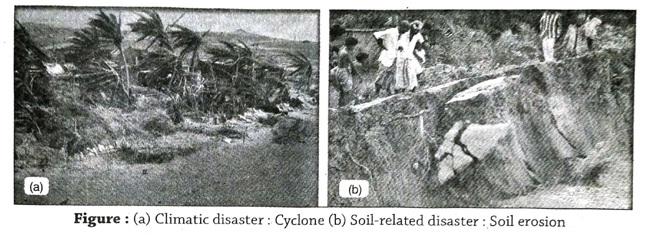
- Meteorological/Climatic disaster: Disasters that are caused by extreme weather events are known as meteorological disasters. Storms, tropical cyclones, heat or cold waves, floods and droughts are examples of meteorological disasters.
- Extraterrestrial disaster: Disasters that are caused by asteroids, meteoroids, comets and other extra-terrestrial elements striking the Earth are called extra-terrestrial disasters. Example-Meteorite strikes.
- Soil disaster: Various causes like soil erosion, increase of salinity of soil and loss of fertility are the reasons of soil disaster. Excessive salinity of the soil hampers the productivity that results scarcity of food. Example: This type of disaster frequently occurs in Rajasthan.
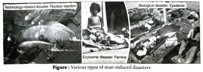
- Technology-related disaster: A technology-related disaster is the failure of modern systems, like, unchecked exhaust fumes from vehicles, untreated wastes from industries, leakage of radioactive minerals from nuclear power plants, etc., which harms people and also pollutes the environment.
- Economic disaster: An economic disaster is the widespread disruption or collapse of a national or regional economy, possibly causing financial loss, hoarding, famine, inflation, etc.
- Biological disaster: Disasters caused due to the exposure of human beings to toxins, viruses leading to epidemics, are known as biological disasters. Extinction of any species is also possible.
- Disasters due to other complex emergencies: These involve a breakdown of administration, riot, religious conflicts, war, etc.
- Natural causes of flash floods: The natural causes of flash floods are-
- Rapid rain: A flash flood may occur when it rains rapidly on saturated soil or dry soil with poor absorption ability. The run-off collects in gullies and streams and as they join to form larger volumes, it often exceeds the carrying capacity of the stream. This may lead to occurrence of flash floods.
- Volcanic eruption: A flash flood may also occur in areas on or near volcanoes, when glaciers may have been melted by the intense heat after eruptions.
- Thunderstorms: Multiple or slow moving thunderstorms occurring over the same area can also produce a flash flood.
- Cloud burst: Cloud burst results excessive rainfall in a short period of time that can produce flash flood.
- Man-induced causes of flash floods: Dam failure is extremely destructive and can create a flash flood. In such an event, the energy of the water stored behind even a small dam is capable of causing loss and damage to life and property in the downstream areas of the dam.
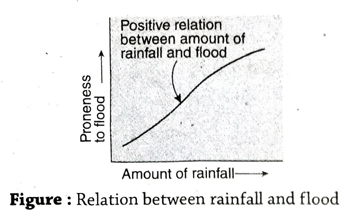
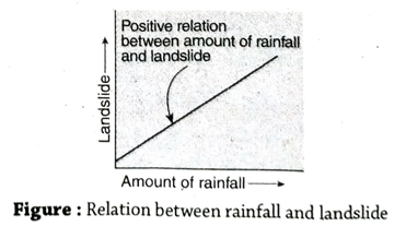
- Excessive rainfall: Excessive rainfall occurring over a prolonged period of time causes flood. Due to this excessive rainfall, the discharge of a river exceeds the capacity of its channel to carry. Thus the river overflows its banks causing flood. Therefore, excessive rainfall is positively related to flood.
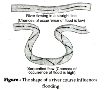
- The shape of a river course: The probability of flood increases if the course of a river is meandering rather than straight since the flow of the river is hindered by obstacles along its course and hence overflowing occurs.
- Snow melt: During the warm summers, the glacial snow in the mountains melt down. This results in the flow of large amount of water downslope within a short period of time. As the ground is almost frozen, water cannot penetrate or be absorbed. The water therefore, flows off the surface and runs into lakes, streams and rivers. This causes excess water to spill over the respective banks and results in snow-melt floods.
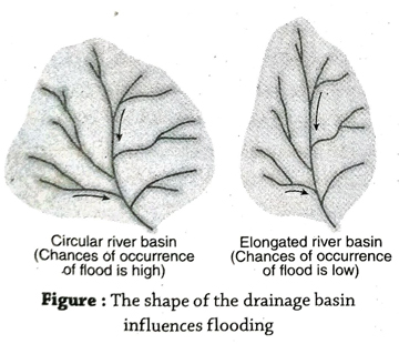
- Shape of the drainage basin: The possibility of flash flood increases in a drainage basin that is circular in shape rather than an elongated one. This is because, in the latter case, rivers have the capacity to carry water over longer distances.
- Slope of the river course or the relief of the land: The areas with steep slopes are less susceptible to flood as the rain water flows down the slopes. But the plain lands where the rain water cannot flow down the slopes are more susceptible to flood and water logging.
- Shallow riverbed: Water holding capacity and transportation power of river decrease due to the sediment action on the riverbed over a long time which makes the riverbed shallow. As a result, normal rainfall causes flood in the river.
- Cyclonic storm and intensity of tide: Spate and flood may occur in coastal regions due to cyclonic storms. Similarly, at the time of new moon and full moon the excess water that enters in river from sea, causes flood.
- Deforestation: Vegetation cover prevents soil erosion and also controls the amount of precipitation.
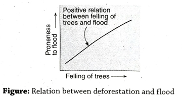 Deforestation increases soil erosion and the sedimentation of the eroded materials on the riverbed over a long period of time makes the riverbed shallow. As a result, the possiblity of occurrence of flood increases.
 - Modification of the catchment area: The land-use pattern of the catchment area changes with the of increasing number of settlements, urbanisation, industrialisation and the change in agricultural patterns. All these may subsequently lead to flooding.
- Change in the course of the river: Artificial modification in the course of a river such as construction of dams, development of irrigation system and such others to satisfy human needs may also lead to flooding in the long run.
- Meteorological drought: A drought is categorised as a meteorological drought, when actual rainfall over an area is significantly less than the normal amount of rainfall. Meteorological droughts need to be defined specific to particular regions as the atmospheric conditions that result in deficiencies of precipitation vary highly from region to region. Meteorological drought can also be defined as the actual precipitation departures from average amounts on monthly, seasonal or annual time scales. Drought can be classified into the following sub-types-
- Mild drought: When rainfall is 11% to 25% less from the normal rainfall.
- Moderate drought: When rainfall is 26% to 50% less than the normal rainfall.
- Severe drought: When rainfall is less than 50% of the normal rainfall.
- Hydrological drought: A hydrological drought occurs when there is a marked depletion of surface water causing very low stream flow and drying of lakes, reservoirs and rivers. Therefore, hydrological drought is related to the periods of precipitation deficits on surface or subsurface, water supply. can again be classified into two types-
- Surface water drought: This is caused when ponds, lakes and rivers dry up due to inadequate rainfall.
- Groundwater drought: When the level of groundwater decreases due to deficit of rainfall, groundwater drought occurs.
- Agricultural drought: An agricultural drought occurs when inadequate soil moisture produces acute crop stress and affects productivity in the long run. Inadequate topsoil moisture during the planting stage may obstruct germination, leading to low plant populations per hectare and a reduction of final yield. However, if topsoil moisture is sufficient for early growth, insufficiencies in subsoil moisture at this early stage may not impact final yield if subsoil moisture is replenished as the growing season progresses or if precipitation meets plant water needs.
- Permanent drought: It occurs mostly in arid desert regions. Crop production is not possible without irrigation, due to inadequate rainfall. In these areas, xerophyte type of vegetation is generally observed. For example, cactus, thorny shrubs, etc.
- Seasonal drought: It occurs in the areas with clearly defined wet and dry climates. Seasonal drought occurs due to large-scale seasonal circulation. This occurs mainly in monsoon areas.
- Contingent drought: This results due to irregular and variable rainfall, especially in humid and sub-humid regions. The occurrence of such droughts may coincide with growth periods of the crops when the water needs are critical and the greatest, resulting in severity of the effects i.e., yield reduction.
- People may be killed or injured.
- Built landscape such as houses may be destroyed.
- Transport and communication links may be interrupted and shops and business may be destroyed. This can subsequently lead to difficulty in trade.
- Water pipes may burst and water supplies may be contaminated.
- Fires can spread due to gas pipe explosions that can even lead to forest fires in certain areas.
- Landslides may occur.
- Tsunamis may cause flooding in coastal areas.
- Can lead to social unrest and heedless looting may take place.
- Plate tectonics: Due to prevailing high temperature and pressure, convection currents evolve in the viscous mantle below the earth’s crust. These convection currents cause the plates (parts of the earth’s crust) to move in different directions and at different speeds from those of the adjacent ones which at times cause earthquakes.
- Isostatic causes: Isostasy is the state of gravitational equilibrium between the Earth’s lithosphere and asthenosphere and in this process of trying to attain a hydrodynamic equilibrium, earthquakes may take place.
- Formation of fold mountains: Formation of new fold mountains may also result in occurrence of earthquakes.
- Volcanism: Volcanic activity may also cause earthquakes.
- Landslides and avalances: During landslides and avalanches a huge mass of snow, ice and rocks slide down along the steep slopes of mountains, that may cause earthquakes.
- Meteorite: Meteorite impacts could cause larger earthquakes than have ever been observed. Meteor crater in Arizona in the United States in an example.
- Collapse of subterranean cavities: The removal of minerals and other materials from the Earth may cause instability, leading to sudden collapse of subterranean cavities, that may cause local tremors. In karst areas, due to the action of underground water the sudden collapse of ground surface also cause earthquake.
- Faulty construction of dams: It is well accepted that large dams can cause earthquakes. Dams cause earthquakes due to the extra pressure of water created in the minor cracks and fissures in the ground under and near a reservoir.
- Nuclear testing: Nuclear testing may also trigger earthquakes. As example, in 1999, earthquake occured due to the explosion of nuclear testing at Pokhran in Rajasthan.
- Dynamite blasting for road construction: Blasting of rocks by dynamite for construction of roads may trigger earthquakes.
- Collapsed roof of the mines: Earthquake can occur locally due to the collapsing of the roof of the mines if the pit of mines are not perfectly filled with sand. This kind of earthquake often occurs at Ranigange.
- Geological causes: Weak or sensitive materials of the hill-slopes and the abundance of weathered materials make the mountainous regions prone to landslide.
- Climatic causes: Mountainous regions are inclined to freeze-thaw cycles and wetter conditions promote organic activity and associated weathering. Soil slopes and rocks are weakened through saturation by heavy rain or snow melt. Moreover, winter snowstorms may produce avalanche-like conditions. All these together cause a landslide-prone condition.
- Human causes: Landslides are frequently caused by the undercutting of slopes during road construction or when fill materials are dumped onto already less stable slopes. Defectively constructed mine tailing piles, dams and waste landfills may result in landslides. Construction of houses on hillslopes and reckless deforestation are the most commonly observed causes of landslides in the hills.
- Intense and prolonged rainfall: Prolonged and intense rainfall is the immediate and direct cause of landslides where water acts as a lubricant. With prolonged and intense rainfall large amount of rainwater seeps into the soil that results in the increase in water pressure in the pores of the soil. Thus the friction and internal cohesion of slope materials reduces, which subsequently destabilises the slopes and causes landslides.
- Earthquake: Earthquakes can trigger landslides in the hill slopes if the magnitude reaches 6 and above.
- Slope gradient: Slopes with steeper gradients are more prone to landslides as gravity has more influence on these slopes, increasing its sliding force.
- Loose materials: Unstable materials like large boulders increase the vulnerability of the slope that leads to landslides.
- Topography: Any cracked or faulted topography is weaker than any other type of topography, that causes landslide.
- Nature of soil: Predominance of pebbles and sand makes the soil loose, that causes landslide.
- Submarine earthquake: Most severe earthquakes occur in convergent boundaries where an ocean plate slides under a continental plate. All earthquakes do not generate tsunamis. To generate a tsunami, the fault where the earthquake occurs must be underneath or near the It also must cause vertical movement of the sea-floor over a large area. Earthquakes originating at shallow depths of the seabed (focus) responsible for the most destructive tsunamis. ocean.
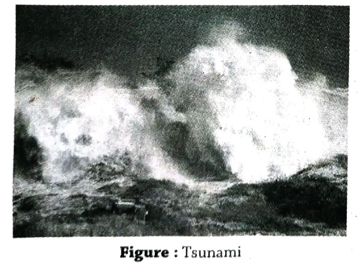
- Landslides: Landslides resulting in rockfalls, andslides or slumps submarine generate tsunamis. For example, movement of a significant amount of earth for the construction of an airport triggered an can underwater landslide in 1980 in southern France. This resulted in a devastating tsunami hitting the harbour of Thebes.
- Eruption of volcano: Volcanic eruptions can generate waves as a result of sudden displacement of water giving rise to tsunami. For example, one of the most devastating tsunamis ever recorded on August 26, 1883 after the explosion and collapse of the Krakatoa in Indonesia.
- Extraterrestrial collision: Although tsunamis caused by extra-terrestrial collisions such as meteors and asteroidsinduced tsunami have not been recorded in recent history and the possibilities are rare, but tsunamis may be generated by such extra-terrestrial collisions.
- Physical changes: Tsunami may result in various physical changes. For example, the islands of Andaman and Nicobar experienced widespread devastation because of a tsunami in 2004. Some smaller islands in the Nicobars have entirely vanished and some others have changed shape, such as Trinket which has been split into two parts after the tsunami.
- Change in soil characteristics: Tsunami may result in a change in the characteristics of soil, especially soil salinity. The coastal regions are bounded by vast expanses of salty, marine waters and thus the salinity of the soil may increase at certain times. This may negatively effect soil fertility and productivity.
- Damages the marine ecosystem: Tsunamis cause great damage and even devastation to marine ecosystem.
- Shortening the length of the day: The massive earthquake that struck Sumatra in 2004 has shortened the length of earth’s day. The intense tremor of 9.1 magnitude has accelerated the spin of the earth, shortening the length of the 24 hours day by 6.8 microseconds.
- Casualties: Tsunamis are generally very devastating and cause huge loss to life of human and animals. The tsunami waves in the morning hours of December 26, 2004 around Bay of Bengal caused an official death toll of 812 and unofficial death toll is estimated to be about 7,000.
- Damage to property: Tsunamis generally cause great damage to property, especially in the coastal regions. Huge loss of houses, roads, agricultural fields, factories are caused by tsunami.
- Strength of wind: Winds that are at least 56 kilometre per hour or greater than the normal snowstorm are identified as blizzards.
- Visibility: The visibility is reduced to almost 400 metre or even to zero at times.
- Duration: Most blizzards last for a duration of almost 3 hours.
- Physical illness: The extreme cold winds during blizzards are a cause of great discomfort to the local people which may subsequently lead to physical illness and may even cause hypothermia. Such as, in 1972, four thousand people were died due to the effect of blizzard in Iran.
- Disrupts transport system: The thick layers of snow that accumulate during blizzards may disrupt the local transport system. Blizzards paralyse the transport system and leave the roads in an unsafe condition. For example, from March 11 to 14, 1888, a blizzard dumped an average of 1 metre of snow over south-east New York and southern part of New England. It killed over 400 people, of which New York City alone recorded 200 deaths.
- Flood: The sudden rise in temperature that may follow a blizzard can prove to be damaging as the rapid snow-melt water may trigger serious floods and other fatal accidents.
- Disrupts public life: Blizzards generally disrupt public life by interrupting transport, electricity and water supplies and also normal day-to-day life by interrupting health and educational facilities.
- Plate tectonics: The earth’s crust is divided into a number of tectonic plates moving in different directions and at different speeds. At convergent plate boundary the plates Imove towards each other, at divergent plate boundary the plates move away from each other and at transform plate boundary the plates slide past each other horizontally. These boundaries are geologically active and the movement of the plate gives rise to occurrence of volcanoes.
- The buoyancy of the magma: As a rock inside the earth melts, its volume increases, producing magma that is less dense than the surrounding rock. This lighter magma rises up because of its buoyancy. Since the density of the magma between the zone of its generation and the surface is less than. that of the surrounding and overlying rocks, the magma will reach the surface and erupt.
- The pressure from the dissolved gases in the magma: Magma contains dissolved volatiles like water, sulphur dioxide and carbon dioxide. The amount of dissolved gases in magma at atmospheric pressure is zero, but rises with increasing pressure. When magma moves toward the surface, the solubility of the water in the magma decreases, and excess water separates from the magma as bubbles. The closer it gets to the surface, more water comes from the magma, increasing the gas and magma ratio in the magma tube. When the volume of bubbles reaches about 75%, the magma turns into partially molten and solid fragments and it erupts explosively.
- Injection of new magma into an already filled magma chamber: As an additional amount of magma enters a chamber that is already at its full capacity, the new magma causes some of the existing magma to move to the surface and erupt.
- Release of energy: A volcanic event occurs when there is a sudden or continued release of energy caused by magma movement near the surface. The energy can be in the form of earthquakes, gas emission at the surface, release of heat through geothermal activity, explosive release of gases and the non-explosive extrusion or intrusion of magma.
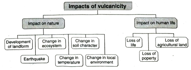
- Impact on nature: Vulcanicity impacts on nature in various ways-
- Development of landforms: Different types of landforms like caldera, cinder cones, lacolith, dykes, sills, etc., are formed due to vulcanicity.
- Earthquakes: When explosions take place during volcanic eruptions on a massive scale, earthquakes may be felt in the adjoining areas.
- Change in ecosystem: The ecological balance of the affected area is disturbed as many species of plants and animals become endangered.
- Change in temperature: The temperature of the surrounding areas of a volcanic eruption increases.
- Change in soil character: Soil characteristics get changed as lava spreads across the land.
- Change in local environment: Local environment is considerably changed. For example, there is a possibility of acid rain as a reaction of toxic gases released during vulcanicity.
- Impact on human life: Vulcanicity also effects on human life-
- Loss of life: A massive loss of life occurs as a result of vulcanicity. For example, about 3600 people died in the coastal areas of Java when the Krakatoa volcano erupted in 1883.
- Loss of of property: Huge loss properties like buildings, transport network, industries occurs and the economic life of the whole region is being affected.
- Loss of agricultural land: Large tracts of land are rendered infertile as a result of being covered by hot molten lava gushing out of the volcanoes. For example, the famous Barren Island of Andaman and Nicobar.
- Slope of the land: It has been observed that avalanches are a common occurrence on slopes ranging from 35° – 45° and concave slopes are more favourable than convex slopes of the mountain.
- Excessive snowfall: Avalanches are influenced by the amount of snow or ice on. the mountain tops. Excessive snowfall increases the posibilities of avalanches.
- Smoothness of slope: In comparison to forested or vegetated slopes, bare and smooth slopes act as a trigger for avalanches.
- Size of ice crystals: Since bigger ice crystals are weak and break easily, they are more prone to initiate an avalanche compared to compacted or packed ice.
- Sun rays: Since the sun’s rays warm up the ice, they lead to avalanches.
- Wind flow: Winds blowing from varying directions loosen up the ice and initiate an avalanche.
- Human interference: Human activities such as cutting down of trees, construction of roads, explosion by dynamite, ice-sports etc., increase the possibilities of avalanches.
- Melting of the snow: Sun rays warm up the snow on the hill slope and thus the snow gradually melts. As a result avalanches occur and melted snow moves down the slope.
- Earthquake: Earthquake causes crack in the snow which results avalanches.
Short Answer Type Questions
Multiple Choice Type Questions [MCQ type]
Write the correct answer from the given alternatives
Very Short Answer Type Questions
Fill in the blanks with suitable words
If the statement is true, write ‘T’ and if false, write ‘F’ against the following
Answer in one or two words
TOPIC – B
Disaster Management
Short Explanatory Answer Type Questions
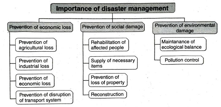
1. Prevention of economic loss:
- Prevention of agricultural loss: The fertility of the land diminishes and salinity of soil may also increase as a result of floods, droughts, earthquakes etc. Proper infrastructure can be developed for cultivation of crops if forecast of any disaster is made.
- Prevention of industrial loss: Various industrial products and infrastructure are damaged which can be restored by undertaking proper disaster management programmes.
- 3 Prevention of economic loss: The economy of any region is hampered as a result of loss in agricultural and industrial sectors due to natural calamities. Appropriate disaster management measures can be taken reduce such economic losses.
- Prevention of disruption of transport system: When the transport system is disrupted due calamities like, landslides, earthquakes etc., alternative modes of transport can be arranged to alleviate the problem.
2. Prevention of social damage:
- Rehabilitation of affected people: A damaged area can be restored to its original normal state by acting on an emergency basis and on a war-footing. For example-rapid action taken for rescuing people and rehabilitating them would be of immense help.
- Supply of necessary items: Supply of necessary items like food, water, shelter, etc., is possible through the aids by state and central governments.
- Prevention of loss of property: If a warning is issued prior to the disaster, much of the damage caused to life and property can be minimised.
- Reconstruction: Disaster management also helps to rebuilt properties (like houses, buildings, etc., quickly that are damaged.
3. Prevention of environmental damage:
- Maintenance of ecological balance: By adopting appropriate measures of disaster management, the damage incurred to the environment can be reversed.
- Pollution control: Disaster management helps to control pollution. For example-Afforestation along the bank of a river helps to prevent erosion of soil and their subsequent sedimentation of river beds. As a result, floods are prevented and eventually soil pollution is controlled. Beside that, planted trees help to control air pollution.
- Preventive measures: Even before the actual disaster occurs there are some prior measures that can be taken to reduce the intensity of the disaster. Such as- (1) Conducting awareness programmes, (2) Compiling suitable laws, (3) Conducting proper regional surveys and preparing maps, (4) Forecast of the disaster can be transmitted through radio and television channels to the common people.
- Remedial measures: These measures are taken once the disaster has hit a region. There are two stages of remedial measures- (1) The first stage involves rescue and recovery of the affected people. and provide them with relief facilities like food, medicine, clothing, temporary houses and such others. (2) The second stage involves working towards recovery in order to lessen the impact of disasters and revert to normal conditions. The measures taken under this stage are re-establishing the communication systems, rebuilding the roads, houses, schools and working towards supply of electricity, safe drinking water.
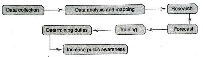
- Data collection: Data related to causative factors of disasters should be collected. For example In the case of floods and droughts, rainfall data of past few years should be taken.
- Data analysis and mapping: The collected data is then analysed to determine the intensity and extent of the disaster and mapping is done on the basis of analysed data.
- Research: After mapping, a thorough research is undertaken in order to assess the past as condition and future predicaments.
- Forecast: If proper forecast is done through data analysis using modern technology, the amount of loss or damage caused by any disaster can be minimised.
- Training: Training can be imparted to all including common people, army personnel etc., by the authorities at the centre, state and district levels so that the loss and damage incurred in a disaster is minimal.
- Duty distribution: After proper training, duties and responsibilities are determined for all the people. It helps to prevent disaster and also helps to deal with it.
- Increase public awareness: Steps should be taken for increasing public awareness and precautionary measures should be taken.
- Rescue operations: These are undertaken on an emergency basis by both the local people and army personnel in order to save maximum number of people and animals.
- Relief operations: Relief materials are distributed to the people of the affected area by central and state government agencies and the extent of loss and damage is estimated. Preventive measures are taken to control further deterioration of the situation. Medicines, food and safe drinking water are also provided to the affected people.
- Temporary shelter arrangements: If the intensity of disaster gradually increases, necessary steps should be taken to shift the disaster striken people quickly from the disaster affected areas to safe and secure places. Besides, security arrangements also have to be made for the prevention of theft, looting, etc. in disaster affected areas.
- Rehabilitation: Normal life can be restored by providing aid and making arrangements for reconstruction of damaged houses, roads, transport and other civic amenities and services including agricultural and industrial establishments. Temporary shelters have to be made on an urgent basis.
- Reconstruction: A host of measures can be taken, like planning different projects and creating jobs in different sectors, to normalise the economic condition of the affected people. For example-in droughtprone areas, watershed projects, irrigation projects etc., can aid in reducing the chances as well as the impact (where a disaster has already taken place) of such disasters.
- The Darjeeling-Himalayan region: This region frequently experiences landslides and floods.
- The Sunderban region: This region frequently experiences tropical cyclones and floods.
- The plateau region: The areas under Purulia, Paschim Medinipur, Bankura, Purba and Paschim Bardhaman and western part of Birbhum fall under the plateau region. This region frequently experiences the wrath of droughts.
- The plain region: The plain region consists of the areas that are situated on the bank of river Ganga or near the Ganga plain in West Bengal. These region experience heavy monsoon and thus are prone to flood.
- Less human interference in the land: If climatic conditions change naturally, rainfall intensity decreases and as a result, there would be lesser floods. 2 Watershed management and proper drainage system, afforestation, changing the slope by constructing terraces, control of overgrazing, contour-farming etc., can check the occurrence of floods.
- Barrage construction and dredging: (1) Construct barrages and reservoirs to store excess water of rivers, (2) construct dykes or dams across rivers at specific locations in order to prevent flooding of low-lying areas, (3) regular dredging of the river bed is needed to lower the level of silt for smooth flow of river water.
- Proper planning: (1) Implementation of strict laws to bar construction of houses etc., in flood-prone areas along rivers, (2) dredging and reclaiming dead and decaying rivers, (3) increasing public awareness through propaganda and advertisements- by these methods, losses incurred due to floods can be reduced.
- Conservation of water: Conservation and appropriate use of water is necessary to prevent drought.
- Recharge of groundwater: To keep the water supply intact throughout the year, groundwater reservoirs should be recharged properly. Seepage from the ponds and reservoirs can help to recharge the groundwater storage.
- Dry farming: To stop the excess use of water in agriculture and to prevent droughts, dry-farming should be practiced. Use of drought-resistant seeds should be encouraged.
- Rain water harvesting: Collection and storage of rain water from a roof-like surface and using it properly for irrigation and other domestic purposes is known as rain water harvesting. It helps to recharge ground water reservoirs that prevent drought.
- Stop the wastage of water: Wastage of water in various ways must be checked. It helps to conserve water and also prevent drought.
- Other measures: Some other measures that should be taken to prevent drought are – (1) Construction of artificial reservoirs, (2) Increase the efficiency of irrigation that reduces water wastage, (3) arrange proper distribution of relief to drought-hit victims, etc.
1. Pre-disaster stage:
- Evaluation of risk: The students must have an idea of the area in which they reside and how much it is prone to a disaster. They should aware their neighbours and all the members of their family.
- Spread of awareness: Any place or area can experience a disaster, hence mock-drills must be done to make people aware about what measures can be taken to combat it. For example-If any area is prone to flood, how should people reach higher grounds to save themselves, what types of food and medicines they should carry with them, etc., must be rehearsed.
- Arranging the essential documents: Disasters like flood, cyclone, earthquake are sudden events. So, students should keep their essential documents like voter cards, adhaar cards, pan cards, results and certificates, bank documents, etc. close by at the time of quick escape.
- Early warning: If the students get the warning beforehand, they can not only prepare themselves, but can also warn their neighbours at the same time.
- Taking stock of available infrastructure: The students can learn from their teachers the names and addresses of those government and nongovernmental organisations and agencies, which usually provide relief, evacuation, rehabilitation measures, etc. Students have to make a list of certain properties that may be used as safety shelters in the wake of a disaster. For example-suitable buildings and schools for converting them into relief camps, dry food, torch and other emergency articles like medicines, etc.
2. During disaster stage:
- Going to any rescue centre: Students should go to any rescue centre or safe place with their family and neighbours during the disaster period.
- Not keeping the electric, water and gas connections open: Students should not keep the gas and water connections open and should turn off the power switches of their houses during the disaster period.
- Sheltering in right place: During disaster like earthquake students should leave the house and move to any open place with their family members. If, at home, they can take shelter beneath any sturdy furniture like a table, bed etc.
- Not listening to rumours: Students should stay away from any kind of rumour that may cause violence or any other problem.
3. Post-disaster stage:
- Contact proper organisations: During the urgent need for providing relief (in the form of food, water, medicines, clothes, temporary shelters, etc.), students have to contact the relevant organisations which provide these in order to accelerate the relief process.
- Take part with rescue operators: Students should work hand in hand with the professional rescue operators.
1. Measures for cyclone and flood
- Exact forecasting: Nowadays, proper forecasting of disasters, like cyclone, flood, etc. in West Bengal is easy due to the obtained data from Satellite images.
- Construction of rescue centres: Multipurpose rescue centres have been constructed near large settlements in disaster prone areas.
- Storage of essential logistics in district headquarters Before rainy seasons essential materials like tarpaulins, plastic, ropes, boats, dry foods, medicines are stored in district headquarters.
2. Measures for droughts:
- Installation of new tubewells and repair of old tubewells: Old tubewells have been repaired and government has taken a plan to install new tubewells in drought prone areas.
- Cultivation of drought resistant crops: To prevent drought conditions> farmers have been encouraged to cultivate drought resistant crops in West Bengal.
- Development of irrigation system: To develop irrigation system old canals have been repaired and new canals are being dug in the drought prone areas in West Bengal.
3. Other disaster preventing measures:
- Formation of a central committee: A central committee has been formed joining the various departments of Government of West Bengal to manage disasters.
- Provide financial help: Various plans have been taken to provide financial helps to the people below poverty level of the disaster prone area.
- Application of local techniques: People have been encouraged to apply local techniques to tackle disasters at the time of disasters.
- Spreading awareness: Government of West Bengal has taken different awareness programmes to make people aware about disasters through radio, television, news papers and other media.
Short Answer Type Questions
- Districts of North Bengal: Cooch Behar, Jalpaiguri, Malda, Uttar and Dakshin Dinajpur.
- Districts of South Bengal: Nadia, Howrah, Murshidabad, North and South 24 Parganas, Hooghly, Bardhaman, Birbhum, Paschim Medinipur and Purba Medinipur.
Multiple Choice Type Questions [MCQ type]
Write the correct answer from the given alternatives
Very Short Answer Type Questions
Fill in the blanks with suitable words
If the statement is true, write ‘T’ and if false, write ‘F’ against the following
Answer in one or two words
Follow on Facebook page – Click Here
Google News join in – Click Here
Read More Asia News – Click Here
Read More Sports News – Click Here
Read More Crypto News – Click Here