WBBSE 9th Class Social Science Solutions Geography & Environment Chapter 8 West Bengal

WBBSE 9th Class Social Science Solutions Geography & Environment Chapter 8 West Bengal

West Bengal Board 9th Class Social Science Solutions Geography & Environment Chapter 8 West Bengal

WBBSE 9th Class Geography & Environment Solutions

Salient points – At a Glance

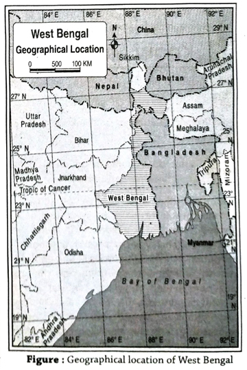
  1. West Bengal is the only state of India which extends from the Bay of Bengal to the Himalayas.
  2. At present, there are 28 states and 8 union territories in India.
  3. West Bengal ranks fourth in total population and second in population density among the 28 states of India.
  4. West Bengal shares common boundaries with three independent countries namely, Bangladesh, Bhutan and Nepal and five Indian states namely, Assam, Sikkim, Bihar, Jharkhand and Odisha. Though the state of Tripura does not share a common boundary with West Bengal, yet it is regarded as a neighbouring state of West Bengal.
  5. Presently, there are 23 districts in West Bengal which are grouped into 5 administrative divisions- (1) Jalpaiguri division, (2) Malda division, (3) Bardhaman division, (4) Medinipur division, (5) Presidency division.
  6. The most newly formed districts of West Bengal are Purba Bardhaman and Paschim Bardhaman which were formed on 7 April 2017 after the bifurcation of the former Bardhaman district.
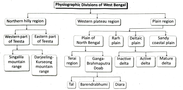
  7. West Bengal is mainly divided into three physiographic divisions- (1) Northern hilly region, (2) Western plateau region and (3) Plain region.
  8. Northern hilly region of West Bengal is the extended part of eastern Himalayas. This mountainous region covers the major part of Darjeeling district except Siliguri subdivision, Kalimpong district and northern part of Alipurduar district.
  9. Singalila range extends along the boundary of Darjeeling and Nepal. Sandakphu, one of the peaks of Singalila range (3665 m) is the highest peak of West Bengal.
  10. The plain land at the foothills of northern hilly region is known as Terai. The slope of the land is from north to south. The land at the east of Terai is known as Dooars or Duars.
  11. Geologically western plateau region is a part of the Chotanagpur Plateau.
  12. Gorgaburu of Ayodhya hill is the highest peak (677 m) of western plateau region.
  13. Old alluvium region of North Bengal is called Barind or Barendrabhumi. Red soil can be seen in this region.
  14. Scattered marshy land of northern plain is locally known as Tal.
  15. The flat land between the western plateau region and Bhagirathi-Hooghly river is known as Rarh region.

TOPIC – A

Location and Administrative division of West Bengal

Long Answer Type Questions

1. Describe the restructuring of West Bengal after independence of India.
Ans. Restructuring of West Bengal after independence: There was no state known by the name of West Bengal before India’s independence on August 15, 1947. At that time, undivided Bengal was known as ‘Bangadesh’. The different stages of evolution of the administrative regions of West Bengal from the previous Bangadesh are mentioned below-
  1. In 1947 when India was divided, Bengal was divided too. One-third of the land area of Bengal formed West Bengal, while the rest went on to form East Pakistan. The Boundary Commission was formed in 1947 under the leadership of the English lawyer Radcliff Brown. He marked the boundary between West Bengal and Bangladesh.
  2. Religion was the major basis of the partition of Bengal. The majority non-Muslims formed West Bengal and Bangladesh was formed where Muslim community was the majority. At that point of time in 1947, the total area comprising West Bengal was 78,000 sq. km.
  3. The Islampur sector of Bihar was annexed to the district of West Dinajpur of West Bengal in 1947.
  4. The French colonies of Chandannagar and Gaurhati were included in West Bengal.
  5. The Mahananda Corridor was formed after including the Bengali-speaking region of eastern Purnea district of Bihar (in accordance with the law of re-construction of states).
  6. A self-governed region of Darjeeling Gorkha Hill Board (‘Parshad’) was formed including the hilly region of Darjeeling district of West Bengal in 1988.
  7. In 1986, the 24 Parganas district of West Bengal was divided into two districtsNorth 24 Parganas and South 24 Parganas.
  8. In 1992, the district of West Dinajpur was divided as Uttar Dinajpur and Dakshin Dinajpur. The corridor named ‘Teen Bigha’ was leased to Bangladesh, that included the district of Cooch Behar, the bordering regions of Makaliganj and Kuchilbari.
  9. In 2002, the district of Medinipur was divided into two districts-Paschim Medinipur and Purba Medinipur.
  10. The latest change in the administrative boundary of West Bengal was the formation of Alipurduar district (from the Jalpaiguri district) on 25 June 2014.
  11. Kalimpong district was formed from Darjeeling district on 14 February, 2017.
  12. Jhargram district was formed from Paschim Medinipur district on 4 April, 2017 and Purba and Paschim Bardhaman districts were formed on 7 April, 2017 by splitting the Bardhaman district.
2. Write about the neighbouring countries and states of West Bengal.
Ans. Neighbouring countries of West Bengal:
  1. Nepal: It is located to the north-west of West Bengal with a total area of about 147181 sq.km. The capital of Nepal is Kathmandu. The world’s highest peak, Mt. Everest (8848 m) is located in Nepal. The main river of this country is Kaligandaki.
  2. Bhutan: Bhutan is located to the north of West Bengal with an area of about 38394 sq.km. Its capital is Thimphu. The highest peak of Bhutan is Kula Kangri and its longest river is Manas.
  3. Bangladesh: Bangladesh is located on the eastern side of West Bengal. Its area is 148460 sq. km. Dhaka is the capital of Bangladesh. The highest peak of Bangladesh is Keokradong and its longest river is Padma-Meghna.
Neighbouring states of West Bengal:
  1. Bihar: Bihar is located to the west of West Bengal. Its area is 94163 sq. km. The capital of Bihar is Patna. Besides Ganga (which is the main river of Bihar), other rivers which flow through this state are Kosi, Gandak, Son, etc.
  2. Jharkhand: It is located on the western side of West Bengal covering an area of 79714 sq. km. Its capital is Ranchi. The main river of this state is Mayurakshi. Jharkhand is also called the ‘Mineral State of India’.
  3. Assam: It is located to the east of West Bengal and its total area is 78438 sq. km. The capital of Assam is Dispur. The main river here is Brahmaputra. The famous Majuli island, which is the largest riverine island in the world has formed over this river.
  4. Odisha: It is located to the south-western side of West Bengal with an area of 155707 sq. km. Its capital is Bhubaneshwar. The main river of this state is Mahanadi. Puri is a famous religious as well as tourist centre of Odisha.
  5. Sikkim: It is located on the northern part of West Bengal covering an area of 7096 sq. km. Its capital is Gangtok. The highest peak of Sikkim is the Kangchenjunga and the longest river is Teesta.
3. Discuss the importance of West Bengal as a state.
Ans. Importance of West Bengal as a state: West Bengal has immense importance as a state because of the following reasons-
  1. Area: West Bengal comprises about 2.7% of the total area of India.
  2. International border: West Bengal shares international border with Bangladesh, Nepal and Bhutan. Pertaining to the length of international border, West Bengal ranks second in India.
  3. Population: In terms of population, West Bengal ranks fourth in the country and comprises about 7.5% of the total population of India.
  4. Population density: West Bengal has the second highest population density (1029 persons per sq. km) just after Bihar.
  5. Agricultural production: Among all the states of India, West Bengal occupies the top position in production of rice, jute and fish. In case of potato and tea production, West Bengal ranks second whereas for coal. mining, it occupies the seventh position.
  6. Industry: West Bengal has a significant position in case of iron and steel industry, engineering industry and tea industry.
  7. Commercial position: Kolkata, the capital of West Bengal, is the second largest city in India (in terms of population). Apart from this, it is also the largest commercial centre in eastern India. Kolkata has the largest commercial port and an international airport.
  8. Diverse physical features: West Bengal is the only state in India where both the Himalayan mountain range and the Bay of Bengal are found. Apart from these, flood plains, plateaus, rivers & islands are also found here.

Short Explanatory Answer Type Questions

1. Write a note on the location of West Bengal. 
Ans. Importance of West Bengal as a state: West Bengal has immense importance as a state because of the following reasonsWest Bengal is a state located in the eastern region of India. In terms of area, West Bengal holds the 14th position among the 28 states in India. The latitudinal extent of the state is 21°38’N from the south to 27°10’N to the north whereas the longitudinal extent is 85°50’E from the west to 89°50’E to the east. The Tropic of Cancer passes across the districts of Nadia, Purba Bardhaman, Bankura and Purulia. From north to south, West Bengal extends about 650 km, and from west to east, it extends about 325 km. West Bengal is surrounded by land on three sides and by sea on one side. West Bengal shares its boundary with Sikkim and Bhutan in the north. It is bounded by Bangladesh in the east, Assam in the north-east, Bay of Bengal in the south, Odisha in the south-west, Nepal in the ‘north-west and Jharkhand and Bihar in the west.
2. What is the significance of the geographical location of West Bengal?
Ans. West Bengal is located in the eastern side of India. The Himalayas are located to the north and Bay of Bengal to the south of West Bengal. The geographical location of West Bengal is significant in many ways-
  1. The cold winds from the northern part are not able to reach West Bengal because of the location of Himalaya which acts as a barrier in the north. It also protects us from foreign invasion.
  2. The Bay of Bengal, located to the south of West Bengal protects the state from foreign invasion and also helps in international trade. The Kolkata and Haldia ports play a vital role in carrying out trade via sea.
  3. The seasonal variation and rich biodiversity of West Bengal are a result of its geographical location.
3. What do you mean by municipality and municipal corporation?
Ans. Like the other states of India, all autonomous institutions of West Bengal are divided into two categories- (1) Rural and (2) Urban. Panchayat is a rural autonomous institution. Municipalities have been established in small and medium town whereas the large cities are under municipal corporations. At present, number of municipalities and municipal corporations in West Bengal are 130 and 6 respectively. The six municipal corporations are-Kolkata, Howrah, Asansol, Durgapur, Siliguri and Chandannagar.
4. Give an idea about the Zilla Parishad in West Bengal.
Ans. The panchayat system in West Bengal is a three-tier system in which the topmost tier is Zilla Parishad at the district level (according to the West Bengal Panchayat Act). The state government has formed a Zilla Parishad for each district according to their name except for Darjeeling district. A Zilla Parishad is formed by the following members- (1) President of Panchayat Samiti of respective districts, (2) members elected by the voters of each block, and not exceeding three, (3) members of Lok Sabha and legislative assembly from the respective districts, except elected ministers from the district, (4) Rajya Sabha members who are also the voters in their respective districts but not ministers.
5. Briefly write about the Panchayat Samiti in West Bengal.
Ans. According to the West Bengal Panchayat Act, 1973, Panchayat Samiti is the second tier of the Panchayat system. There is a Panchayat Samiti in every block. Each block is developed by the aggregation of some villages. According to Panchayat Act, the overall responsibility of block development is entrusted to the Panchayat Samiti. The state government names the Panchayat Samiti according to the name of the block. Panchayat Samiti is formed by the following members – By virtue of their positions, heads of the panchayat within a block become members of the Panchayat Samiti, Not more than 3 members of every gram panchayat area within a block are elected by the electoral committee.
6. Give an idea of Gram Panchayat in Grama West Bengal.
Ans. The lowest level of the three-tier Panchayat System is Gram Panchayat. According to Panchayat Act, 1973, a village (gram) constitutes of a single mouza or multiple mouzas along with their adjacent areas. The state government will form a Gram Panchayat as per the name of the village. Voters of every village elect the members of the Gram Panchayat. The number of elected members in a Gram Panchayat may be a minimum of five and a maximum of twenty five. Head of a Gram Panchayat is head of the Panchayat.

Short Answer Type Questions

1. What were the earlier administrative divisions of West Bengal?
Ans. The three earlier administrative divisions of West Bengal were- (1) Presidency division, (2) Bardhaman division, (3) Jalpaiguri division.
2. Write about the subdivision and block administration of West Bengal.
Ans. West Bengal is divided into 23 districts for conducting the administrative activities properly. Each district is divided into a number of sub-divisions. A Sub-Divisional Officer (SDO) is in charge of each sub-division. Further, each sub-division is divided into a number of blocks. Head of the block administration is called Block Development Officer (BDO). BDO works under the supervision of SDO.
3. What are the administrative divisions of West Bengal?
Ans. West Bengal is divided into five administrative divisions namely – (1) Jalpaiguri division, (2) Malda division, (3) Burdwan division, (4) Medinipur division and (5) Presidency division.

Multiple Choice Type Questions [MCQ type]

Write the correct answer from the given alternatives

1. The number of districts in West Bengal is-
A. 17
B. 18
C. 19
D. 23
Ans. D
2. The state which shares the longest border with West Bengal is-
A. Bihar
B. Jharkhand
C. Odisha
D. Assam
Ans. B
3. The latitude that extends over Krishnanagar of Nadia district is-
A. O⁰
B. 23½° N
C. 23½° S
D. 30° N
Ans. B
4. A state which lies to the north of West Bengal is-
A. Sikkim
B. Tripura
C. Bihar
D. Odisha
Ans. A
5. The state of West Bengal was formed in-
A. 1951
B. 1947
C. 1949
D. 1956
Ans. B
6. The number of bordering states of West Bengal are-
A. 2
B. 3
C. 4
D. 5
Ans. B
7. Chandannagar was included in West Bengal in the year-
A. 1956
B. 1968
C. 1952
D. 1954
Ans. D
8. Cooch Behar became a part of West Bengal in-
A. 1950
B. 1952
C. 1954
D. 1947
Ans. A
9. The state which lies to the south-west of West Bengal is-
A. Bihar
B. Arunachal Pradesh
C. Odisha
D. Jharkhand
Ans. C
10. The latitude which forms the northern limit of West Bengal is-
A. 28°02’N
B. 21°30’N
C. 27°10’N
D. 20°30’N
Ans. C
11. The latitude which forms the southern limit of West Bengal is-
A. 21°38’N
B. 21°22’N
C. 27°10’N
D. 27°05’N
Ans. A
12. The number of districts in the Presidency division of West Bengal is-
A. 7
B. 9
C. 8
D. 5
Ans. D

Very Short Answer Type Questions

Fill in the blanks with suitable words

1. West Bengal was founded on ……..
Ans. 15 August, 1947
2. Siliguri is known as the …….. of India.
Ans. North-east Gateway
3. …….. district is the ‘Crown of West Bengal’.
Ans. Darjeeling
4. Burdwan division of West Bengal has ……… districts..
Ans. 4
5. From north to south West Bengal extends for about ……… km.
Ans. 650

If the statement is true, write ‘T’ and if false, write ‘F’ against the following

1. Bangladesh lies to the west of West Bengal.
Ans. F
2. The highest peak of Darjeeling district is Gorgaburu.
Ans. F
3. Haryana is a neighbouring state of West Bengal.
Ans. F
4. The Jalpaiguri division of West Bengal has five districts.
Ans. T
5. In the northern part, Bihar is one of the most important neighbouring states of West Bengal.
Ans. F
6. West Bengal has 19 districts at present.
Ans. F
7. The second largest neighbouring country of West Bengal is Bangladesh.
Ans. F
8. Ayodhya hill is located in Purulia.
Ans. T
9. Kathmandu, the capital of Nepal, is an important tourist place.
Ans. T

Answer in one or two words

1. What is the total area of West Bengal?
Ans. 88752 sq. km.
2. Which are the newly formed districts of West Bengal?
Ans. Purba Bardhaman and Paschim Bardhaman (7 April 2017).
3. Which district in West Bengal occupies the largest area?
Ans. South 24 Parganas.
4. How many districts does West Bengal have?
Ans. 23 districts.
5. What is the percentage of West Bengal’s area with respect to that of India?
Ans. 2.69%.
6. In which year was Alipurduar formed?
Ans. 2014.
7. What is the capital of Jharkhand?
Ans. Ranchi.
8. What is the capital of Assam?
Ans. Dispur.
9. In which year was Medinipur classified into two administrative divisions?
Ans. January 1, 2002.

TOPIC – B

Physiography

Long Answer Type Questions

1. Discuss about the physiographic divisions of West Bengal. Or, Give an account of the physiography of West Bengal.
Ans. Physiographic divisions of West Bengal: The physiography of West Bengal is very diverse. Based on the physiography, West Bengal can be divided into the following groups and subgroups-
Northern hilly region:
Location: The entire districts of Darjeeling (except, Siliguri subdivision) and Jalpaiguri along with the northern part of the Alipurduar district fall under the Northern hilly region.
Characteristics: The main characteristics of Northern hilly region are-
  1. This region is a part of the Eastern Himalayas.
  2. The average height of this region is approximately 2600m-2700 m.
  3. The northern hilly region has several canyons and high peaks and so is inaccessible in general. The slope of this region is from north to south.
Physiography: Teesta river flows from north to south over the region and divides this region in two parts. These are as follows
  1. The western part of Teesta: The western part of the Teesta river has two important Himalayan mountain ranges- (1) Singalila mountain range and (2) Darjeeling-Kurseong mountain range. Three main peaks of Singalila mountain range are located in the Darjeeling district. These areSandakphu (3630 m, the highest peak of West Bengal), Phalut (3596 m) and Sabargram (3543 m). In the Darjeeling-Kurseong mountain range, one of the most prominent peak is Tiger Hill (2573 m). Another notable peak of this range is Senchal (2615 m).
  2. The eastern part of Teesta: The average elevation of the mountain range in eastern part of Teesta river is comparatively less. The highest peak in this region is Rishila (3121 m). Apart from this, other peaks in this region are Renigango (1885 m), Sanchuli (1726 m) etc. The Buxa-Jayanti Hills, Durpin Dara Ridge are also located in the eastern part of Teesta river.
Western plateau region:
Location: The entire districts of Purulia, Paschim Medinipur, Bankura, Paschim Bardhaman and the undulating western part of the Birbhum district constitute the western plateau region.
Characteristics: The main characteristics of this region are-
  1. The average elevation of western part of this plateau region is higher (600 m) than that of the eastern part (100 m).
  2. The land here is rocky and full of pebbles.
  3. The region is mainly composed of granite and gneiss rocks. However, some parts of the plateau region is also made of rocks like sandstone, shale, etc.
Hills: This area has many low hills, such as, Ajodhya Hills, Baghmundi Hills, Panchet Hills of Purulia district; Biharinath Hills, Susunia Hills of Bankura district; Mama-Bhagne Hills of Birbhum district. The highest peak of this plateau region is Gorgaburu (677 m) in the Ajodhya Hills.
Plain Region:
Location: Except the northern hilly region and the western plateau region, the remaining area of West Bengal falls under the plain region.
Characteristics: The main characteristics of this region are-
  1. The elevation of this region is not very high.
  2. This region has formed by the deposition of silt carried by rivers.
Division: The plain region can be further divided into the following way-
  1. Plain of North Bengal: This plain region extends from the foothills of the Darjeeling Himalayas in the north to the left bank of the Ganga river in the south. The slope of this region is from north to south. In the north the foothills of the Himalayan range is called the Terai and the remaining region is called Ganga-Brahmaputra Doab. This region is known by different names in different areas. For example, the low-lying regions of Jalpaiguri, Cooch Behar, Uttar Dinajpur is known as ‘Tal’, the eastern parts. of the Malda and Dakshin Dinajpur districts, composed of old alluvial soil and laterite soil is called ‘Barendrabhumi’ and the western part of the Malda district composed of new alluvial soil, which is extremely fertile is known as ‘Diara’.
  2. Rarh plain: The intermediate region between the plateau region in the west and Bhagirathi-Hooghly in the east is called the Rarh plain. The eastern parts of Bankura and Paschim Bardhaman; northern and eastern parts of Birbhum; the entire district of Purba Bardhaman, Purba Medinipur, Howrah, Hooghly and western part of Murshidabad fall under the Rarh plains. The western part of this plain region is slightly undulating and red soil is found in that region. The slope of this area is from west to east.
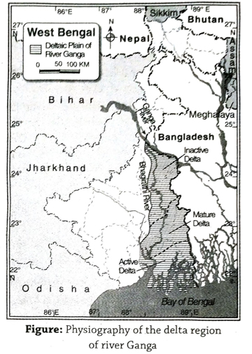
  3. Deltaic plain: The entire districts of Nadia, North and South 24 Parganas, Howrah, Hooghly and the eastern part of Murshidabad district fall under the deltaic plain region. This is a low-lying plain and is a part of the Gangetic deltaic plain. The northern part of this plain is an inactive, delta, the middle part is a mature delta whereas the southern part, i.e., the Sundarbans is an active delta.
  4. Sandy coastal plain: The sandy coastal plain is located along the coast of Bay of Bengal in Purba Medinipur. The slope of this region is from north to south. Many sand dunes are found in this coastal plain.
2. Describe the physiography of the plateau region of West Bengal. 
Ans. The physiography of the plateau region of West Bengal: The physiography of the plateau region of West Bengal is described below:
  1. The entire Purulia district, adjacent districts of Paschim Medinipur, Jhargram, Bankura, Paschim Bardhaman and western part of Birbhum constitute the undulating western plateau region.
  2. From the geological point of view, this area is an extended part of the Chotanagpur plateau region. This is one of the most ancient regions of West Bengal and is made up of mainly old igneous and metamorphic rocks.
  3. The western part of this plateau region is higher than the eastern part. (75 m). The highest peak of this region is Gorgaburu (677 m). The slope of the land here is from west to east.
  4. This plateau region is scattered with isolated which are made of hard rocks. For example, Ajodhya Hills and Baghmundi Hills located in the western part of the Purulia district.
  5. Gorgaburu of the Ajodhya Hills in Purulia is the highest peak of this whole plateau region. Panchet Hills (490 m) is located in the northern part and Bhandari Hills (433 m) is located in the southern part of the Purulia district.
  6. The eastern part of the western plateau gradually slopes down over the districts of Paschim Medinipur, Bankura, Jhargram, Paschim Bardhaman and western region of Birbhum. Small hills like Belpahari in Paschim Medinipur and Susunia Hills (440 m) are located in the Western plateau region.
3. Give an account of the physiography of the various plains of West Bengal.
Ans. The physiography of the various plains of West Bengal:The whole of West Bengal is a plain land except the mountainous region in the north and the plateau region in the west. This vast plain region can be broadly divided into four categories – (1) Plains of North Bengal, (2) Rarh plains, (3) Deltaic plains and (4) Sandy coastal plains.
Plains of North Bengal: The plain region lying between the river Ganga in the south and the Darjeeling Himalayas in the north is known as the plains of North Bengal. This region can be further classified into- 1. Terai or Dooars plains and 2. Ganga-Brahmaputra Doab plain.
  1. Terai or Dooars Plain: (1) This region comprises of the southern part of Alipurduar district, major part of the southern region of Jalpaiguri district and Siliguri subdivision of Darjeeling district. (2) The Himalayas in the north meets the plain here with gentle slope and creates almost a sloping plain-like landform. (3) Scattered mounds of pebbles and rocks and some wetlands are found in this region. (4) This land slopes from north to south. This region receives heavy rainfall and hence remains wet for most part of the year.
  2. Ganga-Brahmaputra Doab Plain: The plain land lying between the rivers Ganga and Brahmapurta is further classified into the following categories-
    1. Tal: The area between the rivers Kalindi and Mahananda in the Malda district and the low-lying area in the districts of Jalpaiguri, Cooch Behar and Uttar Dinajpur is collectively known as ‘Tal’. Numerous wetlands and marshes are seen here.
    2. Barind or Barendrabhumi: The area encompassing the eastern parts of Dakshin Dinajpur and Malda districts which is undulating and is made up of old alluvial soil and laterite soil is known as ‘Barind’ or ‘Barendrabhumi’.
    3. Diara: This area which is composed of new alluvial soil and lies to the south of Kalindi river, flowing along the southwestern part of Malda district is called ‘Diara’.
Rarh plain: (1) The vast expanse of plainland lying between Bhagirathi-Hooghly in the east and the plateau region to the west is known as Rarh plain. (2) Certain regions of the districts of Purba Medinipur, Bankura, Purba Bardhaman, Paschim Bardhaman, Birbhum, Murshidabad fall under the Rarh plain region. (3) The Rarh plains have been formed as a result of the deposition of silt by the rivers Damodar, Ajay and Mayurakshi. (4) The average elevation of this region is higher in the west (75 m) and lower in the east (10 m) and thus it has a general slope from west to east. The western part of this region is slightly undulating and is composed of old alluvial soil.
Deltaic plain: The deltaic plain has the Rarh region to its east and the districts to the south of Ganga, i.e., eastern part of Murshidabad, Kolkata, Nadia, North 24 Parganas and some parts of Purba and Paschim Medinipur constitute this deltaic plain region. On the basis of structural variations, this plain region is further divided into the following categories-
  1. Inactive delta: The northern part of the deltaic plain encompassing the districts of Nadia and Murshidabad is known as inactive delta. This is because the rivers here do not deposit silt anymore and so the process of delta formation has almost ceased to exist. In this region ox-bow lakes, creeks and wetlands are found.
  2. Mature delta: This region stretches from the southern part of the inactive delta to the northern part of the Sundarban region. It comprises of Kolkata, North 24 Parganas, South 24 Parganas, Howrah, Hooghly and some parts of Purba and Paschim Medinipur. The rivers flowing over this region still deposit some amount of silt during floods. Thus, formation of delta continues to some extent.
  3. Active delta: The southern part of South and North 24 Parganas fall under the active delta region. This deltaic region is called active since the rivers of the Sundarbans are still carrying out depositional work, i.e., siltation and thereby help in the process of delta-formation.
Sandy coastal plain: (1) The sandy coastal plain. is located along the Bay of Bengal coast in Purba Medinipur. (2) The slope of this region is from north to south. (3) There are many sand dunes in this region which are known as Kanthi-Digha sand dunes. (4) The average height of these sand dunes is 10-15m. (5) There are marshy lands behind these sand dunes. The Digha dune lies near Bay of Bengal. (6) Digha, a popular sea beach destination is located in the Digha sand dune region.

Short Explanatory Answer Type Questions

1. Why is the Terai region of West Bengal also hown as the ‘Dooars’ or ‘Duars’?
Ans. The word ‘Terai’ means low marshy ground. The sloping foothills in the southern part of the Himalayan range in North Bengal have an abundance of pebbles, wetlands and dense forests. Thus, this region has a wet and damp environment and is called the ‘Terai’ region. On the other hand, the Terai region also serves as the gateway to Bhutan, i.e., the door to Bhutan is the Terai region. For this reason, the Terai region is also called the ‘Dooars’ or ‘Duars’.
2. Why are floods frequent in the Tal’ region?
Or, The plains of North Bengal are etremely flood prone.’ Explain.
Ans. The word ‘Tal’ means lowland or lake. The intermediate region between Mahananda and Kalindi rivers in Malda, whole of Cooch Behar, some areas to the south of Jalpaiguri and some areas to the north of Uttar Dinajpur are low-lying plains, which are termed as ‘Tal’. In this low-lying plains the rivers such as, Mahananda, Kalindi, Jaldhaka, Torsa, etc. flow very slowly, often change their courses and the river-beds of these rivers are quite shallow. Thus, these rivers overflow their banks during the heavy showers in the monsoon season. For this reason, the plains of North Bengal are extremely flood-prone.
3. ‘The western plateau region is rich in mineral resources.’ Explain.
Ans. The western plateau region of West Bengal is rich in mineral resources. Huge amounts of coal, fire clay; moderate quantities of china clay, dolomite, limestone, quartz, apatite, manganese graphite, etc. and small amount of iron ore are found in this region. This plateau is ancient and is an extension of the Chota Nagpur Plateau. Thus, the western plateau region of West Bengal has an abundance of different types of mineral resources.
4. ‘The Gangetic delta region has a high density of population. Explain.
Ans. The Gangetic delta region is one of the world’s most densely populated. regions. The causes of such high density of population are discussed below-
  1. Plain relief: The plain relief is ideal for agriculture as well as transport and communication.
  2. Moderate climate: The moderate climate and adequate rainfall are the causes of high density of population in this region.
  3. Fertile alluvial soil: The soil of deltaic region is made up of alluvial soil (silt) which is very fertile and suitable for agriculture.
  4. Development of transport: The area is covered by an extensive network of railways, roadways.
  5. Job opportunities: This region is welldeveloped in both agriculture and industry and so job opportunities are plenty here.

Short Answer Type Questions

1. What are the main physiographic divisions of West Bengal?
Ans. The main physiographic divisions of West Bengal are- (1) Northern hilly region, (2) western plateau region and (3) plain region.
2. What is Mahananda Corridor?
Ans. The southern part of Jalpaiguri district, southern part of Cooch Behar district, Uttar and Dakshin Dinajpur districts and Malda district together form the plain region of North Bengal. The narrow river valley of the Mahananda river which flows from north to south connects plains of Jalpaiguri and Cooch Behar in the north with the plains of Malda in the south. This narrow valley is called Mahananda corridor.
3. What is Tal?
Ans. In the southern part of Cooch Behar and Jalpaiguri districts and western part of Malda district there are scattered marshes and lowlands which are flood prone regions. These are locally called ‘Tals’ as the word ‘Tal’ means lowland or lake.
4. What is Bhabar?
Ans. The sand, silt, pebbles brought down by the rivers from the Himalayan mountains get deposited in the foothills, giving it a gentle slope. Such a feature is known as the Terai in North Bengal. The rocky land of the Terai region which is covered by forests is known as Bhabar.
5. What is Barendrabhumi?
Ans. In the eastern part of Malda and South Dinajpur, the gently undulating highland formed of laterite soil and old alluvial soil is known as ‘Barendrabhumi’.
6. What is Diara?
Ans. The region in southern part of Malda district, along the banks of the river Ganga which is made up of new alluvial soil and is very fertile is called Diara.
7. What is Bagri?
Ans. The region of the Gangetic delta plain which includes the eastern part of Murshidabad and the entire Nadia and North 24 Parganas districts, where Bhagirathi river and its distributaries do not deposit any silt, i.e., the formation of delta has almost stopped is known as Bagri. This region is also an inactive delta region.
8. Where is the Rarh plain located?
Ans. The intermediate area between the plateau region in the west and Bhagirathi-Hooghly in the east is called the Rarh plain. This region includes the eastern part of Bankura, western part of Murshidabad, eastern part of Paschim Bardhaman, northern and eastern part of Birbhum and the entire districts of Purba Bardhaman, Purba Medinipur, Howrah and Hooghly.
9. Where is the active delta of West Bengal found?
Ans. The active delta of West Bengal is usually found in the southern and eastern parts of South 24 Parganas (i.e., the Sundarbans) and southern part of North 24 Parganas. In this region, the process of delta formation is still going on.

Multiple Choice Type Questions [MCQ type]

Write the correct answer from the given alternatives

1. Sandakphu, the highest peak of West Bengal, is located at an altitude of-
A. 3543 m
B. 3596 m
C. 3665 m
D. 3700 m
Ans. C
2. One of the important peak of Singalila range is-
A. Phalut
B. Tiger Hill
C. Chitrakoot
D. Anaimudi
Ans. A
3. A famous hill in the plateau region of West Bengal is-
A. Raj Mahal
B. Dowhill
C. Baghmundi
D. Chitrakoot
Ans. A
4. Mama Bhagne hill is in the-
A. Bankura district
B. Birbhum district
C. Jalpaiguri district
D. Darjeeling district
Ans. B
5. The newly formed plain land in the southern part of the Mahananda river in Malda district is called-
A. Diara
B. Barendrabhumi
C. Tal
D. Dooars
Ans. A
6. Which of the following is found in the plateau region of Purulia?
A. Ajodhya Hill
B. Susunia Hill
C. Mama Bhagne Hill
D. Mt. Maniratna
Ans. A
7. Biharinath hill is in-
A. Bankura district
B. Birbhum district
C. Malda district
D. Hooghly district
Ans. A
8. Sand dunes are found in-
A. Purulia
B. Bankura
C. Birbhum
D. Purba Medinipur
Ans. D
9. The highest hill in the western plateau region in West Bengal is-
A. Susunia
B. Biharinath
C. Ajodhya
D. Baghmundi
Ans. C
10. The old alluvial highland region of the northern plain in West Bengal is called-
A. Terai
B. Diara
C. Tal
D. Barendrabhumi
Ans. D

Very Short Answer Type Questions

Fill in the blanks with suitable words

1. The ……… mountain divides Nepal from Darjeeling.
Ans. Singalila
2. The highest peak of the Ajodhya hill is ……..
Ans. Gorgaburu
3. The word ‘Terai’ means ……….
Ans. marshy land
4. The word ‘Rarh’ means …….. in Santhali.
Ans. dry rocky land
5. The ………. mountain range lies to the north of West Bengal.
Ans. Himalaya
6. Barendrabhumi is an ………. plain.
Ans. old
7. The highest peak of the western plateau region in West Bengal is ………
Ans. Gorgaburu
8. Southern part of the Bhagirathi river is known as ………
Ans. Hooghly

If the statement is true, write ‘T’ and if false, write ‘P against the following

1. A mountain pass known as Buxa is situated on the northern mountainous region of Alipurduar district.
Ans. T
2. Susunia is the highest hill in the plateau region of West Bengal.
Ans. F
3. The ancient region of South Dinajpur and Malda districts, composed of alluvial soil is called ‘Barendrabhumi’.
Ans. T
4. The northern part of the Ganga delta is called active delta.
Ans. F
5. The plateau region of West Bengal is made of granite and gneiss rocks.
Ans. T

Answer in one or two words

1. Which is the highest peak of West Bengal?
Ans. Sandakhphu (3665 m).
2. What is the meaning of ‘Dooars’?
Ans. Door.

TOPIC – C

River and Water Resources

Long Answer Type Questions

1. Describe the rivers of West Bengal.
Ans. Rivers of West Bengal: The rivers are divided on the basis of source, direction of flow, amount of water carried, type of delta, etc. The divisions are as follows-1. Rivers of North Bengal, 2. Ganga and its tributaries running through the central part, 3. Rivers of the western plateau and Rarh region, 4. Southern Sunderban region and its rivers, 5. Rivers of the sandy areas of the Kanthi region.
  1. Rivers of North Bengal: The rivers of North Bengal are snowfed. They originate from the Himalayan region and flow from north to south according to the slope. The rivers are Teesta, Jaldhaka, Mahananda, Sankosh, Raidak, Torsa, etc.
    1. Teesta: It originates from the Jemu glacier in the Sikkim Himalayas. Teesta is the main river of North Bengal, flows through the districts of Darjeeling and Jalpaiguri and drains into the Jamuna in Bangladesh.
    2. Jaldhaka: It rises from the hilly regions of the Sikkim-Bhutan border and flows through the districts of Jalpaiguri and Cooch Behar before draining into the Jamuna in Bangladesh.
    3. Mahananda: This river rises in the Darjeeling Himalayas, flows south and drains into the Ganga. Balason river is its tributary.
  2.  Ganga and its tributaries running through the central part: The main river of West Bengal is the Ganga. It emerges from the Gangotri glacier near Gomukh in Uttarakhand and traverses a great distance before entering into West Bengal through Dhulian in Murshidabad. Here, the river gets divided into two parts, one is Hooghly river in West Bengal and the other enters as Padma in Bangladesh. The Hooghly river flows south and drains into the Bay of Bengal. The distributaries of Ganga and Padma are Ichamati, Churni, Jalangi, etc.
  3. Rivers of western plateau and Rarh region: These rivers are rain-fed. The slope of the land is from west to east and southeast and the rivers originating from the Chota Nagpur Plateau flow accordingly. The rivers of this region are-Damodar, Dwarkeswar, Shilabati, Kangsabati, Ajoy, Mayurakshi, Dwarka, etc.
    1. Damodar: The river rises from the Khamarpat Hills in the Palamau district of Jharkhand and drains in the Bhagirathi-Hooghly. One of its distributaries, Mundeswari drains into the Rupnarayan river.
    2. Rupnarayan: It is the combined flow of rivers Dwarakeswar and Shilabati, both rise from the western plateau region and flow south-west. Rupnarayan drains into the Hooghly river.
    3. Other rivers: Other important rivers of this region include the Kangsabati, Ajay, Mayurakshi, Dwarka, etc.
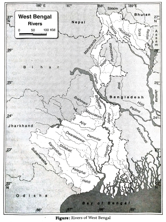
  4. Rivers of Sundarbans: Numerous rivers of this region are tide-fed and flow towards the west. Saptamukhi, Matla, Raimangal, Bidyadhari, etc., are the rivers of Sundarbans.
  5. Rivers of Kanthi region: The rivers of this region are tide-fed. Rasulpur and Champa are the rivers of the sandy area of Kanthi.
2. Describe in brief the rivers of North brief the rivers of North Bengal.
Ans. Rivers of North Bengal: Most rivers of North Bengal are fed by rainwater and glaciers. These rivers originate from different regions of the Himalayan range and according to the slope of the land, flow from north to south. A brief description of the rivers of North Bengal are given below-
  1. Teesta: It is the most important river of North Bengal. Teesta originates from the Jemu glacier, flows through the districts of Darjeeling and Jalpaiguri and finally drains into the Jamuna river of Bangladesh.
  2. Jaldhaka: This river originates from the mountainous terrains of the Sikkim-Bhutan border, flows through the districts of Jalpaiguri and Cooch Behar and finally meets the Jamuna river in Bangladesh.
  3. Mahananda: This river originates near the Mahaldiram Hills of the Himalayan range and flows southwards. It finally flows into the the Ganga and its main tributary Balasun river.
  4. Others: Some of the other notable rivers of North Bengal are Sankosh, Raidak and Torsa.
3. Describe the rivers of the plateau region of West Bengal.
Ans. Rivers of the plateau region of West Bengal: The characteristic features of the rivers of the plateau region of West Bengal are- (1) Most of the rivers of the western plateau region are the tributaries of the Bhagirathi-Hooghly. (2) The rivers have originated from the Chota Nagpur Plateau region. (3) Most of the rivers flow towards the east and south-east according to the slope of the land. (4) These are rain-fed rivers and thus their water content reduces in seasons other than monsoons. The major rivers of this region are-
  1. Damodar: It originates from the Khamarpat Hills of Palamau district in Jharkhand and joins river Hooghly downstream. One of its distributaries, Mundeswari, drains into the Rupnarayan. Damodar was a flood-prone river before the conceptualisation of the Damodar Valley Project, and was thus known as the ‘Sorrow of Bengal’.
  2. Kasai or Kangsabati: It originates from the Ajodhya Hills of Purulia district and flows to the south-east to meet river Keleghai. The combined flow of these two rivers is river Haldi, which meets river Hooghly. Kumari river is a tributary of this river.
  3. Dwarakeswer and Shilai or Shilabati: The combined flow of these two rivers near Ghatal in Paschim Medinipur is known as Rupnarayan. It then meets river Hooghly near Geonkhali in Purba Medinipur.
  4. Mayurakshi: It originates from the Chota Nagpur Plateau and flows through the state of Jharkhand. Later it enters the Birbhum district of West Bengal and joins river Bhagirathi at the end. Right bank tributaries of river Mayurakshi include Bakreswar, Kopai and left bank tributaries are Brahmani and Dwarka.
  5. Ajoy: It originates from the Chota Nagpur Plateau and flows through southern boundary of Birbhum district and then meets river Bhagirathi near Katwa in Purba Bardhaman district.
  6. Others: Another important river of this region is Subarnarekha. It originates from the Chota Nagpur Plateau in Jharkhand and flows through the southern part of Jhargram district of West Bengal and Odisha and then drains into the Bay of Bengal.
4. Give a brief description of the rivers flowing through the Rarh Plain and the Ganga Del region. Write the characteristics of the rivers of the Sundarban region. 
Ans. Rivers of the Rarh Plain: Most rivers of the Rarh Plain originate from the Chota Nagpur Plateau and flows across the western plateau region. These rivers either flow from west to east, or from west to south-east. Some important rivers of the Rarh Plain are briefly described below-
  1. Damodar: This river originates from the Khamarpat Hills of the Palamu district in Jharkhand. It flows through the western plateau and the Rarh Plain and drains into the Bhagirathi-Hooghly river. Mundeswari, a distributary of Damodar flows into the Rupnarayan river.
  2. Rupnarayan: The rivers Dwarekeswar and Shilai (or Shilabati) meet near Ghatal to form the Rupnarayan river. This river finally drains into the Hooghly river near Geonkhali.
  3. Others: Some other notable rivers of this region are-Kangsabati, Ajoy, Bakreswar, Mayurakshi and Dwarka.
Rivers of the Ganga Delta region: The Bhagirathi-Hooghly river is the most important river of this region. It flows through the western margin of the deltaic region in a north-south direction. Some rivers of this region which flow to the east of the Bhagirathi-Hooghly are Bhairab, Jalangi, Mathabhanga, Ichamati and Churni. These rivers flow from north to south as per the slope of the land. The rivers, Bhairab, Jalangi and Mathabhanga are the distributaries of the river Padma. Among these, Mathabhanga and Jalangi have drained into the Bhagirathi river. The southern part of the Mathabhanga river is called Churni. Ichamati is the distributary of Mathabhanga which finally drains into the Bay of Bengal.
The slope of the Ganga Delta region is low and so the rivers here take a meandering course and forms many estuaries, creeks and waterbodies. Some other rivers of the Sundarban region which are fed by tidal water are-Raimangal, Matla, Gosaba and Bidyadhari, etc.
Characteristics of the rivers of the Sundarban region: Most rivers of the Sundarban region are fed by tidal water, such as, Saptamukhi, Matla, Raimangal, Bidyadhari, etc. The characteristics of these rivers are- (1) The rivers are perennial as they are tide-fed. (2) The rivers have saline water. (3) The length of these rivers is short i.e., they have a short course. (4) These rivers have formed estuaries. (5) The mouth of these rivers are quite wide. (6) These rivers finally drain into the Bay of Bengal.

Short Explanatory Answer Type Questions

1. Why West Bengal is known as own as riverine or riparian state?
Ans. West Bengal is a riverine or riparian state with many rivers, tributaries, distributaries, etc. They all have formed a drainage network. The sources of these rivers are the Himalayan Range and western plateau or Chota Nagpur Plateau. These rivers drain into the Bay of Bengal. In addition to this, there are several tide-fed rivers of the Sunderban region. On one hand, all these rivers flowing across the state have made the plains of the state a fertile one by their silt deposition, on the other hand the water from these rivers is used for household, agricultural, industrial and various other purposes. Hence, it will not be wrong to call West Bengal a gift of the Ganga, Bhagirathi and their tributaries and distributaries. Thus, it is called a riverine or a riparian state.
2. What are characteristics of river of North Bengal?
Ans. Teesta, Torsa, Jaldhaka, Mahananda, Sankosh, Raidak, etc are notable rivers of North Bengal. Characteristics of these rivers are as follows-
  1. Snowfed rivers: Most of rivers are snowfed but some rivers have originated form springs.
  2. Follow the slope of land: Rivers flow towards south and south-east according to the slope of the land.
  3. Entry into Bangladesh: Most of the rivers of this region ultimately enter Bangladesh and join the river Jamuna (Brahmaputra). Though some of rivers also meet the river Padma.
  4. Perenniality: Being snowfed, the rivers carry water throughout the year and are thus perennial rivers.
  5. Presence of strong currents: The rivers flow rapidly in mountaineous regions and have strong currents. So they form narrow ‘v’ shaped valleys known as gorges in their course and these strong water currents are tapped for the hydroelectric power generation.
  6. Proneness to flood: The rivers are prone to flood as they enter the plains from the mountainous regions.
3. State the characteristics of rivers of the plateau area of West Bengal.
Ans. The characteristics of river of the plateau area of West Bengal are:
  1. The rivers are the tributaries of the Bhagirathi-Hooghly river.
  2. The rivers originate from Chota Nagpur Plateau region.
  3. The rivers are rainfed and so they remain dry except during the rainy season.
  4. The rivers flow from west to east or southeast.
4. Give an account of the rivers of Rarh Plain and the Gangetic Delta.
Ans. Rivers of the Rarh Plain: Most of the rivers in this region have their sources in the Chota Nagpur Plateau and they either flow to the east or southeast from west, following the slope of the land. For example, the Damodar river originates from the Khamarpat Hills of Palamau district of Jharkhand and meets the Bhagirathi-Hooghly to its east. A branch of river Damodar, known as Mundeswari meets the Rupnarayan river. The combined flow of Dwarakeswar and Shilabati rivers, after flowing towards the southeast, is known as Rupnarayan which meets the Hooghly river. Other notable rivers of this region include Kangsabati, Ajoy, Bakreswar, Mayurakshi, Dwaraka, etc.
Rivers of Gangetic Delta: The major river of this delta region is the Bhagirathi-Hooghly and its important tributaries are Ichamati, Churni, Jalangi, etc. These rivers flow from north to south over the deltaic plains. Besides, many rivers of the Sunderbans are fed by tidal waters, such as, Raimangal, Matla, Gosaba, Bidyadhari, etc.
5. Why are most of the rivers of the plateau region in West Bengal east flowing?
Ans. Notable rivers of western plateau of West Bengal are Ajoy, Mayurakshi, Damodar, Rupnarayan, Brahmani, Kopai, Dwarakeswar, Shilabati, etc. Most of the rivers have originated from the Chota Nagpur Plateau in the west and then they flow from west to east in the western plateau region according to the slope of the land. Most of the rivers meet the river BhagirathiHooghly at different places. General slope of the western plateau is from west to east. Hence, most of the rivers flow in this direction. These rivers are mainly rainfed in nature. Thus, in the rainy season most of the rivers cause flood in the adjacent areas due to excessive rainfall.
6. ‘The rivers of the western plateau region of West Bengal dry up during the dry season. Why?
Ans. The famous rivers of the western plateau region are the Damodar, Ajoy, Mayurakshi, Kangsabati, etc. The rivers dry up in the dry season because-
  1. Rainfed river: Most of the rivers of the plateau area are fed by rain water, and so it has water only during the rainy season.
  2. High temperature: The temperature of the summer season is about 40°C and hence the rate of evaporation is also very high during this time which leads to the drying up of waterbodies.
  3. Impact of dams: Various dams and reservoirs have been built in this area, which store the water and also regulate the water flow in rivers. Thus, in the lower courses of the river, the amount of water gets reduced as a result of this.
7. Why was river Damodar called the ‘Sorrow of Bengal’?
Ans. Damodar is the main river of western plateau and the Rarh region. The Damodar river rises in the Khamarpat Hills of the Palamau district of Jharkhand. It flows for a distance of 541km through the states of Jharkhand and West Bengal. The river has several tributaries, such as Barakar, Konar, etc in its upper course, i.e., in the Chota Nagpur Plateau region. Excessive rainfall in the upper course of the river during monsoon raises the water level in its lower course in West Bengal and floods the adjacent areas. This used to be a yearly phenomenon in the lower course of the river affecting the districts of Bardhaman, Bankura, Howrah, Hooghly, etc. A huge loss of life and property was the outcome of these floods, especially for the people residing along the banks of the river. This is why river Damodar was called the ‘Sorrow of Bengal’. However, the Damodar Valley Multipurpose Project has hugely helped to regulate the floods.
8. Why Kangsabati is called the ‘Sorrow of Medinipur’?
Ans. River Kangsabati has its source in the Ajodhya Hills of Purulia and flows through Bankura, Paschim Medinipur and Purba Medinipur districts. It meets river Haldi and drains into the Bay of Bengal. Due to a steep gradient in the upper course, the river water does not remain stagnated and flows according to the slope. But the gradient is very low in the lower course i.e., in Purba Medinipur district, and thus flooding occurs as a result of heavy rainfall in the upper course. Since these floods result in massive destruction of life and property here, Kangsabati is called the ‘Sorrow of Medinipur’.
9. Why are ‘khanris’/creeks found in the Sunderban region of West Bengal?
Ans. The mouth of wide rivers are usually known as ‘khanris’ or creeks. The numerous small channel-like waterbodies in the interior of the Sunderbans are known as ‘khanris’. The sea water enters through these channels into the interiors of Sunderbans as an action of regular tides. The same water again recedes during ebb. This regular advancement and recession of water has led to the formation of permanent channel called like waterbodies of short length ‘khanris’. The ones that have a longer length are called rivers. E. g., Saptamukhi, Jhilli, etc. The regular tidal action through the mouths of these khanris have led to the widening of the mouths and gradual narrowing down of these channels towards the interior of the land.
10. Discuss the utilisation of waterbodies, rivers, canals, wells, etc.
Ans. Waterbodies are very important to mankind. The various utilisation of waterbodies rivers, canals, wells, etc. are as follows
  1. Agricultural purpose: The state of West Bengal is agriculture oriented. Irrigational practices depend mainly on rivers, canals, etc.
  2. Transportation purpose: The river Bhagirathi-Hooghly is an important component of West Bengal’s transportation system.
  3. Drinking water and other household purpose: The purified water is utilised for drinking purpose. Other household chores such as cleaning, washing, cooking also involve the use of water.
  4. Industrial purpose: Water from rivers, canals, etc., contribute mostly to the development of the industrial sector and the process of manufacturing in factories. For example, many industries have developed on the banks of the river Hooghly.
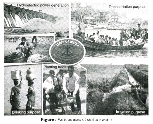
  5. Plantation: Water is used in social afforestation and agricultural afforestation. Huge amounts of water is used for planting trees in the western plateau region.
  6. Generation of electricity: The production of hydroelectric power is done from river dams. For example, from the waters of Mython, Panchet, Tilaiya dam on the river Damodar, hydroelectricity is produced.

Short Answer Type Questions

1. What is groundwater?
Ans. Groundwater refers to water present underground. When rainwater seeps through the soil layers and gets accumulated under the ground in the permeable rock layers, it is called groundwater.
2. What are the sources of irrigation in West Bengal?
Ans. Irrigation in West Bengal is carried out through wells, tubewells and canals.
3. Why does the river water of Teesta often pose a threat?
Ans. Teesta is the main river of North Bengal. It is extremely swift-flowing in this mountainous area, but when it enters the plains, the river velocity decreases. This river gets flooded when it is in spate during the monsoons. The river overflows its banks and floods its adjacent plain lands to a great extent thereby causing much loss to the life and property of the people. This is the reason why the Teesta often poses a threat’.
4. Why is the river Bhagirathi-Hooghly called the ‘Lifeline of West Bengal’?
Ans. The Bhagirathi-Hooghly river is the most significant river of West Bengal. Many tributaries join this river on both banks. This has resulted in the formation of a great plain and delta in the southern part of West Bengal. The plain formed is ideal for cultivation of crops. River Hooghly has an important role to play in supplying water to the industries located on either banks, supplying drinking and domestic water to the towns and cities, supplying water for irrigation to the agricultural fields, even acting as waterways (river transport). This is the reason why it is called the ‘Lifeline of West Bengal’.
5. Mention two harmful effects of overexploitation of groundwater.
Ans. Over-exploitation of groundwater has many harmful effects. Two of its effects are as follows- (1) continuous lowering of groundwater level (both pre-monsoon and post-monsoon), (2) arsenic contamination in groundwater.

Multiple Choice Type Questions [MCQ type]

Write the correct answer from the given alternatives

1. An important  river that flows through the Rarh region is-
A. Matla
B.. Teesta
C. Damodar
D. Churni
Ans. C
2. A snowfed river of West Bengal is-
A. Ganges
B. Saptamukhi
C. Ajay
D. Kangsabati
Ans. A
3. The source of river Barakar is-
A Ganga
B. Mahanadi
C. Damodar
D. Teesta
Ans. C
4. The most important river of North Bengal is-
A. Teesta
B. Torsa
C. Balasan
D. Jaldhaka
Ans. A
5. A tributary of Jaldhaka river is-
A. Rili
B. Sevok
C. Diana
D. Balasan
Ans. C

Very Short Answer Type Questions

Fill in the blanks with suitable words

1. …….. river flows through the KanthiDigha coastal area.
Ans. Rasulpur
2. A distributary of the Ganga river which enters into Bangladesh is ………
Ans. Padma
3. Hot springs are found in Bakreshwar in ………. district of West Bengal.
Ans. Birbhum
4. Rivers of North Bengal are ………
Ans. snowfed
5. The northern rivers, being swift flowing, facilitate ………. power generation.
Ans. hydroelectric
6. ……… river is called ‘sorrow of West Bengal’.
Ans. Damodar
7. Teesta river causes ………. floods.
Ans. destructive
8. Damodar river drains into the ……… river.
Ans. Hooghly
9. The rivers of the plateau region are ……….
Ans. rainfed
10. A right bank tributary of the Teesta river is ………..
Ans. Rangit

If the statement is true, write ‘T’ and if false, write ‘F against the following

1. Teesta is a rainfed river of West Bengal.
Ans. F
2. The origin of the Damodar river is Jemu glacier in the Eastern Himalayas.
Ans. F
3. The rivers of the Sundarbans are swift flowing.
Ans. F
4. The local name of Kangsabati is ‘Kansai’.
Ans. T
5. Rivulets known as ‘khanris’ are noticed along with the rivers of the Sundarban region.
Ans. T
6. Hooghly is a tributary of Kangsabati.
Ans. F
7. West Bengal is called the ‘Land of Rivers’.
Ans. T
8. Brahmani river is called the ‘Sorrow of Medinipur’.
Ans. F
9. Water that is released from the Damodar Canal causes flood in. Rarh region.
Ans. T
10. Haldi river flows through the Paschim Medinipur district.
Ans. F

Answer in one or two words

1. Name two snowfed rivers of West Bengal.
Ans. Teesta, Mahananda.
2. Which is the longest river of North Bengal?
Ans. Mahananda.
3. What is the combined flow of Dwarkeshwar and Shilai rivers called?
Ans. Rupnarayan.
4. What is the combined flow of the Kangsabati and Keleghai called?
Ans. Haldi.
5. The Sevoke bridge spans across which river?
Ans. River Teesta.
6. Name a river that flows over the western plateau area.
Ans. Damodar.
7. Name a tributary of Teesta river.
Ans. Rangpo.
8. Name two rivers of the Sundarbans.
Ans. Matla and Bidyadhari.
9. Name two tributaries of the Damodar river.
Ans. Konar and Barakar.
10. Name two tributaries of the Bhagirathi.
Ans. Mayurakshi and Ajoy.
11. Name a distributary of Damodar.
Ans. Mundeswari.
12. Which river bisects the mountainous area of north Bengal?
Ans. Teesta.

TOPIC – D

Climate

Long Answer Type Questions

1. Write a note on the characteristics of the climate of West Bengal. In which region of West Bengal are winter clothes required even in summer? 
Ans. Characteristics of the climate of West Bengal: The main characteristics of the climate of West Bengal are-
  1. Change of seasons: The main characteristic of the climate of West Bengal is season change. Summer, monsoon, autumn and winter are the four main seasons of West Bengal, that change in a cyclical way. Apart from that, before the arrival of winter, dewy season is observed that is known as late autumn, while spring marks the beginning of summer.
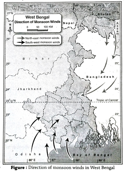
  2. Extensive impact of tropical monsoon wind: In summer the hot south-western monsoon winds and in winter the dry north-eastern monsoon winds blow over the state. These two winds bring hot-humid summers and cold-dry winters in West Bengal, respectively.
  3. Opposite direction of winds: In West Bengal, the direction of wind in summer is opposite to the direction of wind in winter.
  4. Wet summer and dry winter: Generally rainfall occurs in summer, so the summer is basically wet and humid. On the other hand, winter is dry in West Bengal. But a little amount of rainall occurs due to western disturbances.
  5. Northern region is rainfall prone: As a result of the south-west monsoon winds, West Bengal receives heavy rainfall in its Northern Himalayan region. The hilly regions of West Bengal receives an average. rainfall of 400 cm annually.
  6. Entire West Bengal except the mountainous region has moderate type of climate: As the northern part of West Bengal is a mountainous area, summers are pleasant here but winters are bitterly cold. In the rest of West Bengal the annual range of temperature is not very high. Pleasant climate prevails in the plains and coastal western regions. The plateau area (especially Purulia) experiences high summer temperatures. In Darjeeling district of northern mountainous region, summer temperature (16°C) being low, winter clothes are required in the summer as well. Temperature rapidly decreases here at night.
Darjeeling in the northern region of West Bengal requires winter clothes even in summer.
2. Explain the influence of monsoon winds on the climate of West Bengal.
Ans. Influence of monsoon winds on the climate of West Bengal: Two different types of winds blow over West Bengal- (1) humid south-west monsoon wind that blows during summer, and (2) dry north-east monsoon wind that blows during winter. These two winds are mainly responsible for regulating the climate of West Bengal.
  1. Change of season: The climate of West Bengal can be divided into 4 seasons according to the onset and retreat of these two wind systems. These are-(1) pre-monsoon or summer season, (2) monsoon or rainy season when the south-west monsoon winds are active, (3) retreat of the south-west monsoon winds or autumn season, and (4) onset of north-east monsoon winds or winter season.
  2. Determine climatic characteristics: Not only the demarcation of seasons, but also the climatic characteristics of West Bengal are influenced by the nature of monsoon winds.
  3. Low temperature during winter: The northeast monsoon winds blow from the north towards the south during winter (from December to February). Since these winds are cold, the temperature drops in West Bengal and it is known as the winter season. Rainfall does not occur in this season as these winds are dry.
  4. High temperature during summer: The north-east monsoon winds start retreating from West Bengal from the end of February and the south-west monsoon winds arrive during the interim period (from March to May). As a result, the temperature rises, and this period is known as summer season.
  5. Excessive rainfall during rainy season: The south-west monsoon wind blows over West Bengal from June to September. Since this wind is moisture-laden, the sky is overcast and rainfall occurs. This season is called the rainy season or monsoon season.
  6. Clear sky during autumn: During October to November, the south-west monsoon winds retreat. As a result the sky becomes clear and temperature gradually decreases.

Short Explanatory Answer Type Questions

1. Discuss the impact of season change on human life.
Ans. The impact of season change is observed not only on human body and mind, but also on their livelihood and economy of the region.
  1. Impact on body and mind: The change of season affects human body and mind heavily. For example, extreme hot weather brings tiredness and excessive cold temperature causes lethargy.
  2. Change in cultivation: Different crops are cultivated in different seasons. For example, vegetables grow well in winter. Winter is also ideal for cultivating ‘Rabi’ crops and rainy season is for ‘Kharif’ crops.
  3. Change in diet: The diet of human beings changes according to the season, because people consume seasonal fruits and vegetables available in the market.
  4. Change in biological processes: The duration of days and nights vary according to different seasons. Thus, the biological clock of human body changes accordingly.
  5. Impact on festivals and tourism: Durga puja, the main festival of West Bengal, is celebrated in autumn. Picnics, circuses, fairs etc. are held in winter. All these seasonal activities create employment, that affects human life. Season change also impacts tourism. For example, hilly regions attract more tourists during winter.
  6. Increase of diseases: Several diseases are caused due to season change. For example, cold and cough during rainy season, chicken pox in spring, etc., are seasonal diseases.
2. What is ‘El Nino’? What influence does ‘El Nino’ have on arrival of monsoon winds in West Bengal? 
Ans. Concept of ‘El Nino’: ‘El Nino’ is a local term meaning ‘Jesus Christ’. The warm current moving towards the south on certain years, in the Pacific Ocean, along eastern Peru, western part of Ecuador, etc., is called El Nino.
Effect of El Nino on the monsoon winds in West Bengal: In the years which are affected by El Nino, the south-west monsoon winds become less active, although its direct influence is not fully established. However, a link always exists between the occurrence of the El Nino phenomena and the prevalence of draught conditions in India. Since the south-west monsoon winds blow over West Bengal, along with the entire Indian subcontinent in general, El Nino influences the climate of West Bengal too. It is commonly seen that El Nino years coincide with draught conditions in West Bengal.
3. Discuss the main climatic factors of West Bengal.
Ans. The main climatic factors of West Bengal are-
  1. Tropic of Cancer: Since the Tropic of Cancer (23½° N) passes through West Bengal, the state (except the mountainous region of Darjeeling) is, warm in nature.
  2. Monsoon winds: The moisture-laden south-west monsoon winds blow over West Bengal during the rainy season causing widespread rainfall. Again, the dry north-east monsoon winds blow over the state causing no rainfall. These winds are cold since they arrive from mountainous areas. Thus, West Bengal experiences cold weather devoid of rainfall during the winter months.
  3. Altitude of the land: There is an inverse relationship between altitude and temperature. With every 1000 metre of ascent, the temperature drops at the rate of 6.4°C and hence the temperature decreases with increase in altitude. Since the Himalayan mountain regions are greater in altitude as compared to the plains, they have much lower temperature.
  4. Location of the Bay of Bengal: Since the Bay of Bengal lies to the south of West Bengal, it has a moderate climate with no extreme temperature.
  5. Location of the Himalayan mountains: The Himalayas are aligned from west to east across the northern part of the state. On one hand, it is responsible for causing rainfall (relief or orographic rainfall), while on the other, it acts as a barrier and prevents the cold winds (northeast monsoon winds) from blowing over the state during the winter months.
6. ‘A comfortable climate prevails in the northern hilly region.’ Explain.
Ans. During the summer season in West Bengal, the temperature is high in almost every region. The temperature of the northern hilly region is comparatively low and pleasant and therefore comfortable. The temperature decreases at the rate of 6.4°C per 100 m increase in altitude. The altitude of Darjeeling region is almost 2000 metre and hence the temperature is naturally low. The temperature here during the summer season is 15°C-18°C and thus the weather is pleasant in summer.

Short Answer Type Questions

1. How many seasons are observed in West Bengal?
Ans. There are 4 seasons in West Bengal. They are summer, monsoon, autumn and winter.
2. What do you mean by western disturbance?
Ans. During winter, cyclonic storms originating in the Mediterranean region, cause low pressure and sudden winter rain in northwest India. Such weather phenomenon is called western disturbance.
3. What is ‘Ashwiner Jhar’?
Ans. Generally, West Bengal does not experience rainfall during autumn. But sometimes the cyclones formed in the Bay of Bengal during autumn cause thunderstorms. This is known as ‘Ashwiner Jhar’.
4. What is ‘Kalbaisakhi’?
Ans. During early summer months, West Bengal and its adjoining areas are affected by thunderstorms and even hail storms, especially in the late afternoons. These storm winds blow from north-west direction and thus is known as ‘Norwester’ or ‘Kalbaisakhi’.
5. Where does snowfall occur in West Bengal?
Ans. The northern part of West Bengal, i.e., the Himalayan mountainous region experiences snowfall due to higher altitude, as the temperature decreases to below freezing point.

Multiple Choice Type Questions [MCQ type]

Write the correct answer from the given alternatives

1. The region receiving the heaviest rainfall in West Bengal is-
A. coastal area of Digha
B. northern mountainous region
C. western plateau region
D. Sundarbans region
Ans. B
2. The coldest district of West Bengal is-
A. Cooch Behar
B. Darjeeling
C. Purulia
D. Nadia
Ans. B
3. The factor which has an impact on human body and mind is-
A. ebb and tide
B. change of seasons
C. daily apparent speed of the earth’s rotation with respect to the sun
D. change in duration of day and night
Ans. B
4. Rainfall in West Bengal is caused by the-
A. south-west monsoon winds
B. south-east monsoon winds
C. north-west monsoon winds
D. north-east monsoon winds
Ans. A
5. Another name of Kalbaisakhi is-
A. Norwester
B. Tornedo
C. Mango Shower
D. burst of monsoon
Ans. A

Very Short Answer Type Questions

Fill in the blanks with suitable words

1. The ‘Ashwiner Jhar’ storm occurs in West Bengal during …….. season.
Ans. autumn
2. The driest district of West Bengal is ………
Ans. Purulia
3. The duration of ……… in West Bengal is from March to May. 
Ans. summer
4. ……… winds blowing from the Bay of Bengal cause rainfall all over West Bengal.
Ans. Monsoon
5. ……… seasons are mainly observed in West Bengal.
Ans. Four
6. The wettest district of West Bengal is ……..
Ans. Darjeeling
7. Climate of West Bengal is …….. in nature.
Ans. tropical monsoon
8. ……… season can be seen from December to February in West Bengal.
Ans. Winter

If the statement is true, write ‘T’ and if false, write ‘F against the following

1. Rainfall in West Bengal occurs due to south-west monsoon winds.
Ans. T
2. Rainy season prevails in West Bengal from June to September.
Ans. T
3. The driest district of West Bengal is Bankura.
Ans. F
4. West Bengal experiences cold temperate type of climate.
Ans. F
5. Summers are dry and winters are humid or wet in West Bengal.
Ans. F
6. The storms that occur during autumn in West Bengal are called ‘Aswiner Jhar’ storm.
Ans. T
7. Being at a higher altitude Darjeeling has a moderate type of climate.
Ans. F
8. Trade wind controls the climate of West Bengal.
Ans. F
9. Most of the rainfall in West Bengal iş occured due to effect of south-west monsoon winds.
Ans. T
10. The amount of rainfall increases from Darjeeling mountain region to the river Ganges.
Ans. F

Answer in one or two words

1. Which area in West Bengal receives maximum rainfall?
Ans. Buxaduar in Alipurduar.
2. Which is the hottest district in West Bengal? 
Ans. Bankura.
3. Which wind influences West Bengal’s climate the most?
Ans. Monsoon wind.
4. Which is the most famous animal of Jaldapara National Park?
Ans. One-horned rhinoceros.
5. In West Bengal, when does western disturbances occur?
Ans. Winter.
6. Which two districts in West Bengal have laterite soil?
Ans. Purulia and Jhargram.
7. Name two trees of the Western Plateau region.
Ans. Arjun and shimul.
8. Name two trees belonging to the plain region.
Ans. Mango and jamun.
9. Which district of West Bengal experiences cyclones frequency?
Ans. Purba Medinipur.
10. What are the seasons of West Bengal?
Ans. Summer, monsoon, autumn and winter.

TOPIC – E

Soil and Natural Vegetation

Long Answer Type Questions

1. Write the classification of soil in West Bengal and describe them in brief.
Ans. Classification of soil in West Bengal: According to the soil scientists soil is formed by the combined effect of climate, biosphere, relief, parental rock and time. For the variation of these soilforming elements, soil of West Bengal can be classified into different types. They are-
1. Soil of hilly region:
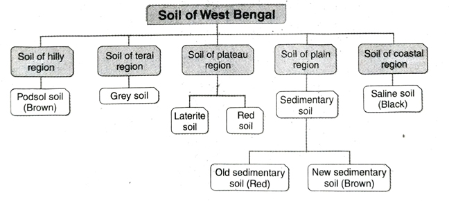
  1. Location: This type of soil mostly found in the districts of Darjeeling, Jalpaiguri, Alipurduar, parts of Cooch Behar, etc.
  2. Characteristics: (a) This is a type of podsol soil. (b) This soil is mostly brown in colour. (c) The fertility of this soil is medium.
  3. Crops produced: Tea, orange, cinchona, etc. are cultivated in this soil.
2. Soil of terai region:
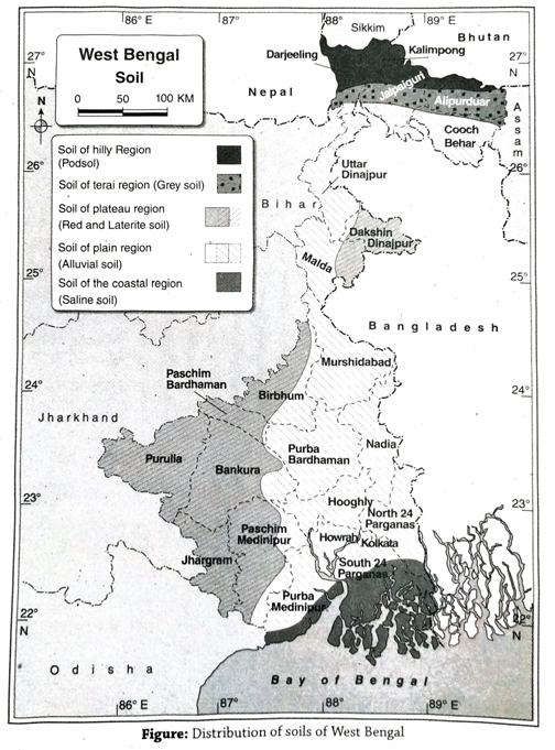
  1. Location: This type of soil is found at the foothills of the Himalayas.
  2. Characteristics: (a) This type of soil is full of pebbles. (b) This soil is grey in colour. (c) The soil fertility is medium.
  3. Crops produced: Paddy, wheat, tea, potato are cultivated in this soil.
3. Soil of plateau region:
  1. Location: This soil is mostly found in Purulia, Bankura, Birbhum, Paschim Bardhaman, Paschim Medinipur, Jhargram and Dakshin Dinajpur.
  2. Characteristics: (a) In this region, mostly two types of soil are foundlaterite soil at the west and red soil at the east. (b) Laterite soil is red in colour and hard as brick. This soil is infertile and the water holding capacity is very low. (c) Red soil is also red in colour. The texture of this soil is fine and iron content is very high. Water holding capacity of this soil is low and that is why, for cultivation irrigation is very important.
  3. Crops produced: Paddy (in a small amount), corn, potato, tobacco, etc. are the main crops produced.
4. Soil of the plain region:
  1. Location: This type of soil mostly found in Uttar Dinajpur, Murshidabad, Nadia, Purba Bardhaman, North and South 24 Parganas, Howrah, Hooghly, etc.
  2. Characteristics: (a) This type of soil is mostly acidic in nature. (b) This soil is mainly formed by the deposition of rivers. So, the amount of silt, sand and clay are high in this soil. (c) This is a fertile soil, mostly known as sedimentary soil or alluvial soil. (d) The old sedimentary soil is red in colour and less fertile. On the other hand, new sedimentary soil is brown in colour and more fertile.
  3. Crops produced: Paddy, wheat, jute, sugarcane, etc. are the main crops.
5. Soil of coastal region:
  1. Location: This type of soil is mainly found in the Sundarbans and Kanthi coastal regions in West Bengal.
  2. Characteristics: (a) This soil is saline in nature. (b) The texture of this soil is very fine. (c) Water holding capacity of this soil is low. (d) This soil is black in colour. and infertile in nature.
  3. Crops produced: In this soil the amount of salt is very high. That is why, with the help of rainwater harvesting the salinity of the soil is controlled that helps to cultivate crops like paddy (in a small amount), vegetables, coconut, betel nut, watermelon, etc.

Short Answer Type Questions

1. What type of soil is found in the plains of West Bengal?
Ans. In the plain region of West Bengal, riverborne fertile silt and silty loam soil is found.
2. Where is saline soil found in West Bengal?
Ans. Saline soil is found in the active delta (Sundarban) region of the southern part of West Bengal.
3. State the characteristics of mangrove forests.
Ans. Some of the characteristics of mangrove forests are as follows- (1) The trees have stilt roots to hold them firmly on the soil even during tidal surge. (2) Since the trees are often immersed in tidal waters, they have aerial roots or pneumatophores, which help in the process of respiration. (3) The trees carry out viviparous germination. These trees are evergreen in nature.
4. What is gully or khoai erosion?
Ans. Red soil-rich region in and around Shantiniketan in Birbhum district is prone to continuous rill, gully, sheet and ravine erosions. Therefore, the elevation of the land is decreasing day by day, which further leads to the formation of various landforms.

Multiple Choice Type Questions [MCQ type]

Write the correct answer from the given alternatives

1. Dry deciduous forest is seen in the-
A. mountainous regions
B. plateau regions
C. plain regions
D. delta region
Ans. B
2. Plants with round leaves are found in-
A. Purulia
B. Jalpaiguri
C. Malda
D. Sundarbans
Ans. D
3. Soil type of the mountainous region is suitable for growing-
A. plum
B. jackfruit
C. custard apple
D. orange
Ans. D
4. Khadar is the name for-
A. new alluvial soil
B. laterite soil
C. podsol soil
D. old alluvial soil
Ans. A
5. Podsol is found in West Bengal in-
A. mountainous region
B. plateau region
C. plain region
D. coastal region
Ans. A
6. Soil of the western plateau region is-
A. terai soil
B. laterite soil
C. red soil
D. alluvial soil
Ans. B
7. Colour of the soil of mountainous region inWest Bengal is-
A. red
B. brown
C. black
D. white
Ans. B

Very Short Answer Type Questions

Fill in the blanks with suitable words

1. Extensive occurrence of …….. trees has led to the etymology of ‘Sundarban’. 
Ans. sundari
2. Stilt roots and pneumotophores are found in ……… forests.
Ans. mangrove
3. ……… is an alpine tree.
Ans. Rhododendron
4. ………. soil is found in the coastal region of West Bengal.
Ans. Saline
5. ………. soil is red in colour.
Ans. Laterite
6. Soil is very fertile in the ………. region.
Ans. plain

If the statement is true, write ‘T’ and if false, write ‘F’ against the following

1. Laterite soil is found in the Rarh region.
Ans. T
2. Pneumatophores are found in Sundari trees.
Ans. T
3. Coastal soil is favourable for coconut cultivation.
Ans. T
4. The saline soil of Sundarbans is alkaline in nature.
Ans. T
5. Khoai erosion is seen in Rarh region.
Ans. T
6. Podsol soil is found in Bankura and Purulia districts of West Bengal.
Ans. F
7. Goran tree is found in western plateau region of West Bengal.
Ans. F
8. Natural vegetation of Sundarbans is called mangrove forest.
T
9. Laterite soil is ideal for cultivation.
Ans. F

Answer in one or two words

1. Which region of West Bengal accounts for the maximum forest cover?
Ans. Northern hilly region.
2. Which district accounts for maximum forest cover in West Bengal?
Ans. Darjeeling.
3. What is the colour of mountainous soil?
Ans. Brown.
4. Where did the name ‘Sundarbans’ originate from?
Ans. Sundari trees.
5. What is the type of soil in plain region?
Ans. Fertile alluvial soil.
6. Where is the saline soil found in West Bengal?
Ans. Southern coastal area of active delta.
7. Which place of West Bengal has been designated as UNESCO World Heritage Site?
Ans. Sundarbans.
8. Name one sanctuary of West Bengal.
Ans. Mahananda Wildlife Sanctuary.
9. Name two districts of West Bengal where laterite soil is found.
Ans. Purulia and Jhargram.
10. Name a tree found in the plains of West Bengal.
Ans. Mango tree.

TOPIC – F

Agriculture

Long Answer Type Questions

1. What are the characteristics of agriculture in West Bengal?
Ans. Characteristics of agriculture in West Bengal: Climate of West Bengal is tropical monsoon type. Impact of monsoon is great on agricultural practices of West Bengal. Characteristics of agriculture in West Bengal are-
  1. Monsoon-dependent agriculture: Agricultural practices of West Bengal are largely dependent on the south-west monsoon wind. The kharif crops are cultivated based on the arrival of monsoon rain. Thus crop cultivation is hampered because of the uncertainty of the monsoon rain.
  2. Intensive agriculture: Population density of West Bengal is very high. Therefore, the demand of food is also very high. That is why, intensive agriculture is practised in West Bengal.
  3. Labour-intensive agriculture: The agricultural practices of West Bengal are labour-intensive since use of machines is minimal. The farmers cultivate their fields with outdated implements like ploughs and bullocks.
  4. Livelihood-based agriculture: The agricultural practices of West Bengal are for the livelihood of the people. The cultivated crops are consumed by the farmers themselves since surplus is very less.
  5. Crop rotation system: The crop rotation system is followed to retain the fertility of the soil. A single piece of land is thus cultivated more than once to produce various crops.
  6. Importance of paddy cultivation: Since rice is the staple food of the people of West Bengal, paddy is cultivated in abundance. Moreover, the fertile silty soil of the delta regions as well as the warm and humid climate is conducive for paddy cultivation.
  7. Development of irrigation and cultivation of rabi crops: In winter, rabi crops are cultivated with the help of irrigation. The productivity of rabi crops is increased with the help of irrigation by wells, tubewells, and canals. The capacity of irrigation has been increased which facilitates productivity.
  8. Production of fishing and poultry farming besides crop cultivation: Since the main food of West Bengal comprises fish, egg, meat, etc., poultry-farming is gaining importance along with pisciculture besides the cultivation of crops.
  9. Agricultural development programmes: The development of agriculture has increased with the help of five year plans and 3-tier Panchayat Management System.
  10. Forecast of Green Revolution: After Green Revolution many modern measures have been taken in agricultural practice of West Bengal. It helps to increase production of crops in West Bengal.
2. Mention the tea producing regions of West Bengal. Describe the conducive factors for tea cultivation. 
Ans. Tea producing regions of West Bengal: Tea is a mild beverage and is a commercial/cash crop. Tea plantations are mostly found in tropical and sub-tropical regions. West Bengal ranks second in the production of tea in India. Tea producing regions of West Bengal can be classified into- 1. primary and 2. secondary regions.
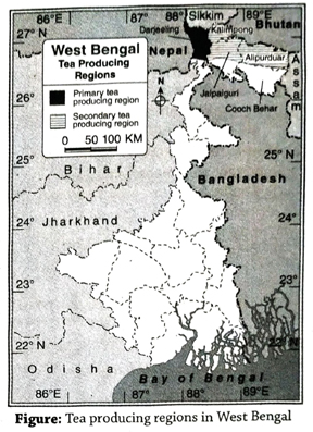
  1. Primary tea producing regions: Best quality flavoured tea is produced in the Darjeeling district. Along the hilly slopes ranging between 900 m to 2000 m altitude, have been made terraces for tea plantations. The most important tea producers here are Happy Valley, Makaibari, Sukhiapokhri, Kurseong, Bijanbari, etc.
  2. Secondary tea producing regions: Some other tea plantations are seen in Kalimpong, Jalpaiguri and the foothills of the Himalayas in the district of Alipurduar. Tea is also produced in the foothills of Himalayas of the Dooars region. Important tea producing centre of Dooars are Mal, Binaguri, Madarihat, Chalsha, Naxalbari, Kumargram, Nagarkata etc.
Conducive factors for tea cultivation: Conducive factors for cultivation of tea can be grouped into-
  1. Physical environment: The important factors are-
    1. Relief: Relief is an important factor for the cultivation of tea. Sloping land where water does not stand is required for tea cultivation and that is why hilly slopes are ideal locations. Since hilly soil areas are prone to erosion, terraces have been prepared along the contours for tea plantations.
    2. Climate: Hot and wet climate having a high amount of rainfall is necessary since they influence the flavour, colour and taste of tea. Rainfall ranging between 150 cm and 200 cm, and average annual temperature of 20°C -30°C and summer temperature of 27°C, is ideal for tea cultivation. Snowfall is harmful for tea plantations.
    3. Soil: Fertile, acidic, iron and manganese-bearing soils are ideal for tea cultivation. However, sufficient amounts of nitrogen, zinc and potassium are also needed.
  2. Man-made factors: Some of the important man-made factors are-
    1. Capital: Capital is needed for maintenance of tea gardens, labour wages, implements, fertilisers, pesticides etc.
    2. Labour: Skilled workers are required to pick tea-leaves. Large number of laboures are required for the tea processing work.
    3. Transport: Developed transport system is essential for exporting after processing it (since tea plantations are located in hilly areas).
    4. Others: Besides the above factors, advanced technology, demand for tea, administrative facilities, market etc., also influence production of tea.

Short Explanatory Answer Type Questions

1. Classify the agricultural crops that are produced in West Bengal.
Ans. Agricultural crops that are produced West Bengal can be classified on different basis. They are-
  1. On the basis of season: On the basis of season, the crops of West Bengal can be classified into three types-
    1. Kharif crops: Crops like aman (a type of Paddy), jute, sugarcane, etc. that are sown in the rainy season and harvested in winter are called kharif crops.
    2. Rabi crops: Crops like wheat, barley, jowar, gram, potato, etc. that are sown. in winter and harvested at the begining of summer are called rabi crops.
    3. Zaid crops: Crops like maize, groundnut, vegetables and fruits that sown in spring i.e. month of February-March and harvested at the begining of monsoon i.e., month of June are called zaid crops.
  2. On the basis of use: On the basis of use, the crops of West Bengal can be classified into two types-
    1. Food crops: Amongst the agricultural crops rice, wheat, barley, maize, etc. are called food crops, because these crops are cultivated mainly to use as food.
    2. Commercial crops: Agricultural crops like tea, jute, etc. are cultivated mainly to sell in the market for profit. These crops are called commercial crops. They are of three types-
      (a) Plantation crops: Crops that are cultivated in a large garden or estate with the help of modern technology, mainly for export are called plantation crops. Example-tea, coffee, rubber, etc.
      (b) Fibre crops: Crops that are cultivated for the production of fibre or thread are called fiber crops. Example-cotton, jute, mesta, etc.
      (c) Horticulture: Horticulture is cultivation of fruits, flowers, vegetables with the help of modern technology.
2. What are the importances of irrigation in West Bengal?
Ans. Irrigation is one of the key component for agricultural development in West Bengal, because-
  1. To reduce uncertainty of monsoon: In West Bengal rainfall is dependent mainly on south-west monsoon. This wind is uncertain thus causes flood or drought. Therefore, irrigation is important to reduce the uncertainty of agriculture in West Bengal.
  2. For cultivation of rabi crops: Winter is almost dry in West Bengal. In this time irrigation is needed for the cultivation of rabi crops.
  3. For cultivation of high yielding variety of crops: To fulfil the need of food for the growing population of West Bengal, cultivation of high yielding variety of crops is necessary. For this adequate amount of water is required throughout the year. That is why, irrigation is important in West Bengal to maintain the water supply.
  4. To reduce spatial variation of water holding capacity of soil: Different types of soil are found in different districts of West Bengal. Each of the soil has different texture, that effects its water holding capacity. Coarse-textured soil has poor water retaining capacity, that needs proper irrigation for cultivation.
  5. For water supply in dry region: The Western Plateau region of West Bengal receives less amount of rainfall. That is why, irrigation is important in this region of West Bengal for cultivation throughout the year.
3. ‘The plain region of West Bengal is ideal for paddy and jute cultivation.Explain.
Ans. In the plain region of West Bengal comprising Uttar and Dakshin Dinajpur, Malda, Murshidabad, Nadia, Purba Bardhaman, Hooghly, North and South 24 Parganas districts, production of jute and paddy are quite high. Because-
  1. Extensive plain land: Plain and flat land is needed for the cultivation of paddy and jute. Thus, plain areas are better for cultivation than the hilly and plateau regions.
  2. Fertile soil: The fertile silty soil is ideal for cultivation of paddy and jute and this type of soil is found in the plain region (including the Gangetic plain) of West Bengal.
  3. Availability of labour: Availability of cheap labour is important for cultivation of paddy and jute. Since the plains are densely populated, labour is abundant and readily available.
4. Agriculture in the Terai region is not developed’-Explain why.
Ans. The Terai region comprises of the subdivisions of Siliguri, Jalpaiguri and Alipurduar. The area is made up of unconsolidated sediments. The average altitude of the area ranges from 75 m to 150 m above sea level. Teesta, Torsa, Jaldhaka, Raidak, Sankosh, Mahananda, etc., deposit cobbles, pebbles and other finer sediments here. So, the region is not suitable for agriculture. On the other hand, the humid conditions are not favourable for cultivation here. However, tobacco and small quantities of paddy and various types of fruits are cultivated here.
5. ‘Agriculture is well-developed in the Gangetic delta.-Why?
Ans. The Gangetic delta region is famous for agriculture. Most of the people here depend on agriculture for their livelihood. The reasons for development of agriculture here are-
  1. Extensive plain area: The delta region is flat and plain and so it is favourable for agricultural practice as well as irrigation facilities.
  2. Fertile silty soil: The area is made up of silty sedimentary soil which is fertile and therefore favourable for agriculture.
  3. Appropriate temperature and rainfall: The temperature and rainfall of the tropical area is appropriate. Paddy, jute, and vegetables are cultivated here.
  4. High density of population: High density of population provides abundant labour required for agricultural practice. Demand of food is also high in this region. That is the reason why agricultural productivity is high here.

Short Answer Type Questions

1. West Bengal is famous for the cultivation of which crops?
Ans. West Bengal is famous for the cultivation of crops such as paddy, jute, tea, etc.
2. Which districts of West Bengal are wellknown for paddy cultivation?
Ans. Purba Bardhaman, Paschim Bardhaman Nadia, Murshidabad, Hooghly, North and South 24 Parganas, Purba and Paschim Medinipur districts of West Bengal are wellknown for paddy cultivation.
3. Which is the best place for tea cultivation in West Bengal?
Ans. In the northern parts of Darjeeling and Jalpaiguri districts and some places of North Dinajpur, tea is well-cultivated.
4. Name the high-yielding variety of jute seeds.
Ans. The high yielding variety of jute seeds areChaitali, Basudev, Sobujsona D-154, JRC1108, etc.
5. Mention some tea-producing areas of Darjeeling.
Ans. Happy Valley, Sukhiapokhri, Kurseong, Makaibari, Bijanbari, etc., are some of the notable tea-producing areas of Darjeeling.
6. Name some of the tea-producing areas of Dooars and Terai region.
Ans. Mal, Jayanti, Chalsa, Nagarkata, Madarihat, Kumargram, etc., are some of the teaproducing areas of the Dooars and Terai region.

Multiple Choice Type Questions [MCQ type]

Write the correct answer from the given alternatives

1. Among the following, the type of soil suitable for agriculture is-
A. laterite
B. silt
C. coastal
D. mountainous
Ans. B
2. Main agricultural product of Darjeeling is-
A. jute
B. tea
C. coffee
D. paddy
Ans. B
3. Which one of the following is not a high yielding variety of paddy seed?
A. Chaitali
B. Jaya
C. Ratna
D. Padma
Ans. A
4. Coffee is a-
A. plantation crop
B. fibre crop
C. food crop
D. none of these
Ans. A
5. In jute production, West Bengal ranks-
A. 1st
B. 2nd
C. 3rd
D. 4th
Ans. A
6. Jute that cultivated in West Bengal is a type of-
A. Tossa Jute
B. Golden Jute
C. White Jute
D. Yellow Jute
Ans. A

Very Short Answer Type Questions

Fill in the blanks with suitable words

1. ……… district is known as the ‘Rice bowl’ of West Bengal.
Ans. Purba Bardhaman
2. ………. is called golden fibre.
Ans. Jute
3. Sabujsona is a high yielding ………. seed.
Ans. Jute

If the statement is true, write ‘T’ and if false, write ‘F’ against the following

1. The main commercial crop of West Bengal is potato.
Ans. F
2. Tea is a cash crop.
Ans. T
3. Crops that are cultivated for earning money, are called cash crops.
Ans. T
4. Jute is the main agricultural crop of the Rarh region.
Ans. F
5. Oolong tea is very famous in China.
Ans. T
6. Purba Bardhaman district is called ‘Rice bowl of West Bengal’.
Ans. T
7. Kharif crops sown in winter season.
Ans. F

Answer in one or two words

1. Which position does West Bengal hold in India in terms of paddy cultivation?
Ans. First.
2. Name two commercial crops grown in West Bengal.
Ans. Tea and jute.
3. Name a jute research institute of West Bengal.
Ans. Nilgunj near Barrackpore.
4. Which two types of plantation crops are grown in West Bengal?
Ans. Tea and cinchona.

TOPIC – G

Industry

Long Answer Type Questions

1. What are the reasons for development of industries in West Bengal?
Ans. Reasons for development of industries in West Bengal: Among all human activities, industrial development is the most prominent one. Industries help to process different types of raw materials into various useful commodities that are beneficial for mankind. The factors causing industrial development may be grouped into two types- 1. Geographical factors and 2. Economic factors.
  1. Geographical factors: The geographical factors behind improvement of industries in West Bengal are as follows-
    1. Importance of raw materials: Raw material is the most important factor for industrial development. Certain characteristics of raw materials are important-(a) nature of utility of raw materials, (b) perishability of raw materials, (c) use of alternative raw materials.
    2. Availability of power/energy: Energy is required to run the equipments for processing the raw materials. Thermal power and hydroelectricity are the two most widely used powers.
    3. Congenial climate: Certain industries need specific climatic conditions. For example-dry climate for leather industry, sunny climate for film industry, humid climate for textile industry etc. Humid tropical climate, adequate temperature, suficient rainfall, etc. are favourable for development of industries in West Bengal.
    4. Supply of water: Large amount of water is required for any industry. Teesta, Torsa, Jaldhaka, Raidak, Damodar, Mahananda, BhagirathiHooghly are the major rivers of West Bengal. Thus adequate supply of water is also a favourable factor for development of industries.
    5. Presence of Kolkata and Haldia ports: Presence of parts like Kolkata and Haldia help in international trade through waterways. Import of machineries and other necessary equipments and export of finished products of different industries via these ports create favourable environment for establishment of industries in West Bengal.
  2. Economic factors: Most important economic factors for development of industries in West Bengal are as follows-
    1. Advanced transport system: Since the raw materials have to be brought to the industrial sites and the finished products to be taken to the domestic markets as well as for export, transport system plays a vital role. Developed transport network and accessibility are therefore important factors for industrial development.
    2. Availability of labour: Labour is essential for industrial development. Abundance of skilled labour is important for industrial development. Since West Bengal is densely populated, labour is readily available.
    3. Huge capital: Capital is needed for acquiring land for industries, bringing equipments, wages for labourers and procuring raw materials. Various governmental and non-governmental institution have invested huge capital for industrial development in West Bengal.
    4. Demand and market: If there is no demand for a particular commodity, production of that commodity is not required. This is the reason why demand and accessible markets are important factors for development of industries. Products that are produced in a industrial farm of West Bengal have a huge market in India.
    5. Political stability: The industrialists can invest in establishing industries if there is political stability instead of frequent change of power in any country or state.
2. Give an account of the main industries of West Bengal.
Ans. Main industries of West Bengal: Although West Bengal is mainly an agricultural state, industries have also flourished here. The main industries of West Bengal areiron and steel, jute and tea, food-processing, cotton textile, tourism, information technology (IT), etc.
  1. Iron and steel industry: The first iron and steel industry was established in Kulti (Paschim Bardhaman) in 1870. Another one was established in Burnpur in 1918. The Durgapur industrial belt has developed due to the abundant availability of iron ore, coal, water, electricity, labour, etc., in this region.
  2. Jute industry: West Bengal is the leading producer of jute in India. The first jute industry was established in 1855 in Rishra (Hooghly district). At present, there are about 59 jute mills located on either side of river Hooghly.
  3. Cotton textile industry: Cultivation of cotton does not take place in West Bengal, but based on the imported cotton, the cotton textile industry has developed here. The first cotton-textile industry was established in Ghusuri (Howrah district). Other centres are in Serampore, Shyamnagar, Sodepur, etc.
  4. Tea industry: This is an important industry of West Bengal. The first tea industry was established in 1834. Tea estates were established in Darjeeling, Jalpaiguri, Cooch Behar, etc., There are about 343 tea estates in West Bengal.
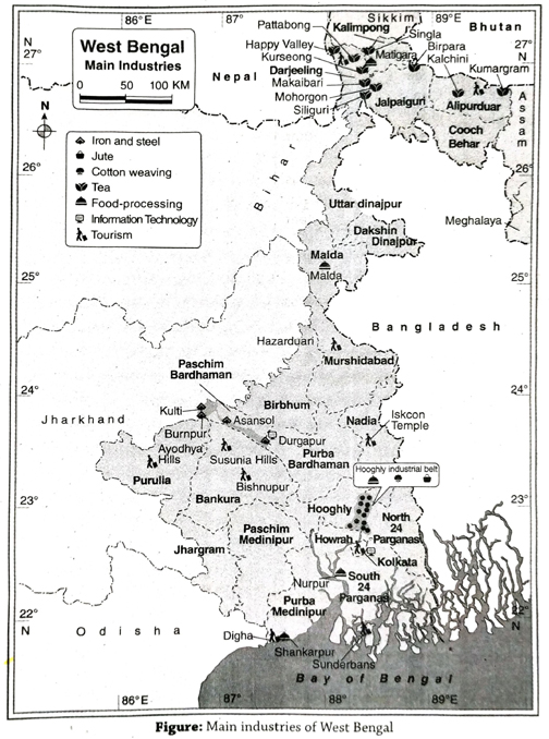
  5. Food processing industry: Food processing industry has developed in West Bengal due to its great demand. Kolkata, Shankarpur, Dumdum, Barasat, Malda are the main food processing centres in West Bengal.
  6. Tourism industry: Tourism industry has developed around various centres like religious places, hilly areas, sea beaches, educational centres, big cities, historical places, etc. Important tourist places of West Bengal are-Kolkata (Victoria Memorial, Alipore Zoo, etc.), Sundarbans, Digha, Darjeeling, etc.
  7. Information technology industry: This industry has developed in West Bengal and holds an important position in the state. The Electronics Complex (Software Park) of Salt Lake near Kolkata is famous and further development of this industry is taking place here.
3. Discuss the factors leading to the development of iron and steel industry in West Bengal.
Ans. Factors leading to the development of iron and steel industry in West Bengal: The main factors that have led to the development of iron and steel Industry in West Bengal may be grouped into two types-1. Geographical factors, 2. Economical factors.
  1. Geographical factors: Main geographical factors that help to develop iron and steel industries in West Bengal are as follows-
    1. Accessibility of raw materials: Raniganj, Andal, etc. of Paschim Bardhaman are important coal mine of West Bengal. Jharia, India’s largest coal mine is located near West Bengal. Thus coal are easily available in this region. In addition to this iron ore and limestone are also available in this region which helps to develop iron and steel industry in West Bengal.
    2. Accessibility of water: Sufficient supply of water is essential for iron and steel industry. Water of river Damodar is easily accessible to the iron and steel industry of West Bengal.
    3. Supply of energy: DVC (Damodar Valley Corporation), Maithon, Tilaiya, Panchet helps in hydroelectric and thermal power generation which facilitates the iron and steel industry of West Bengal.
  2. Economic factors:
    1. Abundance of labour: Cheap and skilled labour is available in the outskirts of West Bengal, Jharkhand, Bihar and Durgapur which helps to develop iron and steel industry.
    2. Well-developed communication system: This industrial centres are connected with Eastern Railway and Grand Trunk Road for import of machine and export of materials. This region is also connected with Hooghly industrial belt and Kolkata port via canals of the Damodar valley. It helps in import and export.
    3. Demand or market: The demand of the Durgapur-Asansol and the Kolkata industrial belts lead to industrial development.
4. Discuss the importance of small-scale industries in West Bengal.
Ans. Importance of small-scale industries: Small-scale industries are a grade higher than cottage industries. The total financial investment ranges from Rs. 75 lakhs to 1.5 crores involving construction of small factories, machines, etc. The small-scale industries are very significant in West Bengal. Importance of small scale industries are as follows-
  1. Financial investment: Investments in small-scale industries are of medium range. However, the overall financial investment is quite large indicating the importance of such industries.
  2. Employment: Many people are employed in small-scale industries which have led to the economic development of West Bengal. About 20 lakh people are engaged in the leather industry alone.
  3. Huge exports: A large market has developed for the products of the smallscale industries both in India and abroad. Thus, a huge amount of foreign exchange is earned from this industry. Items like leather goods, silk, cotton textile, gold jewellery, ceramic products, etc., are especially exported.
  4. Development of domestic trade and commerce: As a result of the flourishing small-scale industries, domestic or internal trade and commerce have increased. It is helpful for economic development of the country.
  5. Increase in infrastructure: Roads, electricity, water supply and other infrastructural facilities have developed around any area where small-scale industries are developing.

Short Explanatory Answer Type Questions

1. Why is Howrah called the ‘Glasgow of India’?
Ans. The headquarters of Howrah district is Howrah. Howrah, the second largest city of West Bengal is located opposite Kolkata on the western bank of the Hooghly river. Howrah is an important town of the Hooghly industrial region. Jute industry, engineering industry, cotton textile and other industries are developed here. A large number of engineering industries are situated here like the Glasgow city of England, so the city is called the ‘Glasgow of India’.
2. Why is Durgapur called the ‘Steel City’? 
Ans. Durgapur is one of the modern industrial cities in West Bengal. Here the engineering industries are highly developed. The Durgapur Steel Plant (DSP), Alloy Steel Plant (ASP), Central Mechanical Research Institute are located here. In the steel factory of Durgapur, ‘stainless steel’ is made by mixing chromium and nickel. With the help of the joint venture of Canada and Japan, alloy steel is manufactured here. The variety of steel projects has made Durgapur a ‘Steel City’.
3. Durgapur is called the ‘Ruhr of India’.
Ans. Ruhr is a small tributary river of river Rhine of Germany. Industries have developed in this area based on coal found in abundance here. The whole region is called the Ruhr Industrial Region.
In West Bengal, coal is found in the Damodar river valley of Paschim Bardhaman district. The iron and steel industry, cement industry, engineering industry, etc. have developed here based on available storage of coal. That is why, Durgapur is called the ‘Ruhr of India’.
4. Write a short note on IISCO.
Ans. The first iron and steel industry of India was established in Kulti in 1870 and another one was established in Burnpur in 1918. The Indian Iron and Steel Company (IISCO) is the colaboration of these two plants. During the fifth five year plan another iron and steel plant was established at Durgapur in Paschim Bardhaman district with the help of IISCO. Later it was. amalgamated with a government organisation named SAIL.
Causes of development: The main causes of development of IISC are as follows-
  1. Availability of coal from Raniganj and Jharía coal mine;
  2. Accessibility of iron ore from Noamudi, Gua Jharkhand and Gorumahisani, in Badampahar in Odisha;
  3. Available of other raw materials such as limestone (Birmitrapur), manganese (Gangpur) and dolomite;
  4. Abundance of water from Damodar and Barakar river;
  5. Availability of power resources from Durgapur and Mejia thermal power plant etc.
5. Discuss the problems and prospects of the iron and steel industry of West Bengal. 
Ans. Problems of iron and steel industry: Main problems of iron and steel industry of West Bengal are-
  1. Unavailability of raw material when required: Since only coal is available in West Bengal, other raw materials of iron and steel industry have to be brought from Jharkhand and Odisha. Thus raw materials are not always available as needed. It results in low productivity.
  2. Lack of modern technology: Lack of modern technology and equipments are the main problem for the development of iron and steel industries in West Bengal.
  3. Unavailability of adequate skilled labour: Although there are abundance of labours in West Bengal but number of adequate skilled labour is very less. It is one of the major constraint for development of iron and steel industry.
Other problems for the development of iron and steel industries in West Bengal are-4. Lack of extensive land, of 5. Lack capital, 6. Unavailability of coking coal, 7. Excessive transport cost, 8. Labour unrest etc.
Prospects of iron and steel industry: In West Bengal, after independence, increase in the rate of demand for steel is more than that of its production. Steel is exported to Bangladesh, Sri Lanka, etc., from West Bengal. The prospects of the iron and steel industry in West Bengal is quite commendable. Supply of iron and steel will increase with the completion of the undergoing projects of construction of iron and steel industries.
6. Discuss the problems and prospects of tourism industry in West Bengal.
Ans. Problems of tourism industry in West Bengal: The main problems of tourism industry in West Bengal are-
  1. Lack of infrastructure: Infrastructure of the tourism industry is very underdeveloped. The roads, houses and connectivity are in dismal condition.
  2. Lack of security: The main problem of the industry is lack of proper security.
  3. Lack of maintenance: Historical statues, buildings are ill maintained. It is one of the major problem of tourism industry.
Prospects of tourism industry in West Bengal: Prospects of tourism industry in West Bengal are as follows
  1. Tourism fair: Foreign tourists are interested in tourism fairs that are held here.
  2. New tourists spots: New tourist spots are being explored for development of more tourist destinations.
  3. Infrastructural development: New hotels, resort are being constructed to facilitate the growth of industries in this state. The infrastructural development with government aid will help the industry to develop further.
7. Discuss the problems and prospects of information technology industry in West Bengal.
Ans. Problems of information technology industry: The main problems of information technology industry in West Bengal are-
  1. Lack of extensive land: Land problem exists in Kolkata and its surrounding areas where the industries are to come up. Land is either scarcely available or prices are too high.
  2. Lack of infrastructure: The lack of infrastructure increases the problem of this industry.
  3. Disruption in the flow of work: A continuous interaction with the western countries throughout the day and even at night is required in case of the information and technology industry. However, certain factors like strikes, road-blocks, disputes regarding law and order disrupt this interaction, thereby causing hindrance in the flow of work.
Prospects of information technology industry: Prospects of information technology industry in West Bengal is increasing, because-
  1. 1 acre-25 acre land have been handed over to 41 companies in Rajarhat.
  2. The ‘Look East’ policy has helped in the growth of the industry.
  3. The SEZ have been formed for this industry.

Short Answer Type Questions

1. What is information technology?
Ans. Information technology refers to the storage, receiving, sending, coding, decoding and editing of data with the help of computer and telecommunication.
2. What are different part of information technology industry?
Ans. Collection of datas, analysis of collected data, research, tranformation and deletion of data through the computer and telecommunication system are used for business purpose. Main sections of IT industries are as software production, telephone service, centre for data collection and maintenance, data exchange centre etc.
3. State the major companies associated with the food processing industry of West Bengal.
Ans. The major food processing companies areMother Dairy, Haldiram’s, Anmol Biscuit Limited, Raja Biscuit, K C Das and Sons, etc.
4. Where and when was the first jute mill established in West Bengal?
Ans. The first jute mill was established in Rishra of Hooghly district of West Bengal in 1855.
5. When and where was the first cotton mill established in Kolkata?
Ans. The first cotton mill was established in 1818 in Ghusuri of Howrah.
6. What is outsourcing?
Ans. The process of carrying out work in a comparatively cheaper way and to increase the standard and skill of a company, by an overseas organisation is called outsourcing. Since the service cost is less in India, much of the work from America and Europe is sent here (in the form of data) which is processed and sent back. Kolkata is a leading provider of outsourcing.
7. What is food processing industry.
Ans. Industry that deals with packaging and processing of food is called food processing industry. In this industry, food that are perishable and cannot be consumed directly are processed through different scientific processes, like preservation, refrigeration, canning, irradiation, drying, salting, smoking and fermentation. Example-fruit juice, jam, jelly, pickle, chips producing industries.

Multiple Choice Type Questions [MCQ type]

Write the correct answer from the given alternatives

1. Most developed industry of Salt Lake is that of-
A. iron and Steel
B. information technology
C. jute
D. cotton and textile
Ans. B
2. The dairy industry in West Bengal has developed in-
A. Raichak
B. Haldia
C. Kakdwip
D. Dankuni
Ans. D
3. Iron and steel industry has developed in-
A. Kharagpur
B. Kakdwip
C. Durgapur
D. Islampur
Ans. C
4. Food Processing Research Centre is located at-
A. Barasat
B. Naihati
C. Panagarh
D. Asansol
Ans. A
5. The process of collection of data, hardware and software related activities form the-
A. tourism industry
B. tant industry
C. information technology industry
D. food processing industry
Ans. C

Very Short Answer Type Questions

Answer in one or two words

1. Which city is called the ‘Ruhr of India’?
Ans. Durgapur.
2. Which industry is called ‘Sunset industry’ in India?
Ans. Jute industry (In dissenting opinion petrochemical industry).
3. Name two areas of milk processing industry.
Ans. Dankuni and Asansol.
4. Name two centres of mineral water processing in West Bengal.
Ans. Kalyani and Berhampore.
5. Name two food parks of West Bengal.
Ans. Shankarpur and Kakdwip.
6. Which city is called the ‘Glasgow of India’?
Ans. Howrah.
7. What is the full form of SEZ?
Ans. Special Economic Zone.
8. Which is the main industry of Hooghly industrial belt?
Ans. Jute industry (in dissenting opinion engineering industry).
9. What is the full name of SAIL?
Ans. Steel Authority of India limited.
10. Which is the largest cottage industry of West Bengal?
Ans. Handloom industry.

TOPIC – H

City, Port and Tourist Place

Long Answer Type Questions

1. What are the main cities and towns of West Bengal? Give an account of Kolkata as the capital of the state. 
Ans. The main cities and towns of West Bengal: The census of India has designated those places as cities which have the following criteria-a population of more than 5000, population density of more than 400 persons per sq km, and at least 75% of the people engaged in non-agricultural activities. The major cities of West Bengal include-Kolkata, Darjeeling, Jalpaiguri, Siliguri, Alipurduar, Cooch Behar, Durgapur, Krishnanagar, Bolpur, Raniganj, English Bazar, Medinipur, Bankura, Malda, Bardhaman, Asansol, Haldia, Berhampore, Purulia, Shantipur, Chakdah, Ranaghat, Nabadweep, Balurghat, Chandannagar, Barrackpore, Howrah, Alipore, Barasat, Kalyani, Bongaon, Basirhat, etc.
Kolkata as a capital of West Bengal: Kolkata is the capital city of West Bengal. Thus it is of much importance in this state.
  1. Location: The capital of West Bengal, Kolkata is situated on the left bank of river Hooghly about 130 km inland from the mouth of river Ganga. This is one of the most significant cities in India.
  2. Year of establishment: Job Charnock, the governor of the East India Company established the city of Calcutta on August 24, 1690. The three villages of Sutanuti, Govindapur and Kalikata were united to form this city. Calcutta was the capital of India under the British rule till 1911. In 2001, the government of West Bengal decided to change the name of Calcutta to Kolkata officially.
  3. Importance of the city of Kolkata: Kolkata is a very important city. Some of the important features of Kolkata are as follows-
    1. Commercial capital: Having an area of about 185 sq. km, Kolkata is India’s main commercial centre and the capital of West Bengal.
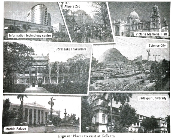
    2. City of Palaces: Kolkata boasts of having quite a number of beautiful palaces and heritage buildings (like, Marble Palace of Raja Rajendra Mullick in north Kolkata, Rabindranath Tagore’s house in Jorasanko, Palace of Sovabazar, etc.). This is why Kolkata is known as the ‘City of Palaces’.
    3. Population: Kolkata is one of the most important cities of India and the city’s population is about 4496694 (2011) and the population density is about 24306 persons per sq. km (2011).
    4. Centre of education, culture, trade and commerce: Kolkata is the main centre of education, culture, trade and commerce of east and north-east India.
    5. Industrial centre: Many industries have developed with Kolkata as its centre, like, jute industry, engineering industry, textile industry, paper industry etc.
    6. Centre of communication: Kolkata is the headquarter of the eastern and south-eastern railways. Dumdum, the only international airport of east India, is in Kolkata. National Highways like NH 2, NH 34, NH 35 and NH 6 all pass through Kolkata.
    7. Others: Other significant features of Kolkata are-(i) The only underground metro railway in eastern India is located here. (ii) Kolkata is the main port of West Bengal. (iii) The popular tourist spots of Kolkata are-Museum, Alipore Zoo, Victoria Memorial Hall, Birla Planetarium, Science City, etc. (iv) As per the book entitled ‘City of Joy’ by the famous author Dominique Lapiere, the people of Kolkata are ever-happy in spite of all the sufferings endured by them. That is why it is called the ‘City of Joy’.
2. Mention the major ports of West Bengal, State the importance of Kolkata port. 
Ans. VMajor ports of West Bengal: The term ‘port’ has been derived from the Latin word ‘parte’ meaning ‘entrance door’. In other words, a port means a place where entry is made between land and sea and also from sea to land through which transport or flow of goods and passengers is made.
The major ports of West Bengal are Kolkata (located on the left bank of river Hooghly) and Haldia. They are riverine ports.
Importance of Kolkata port: Kolkata is a riverine port. About 130 km inland from the Bay of Bengal, it is located on the left bank of river Hooghly. The hinterland of Kolkata port covers an area of about 13 lakh sq km. Kolkata port plays a vital role in the economic development of West Bengal.
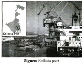
  1. Control over trade: Kolkata port has a very significant role in the economy of West Bengal and even north-east India as well as Nepal and Bhutan. The exports and imports of this vast region are all handled by this port.
  2. Earning foreign exchange: Since international trade is carried out through this port, the city earns foreign exchange.
  3. Aid to industries: Products of West Bengal like jute products, coal, tea (from Assam, Darjeeling), iron-ore (from Bihar and Odisha), mica, etc., are all exported from this port.
  4. Aid to agriculture: Fertilisers, pesticides, equipments, etc., required for agricultural practices are imported through this port.
  5. Employment opportunities: Lakhs of people are either directly or indirectly influenced by this port for getting employment opportunities in the agricultural, industrial, trade and commerce sectors, etc. Besides, a large number of people also get employment as labourers within the port area itself.
  6. Development of transport: Taking advantage of the Kolkata port, a good network of roads, railways and water transport have developed not only in West Bengal, but also throughout north-east India.
  7. Import of food crops: Since West Bengal is not totally self-dependent on food crops produced in the state, a lot has to be imported through the Kolkata port.
These are the reasons why the port of Kolkata is such a significant port among all other ports of West Bengal.
3. Discuss the reasons for the rise and fall of Kolkata port.
Ans. Reasons for the rise or development of Kolkata port: The conducive factors leading to the development of Kolkata port are—
  1. British interest: The port of Kolkata was established in the nineteenth century during the British period. They established it on the banks of river Hooghly in order to facilitate transport of industrial raw materials, defence equipments, etc. to India.
  2. Navigability of Bhagirathi-Hooghly river: Since the depth of the river is more and navigability of this river is quite high, ships could ply smoothly through this river to the sea.
  3. Resource-rich hinterland: The Kolkata port has a huge hinterland encompassing almost the whole of eastern India. This region has rich natural resources like tea, jute, rice, etc., (agricultural) as well as coal, iron ore, mica, etc., (minerals), along with forest-based resources. Besides, the established industries of tea, jute, engineering, cement, paper, etc., have made this region densely populated.
  4. Availability of labour: Kolkata being a densely populated metropolis, labourers, required for port activities are easily available.
  5. Developed transport system: Kolkata is linked to all parts of eastern India through a well-developed transport network like south-eastern railway, national highways (like NH 6 and NH 34) etc.
  6. Conducive physical environment: The areas in and around Kolkata have the advantage of having flat places and delta, congenial moderate climate, etc., which are all conducive to the development of a port.
  7. Location of centre of trade: Kolkata being the main industrial and trade centre of eastern India, has naturally developed as a port.
Reasons for the downfall of Kolkata port: This port is gradually losing its significance due to the following factors-
  1. Decrease in navigability of Kolkata port: Due to continuous siltation on the river bed over a long period of time, the river bed has risen and therefore navigability has decreased. As a result, ships cannot ply much inland from the sea through this river.
  2. Meandering nature of river: Numerous meanders of the river from its mouth to the Kolkata port, hinder the smooth plying of big ships inland.
  3. Presence of huge sandbars in the river: The river has about 14-15 big sandbars stretching from the mouth of the river to Kolkata port. This is why large ships cannot enter Kolkata port easily.
  4. Lack of space and infrastructure in the port: Due to lack of space, many ships cannot be anchored at the same time. Lack of jetties also hamper loading and unloading of larger quantities of materials from ships.

Short Explanatory Answer Type Questions

1. Discuss the causes of development of the Haldia port.
Ans. The causes of development of the Haldia Port are as follows
  1. As a support to help the Kolkata port: The importance of Kolkata port has decreased since the navigability of river Hooghly has decreased due to siltation. As a result, big ships are not able to enter the port. This is the reason why the port of Haldia has been established at the junction of Hooghly and Haldi rivers.
  2. Easy availability of land: Easy availability of land has facilitated infrastructural development of the Haldia port.
  3. Fulfilling the demand for trade and commerce: The import and export of raw materials and products through Haldia port fulfills the demand for trade and commerce and this helps in the development of this port.
2. Why is Siliguri called ‘the Gateway of North-east India’?
Ans. Siliguri is the headquarters of Darjeeling district. The NH 31 and NH 34 pass through this town. These national highways are connected with Bihar, West Bengal, Assam, Arunachal Pradesh, Nagaland, Manipur, Mizoram and Tripura. The eastern railway, north-eastern railway and Bagdogra airport are located here, which connect Kolkata, Patna and Guwahati. This is why Siliguri is known as ‘the Gateway of North-east India’.
3. What are the bases of origin of cities in West Bengal?
Ans. West Bengal has the second highest population density (1028 persons per sq. km) in India, after Bihar. The bases of origin of cities in West Bengal are as follows-
  1. Educational and cultural centre: Proper educational and recreational facilities enhance the growth of a city. People are also attracted to the cultural centre of a region, that helps to develop a city. Example-Shantiniketan.
  2. Tourist centre: A famous tourist spot always attracts people from different places. It helps to grow restaurents, lodges and other business opportunities that leads to origin of a city. ExampleDarjeeling.
  3. Commercial centre: A commercial centre always tends to grow business and supports employment, that helps to develop a city. Example-Haldia.
  4. Industrial centre: An industrial centre always tends to increase productivity that increase employment facilities and leads to population growth. As a result, a city develops. Example-Asansol.
  5. Mining centre: Cities may also develop around mines, because of employment opportunities and other socio-economic facilities. Example-Raniganj city around coal mine.
4. Kolkata and Howrah are called ‘Twin Cities’. Explain.
Ans. The two main and significant cities of West Bengal are Kolkata and Howrah. These cities are located on either banks of river Hooghly. Kolkata is located on the eastern bank and is the capital of West Bengal, while Howrah which is the main industrial city of West Bengal lies on the western bank of the Hooghly river. These two cities are connected by two bridges which have been built over river Hooghly- the Howrah Bridge or Rabindra Setu and Second Hooghly Bridge or Vidyasagar Setu. Kolkata is the centre of trade and commerce, politics and culture. On the other hand, Howrah is known as the ‘Glasgow of India’ and stands out as an important industrial centre. These two cities are dependent on each other and this is the reason why they are called ‘Twin Cities’.

Short Answer Type Questions

1. What is a city?
Ans. A city is a place where the minimum population is at least 5000 and the population density is more than 400 per sq – km and at least 75% of the total population is engaged in non-agricultural activities. For example, Asansol.
2. What is a megalopolis?
Ans. The Greek word ‘Megas’ means big. Megalopolis means a big city. It has a population of more than 10 lakhs. For example, Kolkata.
3. Mention some of the tourist places in Kolkata.
Ans. The tourist places of Kolkata are-Indian Museum, Victoria Memorial Hall, Birla Planetarium, Science City, etc.
4. Who established the city of Kolkata and when?
Ans. Kolkata was founded by Job Charnock in 1690. The city was founded by combining the 3 villages of Kolikata, Sutanuti and Gobindapur.

Multiple Choice Type Questions [MCQ type]

Write the correct answer from the given alternatives

1. The most urbanised district of West Bengal is-
A. Howrah
B. Bankura
C. Kolkata
D. Paschim Bardhaman
Ans. C
2. ‘Adra’ in Purulia district is a-
A. fishing centre
B. district headquarters
C. healthy place
D. railway junction
Ans. D
3. District town of Purba Medinipur is-
A. Digha
B. Kanthi
C. Tamluk
D. Ghatal
Ans. C
4. Fishing port has developed in-
A. Sankarpur
B. Krishnanagar
C. Durgapur
D. Islampur
Ans. A
5. Santiniketan is situated in-
A. Purba Bardhaman
B. Nadia
C. Howrah
D. Birbhum
Ans. D
6. An example of Land port is-
A. Haldia
B. Kolkata
C. Berhampur
D. Petrapole
Ans. D
7. Plassey is situated in-
A. Murshidabad
B. Bankura
C. Howrah
D. Hooghly
Ans. A

Very Short Answer Type Questions

Fill in the blanks with suitable words

1. Apart from Kolkata, ………. is an important port of West Bengal.
Ans. Haldia
2. …….. is called the ‘City of Palaces’.
Ans. Kolkata
3. As per census report, 2011, the population of West Bengal is ……….
Ans. 91,276,115
4. As per census report, 2011, the population density of West Bengal is ………
Ans. 1028 persons/sq km
5. Hazarduari is situated in ………. district.
Ans. Murshidabad
6. The biggest city of the Ganga delta region is ……….
Ans. Kolkata
7. A tourist spot in West Bengal is ………. Hill.
Ans. Tiger
8. According to population density West Bengal ranks ……… position in India.
Ans. second
9. Imambara is located in …….. district.
Ans. Hooghly
10. English Bazar is the headquarters of ………. district.
Ans. Malda

If the statement is true, write ‘T’ and if false, write ‘F’ against the following

1. The highest railway station of India is Ghoom.
Ans. T
2. Pedong is a small town near Kalimpong.
Ans. T
3. A historical tourist spot in West Bengal is Hazarduari.
Ans. T
4. Darjeeling is a hill station.
Ans. T
5. The headquarters of Murshidabad district is Chinsura.
Ans. F
6. Kolkata and Howrah are called ‘Twin Cities’.
Ans. T
7. Sajnekhali is a spectacular spot in the Sundarbans.
Ans. T
8. Berhampore is called the ‘City of Palaces’.
Ans. F
9. Hoogly port is a contemporary or supportive port of Kolkata port.
Ans. F
10. Bird sanctuary is located in Jalpaiguri district.
Ans. F

Answer in one or two words

1. Balurghat is the headquarters of which district?
Ans. Dakshin Dinajpur.
2. Which city is called ‘City of Joy’?
Ans. Kolkata.
3. What is the capital of West Bengal?
Ans. Kolkata.
4. In which district is Bolpur located?
Ans. Birbhum.
5. Which is the commercial hub’ of north Bengal?
Ans. Siliguri.
6. Name the associate port of Kolkata.
Ans. Haldia.
7. How many ‘million cities’ are there in West Bengal?
Ans. Two.
8. In which district is the Iscon temple located?
Ans. Nadia.
9. What is the main attraction of Jaldapara National Park?
Ans. One-horned rhinoceros.
10. Which city is called ‘the black diamond city’ of West Bengal?
Ans. Asansol.

Follow on Facebook page – Click Here

Google News join in – Click Here

Read More Asia News – Click Here

Read More Sports News – Click Here

Read More Crypto News – Click Here

Leave a Reply

Your email address will not be published. Required fields are marked *